
Lake Austin, formerly Lake McDonald, is a water reservoir on the Colorado River in Austin, Texas. The reservoir was formed in 1939 by the construction of Tom Miller Dam by the Lower Colorado River Authority. Lake Austin is one of the seven Highland Lakes created by the LCRA, and is used for flood control, electrical power generation, and recreation.

The Kings River is a 132.9-mile (213.9 km) river draining the Sierra Nevada mountain range in central California in the United States. Its headwaters originate along the Sierra Crest in and around Kings Canyon National Park and form the eponymous Kings Canyon, one of the deepest river gorges in North America. The river is impounded in Pine Flat Lake before flowing into the San Joaquin Valley southeast of Fresno. With its upper and middle course in Fresno County, the Kings River diverges into multiple branches in Kings County, with some water flowing south to the old Tulare Lake bed and the rest flowing north to the San Joaquin River. However, most of the water is consumed for irrigation well upstream of either point.

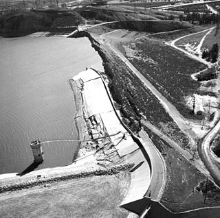
The St. Francis Dam was a concrete gravity dam located in San Francisquito Canyon in Los Angeles County built from 1924 to 1926 to serve Los Angeles's growing water needs. It catastrophically failed in 1928 due to a defective soil foundation, claiming the lives of at least 431 people. The collapse of the St. Francis Dam is considered to be one of the worst American civil engineering disasters of the 20th century and remains the second-greatest loss of life in California's history, after the 1906 San Francisco earthquake and fire.

The Tuolumne River flows for 149 miles (240 km) through Central California, from the high Sierra Nevada to join the San Joaquin River in the Central Valley. Originating at over 8,000 feet (2,400 m) above sea level in Yosemite National Park, the Tuolumne drains a rugged watershed of 1,958 square miles (5,070 km2), carving a series of canyons through the western slope of the Sierra. While the upper Tuolumne is a fast-flowing mountain stream, the lower river crosses a broad, fertile and extensively cultivated alluvial plain. Like most other central California rivers, the Tuolumne is dammed multiple times for irrigation and the generation of hydroelectricity.

Warragamba Dam is a heritage-listed dam in the outer South Western Sydney suburb of Warragamba, Wollondilly Shire in New South Wales, Australia. It is a concrete gravity dam, which creates Lake Burragorang, the primary reservoir for water supply for the city of Sydney. The dam wall is located approximately 65 kilometres (40 mi) to the southwest of Sydney central business district, near the town of Wallacia.

Kelly Barnes Dam was an earthen embankment dam in Stephens County, Georgia, just outside the city of Toccoa. Heavy rainfall caused it to collapse on November 6, 1977, and the resulting flood killed 39 people and caused $2.8 million in damage. The dam was never rebuilt.

The Feather River is the principal tributary of the Sacramento River, in the Sacramento Valley of Northern California. The river's main stem is about 73 miles (117 km) long. Its length to its most distant headwater tributary is just over 210 miles (340 km). The main stem Feather River begins in Lake Oroville, where its four long tributary forks join—the South Fork, Middle Fork, North Fork, and West Branch Feather Rivers. These and other tributaries drain part of the northern Sierra Nevada, and the extreme southern Cascades, as well as a small portion of the Sacramento Valley. The total drainage basin is about 6,200 square miles (16,000 km2), with approximately 3,604 square miles (9,330 km2) above Lake Oroville.

The River Poulter which rises near Scarcliffe in Derbyshire, England is a tributary river of the River Idle in Nottinghamshire. It supplied power to mills along its route, most of which are now gone, although their mill ponds remain. Cuckney mill building is used as a primary school. The river has been dammed to create several lakes in the Dukeries estates of Welbeck Abbey and Clumber House now the National Trust property of Clumber Park. The ornamental Gouldsmeadow Lake, Shrubbery Lake and Great Lake on the Welbeck estate are supplied by a tributary of the Poulter, while Carburton Forge Dam and Carburton Dam were built to power a forge and a mill. Clumber Lake, consisting of an upper and lower lake, which is spanned by a Grade II* listed ornamental bridge, is part of the Clumber estate, and has suffered from subsidence.

The Columbia Basin Project in Central Washington, United States, is the irrigation network that the Grand Coulee Dam makes possible. It is the largest water reclamation project in the United States, supplying irrigation water to over 670,000 acres (2,700 km2) of the 1,100,000 acres (4,500 km2) large project area, all of which was originally intended to be supplied and is still classified as irrigable and open for the possible enlargement of the system. Water pumped from the Columbia River is carried over 331 miles (533 km) of main canals, stored in a number of reservoirs, then fed into 1,339 miles (2,155 km) of lateral irrigation canals, and out into 3,500 miles (5,600 km) of drains and wasteways. The Grand Coulee Dam, powerplant, and various other parts of the CBP are operated by the Bureau of Reclamation. There are three irrigation districts in the project area, which operate additional local facilities.

Lake Oroville is a reservoir formed by the Oroville Dam impounding the Feather River, located in Butte County, northern California. The lake is situated 5 miles (8.0 km) northeast of the city of Oroville, within the Lake Oroville State Recreation Area, in the western foothills of the Sierra Nevada. Known as the second-largest reservoir in California, Lake Oroville is treated as a keystone facility within the California State Water Project by storing water, providing flood control, recreation, freshwater releases assist in controlling the salinity intrusion into the Sacramento-San Joaquin Delta and protecting fish and wildlife.

The New Croton Dam is a dam forming the New Croton Reservoir, both parts of the New York City water supply system. It stretches across the Croton River near Croton-on-Hudson, New York, about 22 miles (35 km) north of New York City.

San Luis Dam is a major earth-filled dam in Merced County, California, which forms San Luis Reservoir, the largest off-stream reservoir in the United States. The dam and reservoir are located in the Diablo Range to the east of Pacheco Pass and about 10 miles (16 km) west of Los Banos. San Luis Dam, a jointly-owned state and federal facility, stores more than 2 million acre feet (2.5 km3) of water for the California State Water Project and the federal Central Valley Project. Although the dam is located in the valley of San Luis Creek, the majority of its water comes from man-made aqueducts which are supplied from other rivers in Northern California.

The California State Water Project, commonly known as the SWP, is a state water management project in the U.S. state of California under the supervision of the California Department of Water Resources. The SWP is one of the largest public water and power utilities in the world, providing drinking water for more than 23 million people and generating an average of 6,500 GWh of hydroelectricity annually. However, as it is the largest single consumer of power in the state itself, it has a net usage of 5,100 GWh.

The Kaweah River is a river draining the southern Sierra Nevada in Tulare County, California in the United States. Fed primarily by high elevation snowmelt along the Great Western Divide, the Kaweah begins as four forks in Sequoia National Park, where the watershed is noted for its alpine scenery and its dense concentrations of giant sequoias, the largest trees on Earth. It then flows in a southwest direction to Lake Kaweah – the only major reservoir on the river – and into the San Joaquin Valley, where it diverges into multiple channels across an alluvial plain around Visalia. With its Middle Fork headwaters starting at almost 13,000 feet (4,000 m) above sea level, the river has a vertical drop of nearly two and a half miles (4.0 km) on its short run to the San Joaquin Valley, making it one of the steepest river drainages in the United States. Although the main stem of the Kaweah is only 33.6 miles (54.1 km) long, its total length including headwaters and lower branches is nearly 100 miles (160 km).
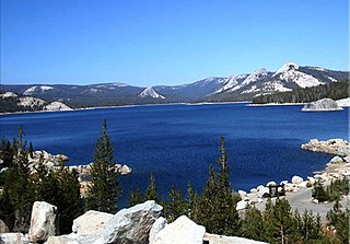
Courtright Reservoir is a reservoir in Fresno County, California. The reservoir is at an elevation of 8,170 feet in the Sierra National Forest, in the Sierra Nevada Mountain Range, bordering the John Muir Wilderness.

The Oroville–Thermalito Complex is a group of reservoirs, structures, and facilities located in and around the city of Oroville in Butte County, California. The complex serves not only as a regional water conveyance and storage system, but is the headwaters for, and therefore perhaps is the most vital part of, the California Department of Water Resources' State Water Project, the world's largest publicly built and operated water and power development and conveyance system.

Caliraya Dam is an embankment dam located in the town of Lumban province of Laguna, in the Sierra Madre Mountain Range of the Philippines. The reservoir created by the dam, Lake Caliraya, initially supplied one of the oldest hydroelectric plants in the Philippines, and later became a popular recreational area for numerous water sports and fishing. The dam's construction was started in 1939 under the supervision of the architecture firm of Pedro Siochi and Company and a small hydroelectric plant was operated in 1942.
The Van Norman Dams, also known as the San Fernando Dams, were the terminus of the Los Angeles Aqueduct, supplying about 80 percent of Los Angeles' water, until their damage in the 1971 San Fernando earthquake and were subsequently decommissioned due to the inherent instability of the site and their location directly above heavily populated areas.

The Middle Fork American River is one of three forks that form the American River in Northern California. It drains a large watershed in the high Sierra Nevada west of Lake Tahoe and northeast of Sacramento in Placer and El Dorado Counties, between the watersheds of the North Fork American River and South Fork American River. The Middle Fork joins with the North Fork near Auburn and they continue downstream to Folsom Lake as the North Fork, even though the Middle Fork carries a larger volume of water.

Wishon Dam is a dam in Fresno County, California in the Sierra National Forest, in the Sierra Nevada Mountain Range. It impounds the North Fork Kings River to form Wishon Reservoir.


