1928 Austin city plan

Last updated
Front cover of the 1928 city plan A City Plan for Austin, Texas.pdf
Front cover of the 1928 city plan

The 1928 Austin city plan (also known as the 1928 Austin master plan) was commissioned in 1927 by the City Council of Austin, Texas. It was developed by consulting firm Koch & Fowler, which presented the final proposal early the next year. The major recommendations of this city plan related to Austin's street plan, its zoning code, and the development of major industries and civic features, but it is most remembered for institutionalizing housing segregation by designating East Austin as the city's negro district.

Contents

History

The city of Austin, Texas, was established in 1839 to become a planned capital for the Republic of Texas. [1] Texas President Mirabeau B. Lamar appointed his friend Edwin Waller to oversee the surveying of the new city and to develop a city plan for its layout. [2] Waller and fellow surveyors laid out a grid plan fourteen city blocks wide, with a central four-block town square meant for the Texas Capitol. This "Waller Plan" determined the shape of what is now downtown Austin, and it was not until the 1870s that Austin expanded significantly beyond the bounds of the 1839 city plan. [1]

Road map of Austin in 1920 Austin TX 1920 map.jpg
Road map of Austin in 1920

By the early 1900s, Austin had developed a number of suburbs surrounding the original downtown street grid, and growth began to strain the city's transportation infrastructure, especially at the crossings of the Colorado River, Shoal Creek, and Waller Creek. Citizens and businesses increasingly pressed city leaders to pave the dirt roads and otherwise improve the road network. Also, the City Beautiful movement inspired general interest in beautifying public spaces, as well as making them more functional. In 1926 City Council created a commission charged with the development of a new master city plan aimed at all these ends. The next year, the commission hired the Dallas consulting firm Koch & Fowler to develop a comprehensive plan for Austin's urban development. [3] :8–11

Race and zoning

From the Civil War to the early 1900s, most of Austin's African American population lived in a number of freedmen communities distributed across the city, such as Clarksville and Wheatville. [4] :13 White city leaders were interested in moving black residents out of the central city and concentrating them into a racial ghetto on less valuable land, [5] in part to reduce the cost of providing "separate but equal" racially segregated public amenities throughout the city. [6] In 1917 the U.S. Supreme Court ruled in Buchanan v. Warley that the enforcement of racial housing segregation through local ordinances was unconstitutional, [7] but the city continued to search for a way to establish de facto housing segregation in Austin that could satisfy this new legal standard, and this was to be one of the goals of the new city plan. [5]

City plan

Proposed system of municipal parks and boulevards from the plan A City Plan for Austin, Texas.pdf
Proposed system of municipal parks and boulevards from the plan

Koch & Fowler submitted their finished proposal to City Council in January 1928, in a document titled "A City Plan for Austin, Texas". The 80-page report included a large section on the development of the city's street plan, another on the design and placement of municipal parks and other urban green spaces, and a number of shorter sections on other public amenities such as public schools, cemeteries, fire stations, and a proposed civic center. Other sections discuss the development of the city's railroad and streetcar networks, the desirability of a municipal airport, the establishment of a new municipal zoning code and rules for land subdivision, and the city's integration into the development of the surrounding region. [8]

The "Street plan" section noted that the Waller Plan's street grid continued to serve the central city well, but that the shortage of paved roads combined with the impact of obstructions such as the Capitol and the University of Texas campus forced excessive traffic onto a handful of streets. [8] :4–5 Detailed recommendations for the expansion and improvement of particular streets filled most of the section. In particular, it proposed the construction of four new bridges to connect central Austin with its suburbs, three of which were eventually built as the West Fifth Street Bridge, the Lamar Boulevard Bridge, and the Interstate 35 Bridge. The report emphasized the potential aesthetic value of bridges and other new constructions, urging that they be given ornamental designs. [3] :11–12

The "Parks and boulevards" section argued for the importance of public green spaces to the physical and emotional health of citizens, recommending locations for new or improved park facilities throughout the city. [8] :20–21 It noted the good condition of the three surviving park squares from the Waller Plan (Republic Square, Wooldridge Park Square, and Brush Square) and their value to the city as "beauty spots and breathing spaces". [8] :25–26 The plan recommended the preservation of greenbelts along Shoal Creek and Waller Creek and the banks of the Colorado River, as well as other wooded areas within the city. [8] :27–30

One section of the plan called for the development of a new civic center district on the north shore of the Colorado, to include a new municipal auditorium and event center, and a new central library downtown. [8] :42 Another section called for the creation of a municipal airport, suggesting that it be built in southeast Austin on what is now the neighborhood of Travis Heights. [8] :38–39

Housing segregation

One of the city plan's recommendations, detailed mainly in the "Schools" section, is the establishment of a "negro district" on the southeast fringe of the city, east of East Avenue (now Interstate 35) and south of the City Cemetery, [6] which the plan identified as the neighborhood with the highest preexisting concentration of black residents. [8] :57 After noting that explicitly racial zoning was not legally feasible (thanks to Buchanan v. Warley), the document advises that the city concentrate all public amenities aimed at black citizens in this region, so as to draw the black population to it. [5]

Legacy

Proposed system of zoning from the plan A City Plan for Austin, Texas.pdf
Proposed system of zoning from the plan

In response to the plan, City Council adopted a resolution defining new city limits and establishing Austin's first zoning code. [6] Later in 1928, Austin voters approved a municipal bond package providing $4.5 million (equivalent to $77,000,000in 2022) in funds to implement many of the city plan's recommendations. These bonds paid for the construction of new boulevards, bridges, culverts, public schools, playgrounds, and city parks around Austin, as well as a new central library (now the Austin History Center) and an expansion of Brackenridge Hospital. [3] :12 They also funded the establishment of Robert Mueller Municipal Airport, opened in 1930 on the northeast edge of the city. [9] The civic auditorium the plan called for was not built at the time, but thirty years later the city built the Palmer Auditorium across the river from the site the plan recommended; it has since been redeveloped into the Long Center for the Performing Arts. [10]

East Austin

Though the vast majority of its contents dealt with the sorts of city planning issues that still confront Austin today (transportation, utilities, parks, schools), [6] the 1928 master plan is mainly remembered today for its role in establishing East Avenue/Interstate 35 as the dividing line between the majority-white central city and the majority-black district of East Austin. [11] The "pull" incentives recommended in the city plan were complemented by "push" incentives when the city avoided extending the sewer system or paved roads into the existing freedmen communities elsewhere in Austin, and real estate "redlining" also pushed African Americans east of the central city. [4] :13–14 By 1932 almost all of the city's black residents had relocated to East Austin, and the other black communities across the city had largely disappeared. [5] This pattern of racial housing segregation persists in Austin to the present day, though its effects have been eroded by subsequent court rulings and legislation from the Civil Rights Era. [11]

West Austin

The community of Wheatville, a historic Black community in Austin encompassed by modern day West Campus, saw its decline as a result of African Americans being pushed out of the community area. The city excluded Wheatville from essential amenities such as trash collection, electricity, paved streets, and water services. Despite being home to one of the city's trash dumps, residents did not receive regular trash collection, and city garbage wagons often dumped refuse along the streets. These discriminatory practices, combined with the influx of students and rising property prices, led many Black residents to leave Wheatville in search of better living conditions elsewhere, particularly in East Austin. [12]

Related Research Articles

<span class="mw-page-title-main">Sixth Street (Austin, Texas)</span> United States historic place

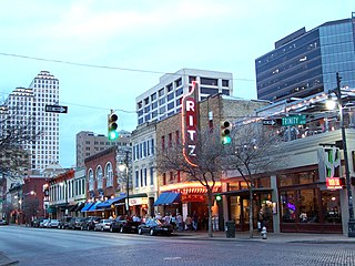
Sixth Street is a historic street and entertainment district in Austin, Texas, located within the city's urban core in downtown Austin. Sixth Street was formerly named Pecan Street under Austin's older naming convention, which had east–west streets named after trees and north–south streets named after Texas rivers.

<span class="mw-page-title-main">Hyde Park (Austin, Texas)</span> United States historic place

Hyde Park is a neighborhood and historic district in Austin, Texas. Located in Central Austin, Hyde Park is defined by 38th Street to the south, 45th Street to the north, Duval Street to the east, and Guadalupe Street to the west. It is situated just north of the University of Texas and borders the neighborhoods of Hancock and North Loop.

<span class="mw-page-title-main">Old West Austin Historic District</span> Historic district in Texas, United States

The Old West Austin Historic District is a residential community in Austin, Texas, United States. It is composed of three neighborhoods located on a plateau just west of downtown Austin: Old Enfield, Pemberton Heights, and Bryker Woods. Developed between 1886 and 1953, the three historic neighborhoods stretch from Mopac Expressway east to Lamar Boulevard, and from 13th Street north to 35th Street. It borders Clarksville Historic District and the West Line Historic District to the south.

<span class="mw-page-title-main">History of Austin, Texas</span>

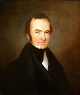
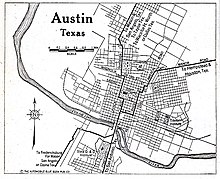
After declaring its independence from Mexico in March, 1836, the Republic of Texas had numerous locations as its seat of government. This being seen as a problem attempts were made to select a permanent site for the capital. January, 1839, with Mirabeau B. Lamar as the newly elected president, a site selection commission of five commissioners was formed. Edward Burleson had surveyed the planned townsite of Waterloo, near the mouth of Shoal Creek on the Colorado River, in 1838; it was incorporated January 1839. By April of that year the site selection commission had selected Waterloo to be the new capital. A bill previously passed by Congress in May, 1838, specified that any site selected as the new capital would be named Austin, after the late Stephen F. Austin; hence Waterloo upon selection as the capital was renamed Austin. The first lots in Austin went on sale August 1839.

<span class="mw-page-title-main">Clarksville Historic District (Austin, Texas)</span> Historic district in Texas, United States

The Clarksville Historic District in Austin, Texas, is an area located west of downtown Austin near Lady Bird Lake and just northeast of the intersection of the Missouri Pacific Railroad and West Tenth Street. Many historic homes and structures are located within the Clarksville Historic District. While Clarksville is geographically part of the Old West Austin Historic District, it is distinct from the two historic neighborhoods of Old Enfield, which lies immediately to the north on the eastern side of Texas State Highway Loop 1, and Tarrytown, which is situated to the west and northwest on the western side of Mopac.

West Campus is a neighborhood in central Austin, Texas west of Guadalupe Street and its namesake, the University of Texas at Austin. Due to its proximity to the university, West Campus is heavily populated by college students.

Allandale, Austin, Texas is a neighborhood in North Central Austin, in the U.S. State of Texas known for its large lots, mature trees, and central location.

East César Chávez, historically and originally named Masontown or Masonville, is a neighborhood in Austin, Texas. It is located in the central-east part of Austin's urban core on the north bank of the Colorado River. The neighborhood encompasses much of ZIP code 78702.

<span class="mw-page-title-main">Central East Austin, Austin, Texas</span> Neighborhood in Austin, Texas, United States

Central East Austin is a neighborhood in Austin, Texas, United States. The neighborhood is bounded to the south by East 7th Street, to the west by Interstate 35, to the north by East Martin Luther King Jr Boulevard and to the east by Chicon Street, Rosewood Avenue and Northwestern Avenue.

<span class="mw-page-title-main">Shoal Creek, Austin, Texas</span> River in the United States

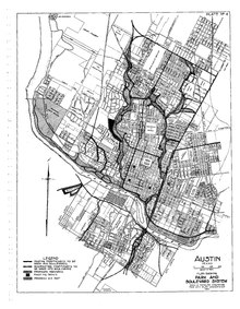
Shoal Creek is a stream and an urban watershed in Austin, Texas, United States.

<span class="mw-page-title-main">History of African Americans in Austin</span>

The history of African Americans in Austin dates back to 1839, when the first African American, Mahala Murchison, arrived. By the 1860s, several communities were established by freedmen that later became incorporated into the city proper. The relative share of Austin's African-American population has steadily declined since its peak in the late 20th century.

<span class="mw-page-title-main">West Sixth Street Bridge</span> Historic bridge in Austin, Texas

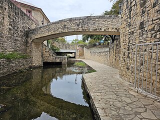
The West Sixth Street Bridge is a historic stone arch bridge in downtown Austin, Texas. Built in 1887, the bridge is one of the state's oldest masonry arch bridges. It is located at the site of the first bridge in Austin, carrying Sixth Street across Shoal Creek to link the western and central parts of the old city. The bridge was added to the National Register of Historic Places in 2014.

Wheatville was a historically black neighborhood in the city of Austin, Texas.

<span class="mw-page-title-main">Roberts Clinic</span> United States historic place

Roberts Clinic, a historic Colonial Revival building completed in 1937, was the first medical facility in Austin, Texas established to provide hospital rooms and care exclusively for the comfort of American Black patients. The practice offered treatment for acute and chronic illnesses, preventive treatment, minor surgeries, labor, delivery, and abortion services through the 1960s.

<span class="mw-page-title-main">West Fifth Street Bridge at Shoal Creek</span> Historic bridge in Austin, Texas

The West Fifth Street Bridge is a historic cantilever concrete girder bridge in downtown Austin, Texas. Built in 1931, the bridge carries Fifth Street across Shoal Creek to link central Austin with neighborhoods that were then the city's western suburbs. It is one of only a handful of curved cantilever girder bridges in Texas, built as part of the city's 1928 master plan for urban development and beautification. The bridge was added to the National Register of Historic Places in 2019.

<span class="mw-page-title-main">Waller Plan</span> Austin City Plan by Edwin Waller on 1839

The 1839 Austin city plan is the original city plan for the development of Austin, Texas, which established the grid plan for what is now downtown Austin. It was commissioned in 1839 by the government of the Republic of Texas and developed by Edwin Waller, a Texian revolutionary and politician who would later become Austin's first mayor.

<span class="mw-page-title-main">Third Street Railroad Trestle</span> Historic railroad bridge in downtown Austin, Texas

The Third Street Railroad Trestle is a historic wooden railroad trestle bridge crossing Shoal Creek in downtown Austin, Texas. Built around 1922 by the International–Great Northern Railroad, it replaced an earlier bridge in the same place. The bridge was used by the I–GN Railroad, the Missouri Pacific Railroad, and the Missouri–Kansas–Texas Railroad until 1964, when commercial rail traffic stopped; after 1991 the bridge was abandoned. It was added to the National Register of Historic Places in 2021.

<span class="mw-page-title-main">Anderson Stadium</span> Historic football stadium in east Austin, Texas

Anderson Stadium, also known as Yellow Jacket Stadium, is a historic football and track and field facility in East Austin, Texas. The stadium was built in 1953 as the football facility on what was then the campus of L.C. Anderson High School, Austin's only public high school open to African Americans under racial segregation. Closed in 1971 as part of a school integration plan and restored in the 1990s, Anderson Stadium was added to the National Register of Historic Places in 2022.

<span class="mw-page-title-main">Waller Creek</span> River in the United States

Waller Creek is a stream and an urban watershed in Austin, Texas, United States. Named after Edwin Waller, the first mayor of Austin, it has its headwaters near Highland Mall and runs in a southerly direction, through the University of Texas at Austin and the eastern part of downtown Austin, including the Red River Cultural District, to its end at Lady Bird Lake.

References

  1. 1 2 Humphrey, David C. "Austin, TX (Travis County)". Handbook of Texas Online . Texas State Historical Association . Retrieved March 26, 2021.
  2. "West Sixth Street Bridge at Shoal Creek" (PDF). National Park Service . June 24, 2014. p. 7. Retrieved March 26, 2021.
  3. 1 2 3 "West Fifth Street Bridge at Shoal Creek" (PDF). Texas Historical Commission . October 21, 2019. Retrieved March 26, 2021.
  4. 1 2 Hill, Sharon (2012). Wilson, Bonnie Tipton (ed.). "The Empty Stairs: The Lost History of East Austin" (PDF). Intersections: New Perspectives on Texas Public History. Texas State University. 1 (1): 12–18. Retrieved March 26, 2021.
  5. 1 2 3 4 Phillips, Alberta (August 31, 2012). "Proof of Austin's past is right there — in black and white". Austin American-Statesman . Retrieved March 26, 2021.
  6. 1 2 3 4 Gregor, Katherine (February 5, 2010). "Austin Comp Planning: A Brief History". Austin Chronicle . Retrieved March 26, 2021.
  7. Silver, Christopher (1997). "The Racial Origins of Zoning in American Cities". In Thomas, J. M.; Ritzdorf, M. (eds.). Urban Planning & the African American Community: In the Shadows. Thousand Oaks, CA: SAGE Publishing. ISBN   0-8039-7233-4.
  8. 1 2 3 4 5 6 7 8 Koch & Fowler (January 14, 1928). "A City Plan for Austin, Texas" (PDF). City of Austin. Retrieved March 26, 2021.
  9. Ragsdale, Kenneth Baxter (2007). Austin, Cleared for Takeoff: Aviators, Businessmen, and the Growth of an American City. University of Texas Press. p. xi. ISBN   978-0-292-77435-3.
  10. Barnes, Michael (November 2, 2018). "80 years in the making, the Long Center's Austin profile has altered radically". Austin 360 . Retrieved March 26, 2021.
  11. 1 2 Craver, Jack (March 20, 2018). "City leaders discuss legacy of segregation from 1928 plan". Austin Monitor . Retrieved March 26, 2021.
  12. Duncan, Madeline. "The history of Wheatville: the Black community that originally settled in West Campus area". The Daily Texan. Retrieved 2024-03-07.