
Austin is the capital city of the U.S. state of Texas, as well as the seat and largest city of Travis County, with portions extending into Hays and Williamson counties. Incorporated on December 27, 1839, it is the 11th-most-populous city in the United States, the fourth-most-populous city in Texas, the second-most-populous state capital city, and the most populous state capital that is not also the most populous city in its state. It has been one of the fastest growing large cities in the United States since 2010. Downtown Austin and Downtown San Antonio are approximately 80 miles (129 km) apart, and both fall along the Interstate 35 corridor. Some observers believe that the two regions may some day form a new "metroplex" similar to Dallas and Fort Worth. Austin is the southernmost state capital in the contiguous United States and is considered a "Beta −" global city as categorized by the Globalization and World Cities Research Network.

The Texas State Capitol is the capitol and seat of government of the American state of Texas. Located in downtown Austin, Texas, the structure houses the offices and chambers of the Texas Legislature and of the Governor of Texas. Designed in 1881 by architect Elijah E. Myers, it was constructed from 1882 to 1888 under the direction of civil engineer Reuben Lindsay Walker. A $75 million underground extension was completed in 1993. The building was added to the National Register of Historic Places in 1970 and recognized as a National Historic Landmark in 1986.
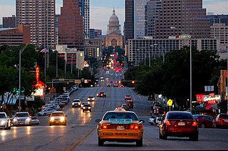
Congress Avenue is a major thoroughfare in Austin, Texas. The street is a six-lane, tree lined avenue that cuts through the middle of the city from far south Austin and goes over Lady Bird Lake leading to the Texas State Capitol in the heart of Downtown.

Oakwood Cemetery, originally called City Cemetery, is the oldest city-owned cemetery in Austin, Texas. Situated on a hill just east of I-35 that overlooks downtown Austin, just north of the Swedish Hill Historic District and south of Disch-Falk Field, the once-isolated site is now in the center of the city.

The Old West Austin Historic District is a residential community in Austin, Texas, United States. It is composed of three neighborhoods located on a plateau just west of downtown Austin: Old Enfield, Pemberton Heights, and Bryker Woods. Developed between 1886 and 1953, the three historic neighborhoods stretch from Mopac Expressway east to Lamar Boulevard, and from 13th Street north to 35th Street. It borders Clarksville Historic District and the West Line Historic District to the south.

The French Legation is a historic legation building in eastern Austin, Texas, built in 1841 to represent the French government in the new Republic of Texas.

The Austin History Center is the local history collection of the Austin Public Library and the city's historical archive.

The recorded history of Austin, Texas, began in the 1830s when Anglo-American settlers arrived in Central Texas. In 1837 settlers founded the village of Waterloo on the banks of the Colorado River, the first permanent settlement in the area. By 1839, Waterloo would adopt the name Austin and become the capital of the Republic of Texas.
James Riely Gordon was an architect who practiced in San Antonio until 1902 and then in New York City, where he gained national recognition. J. Riely Gordon is best known for his landmark county courthouses, in particular those in Texas. Working during the state's "Golden Age" (1883–1898) of courthouse construction, Gordon saw 18 of his designs erected from 1885 to 1901; today 12 remain.

The Lamar Boulevard Bridge is a historic arch bridge carrying Texas State Highway Loop 343 over Lady Bird Lake in downtown Austin, Texas, United States. The bridge features six open-spandrel concrete arches spanning 659 feet (201 m) and carries tens of thousands of vehicles daily across the lake. Completed in 1942, the Lamar Boulevard Bridge was the second permanent bridge to cross the Colorado River, and one of the last Art Deco-style open-spandrel concrete arch bridges built in Texas. The bridge was named an Austin Landmark in 1993 and added to the National Register of Historic Places in 1994.

Downtown Austin is the central business district of Austin, Texas. Downtown is located on the north bank of the Colorado River. The approximate borders of Downtown include Lamar Boulevard to the west, Martin Luther King Jr. Boulevard and the University of Texas at Austin to the north, Interstate 35 to the east, and Lady Bird Lake to the south.

Alfred Charles Finn was an American architect. He started in the profession with no formal training in 1904 as an apprentice for Sanguinet & Staats. He worked in their offices in Dallas, Fort Worth, and Houston. His credits during his tenure residential structures, but firm was a leader in steel-frame construction of skyscrapers.

Gethsemane Lutheran Church is a historic Lutheran church in downtown Austin, Texas. Designated as a Recorded Texas Historic Landmark and listed on the National Register of Historic Places, the building currently holds offices of the Texas Historical Commission.

The Westgate Tower is a mixed-use high-rise building in downtown Austin, Texas. The twenty-six-story 261-foot (80 m) tower block was designed in 1962 and completed in 1966; its name reflects its location across the street from the west gate of the Texas State Capitol. Designed by architect Edward Durell Stone, the tower was added to the National Register of Historic Places in 2010 and designated a Recorded Texas Historic Landmark in 2012.

The Capitol View Corridors are a series of legal restrictions on construction in Austin, Texas, aimed at preserving protected views of the Texas State Capitol from various points around the city. First established by the Texas Legislature in 1983 and recodified in 2001, the corridors are meant to protect the capitol dome from obstruction by high-rise buildings. While supported by cultural and historical preservation organizations, the corridors have also been criticized for limiting the potential for the development of new tall structures in downtown Austin.

The West Fifth Street Bridge is a historic cantilever concrete girder bridge in downtown Austin, Texas. Built in 1931, the bridge carries Fifth Street across Shoal Creek to link central Austin with neighborhoods that were then the city's western suburbs. It is one of only a handful of curved cantilever girder bridges in Texas, built as part of the city's 1928 master plan for urban development and beautification. The bridge was added to the National Register of Historic Places in 2019.

The Town Lake Gazebo is a historic gazebo on the south shore of Lady Bird Lake in Austin, Texas, beside Auditorium Shores. Built in 1969 to beautify the south shore of Lady Bird Lake, the gazebo was paid for by the National Association of Women in Construction and features eclectic architecture. The structure was listed on the National Register of Historic Places in 2020.

The 1839 Austin city plan is the original city plan for the development of Austin, Texas, which established the grid plan for what is now downtown Austin. It was commissioned in 1839 by the government of the Republic of Texas and developed by Edwin Waller, a Texian revolutionary and politician who would later become Austin's first mayor.
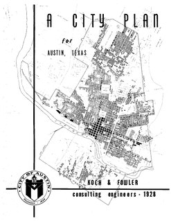
The 1928 Austin city plan was commissioned in 1927 by the City Council of Austin, Texas. It was developed by consulting firm Koch & Fowler, which presented the final proposal early the next year. The major recommendations of this city plan related to Austin's street plan, its zoning code, and the development of major industries and civic features, but it is most remembered for institutionalizing housing segregation by designating East Austin as the city's negro district.

