Balbalan

Last updated
Balbalan
Municipality of Balbalan
Flag of Balbalan, Kalinga.png
Ph locator kalinga balbalan.png
Map of Kalinga with Balbalan highlighted
OpenStreetMap
Balbalan
Philippines location map (square).svg
Red pog.svg
Balbalan
Location within the Philippines
Coordinates: 17°26′37″N121°12′03″E / 17.4436°N 121.2008°E / 17.4436; 121.2008
Country Philippines
Region Cordillera Administrative Region
Province Kalinga
District Lone district
Barangays 14 (see Barangays)
Government
[1]
  Type Sangguniang Bayan
   Mayor Almar P. Malannag
   Vice Mayor Rowina Alison Munda C. Damian
   Representative Allen Jesse C. Mangaoang
   Municipal Council
Members
   Electorate 9,602 voters (2022)
Area
[2]
  Total542.69 km2 (209.53 sq mi)
Elevation
1,067 m (3,501 ft)
Highest elevation
2,077 m (6,814 ft)
Lowest elevation
308 m (1,010 ft)
Population
 (2020 census) [3]
  Total12,914
  Density24/km2 (62/sq mi)
   Households
2,528
Economy
   Income class 3rd municipal income class
   Poverty incidence
15.95
% (2018) [4]
   Revenue 182.2 million (2020)
   Assets 350.3 million (2020)
   Expenditure 115.7 million (2020)
   Liabilities 105.4 million (2020)
Service provider
  ElectricityKalinga - Apayao Electric Cooperative (KAELCO)
Time zone UTC+8 (PST)
ZIP code
3801
PSGC
IDD : area code +63(0)74
Native languages Kalinga
Ilocano
Tagalog
Website www.balbalan.gov.ph

Balbalan, officially the Municipality of Balbalan is a 3rd class municipality in the province of Kalinga, Philippines. According to the 2020 census, it has a population of 12,914 people. [3]

Contents

History

Early beginning

This town draws its name from an ancient practice. It was said that war parties coming from certain areas in northern Kalinga (probably, the ancient place of Salegseg) used to meet by a creek when mapping out their plan of attack against or when regrouping after attacking a certain village. Since they would always wash (balbal, in the local dialect) their blood-stained bodies and weapons in the creek, the place and its adjacent areas came to be known as Balbalan. Since its violent history, Balbalan has become one of the most peaceful places in Kalinga as dramatized by the selection of one of its ethnic sub-groups, the Salegseg.

Spanish Era

The Spaniards made at least 10 incursions [nb 1] into the land of the Kalingas from the early 1600s to the late 1800s, four of which were made from the west (Abra) primarily targeting the regions of Banao and Guinaang. [5] Although they succeeded around the mid-1800s in establishing a telegraph station in Balbalasang (where, incidentally, they appointed the noted Banao leader Juan Puyao as a gobernadorcillo or councilor) and subsequently hacking out an Ilocos-Abra-Kalinga-Cagayan trail, they failed to establish a foothold in Kalinga. [6]

Prior to the establishment of American rule in Kalinga, the ethnic sub-groups covered by the present geopolitical configuration of Balbalan were, like other Kalinga communities at that time, organized according to an indigenous system or concept of local governance operating within a “bilateral kinship group” circumscribed by semi-permanent territorial boundary. [nb 2] [7]

This period saw the rise of several community leaders often mentioned in Balbalan orature: Sagaoc, Balutoc, Masadao, Gaddawan, Dawegoy, Lang-ayan, Bayudang, Gammong, et al.

American Era

When the Americans imposed their system of government over the archipelago, the land of the Kalingas became one of the highlights of their so-called “pacification campaign.” On 18 August 1907, Kalinga, then a sub-province of Lepanto-Bontoc, came under the control of Lt. Gov. Walter Franklin Hale who established his seat of government in Lubuagan where he organized the sub-province into four districts: Tinglayan-Tanudan; Balbalan-Pasil; Pinukpuk-Tobog (Tabuk), and Liwan (Rizal). [8]

A year later, Act 1870 of the Philippine Commission carved the old Mountain Province out of northern Luzon with Kalinga as one of its five sub-provinces. Kalinga was immediately reorganized into five municipal districts — Lubuagan (including Tanudan and Pasil), Balbalan (including Balinciagao), Tabuk (with Liwan or Rizal), Tinglayan, and Pinukpuk — each led by presidents. Among these municipal chiefs was Puyao [nb 3] who served in that capacity for close to 24 years under five subprovincial chief executives: Walter F. Hale (1907–1915), Alex F. Gilfilan (1915), Samuel E. Kane (1915–1919), Tomas Blanco (1918–1923), and Nicasio Balinag (1923–1936). Puyao did not run for office during the first local elections in the area in 1934, and was succeeded by Awingan. Three years later, municipal chief executives became known as “Municipal District Mayors.” [9]

In 1942 a Japanese garrison was established in Balbalan.

Post-War Era

The old Mountain Province was regularized as a “first class province” in 1959 and new local elections were subsequently held. In Balbalan, Pedro Sagalon was elected mayor (Sugguiyao, 23). From 1988 to the present, government records list the following as mayors: Leonardo Banganan (1988–1992), Edward Calumnag (1992–1995), Rosendo Dakiwag (1995–2001), and Allen J.C. Mangaoang (2001 to 2013).

The present leadership of Balbalan has special significance to those who feared that the death of Juan Puyao in 1948 meant the end of his political bloodline. In the words of Kalinga historian Miguel Sugguiyao (1990, 39):

The late Juan Puyao was not only recognized as a prominent leader in his own Balbalan corner but also in the whole Kalinga as well as the whole undivided Mountain Province. Since his demise in 1948 to the present (1982) no one among the descendants of the late Ex-President Juan Puyao has gained the limelight in Kalinga leadership.

Geography

Barangays

Balbalan is politically subdivided into 14 barangays. Each barangay consists of puroks and some have sitios.

  • Ababa-an
  • Balantoy
  • Balbalan Proper
  • Balbalasang
  • Buaya
  • Dao-angan
  • Gawa-an
  • Mabaca
  • Maling (Kabugao)
  • Pantikian
  • Poswoy
  • Poblacion (Salegseg)
  • Talalang
  • Tawang

Climate

Climate data for Balbalan, Kalinga
MonthJanFebMarAprMayJunJulAugSepOctNovDecYear
Mean daily maximum °C (°F)20
(68)
21
(70)
24
(75)
26
(79)
26
(79)
26
(79)
25
(77)
24
(75)
24
(75)
23
(73)
22
(72)
20
(68)
23
(74)
Mean daily minimum °C (°F)15
(59)
15
(59)
16
(61)
17
(63)
19
(66)
19
(66)
19
(66)
19
(66)
18
(64)
18
(64)
17
(63)
16
(61)
17
(63)
Average precipitation mm (inches)78
(3.1)
60
(2.4)
49
(1.9)
51
(2.0)
194
(7.6)
197
(7.8)
209
(8.2)
226
(8.9)
185
(7.3)
180
(7.1)
143
(5.6)
183
(7.2)
1,755
(69.1)
Average rainy days15.612.511.812.521.023.325.226.122.617.116.719.6224
Source: Meteoblue [10]

Demographics

Population census of Balbalan
YearPop.±% p.a.
1918 6,238    
1939 5,670−0.45%
1948 6,184+0.97%
1960 7,605+1.74%
1970 6,518−1.53%
1975 7,552+3.00%
1980 9,168+3.95%
1990 10,147+1.02%
1995 11,742+2.77%
2000 11,934+0.35%
2007 12,012+0.09%
2010 12,082+0.21%
2015 12,195+0.18%
2020 12,914+1.13%
Source: Philippine Statistics Authority [11] [12] [13] [14]

In the 2020 census, the population of Balbalan was 12,914 people, [3] with a density of 24 inhabitants per square kilometre or 62 inhabitants per square mile.

Economy

Government

Local government

Balbalan, belonging to the lone congressional district of the province of Kalinga, is governed by a mayor designated as its local chief executive and by a municipal council as its legislative body in accordance with the Local Government Code. The mayor, vice mayor, and the councilors are elected directly by the people through an election which is being held every three years.

Elected officials

Members of the Municipal Council
(2019–2022) [22]
PositionName
CongressmanAllen Jesse C. Mangaoang
MayorEric L. Gonayon
Vice-MayorWinifredo B. Agapito
CouncilorsAlmar P. Malannag
Edwin Bruce B. Astudillo
Cerillo B. Tega Jr.
Rex L. Dulansi
Paul B. Bogacon
Dennis C. Baggas
Bernabe C. Basingan
Abraham T. Aromin

See also

Notes

  1. In The Kalinga Hilltribe of the Philippines (1990, 13-15), Sugguiyao lists three, but a comparative study of available documents as cited reveals more than that number.
  2. Barton referred to these territories as “regions,” which is perhaps roughly equivalent to what the German traveler Alexander Schadenberg (1886) called “province,” as in “Banao province” (Scott 1975, 131). Note, however, that, according to Scott in another work (1974, 313), there was no such village as Banao, although “people from Inalangan down the Saltan River to Salegseg referred to themselvfes as Banao people.” Schadenberg also mentioned a “Chief Liagao” in the rancheria of Balbalasang (Scott 1975, 133).
  3. Along with Lubuagan Presidente Antonio Canao, Puyao’s peerless leadership and his contribution to the success of American rule in Kalinga prompted then Congressman of the old Mountain Province Alfredo Lam-en to file a bill seeking to rename Balbalan and Lubuagan “Puyao” and “Canao,” respectively (Finin 2005, 194).

Related Research Articles

<span class="mw-page-title-main">Kalinga (province)</span> Province in Cordillera, Philippines

Kalinga, officially the Province of Kalinga, is a landlocked province in the Philippines situated within the Cordillera Administrative Region in Luzon. Its capital is Tabuk and borders Mountain Province to the south, Abra to the west, Isabela to the east, Cagayan to the northeast, and Apayao to the north. Kalinga and Apayao are the result of the 1995 partitioning of the former province of Kalinga-Apayao which was seen to better service the respective needs of the various indigenous peoples in the area.

<span class="mw-page-title-main">Cordillera Administrative Region</span> Administrative region of the Philippines

The Cordillera Administrative Region, also known as the Cordillera Region and Cordillera, is an administrative region in the Philippines, situated within the island of Luzon. It is the only landlocked region in the insular country, bordered by the Ilocos Region to the west and southwest, and by the Cagayan Valley Region to the north, east, and southeast. It is the least populous region in the Philippines, with a population less than that of the city of Manila.

<span class="mw-page-title-main">Igorot people</span> Ethnic group in the Philippines

The indigenous peoples of the Cordillera in northern Luzon, Philippines, often referred to by the exonym Igorot people, or more recently, as the Cordilleran peoples, are an ethnic group composed of nine main ethnolinguistic groups whose domains are in the Cordillera Mountain Range, altogether numbering about 1.8 million people in the early 21st century.

<span class="mw-page-title-main">Bauko</span> Municipality in Mountain Province, Philippines

Bauko, officially the Municipality of Bauko is a 4th class municipality in the province of Mountain Province, Philippines. According to the 2020 census, it has a population of 32,021 people.

<span class="mw-page-title-main">Boliney</span> Municipality in Abra, Philippines

Boliney, officially the Municipality of Boliney, is a 5th class municipality in the province of Abra, Philippines. According to the 2020 census, it has a population of 4,551 people.

<span class="mw-page-title-main">Malibcong</span> Municipality in Abra, Philippines

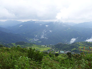
Malibcong, officially the Municipality of Malibcong, is a 5th class municipality in the province of Abra, Philippines. According to the 2020 census, it has a population of 4,027 people.

<span class="mw-page-title-main">La Trinidad, Benguet</span> Capital of Benguet, Philippines

La Trinidad, officially the Municipality of La Trinidad, is a 1st class municipality and capital of the province of Benguet, Philippines. According to the 2020 census, it has a population of 137,404 people.

<span class="mw-page-title-main">Barlig</span> Municipality in Mountain Province, Philippines

Barlig, officially the Municipality of Barlig is a 5th class municipality in the province of Mountain Province, Philippines. According to the 2020 census, it has a population of 4,796 people.

<span class="mw-page-title-main">Natonin</span> Municipality in Mountain Province, Philippines

Natonin, officially the Municipality of Natonin, is a 4th class municipality in the province of Mountain Province, Philippines. According to the 2020 census, it has a population of 10,339 people.

<span class="mw-page-title-main">Sabangan</span> Municipality in Mountain Province, Philippines

Sabangan, officially the Municipality of Sabangan is a 5th class municipality in the province of Mountain Province, Philippines. According to the 2020 census, it has a population of 9,621 people.

<span class="mw-page-title-main">Sagada</span> Municipality in Mountain Province, Philippines


Sagada, officially the Municipality of Sagada is a 5th class municipality in the province of Mountain Province, Philippines. According to the 2020 census, it has a population of 11,510 people.

<span class="mw-page-title-main">Lubuagan</span> Municipality in Kalinga, Philippines

Lubuagan, officially the Municipality of Lubuagan is a 4th class municipality in the province of Kalinga, Philippines. According to the 2020 census, it has a population of 9,323 people.

<span class="mw-page-title-main">Pasil</span> Municipality in Kalinga, Philippines

Pasil, officially the Municipality of Pasil, is a 5th class municipality in the southwestern part of the Kalinga. It is bounded on the north by the municipality of Balbalan, on the south by the municipality of Tinglayan, on the east by Tabuk city, and on the west by the province of Abra and south-western part of the municipality of Sadanga, Mountain Province. According to the 2020 census, it has a population of 10,577 people.

<span class="mw-page-title-main">Pinukpuk</span> Municipality in Kalinga, Philippines

Pinukpuk, officially the Municipality of Pinukpuk is a 1st class municipality in the province of Kalinga, Philippines. According to the 2020 census, it has a population of 34,275 people.

<span class="mw-page-title-main">Tabuk, Kalinga</span> Capital of Kalinga, Philippines

Tabuk, officially the City of Tabuk, is a 5th class component city and capital of the province of Kalinga, Philippines. According to the 2020 census, it has a population of 121,033 people.

<span class="mw-page-title-main">Tanudan</span> Municipality in Kalinga, Philippines

Tanudan, officially the Municipality of Tanudan is a 4th class municipality in the province of Kalinga, Philippines. According to the 2020 census, it has a population of 8,746 people.

<span class="mw-page-title-main">Tinglayan</span> Municipality in Kalinga, Philippines

Tinglayan, officially the Municipality of Tinglayan is a 4th class municipality in the province of Kalinga, Philippines. According to the 2020 census, it has a population of 13,148 people.

<span class="mw-page-title-main">Atok, Benguet</span> Municipality in Benguet, Philippines

Atok, officially the Municipality of Atok,, is a 4th class municipality in the province of Benguet, Philippines. According to the 2020 census, it has a population of 19,218 people.

<span class="mw-page-title-main">Itogon</span> Municipality in Benguet, Philippines

Itogon, officially the Municipality of Itogon,, is a 1st class municipality in the province of Benguet, Philippines. According to the 2020 census, it has a population of 61,498 people.

<span class="mw-page-title-main">Sablan, Benguet</span> Municipality in Benguet, Philippines

Sablan, officially the Municipality of Sablan, is a 5th class municipality in the province of Benguet, Philippines. According to the 2020 census, it has a population of 11,588 people.

References

  1. Municipality of Balbalan | (DILG)
  2. "2015 Census of Population, Report No. 3 – Population, Land Area, and Population Density" (PDF). Philippine Statistics Authority. Quezon City, Philippines. August 2016. ISSN   0117-1453. Archived (PDF) from the original on May 25, 2021. Retrieved July 16, 2021.
  3. 1 2 3 Census of Population (2020). "Cordillera Administrative Region (CAR)". Total Population by Province, City, Municipality and Barangay. Philippine Statistics Authority . Retrieved 8 July 2021.
  4. "PSA Releases the 2018 Municipal and City Level Poverty Estimates". Philippine Statistics Authority. 15 December 2021. Retrieved 22 January 2022.
  5. Scott 1974, 2; Bacdayan 1967, 17; Lawless 1975, 43-45
  6. cf. Scott 1974, 249; Sugguiyao 1990, 15; Bacdayan, 17-18; Dozier 1966, 29-32
  7. Barton 1949, 32; cf. Dozier 1967, 12 f; Sugguiyao, 4.
  8. Sugguiyao, 16
  9. De Los Reyes 1986, 28; Sugguiyao, 22; Jenista, 70,259
  10. "Balbalan: Average Temperatures and Rainfall". Meteoblue. Retrieved 8 March 2020.
  11. Census of Population (2015). "Cordillera Administrative Region (CAR)". Total Population by Province, City, Municipality and Barangay. Philippine Statistics Authority . Retrieved 20 June 2016.
  12. Census of Population and Housing (2010). "Cordillera Administrative Region (CAR)" (PDF). Total Population by Province, City, Municipality and Barangay. National Statistics Office . Retrieved 29 June 2016.
  13. Censuses of Population (1903–2007). "Cordillera Administrative Region (CAR)". Table 1. Population Enumerated in Various Censuses by Province/Highly Urbanized City: 1903 to 2007. National Statistics Office.{{cite encyclopedia}}: CS1 maint: numeric names: authors list (link)
  14. "Province of Kalinga". Municipality Population Data. Local Water Utilities Administration Research Division. Retrieved 17 December 2016.
  15. "Poverty incidence (PI):". Philippine Statistics Authority. Retrieved December 28, 2020.
  16. "Estimation of Local Poverty in the Philippines" (PDF). Philippine Statistics Authority. 29 November 2005.
  17. "2003 City and Municipal Level Poverty Estimates" (PDF). Philippine Statistics Authority. 23 March 2009.
  18. "City and Municipal Level Poverty Estimates; 2006 and 2009" (PDF). Philippine Statistics Authority. 3 August 2012.
  19. "2012 Municipal and City Level Poverty Estimates" (PDF). Philippine Statistics Authority. 31 May 2016.
  20. "Municipal and City Level Small Area Poverty Estimates; 2009, 2012 and 2015". Philippine Statistics Authority. 10 July 2019.
  21. "PSA Releases the 2018 Municipal and City Level Poverty Estimates". Philippine Statistics Authority. 15 December 2021. Retrieved 22 January 2022.
  22. "2019 National and Local Elections" (PDF). Commission on Elections. Retrieved March 13, 2022.

Works cited

Books
Periodicals