Pinukpuk

Last updated
Pinukpuk
Municipality of Pinukpuk
Flag of Pinukpuk, Kalinga.png
Ph locator kalinga pinukpuk.png
Map of Kalinga with Pinukpuk highlighted
OpenStreetMap
Pinukpuk
Philippines location map (square).svg
Red pog.svg
Pinukpuk
Location within the Philippines
Coordinates: 17°34′23″N121°21′55″E / 17.5731°N 121.3653°E / 17.5731; 121.3653
Country Philippines
Region Cordillera Administrative Region
Province Kalinga
District Lone district
Barangays 23 (see Barangays)
Government
[1]
  Type Sangguniang Bayan
   Mayor Irving B. Dasayon
   Vice Mayor Jimmy B. Dasayon
   Representative Allen Jesse C. Mangaoang
   Municipal Council
Members
   Electorate 21,254 voters (2022)
Area
[2]
  Total743.56 km2 (287.09 sq mi)
Elevation
257 m (843 ft)
Highest elevation
636 m (2,087 ft)
Lowest elevation
74 m (243 ft)
Population
 (2020 census) [3]
  Total34,275
  Density46/km2 (120/sq mi)
   Households
7,290
Economy
   Income class 1st municipal income class
   Poverty incidence
20.31
% (2018) [4]
   Revenue 257.9 million (2020)
   Assets 693.1 million (2020)
   Expenditure 129.6 million (2020)
   Liabilities 84.13 million (2020)
Service provider
  ElectricityKalinga - Apayao Electric Cooperative (KAELCO)
Time zone UTC+8 (PST)
ZIP code
3806
PSGC
IDD : area code +63(0)74
Native languages Kalinga
Ilocano
Tagalog
Website www.pinukpuk.gov.ph

Pinukpuk, officially the Municipality of Pinukpuk is a 1st class municipality in the province of Kalinga, Philippines. According to the 2020 census, it has a population of 34,275 people. [3]

Contents

Pinukpuk is in the northern part of Kalinga province, which is a gateway to Tuao, Cagayan, and Conner, Apayao. It is 31 kilometres (19 mi) from Tabuk City and 523 kilometres (325 mi) from Manila.

History

Pinukpuk, while being a municipal district, reduced its territories when Governor-General Leonard Wood issued executive orders transferring barrios of Mabaca, Buaya, and Canna to Balbalan (EO No. 16; issued on June 23, 1926 and effective July 1), as well as Barrio Puguin and sitios of Umnay, Bauban, and Daga to Conner in the sub-province of Apayao (EO No. 55; issued on March 19, 1927 and effective April 1). [5]

Geography

Barangays

Pinukpuk is politically subdivided into 23 barangays. [6] Each barangay consists of puroks and some have sitios.

  • Aciga
  • Allaguia
  • Ammacian
  • Apatan
  • Asibanglan
  • Ba-ay
  • Ballayangon
  • Bayao
  • Camalog (formerly Camcamalog)
  • Cawagayan (formerly Cagao-ayan) [The first Barangay From Tabuk in the Western part of the Chico River.]
  • Dugpa
  • Katabbogan
  • Limos
  • Magaogao
  • Malagnat
  • Mapaco
  • Pakawit
  • Pinococ
  • Pinukpuk Junction -Center
  • Socbot [First Barangay from Tabuk in the Eastern part of Chico River]
  • Taga (Poblacion)
  • Taggay
  • Wagud

Climate

Climate data for Pinukpuk, Kalinga
MonthJanFebMarAprMayJunJulAugSepOctNovDecYear
Mean daily maximum °C (°F)26
(79)
27
(81)
29
(84)
32
(90)
32
(90)
31
(88)
31
(88)
30
(86)
30
(86)
29
(84)
27
(81)
26
(79)
29
(85)
Mean daily minimum °C (°F)20
(68)
21
(70)
22
(72)
23
(73)
24
(75)
25
(77)
24
(75)
25
(77)
24
(75)
23
(73)
23
(73)
21
(70)
23
(73)
Average precipitation mm (inches)109
(4.3)
78
(3.1)
64
(2.5)
54
(2.1)
181
(7.1)
196
(7.7)
204
(8.0)
211
(8.3)
174
(6.9)
198
(7.8)
185
(7.3)
231
(9.1)
1,885
(74.2)
Average rainy days17.213.713.213.021.723.425.225.221.917.718.620.8231.6
Source: Meteoblue [7]

Demographics

Population census of Pinukpuk
YearPop.±% p.a.
1918 5,397    
1939 4,353−1.02%
1948 4,612+0.64%
1960 7,030+3.57%
1970 10,470+4.06%
1975 11,557+2.00%
1980 17,362+8.48%
1990 20,102+1.48%
1995 23,057+2.60%
2000 26,130+2.72%
2007 27,783+0.85%
2010 29,596+2.33%
2015 32,026+1.51%
2020 34,275+1.34%
Source: Philippine Statistics Authority [8] [9] [10] [11]

In the 2020 census, the population of Pinukpuk was 34,275 people, [3] with a density of 46 inhabitants per square kilometre or 120 inhabitants per square mile.

Economy

Government

Local government

Pinukpuk, belonging to the lone congressional district of the province of Kalinga, is governed by a mayor designated as its local chief executive and by a municipal council as its legislative body in accordance with the Local Government Code. The mayor, vice mayor, and the councilors are elected directly by the people through an election which is being held every three years.

Elected officials

Members of the Municipal Council
(2019–2022) [19]
PositionName
CongressmanAllen Jesse C. Mangaoang
MayorIrving B. Dasayon
Vice-MayorJimmy B. Dasayon
CouncilorsBernadette P. Cabannag
Janice Grace B. Catriz-Tuddao
Lolito A. Iddoba
Dominador M. Lagayon
Hilaria L. Balagso
Gavino Dolnagon
Celestino L. Dong-as Sr.
Froilan P. Belac

Education

List of National High Schools

As of July, 2021, Pinukpuk has 10 Secondary Schools. [20]

Related Research Articles

<span class="mw-page-title-main">Apayao</span> Province in Cordillera, Philippines

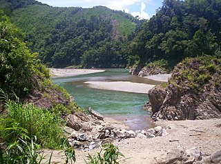
Apayao, officially the Province of Apayao, is a landlocked province in the Philippines in the Cordillera Administrative Region in Luzon. Kabugao serves as its capital. The provincial capitol and its associated offices are located at the New Government Center in Luna.

<span class="mw-page-title-main">Kalinga (province)</span> Province in Cordillera, Philippines

Kalinga, officially the Province of Kalinga, is a landlocked province in the Philippines situated within the Cordillera Administrative Region in Luzon. Its capital is Tabuk and borders Mountain Province to the south, Abra to the west, Isabela to the east, Cagayan to the northeast, and Apayao to the north. Kalinga and Apayao are the result of the 1995 partitioning of the former province of Kalinga-Apayao which was seen to better service the respective needs of the various indigenous peoples in the area.

<span class="mw-page-title-main">Cordillera Administrative Region</span> Administrative region of the Philippines

The Cordillera Administrative Region, also known as the Cordillera Region and Cordillera, is an administrative region in the Philippines, situated within the island of Luzon. It is the only landlocked region in the insular country, bordered by the Ilocos Region to the west and southwest, and by the Cagayan Valley Region to the north, east, and southeast. It is the least populous region in the Philippines, with a population less than that of the city of Manila.

<span class="mw-page-title-main">Luna, Apayao</span> Municipality in Apayao, Philippines

Luna, officially the Municipality of Luna, is a 2nd class municipality in the province of Apayao, Philippines. According to the 2020 census, it has a population of 21,297 people. It currently serves as the de facto capital of Apayao where the provincial capitol and related offices is located the New Apayao Government Center. Kabugao remains as the de jure capital.

<span class="mw-page-title-main">Santa Marcela, Apayao</span> Municipality in Apayao, Philippines

Santa Marcela, officially the Municipality of Santa Marcela, is a 4th class municipality in the province of Apayao, Philippines. According to the 2020 census, it has a population of 13,317 people.

<span class="mw-page-title-main">Abulug</span> Municipality in Cagayan, Philippines

Abulug, officially the Municipality of Abulug, is a 3rd class municipality in the province of Cagayan, Philippines. According to the 2020 census, it has a population of 34,579 people.

<span class="mw-page-title-main">Santa Praxedes, Cagayan</span> Municipality in Cagayan, Philippines

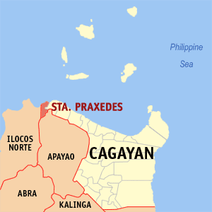
Santa Praxedes, officially the Municipality of Santa Praxedes, is a 5th class municipality in the province of Cagayan, Philippines. According to the 2020 census, it has a population of 4,434 people.

<span class="mw-page-title-main">Paracelis</span> Municipality in Mountain Province, Philippines

Paracelis, officially the Municipality of Paracelis is a 2nd class municipality in the province of Mountain Province, Philippines. According to the 2020 census, it has a population of 31,168 people.

<span class="mw-page-title-main">Calanasan</span> Municipality in Apayao, Philippines

Calanasan, officially the Municipality of Calanasan,, is a 1st class municipality in the province of Apayao, Philippines. According to the 2020 census, it has a population of 12,550 people.

<span class="mw-page-title-main">Conner, Apayao</span> Municipality in Apayao, Philippines

Conner, officially the Municipality of Conner,, is a 2nd class municipality in the province of Apayao, Philippines. According to the 2020 census, it has a population of 27,552 people.

<span class="mw-page-title-main">Flora, Apayao</span> Municipality in Apayao, Philippines

Flora, officially the Municipality of Flora, is a 3rd class municipality in the province of Apayao, Philippines. According to the 2020 census, it has a population of 17,944 people.

<span class="mw-page-title-main">Kabugao</span> Capital of Apayao, Philippines

Kabugao, officially the Municipality of Kabugao, is a 1st class municipality and de jure capital of the province of Apayao, Philippines. According to the 2020 census, it has a population of 16,215 people.

<span class="mw-page-title-main">Balbalan</span> Municipality in Kalinga, Philippines

Balbalan, officially the Municipality of Balbalan is a 3rd class municipality in the province of Kalinga, Philippines. According to the 2020 census, it has a population of 12,914 people.

<span class="mw-page-title-main">Lubuagan</span> Municipality in Kalinga, Philippines

Lubuagan, officially the Municipality of Lubuagan is a 4th class municipality in the province of Kalinga, Philippines. According to the 2020 census, it has a population of 9,323 people.

<span class="mw-page-title-main">Pasil</span> Municipality in Kalinga, Philippines

Pasil, officially the Municipality of Pasil, is a 5th class municipality in the southwestern part of the Kalinga. It is bounded on the north by the municipality of Balbalan, on the south by the municipality of Tinglayan, on the east by Tabuk city, and on the west by the province of Abra and south-western part of the municipality of Sadanga, Mountain Province. According to the 2020 census, it has a population of 10,577 people.

<span class="mw-page-title-main">Tabuk, Kalinga</span> Capital of Kalinga, Philippines

Tabuk, officially the City of Tabuk, is a 5th class component city and capital of the province of Kalinga, Philippines. According to the 2020 census, it has a population of 121,033 people.

<span class="mw-page-title-main">Tinglayan</span> Municipality in Kalinga, Philippines

Tinglayan, officially the Municipality of Tinglayan is a 4th class municipality in the province of Kalinga, Philippines. According to the 2020 census, it has a population of 13,148 people.

<span class="mw-page-title-main">Atok, Benguet</span> Municipality in Benguet, Philippines

Atok, officially the Municipality of Atok,, is a 4th class municipality in the province of Benguet, Philippines. According to the 2020 census, it has a population of 19,218 people.

<span class="mw-page-title-main">Bakun, Benguet</span> Municipality in Benguet, Philippines

Bakun, officially the Municipality of Bakun,, is a 3rd class municipality in the province of Benguet, Philippines. According to the 2020 census, it has a population of 14,535 people.

<span class="mw-page-title-main">Kapangan</span> Municipality in Benguet, Philippines

Kapangan, officially the Municipality of Kapangan,, is a 4th class municipality in the province of Benguet, Philippines. According to the 2020 census, it has a population of 19,297 people.

References

  1. Municipality of Pinukpuk | (DILG)
  2. "2015 Census of Population, Report No. 3 – Population, Land Area, and Population Density" (PDF). Philippine Statistics Authority. Quezon City, Philippines. August 2016. ISSN   0117-1453. Archived (PDF) from the original on May 25, 2021. Retrieved July 16, 2021.
  3. 1 2 3 Census of Population (2020). "Cordillera Administrative Region (CAR)". Total Population by Province, City, Municipality and Barangay. Philippine Statistics Authority . Retrieved 8 July 2021.
  4. "PSA Releases the 2018 Municipal and City Level Poverty Estimates". Philippine Statistics Authority. 15 December 2021. Retrieved 22 January 2022.
  5. "Index to Official Gazette (1913–1928)" (PDF). University of San Carlos . The Library Corporation. 2011–2012. Retrieved 2022-07-31.
    Executive Order 16 (1926): Executive Orders, 1926. Manila: Bureau of Printing. 1927. pp. 27–29. Retrieved 2022-08-03.
    Executive Order 55 (1927): Executive Orders, 1927. Manila: Bureau of Printing. 1928. pp. 26–27. Retrieved 2022-08-03.
  6. "Province: Kalinga". PSGC Interactive. Quezon City, Philippines: Philippine Statistics Authority . Retrieved 12 November 2016.
  7. "Pinukpuk: Average Temperatures and Rainfall". Meteoblue. Retrieved 8 March 2020.
  8. Census of Population (2015). "Cordillera Administrative Region (CAR)". Total Population by Province, City, Municipality and Barangay. Philippine Statistics Authority . Retrieved 20 June 2016.
  9. Census of Population and Housing (2010). "Cordillera Administrative Region (CAR)" (PDF). Total Population by Province, City, Municipality and Barangay. National Statistics Office . Retrieved 29 June 2016.
  10. Censuses of Population (1903–2007). "Cordillera Administrative Region (CAR)". Table 1. Population Enumerated in Various Censuses by Province/Highly Urbanized City: 1903 to 2007. National Statistics Office.{{cite encyclopedia}}: CS1 maint: numeric names: authors list (link)
  11. "Province of Kalinga". Municipality Population Data. Local Water Utilities Administration Research Division. Retrieved 17 December 2016.
  12. "Poverty incidence (PI):". Philippine Statistics Authority. Retrieved December 28, 2020.
  13. "Estimation of Local Poverty in the Philippines" (PDF). Philippine Statistics Authority. 29 November 2005.
  14. "2003 City and Municipal Level Poverty Estimates" (PDF). Philippine Statistics Authority. 23 March 2009.
  15. "City and Municipal Level Poverty Estimates; 2006 and 2009" (PDF). Philippine Statistics Authority. 3 August 2012.
  16. "2012 Municipal and City Level Poverty Estimates" (PDF). Philippine Statistics Authority. 31 May 2016.
  17. "Municipal and City Level Small Area Poverty Estimates; 2009, 2012 and 2015". Philippine Statistics Authority. 10 July 2019.
  18. "PSA Releases the 2018 Municipal and City Level Poverty Estimates". Philippine Statistics Authority. 15 December 2021. Retrieved 22 January 2022.
  19. "2019 National and Local Elections" (PDF). Commission on Elections. Retrieved March 13, 2022.
  20. "List of Schools". Ebeis.deped.gov.ph. Retrieved 2022-08-28.