Bammel, Texas

Last updated

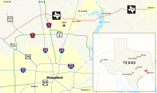
Bammel is an Unincorporated community in Harris County, Texas, United States.

Harris County, Texas County in the United States

Harris County is a county located in the U.S. state of Texas, located in the southeastern part of the state near Galveston Bay. As of the 2010 Census, the population was 4,092,459, making it the most populous county in Texas and the third most populous county in the United States. Its county seat is Houston, the largest city in Texas and fourth largest city in the United States. The county was founded in 1836 and organized in 1837. It is named for John Richardson Harris, who founded the town of Harrisburg on Buffalo Bayou in 1826. According to a July 2017 Census estimate, Harris County's population had grown to 4,652,980, comprising over 16 percent of Texas's population.

Texas State of the United States of America

Texas is the second largest state in the United States by both area and population. Geographically located in the South Central region of the country, Texas shares borders with the U.S. states of Louisiana to the east, Arkansas to the northeast, Oklahoma to the north, New Mexico to the west, and the Mexican states of Chihuahua, Coahuila, Nuevo León, and Tamaulipas to the southwest, while the Gulf of Mexico is to the southeast.

United States federal republic in North America

The United States of America (USA), commonly known as the United States or America, is a country composed of 50 states, a federal district, five major self-governing territories, and various possessions. At 3.8 million square miles, the United States is the world's third or fourth largest country by total area and is slightly smaller than the entire continent of Europe's 3.9 million square miles. With a population of over 327 million people, the U.S. is the third most populous country. The capital is Washington, D.C., and the largest city by population is New York City. Forty-eight states and the capital's federal district are contiguous in North America between Canada and Mexico. The State of Alaska is in the northwest corner of North America, bordered by Canada to the east and across the Bering Strait from Russia to the west. The State of Hawaii is an archipelago in the mid-Pacific Ocean. The U.S. territories are scattered about the Pacific Ocean and the Caribbean Sea, stretching across nine official time zones. The extremely diverse geography, climate, and wildlife of the United States make it one of the world's 17 megadiverse countries.

Contents

Bammel, eighteen miles north of downtown Houston at the intersection of Farm-to-Market Road 1960 (FM 1960) and Kuykendahl Road in north central Harris County, was established after the neighboring towns of Klein, Westfield, and Spring. It was named for Charles Bammel, a German Houstonian who built the Bammel and Kuehnle Merchandise store with his partner in 1915 and moved to the community for health reasons. A Bammel post office, at which Herman Kuehnle was the first postmaster, operated from 1916 until 1929. Bammel's store burned in 1927 but was later rebuilt to serve the new Bammel Forest subdivision. The town's population was reported as roughly fifty from 1929 until oil was discovered in the area in 1938. In 1943 the community reported two stores and a population of 200, but in 1949 its population was estimated at twenty. During the 1980s Bammel's residents were mainly commuters who worked in Houston. The community included two shopping centers, several schools, a hospital, and nearby cemeteries.

Houston City in Texas, United States

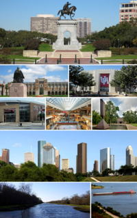
Houston is the most populous city in the U.S. state of Texas and the fourth most populous city in the United States, with a census-estimated population of 2.312 million in 2017. It is the most populous city in the Southern United States and on the Gulf Coast of the United States. Located in Southeast Texas near Galveston Bay and the Gulf of Mexico, it is the seat of Harris County and the principal city of the Greater Houston metropolitan area, which is the fifth most populous metropolitan statistical area (MSA) in the United States and the second most populous in Texas after the Dallas-Fort Worth MSA. With a total area of 627 square miles (1,620 km2), Houston is the eighth most expansive city in the United States. It is the largest city in the United States by total area, whose government is similarly not consolidated with that of a county or borough. Though primarily in Harris County, small portions of the city extend into Fort Bend and Montgomery counties.

Education

Spring Independent School District operates schools in the area.

Spring Independent School District

Spring Independent School District is a school district based in the Gordon M. Anderson Leadership Center in unincorporated Harris County, Texas, United States. It is located in north Harris County.

In the 1900s one school had 30 children taught by one teacher. The building was donated by a man named Mr. Harrell. A fire burned the building, and men from Spring helped rebuild the school. In 1900 a one-room school opened on the Bender Estate. One year later, it moved to Spring. [1]

Spring, Texas Census-designated place in Texas, United States

Spring is a census-designated place (CDP) within the extraterritorial jurisdiction of Houston in Harris County, Texas, United States, part of the Houston–The Woodlands–Sugar Land metropolitan area. The population was 54,298 at the 2010 census. While the name "Spring" is applied to a large area of northern Harris County and a smaller area of southern Montgomery County, the original town of Spring, now known as Old Town Spring, is located at the intersection of Spring-Cypress and Hardy roads and encompasses a relatively small area of perhaps 1 km2.

Economy

The Bammel Gas Storage facility is one of the largest underground reservoir storage facilities in North America and is strategically located on the HPL gas pipeline system. Its capabilities include 118 billion cubic feet (BCF) of storage. The Houston Ship Channel and Houston's gas distribution company are important markets for gas stored at the Bammel facility. The facility was purchased by American Electric Power from Enron in 2001. [2]

Related Research Articles

Needville, Texas City in Texas, United States

Needville is a city in Fort Bend County, Texas, United States. It is within the Houston–Sugar Land metropolitan area. The population was 2,823 at the 2010 census.

Atascocita, Texas Census-designated place in Texas, United States

Atascocita is a census-designated place (CDP) in an unincorporated area within Harris County, Texas, United States within the Houston metropolitan area. As of the 2010 census it had a population of 65,569. It is located north and south of Farm to Market Road 1960 about 6 miles (10 km) east of Humble and 18 miles (29 km) northeast of downtown Houston in northeastern Harris County.

Crosby, Texas Census-designated place in Texas, United States

Crosby is a census-designated place in Harris County, Texas, United States. The population was 2,299 at the 2010 census.

Hunters Creek Village, Texas City in Texas, United States

Hunters Creek Village is a city in Harris County, Texas, United States, part of the Greater Houston metropolitan area. The population was 4,367 at the 2010 census. It is part of a collection of upscale residential communities in west Houston known as the Memorial Villages.

Tomball, Texas City in Texas, United States

Tomball is a city in Harris County in the U.S. state of Texas, a part of the Houston metropolitan area. The population was 10,753 at the 2010 census. In 1907, the community of Peck was renamed Tomball for local congressman Thomas Henry Ball, who had a major role in the development of the Port of Houston.

Spring Branch, Houston Place

Spring Branch is a district in west-northwest Harris County, Texas, United States, roughly bordered by Tanner Road and Hempstead Road to the north, Beltway 8 to the west, Interstate 10 to the south, and the 610 Loop to the east; it is almost entirely within the City of Houston. Established by the Texas Legislature, the Spring Branch Management District exercises jurisdiction over the area.

Cypress, Texas Unincorporated community in Texas, United States

Cypress is an unincorporated community in Harris County, Texas, United States located completely inside the extraterritorial jurisdiction of the City of Houston. The Cypress area is located along U.S. Highway 290 is twenty-four miles (35 km) northwest of Downtown Houston. The Cypress urban cluster ranks 50th in the top 100 highest-income urban areas in the United States.

Northland Christian School

Northland Christian School (NCS) is a private, college-preparatory Christian school in unincorporated northwest Harris County, Texas, United States, near Houston. NCS is a member of the Texas Association of Private and Parochial Schools (TAPPS) conference. The current principals are Monica Lewis and Eric Wietstruck.

Huffman is an unincorporated community of northeastern Harris County, Texas within the Houston, Baytown metropolitan area.

Farm to Market Road 1960 road in Texas

Farm to Market Road 1960 is a state highway in the U.S. state of Texas. Its western terminus is at an intersection with U.S. Highway 290 and State Highway 6 in northwestern Harris County and travels generally to the east, ending at State Highway 321 in Dayton in western Liberty County. FM 1960 has long been an artery around Houston, though it has been shortened and re-routed over the years. Once consisting of most of the current State Highway 6 in West Houston as well as its current northern route, it still traverses 26 ZIP codes north of the Houston city limits.

Westfield is an unincorporated community in Harris County, Texas, United States located along Interstate 45 and the Union Pacific Railroad nineteen miles (30 km) north of Downtown Houston.

Dekaney High School

Andy Dekaney High School is a public secondary school located at 22351 Imperial Valley Drive and Bammel Road in unincorporated Harris County, Texas, United States, with a ZIP code of 77073.

Kohrville, also named Korville and Pilotville, is an unincorporated community in Harris County, Texas.

Bordersville, Houston Place in Texas, United States

Bordersville is a predominantly African American community on Farm to Market Road 1960 in northeast Harris County, Texas, United States. The community, located less than one half-mile from George Bush Intercontinental Airport, has about 80% of its territory in the City of Houston and the rest in an unincorporated area.

Fairbanks is a community along U.S. Highway 290 and the Southern Pacific Railroad in Western Houston, Texas, United States. At one point it was a distinct unincorporated area within Harris County.

Moonshine Hill is an area in Houston, Texas, United States that was once a distinct Harris County community located on the Humble oilfield.

Settegast, Houston human settlement in United States of America

Settegast is a neighborhood in northeast Houston with a person/acre average between 1-5. The community is bordered by the 610 Loop, the Union Pacific Railroad Settegast Yard, and the old Beaumont Highway. The community has many small wood-frame houses and empty lots. Habitat for Humanity has a prominent stake in the area, and a community garden is underway. There are few commercial and industrial uses within Settegast. Also, contemporary housing has started to show itself within new construction in the area. The City of Houston designated Settegast as a Houston HOPE neighborhood. Settegast's New Progressive Civic Club is active and meets on the second Saturday at 10:00 AM every month at the Hobart Taylor Community Center, located at 8100 Kenton St., Houston, TX 77028.

References

  1. "Spring ISD History by the Decades." Spring Independent School District. Retrieved on February 5, 2011.
  2. "Gas Storage." Retrieved on February 21, 2018.

Coordinates: 30°00′25″N95°27′49″W / 30.00694°N 95.46361°W / 30.00694; -95.46361

Geographic coordinate system Coordinate system

A geographic coordinate system is a coordinate system that enables every location on Earth to be specified by a set of numbers, letters or symbols. The coordinates are often chosen such that one of the numbers represents a vertical position and two or three of the numbers represent a horizontal position; alternatively, a geographic position may be expressed in a combined three-dimensional Cartesian vector. A common choice of coordinates is latitude, longitude and elevation. To specify a location on a plane requires a map projection.