
Houston County is a county located in the U.S. state of Texas. As of the 2020 census, its population was 22,066. Its county seat is Crockett. Houston County was one of 46 entirely dry counties in the state of Texas, until voters in a November 2007 special election legalized the sale of alcohol in the county.

Harris County is located in the U.S. state of Texas. As of the 2020 census, the population was 4,731,145, making it the most populous county in Texas and the third most populous county in the United States. Its county seat is Houston, the largest city in Texas and fourth largest city in the United States. The county was founded in 1836 and organized in 1837. It is named for John Richardson Harris, who founded the town of Harrisburg on Buffalo Bayou in 1826. According to a July 2018 census estimate, Harris County's population had grown to 4,698,619, comprising over 16% of Texas's population. Harris County is included in the nine-county Houston–The Woodlands–Sugar Land metropolitan statistical area, which is the fifth-most populous metropolitan area in the United States.
Seguin is a city in and the county seat of Guadalupe County, Texas, United States; as of the 2020 census, its population was 29,433. Its economy is primarily supported by a regional hospital, as well as the Schertz-Seguin Local Government Corporation water-utility, that supplies the surrounding Greater San Antonio areas from nearby aquifers as far as Gonzales County. Several dams in the surrounding area are governed by the main offices of the Guadalupe-Blanco River Authority, headquartered in downtown Seguin.

Deer Park is a city in the U.S. state of Texas within the Houston–Sugar Land–Baytown metropolitan area. The city is located in Harris County and is situated in Southeast Texas. At the 2020 U.S. census, the population of Deer Park was 34,495.

Highlands is a census-designated place (CDP) located along the Union Pacific Railroad, north of Interstate 10 and west of Farm to Market Road 2100, in an industrialized area of unincorporated Harris County, Texas, United States. The population was 8,612 at the 2020 census.
Morgan's Point is located 30 miles east of Houston in Harris County, Texas, United States, located on the shores of Galveston Bay at the inlet to the Houston Ship Channel, near La Porte and Pasadena. As of the 2010 census, it had a population of 339. As of 2020, it has approximately 356 residents and is located within the La Porte Independent School District.

The Battle of San Jacinto, fought on April 21, 1836, in present-day La Porte and Pasadena, Texas, was the final and decisive battle of the Texas Revolution. Led by General Samuel Houston, the Texan Army engaged and defeated General Antonio López de Santa Anna's Mexican army in a fight that lasted just 18 minutes. A detailed, first-hand account of the battle was written by General Houston from the headquarters of the Texan Army in San Jacinto on April 25, 1836. Numerous secondary analyses and interpretations have followed.

San Jacinto College is a public community college in the Greater Houston with its campuses in Pasadena and Houston, Texas. Established in 1961, San Jacinto College originally consisted of the independent school districts (ISD) of Channelview, Deer Park, Galena Park, La Porte, and Pasadena. The college now also serves Sheldon, and portions of Clear Creek ISD and Humble ISD. San Jacinto College headquarters are located in Pasadena, Texas.
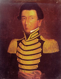
Juan Nepomuceno Seguín was a Spanish-Tejano political and military figure of the Texas Revolution who helped to establish the independence of Texas. Numerous places and institutions are named in his honor, including the county seat of Seguin in Guadalupe County, the Juan N. Seguin Memorial Interchange in Houston, Juan Seguin Monument in Seguin, World War II Liberty Ship SS Juan N. Seguin, Seguin High School in Arlington.
Galena Park Independent School District is a school district based in the Channelview CDP of unincorporated Harris County, Texas, United States.

The Old Spanish Trail was an auto trail that once spanned the United States with almost 2,750 miles (4,430 km) of roadway from ocean to ocean. It crossed eight states and 67 counties along the southern border of the United States. Work on the auto highway began in 1915 at a meeting held at the Battle House Hotel in Mobile, Alabama; and, by the 1920s, the trail linked St. Augustine, Florida, to San Diego, California, with its center and headquarters in San Antonio, Texas. The work at San Antonio, and indeed nationally, was overseen by an executive committee consisting of prominent San Antonio businessmen which met at the Gunter Hotel weekly.

Spanish Fort is an unincorporated community in north central Montague County, Texas, United States at the end of Farm Road 103 one mile south of the Red River.
Kohrville, also named Korville and Pilotville, is an unincorporated community in Harris County, Texas.

Carpenters Bayou rises at the south end of Sheldon Reservoir in southeastern Harris County, Texas, USA. The bayou waterway routes southeast for about twelve miles until it joins Buffalo Bayou at the San Jacinto Battleground State Historic Site.

The Lynchburg Ferry is a free ferry across the Houston Ship Channel in the U.S. state of Texas, connecting Crosby-Lynchburg Road in Lynchburg to the north with the former State Highway 134 and San Jacinto Battleground State Historic Site in La Porte to the south. Operated by the Harris County Toll Road Authority, the 1,080 feet (330 m) crossing is the oldest operating ferry service within the state of Texas.

Texas Gulf Coast is an intertidal zone which boundaries the coastal region of South Texas, Southeast Texas, and the Texas Coastal Bend. The Texas coastal geography boundaries the Gulf of Mexico encompassing a geographical distance relative bearing at 367 miles (591 km) of coastline according to CRS and 3,359 miles (5,406 km) of shoreline according to NOAA.

Manuel Flores served as a volunteer in the Texas army in 1835–1838. Fighting and commanding, he rose through the ranks to reach sergeant status during the fight for Texas independence and was commissioned a captain during the Republic years.

Montopolis is a neighborhood in Austin, Texas. Located southeast of the city's urban core, Montopolis encompasses part of ZIP code 78741.
Park Road 1836 (PR 1836), also known as San Jacinto Battleground State Park Road and Juan N. Seguin Boulevard, is a Park Road in southeast Texas. The route is 7.234 miles (11.642 km) long, and connects San Jacinto Battleground State Historic Site to Independence Parkway in Houston in southeast Harris County. The designation is given to multiple roads on the park grounds. The road was designated as PR 9 in 1939 before receiving its current designation in 1960.

The San Jacinto County Courthouse is a historic courthouse in the San Jacinto county seat of Coldspring, Texas. It was designated a Recorded Texas Historic Landmark in 2000 and listed on the National Register of Historic Places in 2003.


