Westchester County is located in the U.S. state of New York. It is the second-most populous county on the mainland of New York, after the Bronx, and the most populous county in the state north of New York City. According to the 2010 U.S. census, the county had a population of 949,113, estimated to have increased to 967,506 by 2019. Situated in the Hudson Valley, Westchester covers an area of 450 square miles (1,200 km2), consisting of six cities, 19 towns, and 23 villages. Established in 1683, Westchester was named after the city of Chester, England. The county seat is the city of White Plains, while the most populous municipality in the county is the city of Yonkers, with an estimated 199,663 residents in 2018.

Larchmont is a village located within the Town of Mamaroneck in Westchester County, New York, approximately 18 miles (29 km) northeast of Midtown Manhattan. The population of the village was 5,864 at the 2010 census. In February 2019, Bloomberg ranked Larchmont as the 15th wealthiest place in the United States, and the third wealthiest in New York.

New Rochelle is a city in Westchester County, New York, United States, in the southeastern portion of the state. In 2010, the city had a population of 77,062, making it the seventh-largest in the state of New York.
Southern Westchester refers to the southern portion of Westchester County, New York, a dense inner-ring suburban area north of New York City.
Harbor Heights is a residential section of the Village of Mamaroneck in Westchester County, New York. It is bordered by an arc of the Mamaroneck River on the north and east, by the Saxon Woods Park on the west and the New England Thruway on the south.
New York State Route 125 (NY 125) is a 7.50-mile (12.07 km) north–south state highway located within Westchester County, New York, in the United States. The route begins at an intersection with U.S. Route 1 (US 1) in the Town of Mamaroneck and ends at a junction with NY 22 in the city of White Plains. A section of the route in the city of White Plains is maintained by Westchester County and co-designated as County Route 26 (CR 26). A second county-owned segment exists along the New Rochelle–Scarsdale line as County Route 129. Both numbers are unsigned. NY 125 was assigned as part of the 1930 renumbering of state highways in New York, initially extending from US 1 to Mamaroneck Avenue in White Plains. It was extended north to NY 22 in the mid-1930s.

The New York, Westchester and Boston Railway Company, was an electric commuter railroad in the Bronx and Westchester County, New York from 1912 to 1937. It ran from the southernmost part of the South Bronx, near the Harlem River, to Mount Vernon with branches north to White Plains and east to Port Chester. From 1906, construction and operation was under the control of the New York, New Haven & Hartford Railroad (NH) until its bankruptcy in 1935.

Wykagyl is a suburban community in New Rochelle, Westchester County, New York. It is conterminous with ZIP code 10804, encompassing much of the city's 'North End'. According to Forbes, in 2010 Wykagyl's 10804 ZIP code, with a median home price of $806,264, ranked 333rd on its list of the 500 most expensive ZIP codes in the U.S. The Washington Post ranks Wykagyl among the nation's 650 Super Zips, or those with the highest percentile rankings for median household income and the share of adults with college degrees or higher.
Rochelle Heights is a historic residential neighborhood in the city of New Rochelle, in Westchester County, New York. The area is bordered by the City Park area on the east, Interstate 95 on the south, and Rochelle Park on the west. The Rochelle Heights and Rochelle Park neighborhoods together create the Rochelle Park-Rochelle Heights Historic District.

The Rochelle Park–Rochelle Heights Historic District is a historic residential district located in the city of New Rochelle in Westchester, New York. The district is historically and architecturally significant as an intact and distinctive example of residential park development at the turn of the Twentieth Century. It includes the historic Rochelle Park development, and the later Rochelle Heights subdivision. Within the district are 555 contributing properties, including 513 buildings, 38 structures, and 4 sites. Only 24 buildings and 1 site separately identified within its area are non-contributing. It was listed on the National Register of Historic Places (NRHP) on July 6, 2005.
New Rochelle is a city in Westchester County, New York, United States, in the southeastern portion of the state. The town was settled by refugee Huguenots in 1688 who were fleeing Catholic pogroms in France. Many of the settlers were artisans and craftsmen from the city of La Rochelle, France, thus influencing the choice of the name of "New Rochelle".

This is a list of the National Register of Historic Places listings in southern Westchester County, New York, excluding the cities of New Rochelle and Yonkers, which have separate lists of their own.
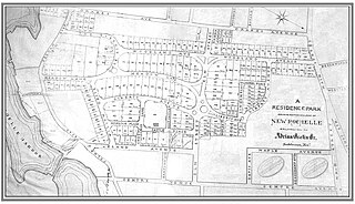
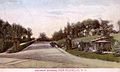
Residence Park is a historic community located in the city of New Rochelle, in Westchester County, New York. It is one of the first planned residential parks, and garden city communities, in the United States. It is located in the southern section of the city, bordered by Neptune Park on the west, Shore Road and Long Island Sound on the south, and Downtown New Rochelle on the north.
Sutton Manor is a distinctive early 20th century suburban residential district in the city of New Rochelle in Westchester County, New York. The neighborhood is located off the northern shore of Long Island Sound on Echo Bay. It was developed as an upper middle class enclave for families with heads of households employed in New York City and served as a model for the ideal suburban setting; harmonious architecture and exclusive amenities. The development appears to have been modeled on neighboring Larchmont Manor in the Town of Mamaroneck, yet on a smaller scale. That subdivision was conceived originally as an exclusive and convenient seasonal playground for New York’s wealthy upper classes, with its 6-acre waterfront park.

Quaker Ridge is a former railroad station on the White Plains branch of the New York, Westchester and Boston Railway in the city of New Rochelle in Westchester County, New York. The station is named for the Quaker Ridge section of northern New Rochelle along the Scarsdale Town border. It was constructed by the New York, Westchester & Boston commuter railroad which linked Manhattan with the less populous northern Bronx section of New York City and the primarily undeveloped countryside of Westchester County.
Winyah Park was the 300-acre country estate of Colonel Richard Lathers, located in the village of New Rochelle, Westchester County, New York, upon which a number of 19th-century Gothic villas and cottages designed by Alexander Jackson Davis were built. It was in 1848, after a brief but successful business career in New York, that, attracted by the accessibility and the natural environment of New Rochelle, Colonel Richard Lathers purchased a large country estate and farm along the New Rochelle and Pelham border. Three years later, in 1851, Lathers employed his personal friend and renowned architect Alexander Jackson Davis to design him a more seemly and dignified residence than the old farmhouse which existed. Revolutionizing the traditional single-house form that dominated colonial and early 19th-century domestic architecture, Davis was creating many of the country's finest villas and cottages in an entirely new, purely American style. The residence designed for Lathers was the landmark brick and marble Italian villa "Winyah", named for Lathers former estate in Winyah Parish, South Carolina.

Sheldrake Lake is a man-made body of water located in the north-eastern section of New Rochelle in Westchester County, New York. It has a surface area of 25 acres and formerly served as the water supply for neighboring Larchmont village. The lake is the result of Larchmont Water Company Dam #2 on the Sheldrake River. The dam, constructed in 1935, is masonry with a height of 31 feet (9.4 m) and a length of 1,000 feet (300 m). The dam has a maximum discharge is 987 cubic feet (27.9 m3) per second and drains an area of 2.66 square miles (6.9 km2).

Premium Mill-Pond is located in the communities of New Rochelle and Mamaroneck in Westchester County, New York. The mill-pond is situated northeast of Echo Bay, between the Premium Point peninsula and the mainland. It is fed by the Premium River and is separated from Echo Bay by a dam that creates a waterfall into the harbor.
The Premium River - Pine Brook Wetlands are located on Long Island Sound in the City of New Rochelle, Town of Mamaroneck, and the Village of Larchmont in Westchester County, New York. The fish and wildlife habitat is an approximately 65 acre area including Pine Brook south of the Boston Post Road, the Premium River, Premium Mill-Pond, the northeast portion of Echo Bay, and Pryer Manor Marsh.The land area bordering the wetlands complex is predominantly moderate density residential and commercial. The portion of the habitat area within Mamaroneck and Larchmont was designated as a 'Critical Environmental Area' under the State Environmental Quality Review Act.