Belews Lake

Last updated
Belews Lake
Belews Lake NC-kmf.JPG
USA North Carolina relief location map.jpg
Red pog.svg
Belews Lake
Usa edcp relief location map.png
Red pog.svg
Belews Lake
Location Stokes / Rockingham / Guilford / Forsyth counties, North Carolina, United States
Coordinates 36°17′56″N80°02′15″W / 36.2990°N 80.0375°W / 36.2990; -80.0375
Type reservoir
Primary inflows Belews Creek
Primary outflows Belews Creek
Basin  countriesUnited States
Max. length5.15 miles (8.29 km)
Max. width0.96 miles (1.54 km)
Surface area3,864-acre (16 km2)
Surface elevation722 feet (220 m) [1]
Islands numerous islets

Belews Lake is a reservoir in Stokes, Rockingham, Guilford and Forsyth counties of North Carolina, near the towns of Stokesdale and Pine Hall. It was created in 1973 by the Duke Energy corporation as a cooling basin for the corporation's Belews Creek Steam Station, a coal-burning power plant.

Contents

There are 4 public boat ramps on the lake, with 2 being commissioned by the North Carolina Wildlife Resorces Commission (NCWRC). Piney Bluff is located on the southern part of the lake, in Forsyth County, with entrance on NC Highway 65. Pine Hall Boat Launch is the closest to the plant, located in Stokes County, with the ramp being located on the west-northwest part of the lake, with entrance from Pine Hall Rd. Carolina Marina is located in the northern part of the lake, in Rockingham County, with a fee for use.

Humphreys Ridge has a boat ramp located on the eastern side of the lake, in Rockingham County. The power plant can be seen from the ramp. Cooling water was pumped back and forth between the plant and reservoir until 1986 when the corporation decided to use other methods to dispose of their coal ash waste. From 1974-1986, contaminants such as vanadium, nickel, cobalt, barium, arsenic, were introduced into the lake through the release of contaminated cooling water from the power plant back into the lake. [2] Many scientific studies were undertaken at Belews Lake and their findings, along with those conducted at the Kesterson Reservoir, are fundamental to today's understanding of the ecological risks associated with elevated selenium concentrations in aquatic systems.

Background

Belews Creek Steam Station Belews Creek Steam Station.jpg
Belews Creek Steam Station

The lake has a surface area of 3,864 acres (16 km2) and an 88-mile (142 km) shoreline. It is held back by a rolled earth dam and a concrete spillway. The northern portion of the lake commonly has depths of over 100 feet (30 m) and the lake reaches up to 130 feet (40 m) deep in the vicinity of the dam. There is no hydroelectric power generation at this dam, so the lake is not bound by many FERC regulations.

It was formed from Belews Creek, a small tributary of the Dan River. U.S. Route 158 and North Carolina Highway 65, as well as a number of secondary roads provide access to the lake. Boating and water skiing are common on the lake.

Two marinas on the lake include Humphrey's Ridge, which has a grill that serves food, and Carolina Marina, which has a grill, boat sales, and service facilities.

Contamination

Belews Lake was contaminated with selenium as a result of the repeated release of wastewater generated by the adjacent Duke Energy coal-fired power plant into the lake beginning in 1974. [3] Selenium, when ingested in high concentrations is toxic to animals. [4] Selenium bioaccumulates in both terrestrial and aquatic food chains and in animals found at high trophic levels. [5] Elevated levels of selenium cause reproductive and teratogenic defects in fish populations and also inhibit gill, liver, kidney, heart, and eye function. [4]

The number of species of fish in the main basin of Belews Lake fell from 24 to 6 between 1975 and 2002. [6] One explanation for the decrease in species diversity is the sharp decline in reproduction rates of piscivorous fish, such as largemouth bass and green sunfish, after 1975 following the introduction of selenium rich coal ash sluice into the lake. [6] Another study found that 19 of the 20 original species found in Belews Lake experienced reproductive failure and no offspring successfully survived due to selenium poisoning. [4] The species composition of the lake changed from a mix of fish species at several trophic levels to a near complete dominance by fish at lower trophic levels that consume plankton and were not greatly impacted by selenium bioaccumulation. [6] Mosquitofish were found to be tolerant of heightened selenium levels and were able to thrive as other fish species were extirpated. [4]

Hundreds of analyses were run at Belews Lake as part of an 1988 study measuring potentially hazardous substances in the lake such as metals, metalloids, and pesticides, in addition to other physiochemical properties, but none were found to be of a level of concern except for selenium. [7] This led the scientists to conclude that selenium was the direct cause of fish kills in the lake. [7] Selenium was found to be the only inorganic element of an elevated concentration among the 16 elements that were measured in a 1985 review. [7]

In 1986, the coal-fired power plant stopped releasing selenium rich wastewater into the lake and instead sent dry ash waste to a landfill for disposal. [4] In the following years, sport fish, like bluegill and largemouth bass, were stocked and were successfully re-established in the lake. [4] Selenium concentrations in the water were measured at less than 1 microgram per liter in 1996 compared to a high of 20 micrograms per liter during the period of selenium loading into the system. Additionally, selenium concentrations in fish tissues were found to be 85-95% lower in 1996 compared with the period of active wastewater loading into the lake. [4] Despite the decrease in selenium concentrations in the water and in fish tissue, reproductive impairment was still observed in fish ten years after the wastewater release was halted. [4] This was due to the tendency selenium has to accumulate in sediments and slowly release back into the food web. [4] The presence of high selenium concentrations in sediments at the bottom of the lake also poses risk for quick reintroduction into the lake's food web if there were a disturbance event like a storm that mobilized the sediments. [4] Other factors extending the time it took the lake to recover was how long it takes the lake to flush out contaminated water because of its long retention time and the low rates of new water inflow both of which helped selenium persist in the lake ecosystem. [4]

Other ecological concerns

In 2011, a species of bass called Alabama bass was illegally introduced to Belews Lake for sportfishing. [8] In 2017, a dramatic decrease in the Largemouth bass population in Belews Lake was observed while the number of invasive Alabama bass rose quickly. [8] There are concerns that smallmouth bass may also be extirpated from the lake because of interbreeding and competition with Alabama Bass. [8] To address this issue, North Carolina officials eliminated catch limits on the number and size of Alabama bass that can be caught from Belews Lake to help mitigate the ecological damage these invasive fish cause. [8] A study undertaken at Lake Norman, another reservoir in North Carolina created by Duke Energy, found the introduction of Alabama bass caused a significant shift in species composition and a decline in Largemouth bass population over ten years that never recovered. [9]

See also

Related Research Articles

<span class="mw-page-title-main">Spotted bass</span> Species of fish

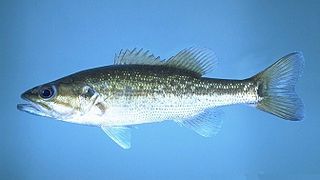
The spotted bass, also called spotty, or spots in various fishing communities, is a species of North American freshwater fish belonging to the sunfish family (Centrarchidae) of the order Perciformes. It is noted for the rows of dark spots below the lateral line, which give it its common name. One of the black basses, it is native to the Mississippi River basin and across the Gulf states, from central Texas through the Florida panhandle. Its native range extends into the western Mid-Atlantic states and it has been introduced into western North Carolina and Virginia. It has also been introduced to southern Africa, where it has become established in some isolated waters as an invasive species.

<span class="mw-page-title-main">Lake Marble Falls</span> Hydroelectric reservoir near Marble Falls, Texas

Lake Marble Falls is a reservoir on the Colorado River in the Texas Hill Country in the United States. The reservoir was formed in 1951 by the construction of Max Starcke Dam by the Lower Colorado River Authority. Originally named Marble Falls Dam, the dam was renamed in 1962 for Max Starcke, the second general director of the LCRA. Located near the city of Marble Falls, the lake is used as a venue for aquatic recreation and for the purpose of generating hydroelectric power. It is the newest and smallest of the Texas Highland Lakes.

<span class="mw-page-title-main">Cape Fear River</span> River in North Carolina, United States

The Cape Fear River is a 191.08-mile-long blackwater river in east-central North Carolina. It flows into the Atlantic Ocean near Cape Fear, from which it takes its name. The river is formed at the confluence of the Haw River and the Deep River in the town of Moncure, North Carolina. Its river basin is the largest in the state: 9,149 sq mi.

<span class="mw-page-title-main">Lake Koocanusa</span> Reservoir in Montana / British Columbia

Lake Koocanusa is a reservoir in British Columbia (Canada) and Montana formed by the damming of the Kootenai River by the Libby Dam in 1972. The Dam was formally dedicated by President Gerald Ford on August 24, 1975.

<span class="mw-page-title-main">Fly ash</span> Residue of coal combustion

Fly ash, flue ash, coal ash, or pulverised fuel ash – plurale tantum: coal combustion residuals (CCRs) – is a coal combustion product that is composed of the particulates that are driven out of coal-fired boilers together with the flue gases. Ash that falls to the bottom of the boiler's combustion chamber is called bottom ash. In modern coal-fired power plants, fly ash is generally captured by electrostatic precipitators or other particle filtration equipment before the flue gases reach the chimneys. Together with bottom ash removed from the bottom of the boiler, it is known as coal ash.

<span class="mw-page-title-main">Gibbons Creek Reservoir</span>

Gibbons Creek Reservoir is a power plant cooling reservoir on Gibbons Creek in the Navasota River basin, 20 miles (32 km) east of College Station, Texas, United States. The dam and lake are managed by Texas Municipal Power Agency (TMPA), which uses the reservoir as a cooling pond for a coal-fired power plant generating electricity for the cities of Bryan, Denton, Garland, and Greenville.

<span class="mw-page-title-main">Ecotoxicology</span>

Ecotoxicology is the study of the effects of toxic chemicals on biological organisms, especially at the population, community, ecosystem, and biosphere levels. Ecotoxicology is a multidisciplinary field, which integrates toxicology and ecology.

<span class="mw-page-title-main">Lake Lafayette</span> Lake in Leon County, Florida, US

Lake Lafayette is a prairie lake located in the coastal lowland in eastern Tallahassee, Leon County, Florida with US 27 / State Road 20 running close on its south side.

<span class="mw-page-title-main">Lake Walter E. Long</span> Lake of the United States

Lake Walter E. Long is a power plant cooling reservoir on Decker Creek in Austin, Texas. The reservoir was officially impounded in 1967 and serves to provide water for turbines used in the production of electricity from petroleum-based fuels. The dam and the lake are managed by the City of Austin. Surrounding Lake Walter E. Long is the city of Austin's Lake Walter E. Long Metropolitan Park, a popular recreational destination.

Meadow Lake is a reservoir on the Guadalupe River south of the town of Seguin in Guadalupe County, Texas. The reservoir was formed in 1931 by the construction of a dam to provide hydroelectric power to the area. Management of the dam and lake was assumed by the Guadalupe-Blanco River Authority on May 1, 1963. Meadow Lake also serves as a venue for outdoor recreation, including fishing and boating.

<span class="mw-page-title-main">Calaveras Lake (Texas)</span> Power plant cooling reservoir in near San Antonio, Texas

Calaveras Lake is a reservoir on Calaveras Creek, located 20 miles southeast of Downtown San Antonio, Texas, USA. The reservoir was formed in 1969 by the construction of a dam to provide a cooling pond for a series of power plants, called the Calaveras Power Station, to supply additional electricity to the city of San Antonio.

<span class="mw-page-title-main">Victor Braunig Lake</span> Power plant cooling reservoir in San Antonio, Texas

Victor Braunig Lake, formerly known as East Lake, is a reservoir on Calaveras Creek and Chupaderas Creek 17 miles south of Downtown San Antonio, Texas, USA. The reservoir was formed in 1962 by the construction of a dam to provide a cooling pond for a power plant to supply additional electrical supply to the city of San Antonio. Victor Braunig (1890-1982) was an employee from 1910 becoming in 1949 the general manager of the San Antonio City Public Service Board, the predecessor of CPS Energy. The dam and lake are managed by CPS Energy of San Antonio. Together with Calaveras Lake, Braunig Lake was one of the first projects in the nation to use treated wastewater for power plant cooling. The reservoir is partly filled with wastewater that has undergone both primary and secondary treatment at a San Antonio Water System treatment plant. Braunig Lake also serves as a venue for recreation, including fishing and boating.

The Kesterson Reservoir is part of the current San Luis National Wildlife Refuge in California. Formerly a unit of the Kesterson National Wildlife Refuge, the reservoir was an important stopping point for migratory waterfowl. Kesterson once consisted of 12 evaporation ponds totaling approximately 1,280 acres, and was historically used for agricultural drainage. Kesterson gained national attention during the latter half of the 20th century due to selenium toxicity and rapid die off of migratory waterfowl, fish, insects, plants and algae. The reservoir was closed in 1986, and concentrations of selenium at the site have continued to be monitored throughout remediation efforts.

Baldwin Lake is a 2,018-acre (817 ha) reservoir which spans part of the border between Randolph County, Illinois and St. Clair County, Illinois. The lake is part of the Kaskaskia River State Fish and Wildlife Area, near 38°13′03″N089°52′09″W Elevation: 430 feet (130 m), operated by the Illinois Department of Natural Resources, and it is adjacent to, but not part of, the Kaskaskia River. Its elevation may fluctuate with powerplant operations, but averages 423 feet (129 m) above sea level.

<span class="mw-page-title-main">Canton Lake (Illinois)</span> Reservoir in Fulton County

Canton Lake is a freshwater reservoir located in Fulton County, Illinois. It is located east of Canton on Illinois Route 27.

<span class="mw-page-title-main">Lake chubsucker</span> Species of fish

The lake chubsucker is a species of freshwater fish endemic to North America, found in the Great Lakes and the Mississippi River basin, as far north as Ontario, Canada, extending south to the Gulf of Mexico. It is mainly found in lakes, ponds, and swamps, rarely in streams.

<span class="mw-page-title-main">Turtle-Flambeau Flowage</span> Lake of the United States of America

The Turtle-Flambeau Flowage is a 12,942 acres (52.37 km2) lake in Iron County, Wisconsin. It has a maximum depth of 15 meters and is the seventh largest lake in the state of Wisconsin by surface area. The flowage is home to unique wetland patterns and plant species as well as several species of sport and game fish, including Musky, Panfish, Largemouth Bass, Smallmouth Bass, Northern Pike, Walleye and Sturgeon. The lake's water clarity is low, but can vary in different locations in the lake. Fishing, camping, boating, and hunting are popular activities on the flowage, and Ojibwe people traditionally harvest fish and game on the lake. Environmental concerns on the flowage include mercury contamination, algal blooms, and several types of invasive species.

<span class="mw-page-title-main">2014 Dan River coal ash spill</span> Ecological disaster in North Carolina

In February 2014, an Eden, North Carolina facility owned by Duke Energy spilled 39,000 tons of coal ash into the Dan River. The company later pled guilty to criminal negligence in their handling of coal ash at Eden and elsewhere and paid fines of over $5 million. The U.S. Environmental Protection Agency (EPA) has since been responsible for overseeing cleanup of the waste. EPA and Duke Energy signed an administrative order for the site cleanup.

Lake Athens is a 1,799 acre reservoir located to the east of Athens, Texas in Henderson County.

<span class="mw-page-title-main">Powerton Lake State Fish and Wildlife Area</span> State park in Illinois, USA

Powerton Lake State Fish and Wildlife Area is a 1,426-acre (577 ha) area of semi-protected habitat on the Illinois River southwest of to the city of Pekin, Illinois within Tazewell County in the U.S. state of Illinois. The parcel is a cooling reservoir owned by NRG Energy, an electric power generating firm, and is operated by the Illinois Department of Natural Resources (IDNR). The lake is used for fishing, with an emphasis on blue catfish. In addition, IDNR states that approximately 60% of the cooling pond is used for duck and goose hunting during legal hunting seasons. The remaining 40% of the pond is maintained as a waterfowl refuge on a year-round basis.

References

  1. get-direction.com website, at http://www.get-direction.com/altitude.html .
  2. "Protecting Our Water from Power Plant Pollution" (PDF).
  3. Lemly, A. Dennis (August 28, 1996). "Ecosystem Recovery Following Selenium Contamination in a Freshwater Reservoir". Ecotoxicology and Environmental Safety. 36 (3): 275–81. CiteSeerX   10.1.1.436.6155 . doi:10.1006/eesa.1996.1515. PMID   9143456.
  4. 1 2 3 4 5 6 7 8 9 10 11 Lemly, A. Dennis (2002-04-01). "Symptoms and implications of selenium toxicity in fish: the Belews Lake case example". Aquatic Toxicology. State of Science and Future Needs for Selenium Aquatic Criteria. 57 (1): 39–49. doi:10.1016/S0166-445X(01)00264-8. ISSN   0166-445X. PMID   11879937.
  5. Hoffman, David J.; Rattner, Barnett A.; Burton, G. Allen Jr.; Cairns, John Jr. (2002-11-13). Handbook of Ecotoxicology. CRC Press. ISBN   978-1-4200-3250-5.
  6. 1 2 3 Browne, Robert A.; Lutz, David (2010-11-01). "Lake ecosystem effects associated with top-predator removal due to selenium toxicity". Hydrobiologia. 655 (1): 137–148. doi:10.1007/s10750-010-0416-3. ISSN   1573-5117. S2CID   20167276.
  7. 1 2 3 Hamilton, Steven J. (2004-06-29). "Review of selenium toxicity in the aquatic food chain". Science of the Total Environment. 326 (1): 1–31. Bibcode:2004ScTEn.326....1H. doi:10.1016/j.scitotenv.2004.01.019. ISSN   0048-9697. PMID   15142762.
  8. 1 2 3 4 Caranna, Kenwyn. "Invasive bass species poses threat to native largemouth and smallmouth bass in Belews Lake". Greensboro News and Record. Retrieved 2020-11-18.
  9. Dorsey, Lawrence (2016). "Changes in Black Bass Population Characteristics after the Introduction of Alabama Bass in Lake Norman, North Carolina". Journal of the Southeastern Association of Fish and Wildlife Agencies. 3: 161–166.