
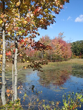
Hamlin Beach State Park is a 1,287-acre (5.21 km2) state park located on the shore of Lake Ontario in the Town of Hamlin in Monroe County, New York, United States. The Lake Ontario State Parkway passes through the park.
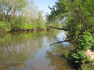
Verona Beach State Park is a 1,735-acre (7.02 km2) state park located on the eastern shore of Oneida Lake in the Town of Verona, Oneida County, New York. The park is located on NY 13 northwest of the City of Oneida and south of Sylvan Beach. Oneida Creek enters the Oneida Lake south of the park.

The Kal-Haven Trail, formally known as the Kal-Haven Trail Sesquicentennial State Park, is a rail trail in the US that originally ran 33.5 miles (53.9 km) between South Haven, Michigan, to a point just west of the city of Kalamazoo, Michigan, where there is a trailhead. In 2008, the trail was extended east from the trailhead to downtown Kalamazoo as part of the Kalamazoo River Valley Trail.

Lake Cushman is a 4,014.6-acre (16.247 km2) lake and reservoir on the north fork of the Skokomish River in Mason County, Washington. The lake originally was a long narrow broadening of the Skokomish River formed in a glacial trough and dammed by a terminal moraine from the Vashon Glaciation during the most recent ice age.

The Upper Las Virgenes Canyon Open Space Preserve is a large open space nature preserve owned and operated by the Santa Monica Mountains Conservancy spanning nearly 3,000 acres (1,200 ha) in the Simi Hills of western Los Angeles County and eastern Ventura County.

Runyon Canyon Park is a 160-acre (65 ha) park in Los Angeles, California, at the eastern end of the Santa Monica Mountains, managed by the Los Angeles Department of Recreation and Parks. The southern entrance to the park is located at the north end of Fuller Avenue in Hollywood. The northern entrance is off the 7300 block of Mulholland Drive. The Runyon Canyon Road, a fire road that is closed to public motor vehicle access, runs roughly through the center of the park between the northern and southern entrances along Runyon Canyon itself, and there are numerous smaller hiking trails throughout the park. The highest point in the park at an elevation of 1,320 ft is known as Indian Rock. Because of its proximity to residential areas of Hollywood and the Hollywood Hills, celebrity sightings are common. The park is also noted for having a fairly liberal dog policy, with dogs allowed off-leash in 90 of the park's 160 acres (0.65 km2). The park is part of the Santa Monica Mountains National Recreation Area.

Prince Gallitzin State Park is a 6,249-acre (2,529 ha) Pennsylvania state park with acreage in both Chest and White Townships in Cambria County of West Central Pennsylvania in the United States, near both Gallitzin Borough, & Gallitzin Township in the greater Altoona, Pennsylvania area.

The Cape Cod Rail Trail (CCRT) is a 25.5-mile (41.0 km) paved rail trail located on Cape Cod in Massachusetts. The trail route passes through the towns of Yarmouth, Dennis, Harwich, Brewster, Orleans, Eastham, and Wellfleet. It connects to the 6-plus mile (10 km) Old Colony Rail Trail leading to Chatham, the 2 mile Yarmouth multi-use trail, and 8 miles (13 km) of trails within Nickerson State Park. Short side trips on roads lead to national seashore beaches including Coast Guard Beach at the end of the Nauset Bike Trail in Cape Cod National Seashore. The trail is part of the Claire Saltonstall Bikeway.

The Palouse to Cascades State Park Trail, formerly known as the John Wayne Pioneer Trail and the Iron Horse Trail, is a rail trail that spans most of the U.S. state of Washington. It follows the former railway roadbed of the Chicago, Milwaukee, St. Paul & Pacific Railroad for 300 miles (480 km) across two-thirds of the state, from the western slopes of the Cascade Mountains to the Idaho border.

The Snohomish County Centennial Trail is a 30-mile-long (48 km) rail trail in Snohomish County, Washington, connecting the cities of Snohomish, Lake Stevens, and Arlington to Skagit County along the corridor of Washington State Route 9. The trail, administered by Snohomish County Parks and Recreation, is on the former right-of-way of the Seattle, Lake Shore and Eastern Railway and comprises a 10-foot-wide (3.0 m) non-motorized trail and a 6-foot-wide (1.8 m) equestrian trail. The first segment of the corridor was opened in 1989, the centennial of the statehood of Washington, and the final segment between Arlington and the Skagit County line was opened in 2013.
Mayo River State Park is a North Carolina state park in Rockingham County, North Carolina in the United States. It covers 2,778-acre (11.24 km2) along the Mayo River, and it adjoins a Virginia State Park of the same name. North Carolina's park is near Mayodan, North Carolina. The park is one of the newest in the North Carolina system, having been authorized by the General Assembly in May 2003.

Lost Dutchman State Park is a 320-acre (129 ha) state park located in northwestern Pinal County, Arizona on the Apache Trail north of Apache Junction, near the Superstition Mountains in central Arizona. It is named after the Lost Dutchman's Gold Mine, a famously lost gold mine legendary in the tales of the Old West. It is accessible about 40 miles (64 km) east of Phoenix via U.S. Highway 60, the Superstition Freeway.

Orchard Park is a municipal park in Hillsboro in the U.S. state of Oregon. Opened in 2003, the park covers 21 acres (8.5 ha) along Rock Creek in the Tanasbourne neighborhood. The park includes nature trails, a playground, and a nine-hole disc golf course. Employees of the R.E.I. store at the nearby The Streets of Tanasbourne adopted the park in the city’s 'Adopt a Park' program.
Cumberland Valley Rail Trail (CVRT) is a National Recreation Trail rail trail that follows the former Cumberland Valley Railroad corridor for 9.5 miles in Cumberland County, Pennsylvania. CVRT travels through the farmlands from Shippensburg to Newville.

The Lebanon Valley Rail Trail (LVRT) is a National Recreation Trail. The rail trail goes from the southwestern border of Lebanon County and goes through Colebrook, Mt. Gretna, Cornwall, and the city of Lebanon. At the southern border of Lebanon County, Pennsylvania the LVRT connects with the Conewago Recreation Trail and continues for another 5.0 miles (8.0 km). The trail is partly built on the old Cornwall–Lebanon Railroad created by industrialist Robert H. Coleman in the 1880s. The trail runs 15.0 miles (24.1 km), and there are many phases in development that would extend the trail to northern Lebanon County and Jonestown. The trail features a packed stone path and paved path at many parts that traverses "Pennsylvania Dutch Country" and other scenic routes. Trail users see untouched woodlands of state gamelands, forests, and views of area fields and farms. The trail is maintained by dedicated group of volunteers, and allows for running, walking, biking, horseback riding, and cross-country skiing.

The John Yarbrough Linear Park is a 6-mile linear park trail located in Fort Myers, Florida. The trail parallels the Ten Mile Canal and the Seminole Gulf Railway, and is owned and operated by Lee County Parks and Recreation. It is part of Lee County's Tour de Parks route along with Lakes Regional Park and other locations.
The West Side Trail is a multi-use trail in Yarmouth, Maine. A Town of Yarmouth project conceived in 1988 and opened in 2014, the trailhead for the eastern portion of the trail is in the parking lot of Tyler Technologies, on Tyler Drive, on the eastern side of U.S. Route 1, immediately before the exit 15 northbound on-ramp to Interstate 295 (I-295). The trailhead for the western section is in the park and ride lot at the southbound exit 15 ramp for I-295, to the west of Route 1.

Stan Hedwall Park is the largest park in Chehalis, Washington at 204-acres. It is located west of I-5, and southeast of Lintott-Alexander Park and the beginning trailhead for the Willapa Hills Trail.

The Willapa Hills Trail is a 56.0-mile (90.1 km) intercounty rail trail in the U.S. state of Washington that is part of the Willapa Hills State Park. Following an east–west route alongside State Route 6, the tract links Chehalis and South Bend, traveling through or near several small towns and parks along the way. Overseen by the Washington State Parks and Recreation Commission, local cities and towns often maintain areas of the trail within their jurisdictions. The trail is built upon a decommissioned railroad track.

Mayo River State Park is a state park of Virginia located in Henry County, along the North and South Forks of the Mayo River. The entrance to the park is located in Spencer. The park is located along the Virginia-North Carolina state line, and it is adjacent to a similarly named park in North Carolina.