Related Research Articles

Lane County is one of the 36 counties in the U.S. state of Oregon. As of the 2020 census, the population was 382,971, making it the fourth-most populous county in Oregon. The county seat is Eugene, the state's second most populous city. It is named in honor of Joseph Lane, Oregon's first territorial governor.

Cottage Grove is a city in Lane County, Oregon, United States. Its population was 10,643 at the 2020 census. It is the third largest city in Lane County. It is on Interstate 5, Oregon Route 99, and the main Willamette Valley line of the CORP railroad.

Butte is a consolidated city-county and the county seat of Silver Bow County, Montana, United States. In 1977, the city and county governments consolidated to form the sole entity of Butte-Silver Bow. The city covers 718 square miles (1,860 km2), and, according to the 2020 census, has a population of 34,494, making it Montana's fifth-largest city. It is served by Bert Mooney Airport with airport code BTM.

The Clark Fork, or the Clark Fork of the Columbia River, is a river in the U.S. states of Montana and Idaho, approximately 310 miles (500 km) long. The largest river by volume in Montana, it drains an extensive region of the Rocky Mountains in western Montana and northern Idaho in the watershed of the Columbia River. The river flows northwest through a long valley at the base of the Cabinet Mountains and empties into Lake Pend Oreille in the Idaho Panhandle. The Pend Oreille River in Idaho, Washington, and British Columbia, Canada which drains the lake to the Columbia in Washington, is sometimes included as part of the Clark Fork, giving it a total length of 479 miles (771 km), with a drainage area of 25,820 square miles (66,900 km2). In its upper 20 miles (32 km) in Montana near Butte, it is known as Silver Bow Creek. Interstate 90 follows much of the upper course of the river from Butte to Saint Regis. The highest point within the river's watershed is Mount Evans at 10,641 feet (3,243 m) in Deer Lodge County, Montana along the Continental Divide.
The Big River is a tributary of the Coast Fork Willamette River, approximately 12 miles (19 km) long, in western Oregon in the United States. It drains an area of the Calapooya Mountains south of Eugene.

New Idria was an unincorporated town in San Benito County, California. It was named after the New Idria Mercury Mine, which closed in 1972, resulting in a ghost town.

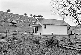
Dorena is an unincorporated community in Lane County, Oregon, United States. It is located southeast of Cottage Grove on the Row River, a tributary of the Coast Fork Willamette River.

Walden is an unincorporated community in Lane County, Oregon, United States. It is about 3 miles (5 km) southeast of Cottage Grove, near the confluence of the Row River and Mosby Creek.

Cottage Grove Community Hospital was founded by PeaceHealth after the existing community hospital declared bankruptcy. It is located in Cottage Grove, Oregon, in southern Lane County. The facility provides 24-hour emergency care and a 14-bed inpatient unit.

The Chambers Covered Bridge is a covered bridge located in Cottage Grove, Oregon, United States. It is 78 feet (24 m) long and spans the Coast Fork Willamette River. It was built in 1925 to carry rail traffic hauling logs from the Lorane Valley to the J.H. Chambers Mill, a lumber mill which was located on an area between South Highway 99 and the Coast Fork Willamette River. The mill closed in the 1950s after a second fire burned the mill down. The railroad tracks were removed and the bridge was left. The mill property is now being developed as a housing development called Riverwalk. The Chambers Covered Railroad Bridge is the only remaining fully covered railroad bridge west of the Mississippi River.
London Springs is an unincorporated community in Lane County, Oregon, United States. It lies 11.33 miles (18.23 km) south-southwest of Cottage Grove at an elevation of 896 feet (273 m). London Springs is near the Coast Fork Willamette River, south of Cottage Grove Lake.
Disston is an unincorporated community in Lane County, Oregon, United States, southeast of Cottage Grove where Brice Creek and Layng Creek join to form the Row River. It is about a mile west of the Umpqua National Forest. Its post office opened in 1906 and ran until 1974. Cranston Jones—the first postmaster—was also one of the founders of the first sawmill in Disston and the name of the town came from the famous Disston saws.

The Trout Creek Mountains are a remote, semi-arid Great Basin mountain range mostly in southeastern Oregon and partially in northern Nevada in the United States. The range's highest point is Orevada View Benchmark, 8,506 feet (2,593 m) above sea level, in Nevada. Disaster Peak, elevation 7,781 feet (2,372 m), is another prominent summit in the Nevada portion of the mountains.
Culp Creek is an unincorporated community in Lane County, Oregon, United States, southeast of Cottage Grove on the Row River. It lies on Row River Road between Dorena and Disston.
Latham is an unincorporated community in Lane County, Oregon, United States. It is located on Interstate 5 about 2 miles south of downtown Cottage Grove. The community was named after the politician Milton S. Latham. The post office operated for about ten years, from September 16, 1878 to February 14, 1888. James J. Comstock was its first postmaster. Latham is now served by the Cottage Grove post office.
Nonpareil is an unincorporated historic community in Douglas County, Oregon, United States. It is about 8 miles (13 km) east of Sutherlin, near Calapooya Creek. The population of the area was about 202 in 2000. Nonpareil was the birthplace of novelist H. L. Davis.
Walker is an unincorporated community in Lane County, Oregon, United States. It is located about 4 miles (6 km) north of Cottage Grove on Oregon Route 99, near the Coast Fork Willamette River.
The Little River is a tributary of the Coast Fork Willamette River in the U.S. state of Oregon. Rising along the Calapooya Divide near the border between Lane and Douglas counties, it flows generally west-northwest to meet the Big River. The combined Big and Little rivers form the Coast Fork near Black Butte. The butte is a dark-colored mountain, the site of a former mine, and the site of a former post office.
Garoutte Creek is a tributary of the Little River in the U.S. state of Oregon. Rising along the Calapooya Divide near the border between Lane and Douglas counties, it flows generally northeast to meet the larger stream near Black Butte. The butte is a dark-colored mountain, the site of a former mine, and the site of a former post office. Little River joins Big River a few miles downstream to form the Coast Fork Willamette River.
Hadleyville is an unincorporated community in Lane County, Oregon, United States. It is located about two miles southeast of Crow along Territorial Highway, near Coyote Creek.
References
- ↑ "Black Butte". Geographic Names Information System . United States Geological Survey, United States Department of the Interior. April 1, 1993. Retrieved December 28, 2015.
- ↑ Oregon Atlas & Gazetteer (7th ed.). Yarmouth, Maine: DeLorme. 2008. p. 47. ISBN 978-0-89933-347-2.
- 1 2 3 4 McArthur, Lewis A.; McArthur, Lewis L. (2003) [1928]. Oregon Geographic Names (7th ed.). Portland, Oregon: Oregon Historical Society Press. pp. 86, 393. ISBN 978-0875952772.
- ↑ "Black Butte Mine". U.S. Environmental Protection Agency . Retrieved December 28, 2015.
- 1 2 "Environmental Health Assessment: Black Butte Mine - Lane County". Oregon Health Authority . Retrieved December 28, 2015.
- ↑ "Blackbutte Post Office (historical)". Geographic Names Information System . United States Geological Survey, United States Department of the Interior. August 1, 1994. Retrieved December 28, 2015.
- ↑ "2 Grade Schools Approve Merger". The Register-Guard . January 15, 1932. Retrieved December 28, 2015.
