
South Dakota is a U.S. state in the North Central region of the United States. It is also part of the Great Plains. South Dakota is named after the Dakota Sioux Native American tribe, which comprises a large portion of the population with nine reservations currently in the state and have historically dominated the territory. South Dakota is the seventeenth largest by area, but the 5th least populous, and the 5th least densely populated of the 50 United States. As the southern part of the former Dakota Territory, South Dakota became a state on November 2, 1889, simultaneously with North Dakota. They are the 39th and 40th states admitted to the union; President Benjamin Harrison shuffled the statehood papers before signing them so that no one could tell which became a state first. Pierre is the state capital, and Sioux Falls, with a population of about 192,200, is South Dakota's largest city.

The Lakota are a Native American people. Also known as the Teton Sioux, they are one of the three prominent subcultures of the Sioux people, with the Eastern Dakota (Santee) and Western Dakota (Wičhíyena). Their current lands are in North and South Dakota. They speak Lakȟótiyapi—the Lakota language, the westernmost of three closely related languages that belong to the Siouan language family.
The Sioux or Oceti Sakowin are groups of Native American tribes and First Nations peoples in North America. The modern Sioux consist of two major divisions based on language divisions: the Dakota and Lakota; collectively they are known as the Očhéthi Šakówiŋ. The term "Sioux" is an exonym created from a French transcription ("Nadouessioux") of the Ojibwe term "Nadowessi", and can refer to any ethnic group within the Great Sioux Nation or to any of the nation's many language dialects.
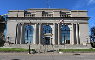
Pennington County is a county in the U.S. state of South Dakota. As of the 2020 census, the population was 109,222, making it the second-most populous county in South Dakota. Its county seat is Rapid City. The county was created in 1875, and was organized in 1877. It is named for John L. Pennington, fifth Governor of Dakota Territory, who held office in 1875 when the county was formed.

Scouting in South Dakota has a long history, from the 1910s to the present, and serves thousands of youth in programs that suit the environment in which they live.

Spearfish is a city in Lawrence County, South Dakota. The population was 12,193 at the time of the 2020 census, making it the 10th most populous city in South Dakota.
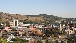
Rapid City is the second most populous city in South Dakota after Sioux Falls and the county seat of Pennington County. Named after Rapid Creek, where the settlement developed, it is in western South Dakota, on the Black Hills' eastern slope. The population was 74,703 as of the 2020 Census.

The Mount Rushmore National Memorial is a national memorial centered on a colossal sculpture carved into the granite face of Mount Rushmore in the Black Hills near Keystone, South Dakota, United States. Sculptor Gutzon Borglum designed the sculpture, called Shrine of Democracy, and oversaw the project's execution from 1927 to 1941 with the help of his son, Lincoln Borglum. The sculpture features the 60-foot-tall (18 m) heads of four United States presidents: George Washington (1732–1799), Thomas Jefferson (1743–1826), Theodore Roosevelt (1858–1919) and Abraham Lincoln (1809–1865). Mount Rushmore attracts more than two million visitors annually. The four presidents were chosen to represent the nation's birth, growth, development and preservation, respectively. The memorial park covers 1,278 acres and the mountain's elevation is 5,725 feet (1,745 m) above sea level.
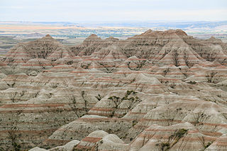
Badlands National Park is an American national park located in southwestern South Dakota. The park protects 242,756 acres of sharply eroded buttes and pinnacles, along with the largest undisturbed mixed grass prairie in the United States. The National Park Service manages the park, with the South Unit being co-managed with the Oglala Lakota tribe.

The black-footed ferret, also known as the American polecat or prairie dog hunter, is a species of mustelid native to central North America.

The Dakotas is a collective term for the U.S. states of North Dakota and South Dakota. It has been used historically to describe the Dakota Territory, and is still used for the collective heritage, culture, geography, fauna, sociology, economy, and cuisine of the two states.

Black Elk Peak is the highest natural point in the U.S. state of South Dakota and the Midwestern United States. It lies in the Black Elk Wilderness area, in southern Pennington County, in the Black Hills National Forest. The peak lies 3.7 mi (6.0 km) west-southwest of Mount Rushmore. At 7,244 feet (2,208 m), it is the highest summit in the United States east of the Rocky Mountains. Though part of the North American Cordillera, it is generally considered to be geologically separate from the Rocky Mountains.

Black Hills National Forest is located in southwestern South Dakota and northeastern Wyoming, United States. The forest has an area of over 1.25 million acres (5,066 km2) and is managed by the Forest Service. Forest headquarters are located in Custer, South Dakota. There are local ranger district offices in Custer, Rapid City, and Spearfish in South Dakota, and in Sundance, Wyoming.
"Hail! South Dakota!" is the regional anthem of South Dakota, selected by popular vote as the official state song. It was written and composed by DeeCort Hammitt (1893-1970).

South Dakota is a state located in the north-central United States. It is usually considered to be in the Midwestern region of the country. The state can generally be divided into three geographic regions: eastern South Dakota, western South Dakota, and the Black Hills. Eastern South Dakota is lower in elevation and higher in precipitation than the western part of the state, and the Black Hills are a low, isolated mountain group in the southwestern corner of the state. Smaller sub-regions in the state include the Coteau des Prairies, Missouri Coteau, James River Valley, and the Dissected Till Plains. Geologic formations in South Dakota range in age from two billion-year-old Precambrian granite in the Black Hills to glacial till deposited over the last few million years. South Dakota is the 17th-largest state in the country.

The Crazy Horse Memorial is a mountain monument under construction on privately held land in the Black Hills, in Custer County, South Dakota, United States. It will depict the Oglala Lakota warrior Crazy Horse, riding a horse and pointing to his tribal land. The memorial was commissioned by Henry Standing Bear, a Lakota elder, to be sculpted by Korczak Ziolkowski. It is operated by the Crazy Horse Memorial Foundation, a nonprofit organization.

The horned clubtail is a clubtail dragonfly of Canada and the United States.

Chase Iron Eyes is a Native American activist, attorney, politician, and a member of the Oglala Sioux Tribe. He is a member of the Lakota People's Law Project and a co-founder of the Native American news website Last Real Indians. In April 2016 he announced his candidacy for the United States House of Representatives for North Dakota's at-large congressional district. He lost to incumbent Kevin Cramer.

Tokata Iron Eyes is a Native American activist and member of the Standing Rock Sioux tribe. Iron Eyes was a youth leader of "ReZpect our Water", a campaign against the proposed route of the Dakota Access Pipeline, and served on the board of a sustainable energy group called Indigenized Energy. Iron Eyes is also a singer and songwriter.


