
South Dakota is a U.S. state in the Midwestern region of the United States. It is named after the Lakota and Dakota Sioux Native American tribes, who compose a large portion of the population and historically dominated the territory. South Dakota is the seventeenth largest by area, but the fifth smallest by population and the 5th least densely populated of the 50 United States. As the southern part of the former Dakota Territory, South Dakota became a state on November 2, 1889, simultaneously with North Dakota. Pierre is the state capital and Sioux Falls, with a population of about 187,200, is South Dakota's largest city.

The Sioux are groups of Native American tribes and First Nations peoples in North America. The term is an exonym created from a French transcription of the Anishinaabe term "Nadouessioux", and can refer to any ethnic group within the Great Sioux Nation or to any of the nation's many language dialects. The modern Sioux consist of two major divisions based on language divisions: the Dakota and Lakota.
Meade County is a county in the U.S. state of South Dakota. As of the 2010 United States Census, the population was 25,434. Its county seat is Sturgis. The county was created in 1889 and was named for Fort Meade, which was garrisoned as a United States military post in the area in 1878 and was named for General George Meade.

Scouting in South Dakota has a long history, from the 1910s to the present, and serves thousands of youth in programs that suit the environment in which they live.

Bear Mountain is a mountain located in western Pennington County, South Dakota. It is the 3rd highest point in the Black Hills. There is a fire lookout tower on the summit.

Bear Butte is a geological laccolith feature located near Sturgis, South Dakota, United States, that was established as a State Park in 1961. An important landmark and religious site for the Plains Indians tribes long before Europeans reached South Dakota, Bear Butte is called Matȟó Pahá, or Bear Mountain, by the Lakota, or Sioux. To the Cheyenne, it is known as Noahȧ-vose or Náhkȯhe-vose, and is the place where Ma'heo'o (God) imparted to Sweet Medicine, a Cheyenne prophet, the knowledge from which the Cheyenne derive their religious, political, social, and economic customs.
Sioux is a Siouan language spoken by over 30,000 Sioux in the United States and Canada, making it the fifth most spoken indigenous language in the United States or Canada, behind Navajo, Cree, Inuit languages and Ojibwe.

Custer National Forest is located primarily in the south central part of the U.S. state of Montana but also has separate sections in northwestern South Dakota. With a total area of 1,188,130 acres (4,808 km2), the forest comprises over 10 separate sections. While in the westernmost sections, Custer National Forest is a part of the Greater Yellowstone Ecosystem, the easternmost sections are a combination of forest "islands" and grasslands. A portion of the forest is also part of the Absaroka-Beartooth Wilderness and constitutes over a third of the wilderness land. South of Red Lodge, Montana, the Beartooth Highway passes through the forest en route to Yellowstone National Park.

The Rosebud Indian Reservation (RIR) is an Indian reservation in South Dakota, United States. It is the home of the federally recognized Sicangu Oyate – also known as Sicangu Lakota, and the Rosebud Sioux Tribe (RST), a branch of the Lakota people. The Lakota name Sicangu Oyate translates into English as "Burnt Thigh Nation"; the French term "Brulé Sioux" is also used.

The Fort Berthold Indian Reservation is a U.S. Indian reservation in western North Dakota that is home for the federally recognized Mandan, Hidatsa, and Arikara Nation, also known as the Three Affiliated Tribes. The reservation includes lands on both sides of the Missouri River.

Black Hills National Forest is located in southwestern South Dakota and northeastern Wyoming, United States. The forest has an area of over 1.25 million acres (5,066 km²) and is managed by the Forest Service. Forest headquarters are located in Custer, South Dakota. There are local ranger district offices in Custer, Rapid City, and Spearfish in South Dakota, and in Sundance, Wyoming.

The Missouri National Recreational River is a National Recreational River located on the border between Nebraska and South Dakota. The designation was first applied in 1978 to a 59-mile section of the Missouri River between Gavins Point Dam and Ponca State Park. In 1991, an additional 39-mile section between Fort Randall Dam and Niobrara, Nebraska, was added to the designation. These two stretches of the Missouri River are the only parts of the river between Montana and the mouth of the Missouri that remain undammed or unchannelized. The last 20 miles of the Niobrara River and 6 miles of Verdigre Creek were also added in 1991.

South Dakota is a state located in the north-central United States. It is usually considered to be in the Midwestern region of the country. The state can generally be divided into three geographic regions: eastern South Dakota, western South Dakota, and the Black Hills. Eastern South Dakota is lower in elevation and higher in precipitation than the western part of the state, and the Black Hills are a low, isolated mountain group in the southwestern corner of the state. Smaller sub-regions in the state include the Coteau des Prairies, Coteau du Missouri, James River Valley, the Dissected Till Plains. Geologic formations in South Dakota range in age from two billion-year-old Precambrian granite in the Black Hills to glacial till deposited over the last few million years. South Dakota is the 17th-largest state in the country.
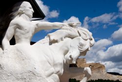
The Crazy Horse Memorial is a mountain monument under construction on privately held land in the Black Hills, in Custer County, South Dakota, United States. It will depict the Oglala Lakota warrior, Crazy Horse, riding a horse and pointing into the distance. The memorial was commissioned by Henry Standing Bear, a Lakota elder, to be sculpted by Korczak Ziolkowski. It is operated by the Crazy Horse Memorial Foundation, a nonprofit organization.
The Mammoth Site of Hot Springs, South Dakota is a museum and paleontological site near Hot Springs, South Dakota. It is an active paleontological excavation site at which research and excavations are continuing. The area of Mammoth Site of Hot Springs enclose a prehistoric sinkhole that formed and was slowly filled with sediments during the Pleistocene era. The sedimentary fill of the sinkhole contains the remains of Pleistocene fauna and flora preserved by entrapment and burial within a sinkhole. This site has the greatest concentration of mammoth remains in the world. As of 2016, the remains of 61 mammoths, including 58 North American Columbian and 3 woolly mammoths had been recovered. Mammoth bones were found at the site in 1974, and a museum and building enclosing the site were established. The museum now contains an extensive collection of mammoth remains.

Carlile Junction is the populated place in Wyoming where Wyoming Highway 24 has a terminus at US Route 14.

Whitecap Dakota First Nation is a Dakota First Nations band government whose reserve is located 26 km (16 mi) south of Saskatoon, Saskatchewan, Canada. Governing the Whitecap Indian Reserve No. 94, historically referred to as the Moose Woods Sioux Reserve, it is bordered by the Rural Municipality of Dundurn No. 314 and located along Highway 219 between the South Saskatchewan River and CFAD Dundurn.


