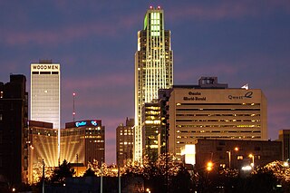
Omaha is the largest city in the U.S. state of Nebraska and the county seat of Douglas County. Omaha is in the Midwestern United States on the Missouri River, about 10 mi (15 km) north of the mouth of the Platte River. The nation's 40th-most populous city, Omaha's 2020 census population was 486,051.

Council Bluffs is a city in and the county seat of Pottawattamie County, Iowa, United States. It is the most populous city in Southwest Iowa, as well as the third largest and a primary city of the Omaha-Council Bluffs Metropolitan Area. It is located on the east bank of the Missouri River, across from Omaha, Nebraska. Until about 1853 Council Bluffs was known as Kanesville. Kanesville was the historic starting point of the Mormon Trail. Kanesville is also the northernmost anchor town of the other emigrant trails because there was a steam-powered boat which ferried the settlers' wagons and cattle across the Missouri River. In 1869, the first transcontinental railroad to California was connected to the existing U.S. rail network at Council Bluffs.
Thurston County is a county in the U.S. state of Nebraska. As of the 2020 United States Census, the population was 6,773. Its county seat is Pender.

Cass County is a county in the U.S. state of Nebraska. As of the 2020 United States Census, the population was 26,598. Its county seat and largest city is Plattsmouth. The county was formed in 1855, and was named for General Lewis Cass.

Carter Lake is a city in Pottawattamie County, Iowa, United States. A suburb of Omaha, Nebraska, it sits surrounding the south and west sides of the region's major airport, Eppley Airfield. It is separated from the rest of Iowa by the Missouri River, effectively making it an exclave. The population was 3,791 at the 2020 census.

The Iowa, also known as Ioway, and the Bah-Kho-Je or Báxoje are a Native American Siouan people. Today, they are enrolled in either of two federally recognized tribes, the Iowa Tribe of Oklahoma and the Iowa Tribe of Kansas and Nebraska.
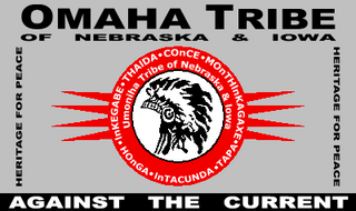
The Omaha are a federally recognized Midwestern Native American tribe who reside on the Omaha Reservation in northeastern Nebraska and western Iowa, United States. There were 5,427 enrolled members as of 2012. The Omaha Reservation lies primarily in the southern part of Thurston County and northeastern Cuming County, Nebraska, but small parts extend into the northeast corner of Burt County and across the Missouri River into Monona County, Iowa. Its total land area is 307.03 sq mi (795.2 km2) and the reservation population, including non-Native residents, was 4,526 in the 2020 census. Its largest community is Pender.

Chief Blackbird was the leader of the Omaha Native American Indian tribe who commanded the trade routes used by Spanish, French, British and later American traders until the late 18th century. He was one of the first of the Plains Indian chiefs to trade with white explorers and also believed to be the first of the Plains Indian chiefs to openly question white encroachment. Blackbird used trade as a means to prosperity for his people and as a way to ensure white explorers were aware that they were the guests. The Omaha were not warlike people, yet they were the first on the Great Plains to have mastered equestrianism around 1770 and were at one point, while Chief Blackbird was alive, the most powerful Indian tribe in the Great Plains.
East Omaha is a geographically designated community located in Omaha, Nebraska. Located three miles (5 km) from downtown Omaha, East Omaha is the site of Eppley Omaha International Airport, Omaha's main airport, and Carter Lake. This area was Omaha's first annexation, joining the city in 1854.

Carter Lake is a shallow oxbow lake in Nebraska and Iowa, located next to Omaha, and marks one of the only spots the Iowa-Nebraska border is not on the Missouri River. Soon after its formation the lake was called the East Omaha Lake, and then Lake Nakoma. The city of Carter Lake, Iowa takes its name from the lake. The lake was formed from the Saratoga Bend in the Missouri River.
Saratoga Springs, Nebraska Territory, or Saratoga, was a boom and bust town founded in 1856 that thrived for several years. During its short period of influence the town grew quickly, outpacing other local settlements in the area including Omaha and Florence, and briefly considered as a candidate for the Nebraska Territorial capitol. Saratoga was annexed into Omaha in 1887, and has been regarded a neighborhood in North Omaha since then.
The neighborhoods of Omaha are a diverse collection of community areas and specific enclaves. They are spread throughout the Omaha metro area, and are all on the Nebraska side of the Missouri River.

Tourism in Omaha, Nebraska, United States offers visitors history, sports, nature and cultural experiences. Its principal tourist attractions are the Henry Doorly Zoo and the College World Series (CWS). A 2003 study by a Creighton University economist estimated that the CWS added $33.8 million to the city's economy that year. With 1.1 million visitors annually, the Henry Doorly Zoo is Nebraska's most popular tourist attraction. In 2007 Omaha hosted the USA Roller Sports National Championships, along with 10,000 people who auditioned for the American Idol television show at Qwest Center Omaha.

The Mid-America Council of the Boy Scouts of America offers programs in 58 counties in Nebraska, Iowa and South Dakota. The Mid-America Council was formed from a merger of the Covered Wagon Council and the Southwest Iowa Council in 1965. The first recorded Council in the area was in 1918 as the Omaha Council. In 2000 the council merged with the Prairie Gold Council that had been located in Sioux City, Iowa.
Abbott Drive is a roadway mostly in Omaha, Nebraska, United States, but passes briefly through Carter Lake, Iowa. It is the easternmost link in Omaha's Park and Boulevard System that connects the eastern edge of Creighton University and North Downtown Omaha or NoDo to Carter Lake, Iowa, Eppley Airfield to John J Pershing Drive on the eastern end of Florence, Nebraska. Considered "Omaha's gateway", the drive includes a distinctive "string of pearls" lighting feature.

Horseshoe Council Bluffs is a casino and former greyhound racing track in Council Bluffs, Iowa, near Omaha, Nebraska. It is owned by Vici Properties and operated by Caesars Entertainment. It has 60,000 sq ft (5,600 m2) of gaming space with 1,438 slot machines, 63 table games, a William Hill racebook, and a WSOP poker room. Accommodations are offered at an adjoining Hilton Garden Inn, and the nearby Country Inns & Suites, Holiday Inn Express and SpringHill Suites.
American Indians of Iowa include numerous Native American tribes and prehistoric cultures that have lived in this territory for thousands of years. There has been movement both within the territory, by prehistoric cultures that descended into historic tribes, and by other historic tribes that migrated into the territory from eastern territories. In some cases they were pushed by development pressure and warfare.
Gibson Bend of the Missouri River is a meander located in Pottawattamie County, Iowa and Douglas County, Nebraska, located at 41°11′15″N95°55′15″W. The Gibson neighborhood is a community area in Omaha, Nebraska abutting the Gibson Bend.

The 2011 flooding event on the Missouri River in the United States was triggered by record snowfall in Rocky Mountains of Montana and Wyoming along with near-record spring rainfall in central and eastern Montana. All six major dams along the Missouri River released record amounts of water to prevent overflow which led to flooding threatening several towns and cities along the river from Montana to Missouri; in particular Bismarck, North Dakota; Pierre, South Dakota; Dakota Dunes, South Dakota; South Sioux City, Nebraska, Sioux City, Iowa; Omaha, Nebraska; Council Bluffs, Iowa; Saint Joseph, Missouri; Kansas City, Missouri; Jefferson City, Missouri, and St. Louis, Missouri. Many smaller towns were also at risk, suffering the same fate as the larger cities if not worse. According to the National Weather Service, in the second half of the month of May 2011, almost a year's worth of rain fell over the upper Missouri River basin. Extremely heavy rainfall in conjunction with an estimated 212 percent of normal snowpack in the Rocky Mountains contributed to this flooding event.

Blackbird Hill, about three miles south of Macy, Nebraska, also known as Big Elk Hill, is a historic site which was listed on the National Register of Historic Places in 1979.
