
Fellsmere is a city in Indian River County, Florida, United States. It is part of the Sebastian–Vero Beach Metropolitan Statistical Area. The population was 4,834 at the 2020 census.

Everglades National Park is an American national park that protects the southern twenty percent of the original Everglades in Florida. The park is the largest tropical wilderness in the United States and the largest wilderness of any kind east of the Mississippi River. An average of one million people visit the park each year. Everglades is the third-largest national park in the contiguous United States after Death Valley and Yellowstone. UNESCO declared the Everglades & Dry Tortugas Biosphere Reserve in 1976 and listed the park as a World Heritage Site in 1979, and the Ramsar Convention included the park on its list of Wetlands of International Importance in 1987. Everglades is one of only three locations in the world to appear on all three lists.

The St. Johns River is the longest river in the U.S. state of Florida and it is the most significant one for commercial and recreational use. At 310 miles (500 km) long, it flows north and winds through or borders twelve counties. The drop in elevation from headwaters to mouth is less than 30 feet (9 m); like most Florida waterways, the St. Johns has a very slow flow speed of 0.3 mph (0.13 m/s), and is often described as "lazy".

The Salt River is a river in Gila and Maricopa counties in Arizona, United States, that is the largest tributary of the Gila River. The river is about 200 miles (320 km) long. Its drainage basin covers about 13,700 square miles (35,000 km2). The longest of the Salt River's many tributaries is the 195-mile (314 km) Verde River. The Salt's headwaters tributaries, the Black River and East Fork, increase the river's total length to about 300 miles (480 km). The name Salt River comes from the river's course over large salt deposits shortly after the merging of the White and Black Rivers.

The Feather River is the principal tributary of the Sacramento River, in the Sacramento Valley of Northern California. The river's main stem is about 73 miles (117 km) long. Its length to its most distant headwater tributary is just over 210 miles (340 km). The main stem Feather River begins in Lake Oroville, where its four long tributary forks join—the South Fork, Middle Fork, North Fork, and West Branch Feather Rivers. These and other tributaries drain part of the northern Sierra Nevada, and the extreme southern Cascades, as well as a small portion of the Sacramento Valley. The total drainage basin is about 6,200 square miles (16,000 km2), with approximately 3,604 square miles (9,330 km2) above Lake Oroville.

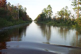
The Kissimmee River is a river in south-central Florida, United States that forms the north part of the Everglades wetlands area. The river begins at East Lake Tohopekaliga south of Orlando, flowing south through Lake Kissimmee into the large, shallow Lake Okeechobee. Hurricane-related floods in 1947 prompted channelization of the meandering lower stretch, completed by 1970. The straightened course reduced wetland habitat and worsened pollution. In response, efforts since the 1990s have partially restored the river's original state and revitalized the ecosystem, as part of the broader restoration of the Everglades.

Paynes Prairie Preserve State Park is a Florida State Park, encompassing a 21,000-acre (85 km2) savanna in Alachua County, Florida lying between Micanopy and Gainesville. It is also a U.S. National Natural Landmark. It is crossed by both I-75 and U.S. 441. It is in the center of the Paynes Prairie Basin. The basin's primary source of drainage is Alachua Sink. During occasional wet periods, the basin will become full. A notable period occurred from 1871 to 1891 when the Alachua Sink was temporarily blocked. During this period, shallow draft steamboats were a frequent sight on Alachua Lake in the center of the prairie. The region was also historically known as the Alachua Savannah. Its drainage has been modified by several canals. Since 1927, Camps Canal has linked the basin to the River Styx which leads to Orange Lake and eventually the Atlantic Ocean through the St. Johns River. That reduced the basins water intake by half. Additional changes to the prairie's environment have been detrimental to its hydrology. In 1970, the state of Florida acquired the land and has been in the process of restoring the environment to a more natural condition ever since.

Hontoon Island State Park is a 1,648-acre (6.67 km2) Florida State Park located on Hontoon Island between the St. Johns River and the Hontoon Dead River in Volusia County. It is six miles (10 km) west of DeLand, off SR 44, and can only be reached by boat or park-operated passenger ferry. No motorized vehicles, other than wheelchairs, are allowed to be brought onto the island and there is no swimming. The island has pine flatwoods, palm and oak hammocks, bald cypress swamps and marshes. Hontoon Island is surrounded by the St. Johns River, the Hontoon Dead River, and Snake Creek.

The Okefenokee National Wildlife Refuge is a 402,000‑acre (1,627 km2) National Wildlife Refuge located in Charlton, Ware, and Clinch Counties of Georgia, and Baker County in Florida, United States. The refuge is administered from offices in Folkston, Georgia. The refuge was established in 1937 to protect a majority of the 438,000 acre (1,772 km2) Okefenokee Swamp. The name "Okefenokee" is a Native American word meaning "trembling earth."
Lake Louisa State Park is a 4,372-acre (17.69 km2) Florida State Park located south of Clermont, in the northeast corner of the Green Swamp and the southwestern shore of Lake Louisa. It is made up of bald cypress, live oak, and saw palmettos. In addition to Lake Louisa, the park contains Hammond Lake, Dixie Lake, Dude Lake, and Bear Lake, along with several smaller lakes.

Wekiwa Springs State Park is a 7,000-acre (28 km2) Florida State Park in Apopka, Florida. It is located 20 minutes north of Orlando, off Interstate 4 at exit 94, near Altamonte Springs and Longwood. The park also contains the head water of the Wekiva River. It also serves as the headquarters of one of the state's five AmeriCorps Florida State Parks chapters.
The Wekiva River is a 16.0-mile-long (25.7 km) river in Central Florida, north of Orlando in the United States. It originates in Apopka and joins the St. Johns River, the longest river in the state, in DeBary. The Wekiva River system includes the main stem joined by three main tributaries - Rock Springs Run, Blackwater Creek, and the Little Wekiva River - and about 30 contributing groundwater springs. It is designated as a Florida State Canoe Trail, an Outstanding Florida Water, and an Aquatic Preserve by the Florida Department of Environmental Protection. The Wekiva River system is also one of the two rivers in Florida federally designated as a National Wild and Scenic River for its scenery, recreation, geology, and diverse habitats.

Lake Tohopekaliga, Tohopeka ; Tohopekaliga, also referred to as Lake Toho, West Lake, or simply Toho, is the largest lake in Osceola County, Florida, United States. It is the primary inflow of Shingle Creek, which rises in Orlando. It covers 22,700 acres (91.86 km2), and spans 42 miles (68 km) in circumference. It is linked to East Lake Tohopekaliga by Canal 31. The canal is 3 miles (5 km) long and runs through western St. Cloud. South Port canal is located at the southern tip of the lake and links it to Cypress Lake. It is 4 miles (6 km) long. Lake Toho is bordered on the northern shore by Kissimmee, on the eastern shore by Kissimmee Park, and South Port on the southern shore. Lake Tohopekaliga is known for its bass fishing and birdwatching. Lakefront Park is located at the North end of the lake and borders Lakeshore Blvd. Lakefront Park has a scenic walking path with benches where visitors may view the area's wide array of waterfowl, alligators, turtles and others. Lakefront park also has a miniature lighthouse, a children's playground area, and is bordered on its west end by Big Toho Marina.

East Lake Tohopekaliga is a lake in Osceola County, Florida, United States. It is the primary inflow of Boggy Creek, which rises in the Orlando International Airport at 70 feet (21 m) above sea level. Three places surround the lake, they are St. Cloud on the south shore, Narcoossee and Runnymede on the east shore.

The Lake George State Forest is a designated protected area and state forest in the U.S. state of Florida. The 21,176-acre (8,570 ha) forest is located in northwestern Volusia County, Florida, near Lake George and the communities of Pierson, Barberville, and Volusia. It is overseen by the Florida Forest Service within the Florida Department of Agriculture and Consumer Services.
Bull Creek is a rural unincorporated community in Osceola County, Florida, United States. It is located approximately 7 miles (11 km) east of Holopaw and 30 miles (48 km) west of Melbourne.

Water and Woods Field Service Council was a field service council of the Michigan Crossroads Council that served youth in the central and northeastern Lower Peninsula of Michigan. The Council was headquartered in Flint, Michigan, with service centers located in Auburn, Lansing, and Port Huron. The Water and Woods Field Service Council was the result of a merger in 2012 of Lake Huron Area Council, Blue Water Council, Tall Pine Council and Chief Okemos Council.
Orange Creek is a small stream in north-central and northeast Florida, that drains Orange Lake to the Ocklawaha River. Privately owned Orange Springs provides part of the water volume.


