Booneville, Arkansas

Last updated

Booneville, Arkansas
Booneville Commercial Historic District, 2 of 3.JPG
Booneville commercial downtown district
Logan County Arkansas Incorporated and Unincorporated areas Booneville Highlighted 0507720.svg
Location of Booneville in Logan County, Arkansas.
Coordinates: 35°08′21″N93°55′04″W / 35.13917°N 93.91778°W / 35.13917; -93.91778
Country United States
State Arkansas
County Logan
Established1828
Incorporated1878, 1899
Area
[1]
  Total3.96 sq mi (10.26 km2)
  Land3.94 sq mi (10.21 km2)
  Water0.02 sq mi (0.05 km2)
Elevation
[2]
482 ft (147 m)
Population
 (2020)
  Total3,809
  Density965.77/sq mi (372.92/km2)
Time zone UTC−06:00 (Central (CST))
  Summer (DST) UTC−05:00 (CDT)
ZIP Code
72927
Area code 479
FIPS code 05-07720
GNIS feature ID2403896 [2]

Booneville is a city in Logan County, Arkansas, United States and the county seat of its southern district. [3] Located in the Arkansas River Valley between the Ouachita and Ozark Mountains, the city is one of the oldest in western Arkansas. The city's economy was first based upon the railroad and Arkansas State Tuberculosis Sanatorium. It has developed a diverse economy of small businesses and light industry. Booneville's population was 3,990 at the 2010 census.

Contents

Booneville supports a community center, a senior-citizens center, a community hospital, a municipal airport, and new school facilities. Hunting, fishing, camping, hiking, and other outdoors activities are readily available in nearby national forests and state parks.

History

Naming

The city was founded in 1828 when Walter Cauthron, an early explorer of the Arkansas Territory, built a log cabin and store along the Petit Jean River. By some accounts, he intended to name the community as "Bonneville" for friend Benjamin Bonneville, but the spelling and name were later changed. Another theory is that the name was to honor Daniel Boone, a friend of the Logan family for whom the county is named. [4]

2008 explosion of meat-packing plant

On March 23, 2008, A fire set off multiple explosions at the Cargill Meat Solutions plant in Booneville. According to local authorities the explosions caused an ammonia gas leak that forced 180 people from their homes. There were no reported injuries of the accident. The fire was reportedly started from an accident caused by welders doing repairs on fans in a freezer section. The Cargill Meat plant was the towns largest employer at the time of the explosions. [5]

Geography

According to the United States Census Bureau, the city has a total area of 4.1 square miles (11 km2), all land.

Booneville is near Blue Mountain Lake, a lake popular for fishing, boating, and swimming. Five United States Army Corps of Engineers recreation areas are available for public lake access. At the east end of the lake, the Blue Mountain Wildlife Demonstration Area is a world-class bird-dog field area. This area also hosts visitors interested in hiking, birding, and mountain bike riding.

Climate

Climate data for Booneville, Arkansas (1991–2020 normals, extremes 1915–present)
MonthJanFebMarAprMayJunJulAugSepOctNovDecYear
Record high °F (°C)84
(29)
87
(31)
94
(34)
96
(36)
99
(37)
111
(44)
114
(46)
118
(48)
112
(44)
100
(38)
89
(32)
83
(28)
118
(48)
Average high °F (°C)50.0
(10.0)
55.2
(12.9)
63.5
(17.5)
72.5
(22.5)
79.5
(26.4)
87.2
(30.7)
92.1
(33.4)
91.9
(33.3)
84.8
(29.3)
74.5
(23.6)
62.2
(16.8)
52.4
(11.3)
72.1
(22.3)
Daily mean °F (°C)39.0
(3.9)
43.1
(6.2)
51.0
(10.6)
59.8
(15.4)
68.6
(20.3)
76.6
(24.8)
81.0
(27.2)
80.1
(26.7)
73.0
(22.8)
62.0
(16.7)
50.2
(10.1)
41.5
(5.3)
60.5
(15.8)
Average low °F (°C)28.0
(−2.2)
31.1
(−0.5)
38.5
(3.6)
47.2
(8.4)
57.7
(14.3)
65.9
(18.8)
69.9
(21.1)
68.4
(20.2)
61.3
(16.3)
49.5
(9.7)
38.1
(3.4)
30.7
(−0.7)
48.9
(9.4)
Record low °F (°C)−18
(−28)
−6
(−21)
5
(−15)
22
(−6)
30
(−1)
45
(7)
49
(9)
41
(5)
32
(0)
18
(−8)
8
(−13)
−9
(−23)
−18
(−28)
Average precipitation inches (mm)3.75
(95)
3.20
(81)
4.78
(121)
5.04
(128)
5.82
(148)
4.24
(108)
3.56
(90)
3.49
(89)
4.39
(112)
4.40
(112)
4.62
(117)
4.35
(110)
51.64
(1,312)
Average precipitation days (≥ 0.01 in)7.67.69.58.710.48.08.17.07.27.98.07.997.9
Source: NOAA [6] [7]

Demographics

2020 census

Historical population
CensusPop.Note
1880 275
1890 49680.4%
1900 98899.2%
1910 1,63165.1%
1920 2,19934.8%
1930 2,099−4.5%
1940 2,32410.7%
1950 2,4334.7%
1960 2,69010.6%
1970 3,23920.4%
1980 3,71814.8%
1990 3,8042.3%
2000 4,1178.2%
2010 3,990−3.1%
2020 3,809−4.5%
U.S. Decennial Census [8]
2014 Estimate [9]
Booneville racial composition [10]
RaceNumberPercentage
White (non-Hispanic)3,34687.84%
Black or African American (non-Hispanic)220.58%
Native American 611.6%
Asian 240.63%
Pacific Islander 10.03%
Other/Mixed 2185.72%
Hispanic or Latino 1373.6%

As of the 2020 United States census, there were 3,809 people, 1,439 households, and 855 families residing in the city.

2000 census

As of the census [11] of 2000, 4,117 people, 1,619 households, and 1,109 families were residing in the city. The population density was 1,010.0 inhabitants per square mile (390.0/km2). The 1,863 housing units averaged 457.0 per square mile (176.3/km2). The racial makeup of the city was 96.62% White, 0.05% African American, 1.12% Native American, 0.27% Asian, 0.05% Pacific Islander, 0.17% from other races, and 1.72% from two or more races. About 0.87% of the population was Hispanic or Latino of any race.

Of the 1,619 households, 34.8% had children under the age of 18 living with them, 51.3% were married couples living together, 13.3% had a female householder with no husband present, and 31.5% were not families. About 28.5% of all households were made up of individuals, and 16.2% had someone living alone who was 65 years of age or older. The average household size was 2.48, and the average family size was 3.01.

In the city, the population was distributed as 28.0% under the age of 18, 8.1% from 18 to 24, 26.4% from 25 to 44, 20.0% from 45 to 64, and 17.5% who were 65 years of age or older. The median age was 36 years. For every 100 females, there were 88.9 males. For every 100 females age 18 and over, there were 82.1 males.

The median income for a household in the city was $26,627, and for a family was $31,012. Males had a median income of $25,238 versus $20,092 for females. The per capita income for the city was $13,076. About 13.1% of families and 18.4% of the population were below the poverty line, including 22.0% of those under age 18 and 23.9% of those age 65 or over.

Education

First grade class standing in front of Booneville Elementary School, former Booneville Co-Educational Institute, 1954 Parish 1st Grade Class 1954.jpg
First grade class standing in front of Booneville Elementary School, former Booneville Co-Educational Institute, 1954

From its early days, Booneville has supported education. In 1874, as a response to needs for higher learning in western Arkansas, the Fort Smith District of the Methodist Episcopal Church, South, authorized the establishment of the Fort Smith District High School in Booneville, 40 miles to the west. Local church members donated the land, building materials, and labor. The school, located on South College Street, was to be supported by student tuition fees. Students came from towns all over western Arkansas to board with Booneville families and attend a school that offered an advanced curriculum, including Latin, German, advanced mathematics, literature, and music. The school functioned until the early 1900s.

After the school closed, a group of residents and business leaders formed the Booneville Education Association and acquired 9 acres (36,000 m2) of land in the northwest part of town. The new school was called the Booneville Co-Educational Institute and also offered a more advanced curriculum than the public school around. Graduates were admitted as sophomores at the University of Arkansas at Fayetteville.

In 1920, state funds were made available for the support of public high schools and the school's property was transferred to the Booneville School District. The building continued to be used as the city's high school until a new building was built in 1929. The old Co-Educational Institute building was used as the Booneville elementary school for several decades after that. [12]

Infrastructure

Transportation

Highway 23 in downtown Booneville Booneville Commercial Historic District, 1 of 3.JPG
Highway 23 in downtown Booneville

The city is located at the intersection of Highway 23 (commonly known as the "Pig Trail") and Highway 10. Both routes are designated as Arkansas Scenic Byways near Booneville. Highway 217 also runs north and south from the city.

Rights-of-way for downtown city streets dedicated during the original town plat are wider than in most communities.

Water/wastewater

The city of Booneville owns the Booneville Water Department, which treats and distributes potable water from Lake Booneville to the residents and commercial users of the city in accordance with Arkansas Department of Health regulations. [13]

The Booneville Water Department also collects and treats wastewater in accordance with a Clean Water Act National Pollutant Discharge Elimination System permit issued and administrated by the Arkansas Department of Environmental Quality. [14] Treated effluent is discharged to Booneville Creek, ultimately draining to the Arkansas River. [14]

Notable people

Related Research Articles

<span class="mw-page-title-main">Logan County, Arkansas</span> County in Arkansas, United States

Logan County is a county located in the U.S. state of Arkansas. As of the 2020 census, the population was 21,131. Its two county seats are Booneville and Paris.

<span class="mw-page-title-main">Benton County, Arkansas</span> County in Arkansas, United States

Benton County is a county within the Northwest Arkansas region with a culture, economy, and history that have transitioned from rural and agricultural to suburban and white collar since the growth of Walmart, which is headquartered in Benton County. Created as Arkansas's 35th county on September 30, 1836, Benton County contains thirteen incorporated municipalities, including Bentonville, the county seat, and Rogers, the most populous city. The county was named after Thomas Hart Benton, a U.S. Senator from Missouri influential in Arkansas statehood.

<span class="mw-page-title-main">Bella Vista, Arkansas</span> City in Arkansas, United States

Bella Vista is a city in Benton County, Arkansas, United States. First established in 1917 as a summer resort destination, Bella Vista has evolved and redesigned itself over the succeeding years. Bella Vista became a retirement community in 1965, and, after much contention and a 2006 vote of its property owners, became an incorporated city.

<span class="mw-page-title-main">Lowell, Arkansas</span> City in Arkansas, United States

Lowell is a city in Benton County, Arkansas, United States. Located within the Ozarks, first settlement was along Old Wire Road in the 1840s, and although destroyed during the Civil War, the community was reestablished by J. R. McClure and thrived when the St. Louis–San Francisco Railway came through the area in the 1880s. Today, the city is a growing bedroom community within the rapidly growing Northwest Arkansas region. Lowell is also home to the headquarters of trucking company J.B. Hunt. Lowell's population was 9,839 at the 2020 census, an increase of 34% since 2010.

<span class="mw-page-title-main">Lake City, Arkansas</span> City in Arkansas, United States

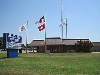
Lake City is a city in Craighead County, Arkansas, United States, along the St. Francis River. Lake City is one of two county seats in Craighead County. The population was 2,326 as of the 2020 census. It is included in the Jonesboro, Arkansas Metropolitan Statistical Area.

<span class="mw-page-title-main">Alma, Arkansas</span> City in Arkansas, United States

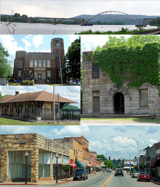
Alma is a city in Crawford County, Arkansas, United States. It is located within the Arkansas River Valley at the edge of the Ozark Mountains; the city is the sixth largest in the Fort Smith metropolitan area. The population was 5,419 at the 2010 Census. The city is located at the intersection of Interstates 40 and 49.

<span class="mw-page-title-main">Altus, Arkansas</span> City in Arkansas, United States

Altus is a city in Franklin County, Arkansas, United States. Located within the Arkansas River Valley at the edge of the Ozark Mountains, the city is within the Fort Smith metropolitan area. The epicenter of the Altus American Viticultural Area (AVA) within Arkansas Wine Country, the city is home to four wineries. Although founded as a coal mining community, the wine industry has driven the Altus economy since the first vineyards were planted in 1872. The population was 758 at the 2010 census, down from 817 at the 2000 census.

<span class="mw-page-title-main">Ozark, Arkansas</span> City in Arkansas, United States

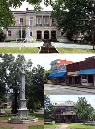
Ozark is a city in Franklin County, Arkansas, United States and one of the county's two seats of government. The community is located along the Arkansas River in the Arkansas River Valley on the southern edge of the Ozark Mountains. As of the 2010 census it had a population of 3,684.

<span class="mw-page-title-main">Marianna, Arkansas</span> Town in Arkansas, United States

Marianna is a town in and the county seat of Lee County, Arkansas, United States. As of the 2010 census it had a population of 4,115, but by 2018 the population had dropped to an estimated 3,477.

<span class="mw-page-title-main">Blue Mountain, Arkansas</span> Town in Arkansas, United States

Blue Mountain is a town in Logan County, Arkansas, United States. The population was 124 at the 2010 census.

<span class="mw-page-title-main">Morrison Bluff, Arkansas</span> Town in Arkansas, United States

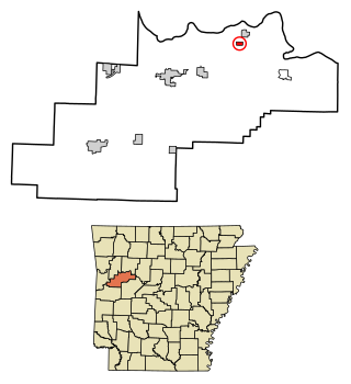
Morrison Bluff is a town in Logan County, Arkansas, United States. The population was 64 at the 2010 census and an estimated 81 in 2017.

<span class="mw-page-title-main">Paris, Arkansas</span> City in Arkansas, United States

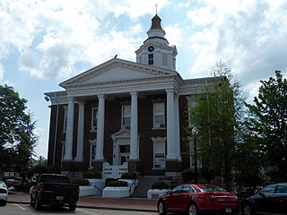
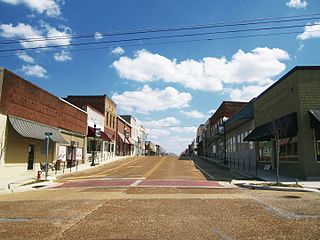
Paris is a city in Logan County, Arkansas, United States, and serves as the county seat for the northern district of Logan County; its southern district counterpart is Booneville. Its population was 3,176 as of the 2020 U.S. Census.

<span class="mw-page-title-main">Scranton, Arkansas</span> City in Arkansas, United States

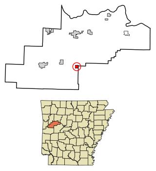
Scranton is a city in Logan County, Arkansas, United States. The population was 224 at the 2010 census. It was named after Scranton, Pennsylvania.

<span class="mw-page-title-main">Maumelle, Arkansas</span> City in Arkansas, United States

Maumelle is a city in Pulaski County, Arkansas, United States. As of the 2020 census, the city's population was 19,251. The city is located northwest of Little Rock, bordering the opposite shore of the Arkansas River and is part of the Little Rock metropolitan area.

<span class="mw-page-title-main">Bryant, Arkansas</span> City in Arkansas, United States

Bryant is a city in Saline County, Arkansas, United States and a suburb of Little Rock. According to the 2010 Census, the population of the city was 16,688. It is part of the Central Arkansas region.

<span class="mw-page-title-main">Clinton, Arkansas</span> City in Arkansas, United States

Clinton is the county seat of Van Buren County, Arkansas, United States. The population was 2,602 at the 2010 census, making it the most populous city in the county. The city was named for DeWitt Clinton, the New York governor who built the Erie Canal; he had also been a U.S. Senator from New York.

<span class="mw-page-title-main">Havana, Arkansas</span> City in Arkansas, United States

Havana is a city in northwest Yell County, Arkansas, United States. The population was 375 at the 2010 census. It is part of the Russellville Micropolitan Statistical Area. Arkansas Scenic State Highway 309 leads from Havana to the top of Mount Magazine, home of Arkansas's newest State Park, and the highest peak in Arkansas.

<span class="mw-page-title-main">Booneville, Mississippi</span> City in Mississippi, United States

Booneville is a city in the U.S. state of Mississippi and is the county seat of Prentiss County. It is located in the hilly North Mississippi region, and ecologically is part of the Southeastern Plains region.

<span class="mw-page-title-main">Logan, Ohio</span> City in Ohio, United States

Logan is a city in and county seat of Hocking County, Ohio, United States, along the on the Hocking River about 43 miles (69 km) southeast of Columbus. The population was 7,296 at the time of the 2020 census. The current mayor of Logan is Republican Greg Fraunfelter, who began a four-year term in January 2016 and was re-elected in 2019.

<span class="mw-page-title-main">Baldwyn, Mississippi</span> City in Mississippi, United States

Baldwyn is a city located in Lee and Prentiss counties, Mississippi, located in the northern part of the Tupelo micropolitan area. The population was 3,071 at the 2020 census.

References

  1. "2020 U.S. Gazetteer Files". United States Census Bureau. Retrieved October 29, 2021.
  2. 1 2 U.S. Geological Survey Geographic Names Information System: Booneville, Arkansas
  3. "Find a County". National Association of Counties. Archived from the original on May 31, 2011. Retrieved June 7, 2011.
  4. Curry, Patricia L. (October 24, 2011). "Booneville (Logan County)". Encyclopedia of Arkansas History and Culture . Butler Center for Arkansas Studies at the Central Arkansas Library System . Retrieved March 14, 2015.
  5. "Meatpacking plant explodes in Arkansas". NBC News. March 23, 2008. Retrieved September 18, 2022.
  6. "NowData – NOAA Online Weather Data". National Oceanic and Atmospheric Administration. Retrieved June 20, 2021.
  7. "Station: Booneville 3 SSE, AR". U.S. Climate Normals 2020: U.S. Monthly Climate Normals (1991-2020). National Oceanic and Atmospheric Administration. Retrieved June 20, 2021.
  8. "Census of Population and Housing". Census.gov. Retrieved June 4, 2015.
  9. "Annual Estimates of the Resident Population for Incorporated Places: April 1, 2010 to July 1, 2014". Archived from the original on May 22, 2015. Retrieved June 4, 2015.
  10. "Explore Census Data". data.census.gov. Retrieved January 1, 2022.
  11. "U.S. Census website". United States Census Bureau . Retrieved January 31, 2008.
  12. Booneville Democrat, Special Edition, June 30, 1999, Pg. 13
  13. "Booneville Water Department" (PDF). Annual Drinking Water Quality Report. ADH. 2013. Retrieved March 14, 2015.[ permanent dead link ]
  14. 1 2 "Authorization to Discharge Wastewater Under the National Pollutant Discharge Elimination System and the Arkansas Water and Air Pollution Control Act". NPDES Permit AR-0021571. ADEQ. April 23, 2013.{{cite web}}: Missing or empty |url= (help)