DeWitt, Arkansas

Last updated

DeWitt, Arkansas
Arkansas County Courthouse-Southern District.jpg
Arkansas County Arkansas Incorporated and Unincorporated areas DeWitt Highlighted 0518790.svg
Location of DeWitt in Arkansas County, Arkansas.
Coordinates: 34°17′29″N91°20′13″W / 34.29139°N 91.33694°W / 34.29139; -91.33694
Country United States
State Arkansas
County Arkansas
IncorporatedJanuary 26, 1876 [1]
Government
  Type Mayor–council
Area
[2]
  Total2.99 sq mi (7.75 km2)
  Land2.99 sq mi (7.75 km2)
  Water0.00 sq mi (0.00 km2)
Elevation
190 ft (58 m)
Population
 (2020)
  Total3,056
  Density1,021.39/sq mi (394.32/km2)
Time zone UTC-6 (Central (CST))
  Summer (DST) UTC-5 (CDT)
ZIP code
72042
Area code 870
FIPS code 05-18790
GNIS feature ID0048411

DeWitt is the second largest city in Arkansas County, Arkansas, United States, which also serves as the county seat of the southern district of Arkansas County. Population was 3,292 at the time of the 2010 census. [3] The city is located on the Arkansas Grand Prairie, known for rice farming and duck hunting. DeWitt is home to the DeWitt School District and the DeWitt Municipal Airport.

Contents

History

The Arkansas County Quorum Court determined Arkansas Post, which had served as county seat since 1813, was no longer centrally located within the county following creation of several Southeast Arkansas counties. A new, more centrally located town was proposed to become county seat. Founded February 19, 1853, the name DeWitt was picked out of a hat after being submitted by an admirer of the sixth governor of New York, DeWitt Clinton, one of many localities named for Clinton during the period. The town was platted in 1854, [4] and has had a post office since 1856. [5] The city was incorporated in 1875. [4]

Geography

DeWitt and Arkansas County are located in the Arkansas Delta (in Arkansas, usually referred to as "the Delta") a subregion of the Mississippi Alluvial Plain, which is a flat area consisting of rich, fertile sediment deposits from the Mississippi River between Louisiana and Illinois.

Within the Delta, Arkansas County is almost entirely within the Grand Prairie subregion, historically a flat grassland plain underlain by an impermeable clay layer (the Stuttgart soil series). Prior to the 19th century, flatter areas with slowly to very slowly permeable soils (often containing fragipans) supported Arkansas's largest prairie, covered in prairie grasses and forbs, with oaks covering the low hills and ridges, and pockets of floodplains with bottomland hardwood forests. This region was a sharp contrast to the bottomland forests that once dominated other parts of the Mississippi Alluvial Plain. Cropland has now largely replaced the native vegetation. Distinctively, rice is the main crop; soybeans, cotton, corn, and wheat are also grown. The rice fields provide habitat and forage for large numbers and many species of waterfowl; duck and goose hunting occurs at this important spot along the Mississippi Flyway. [6]

DeWitt is located at 34°17′29″N91°20′13″W / 34.29139°N 91.33694°W / 34.29139; -91.33694 (34.291477, -91.336983). [7] According to the United States Census Bureau, the city has a total area of 2.6 square miles (6.7 km2), all land.

Demographics

Historical population
CensusPop.Note
1880 169
1890 24645.6%
1900 31829.3%
1910 831161.3%
1940 2,498
1950 2,84313.8%
1960 3,0196.2%
1970 3,72823.5%
1980 3,9285.4%
1990 3,553−9.5%
2000 3,5520.0%
2010 3,292−7.3%
2020 3,056−7.2%
U.S. Decennial Census [8]
2014 Estimate [9]

2020 census

DeWitt racial composition [10]
RaceNumberPercentage
White (non-Hispanic)2,15370.45%
Black or African American (non-Hispanic)61920.26%
Native American 40.13%
Asian 200.65%
Pacific Islander 10.03%
Other/Mixed 1444.71%
Hispanic or Latino 1153.76%

As of the 2020 United States census, there were 3,056 people, 1,226 households, and 730 families residing in the city.

2010 census

As of the 2010 United States Census, there were 3,292 people living in the city. 74.5% were White, 21.4% African American, 0.3% Native American, 0.4% Asian, 2.1% from some other race and 1.4% from two or more races. 3.2% were Hispanic or Latino of any race.

2000 census

As of the census [11] of 2000, there were 3,552 people, 1,419 households, and 977 families living in the city. The population density was 1,371.7 inhabitants per square mile (529.6/km2). There were 1,552 housing units at an average density of 599.4 per square mile (231.4/km2). The racial makeup of the city was 77.93% White, 20.92% Black or African American, 0.17% Native American, 0.23% Asian, 0.20% from other races, and 0.56% from two or more races. 0.53% of the population were Hispanic or Latino of any race.

There were 1,419 households, out of which 32.2% had children under the age of 18 living with them, 47.2% were married couples living together, 18.3% had a female householder with no husband present, and 31.1% were non-families. 27.1% of all households were made up of individuals, and 14.4% had someone living alone who was 65 years of age or older. The average household size was 2.35 and the average family size was 2.84.

In the city, the population was spread out, with 24.5% under the age of 18, 8.3% from 18 to 24, 26.0% from 25 to 44, 22.1% from 45 to 64, and 19.0% who were 65 years of age or older. The median age was 39 years. For every 100 females, there were 87.1 males. For every 100 females age 18 and over, there were 79.1 males.

The median income for a household in the city was $30,921, and the median income for a family was $42,917. Males had a median income of $30,536 versus $25,240 for females. The per capita income for the city was $18,993. About 10.6% of families and 18.2% of the population were below the poverty line, including 25.0% of those under age 18 and 14.4% of those age 65 or over.

Education

DeWitt is the center of the DeWitt School District and is home to DeWitt High School, DeWitt Middle School, DeWitt Elementary School, and Gillett Elementary School. Their mascot is the Dragons, and their school colors are blue and gold. DeWitt High School houses grades 9 through 12. DeWitt Middle School houses grades 6 through 8, and both DeWitt Elementary and Gillett Elementary provide kindergarten through 5th grade.

Culture and contemporary life

Streetside in the DeWitt Commercial Historic District DeWitt Commercial Historic District, 1 of 7.jpg
Streetside in the DeWitt Commercial Historic District

The city contains eight listings on the National Register of Historic Places. The DeWitt Commercial Historic District contains 54 historically significant buildings, 32 of which face Courthouse Square, including the Arkansas County Courthouse-Southern District itself. The L.A. Black Rice Milling Association Inc. Office and Halliburton House preserve historical associations with prominent local officials. The DeWitt Post Office contains New Deal-era murals. Three historic bridges are also listed in the city: Maxwell Street Bridge, North Jackson Street Bridge, and the North Washington Street Bridge.

In September 2011, the feature film Mud (2013; written and directed by Jeff Nichols, starring Reese Witherspoon and Matthew McConaughey) was filmed in and around Arkansas County. The movie featured a scene filmed at DeWitt Hospital & Nursing Home.

Annual cultural events

Perhaps the most popular annual event in DeWitt is duck hunting season between November and January, a tradition dating back to the Illinois Indians who traveled south to Arkansas to hunt, popular with Arkansans and tourist hunters from across the country.

The Arkansas County Fair has been held annually since 1938 at the Arkansas County Fairgrounds in DeWitt during mid-September.

Media

DeWitt has been served by the DeWitt Era Enterprise since 1929. Several other newspapers have been published in the city, many during the late 19th century. [12]

Infrastructure

DeWitt Municipal Airport DeWitt 5M1.jpg
DeWitt Municipal Airport

The primary highway in DeWitt is U.S. Route 165 (US 165), which connects the city to Stuttgart (the county seat of Arkansas County's northern district) and Little Rock, Arkansas to the north and Dumas, Arkansas and Louisiana to the south. Highway 1 (AR 1) runs along the city's eastern side, with Highway 1 Business (AR 1B) passing through downtown DeWitt. Other minor highways include AR 152 (2nd Street) and AR 130. AR 980 gives access to the DeWitt Municipal Airport, a general aviation facility. [13]

The Great River Road, a National Scenic Byway following the Mississippi River, passes through DeWitt. It enters the city from the south on US 165 and turns onto AR 1 toward St. Charles.

Notable people

Related Research Articles

<span class="mw-page-title-main">Washington County, Arkansas</span> County in Arkansas, United States

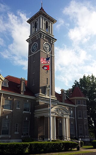
Washington County is a regional economic, educational, and cultural hub in the Northwest Arkansas region. Created as Arkansas's 17th county on November 30, 1848, Washington County has 13 incorporated municipalities, including Fayetteville, the county seat, and Springdale. The county is also the site of small towns, bedroom communities, and unincorporated places. The county is named for George Washington, the first President of the United States.

<span class="mw-page-title-main">Pulaski County, Arkansas</span> County in Arkansas, United States

Pulaski County is a county in the U.S. state of Arkansas. With a population of 399,125 as of the 2020 United States Census, it is the most populous county in Arkansas. The county is included in the Little Rock–North Little Rock–Conway metropolitan area. Its county seat is Little Rock, which is also Arkansas's capital and largest city.

<span class="mw-page-title-main">Prairie County, Arkansas</span> County in Arkansas, United States

Prairie County is in the Central Arkansas region of the U.S. state of Arkansas. The county is named for the Grand Prairie, a subregion of the Arkansas Delta known for rice cultivation and aquaculture that runs through the county. Created as Arkansas's 54th county in 1846, Prairie County is home to four incorporated towns, including DeValls Bluff, the southern district county seat, and two incorporated cities, including Des Arc, the northern district county seat. The county is also the site of numerous unincorporated communities and ghost towns. Occupying 676 square miles (175,000 ha), Prairie County is the median-sized county in Arkansas. As of the 2020 Census, the county's population was 8,282. Based on population, the county is the ninth-smallest county of the 75 in Arkansas.

<span class="mw-page-title-main">Phillips County, Arkansas</span> County in Arkansas, United States

Phillips County is a county located in the eastern part of the U.S. state of Arkansas, in what is known as the Arkansas Delta along the Mississippi River. As of the 2020 census, the population was 16,568. The county seat is Helena–West Helena.

<span class="mw-page-title-main">Monroe County, Arkansas</span> County in Arkansas, United States

Monroe County is located in the Arkansas Delta in the U.S. state of Arkansas. The county is named for James Monroe, the fifth President of the United States. Created as Arkansas's 20th county on November 2, 1829, Monroe County is home to two incorporated towns and three incorporated cities, including Clarendon, the county seat, and Brinkley, the most populous city. The county is also the site of numerous unincorporated communities and ghost towns.

<span class="mw-page-title-main">Mississippi County, Arkansas</span> County in Arkansas, United States

Mississippi County is the easternmost county in the U.S. state of Arkansas. As of the 2020 census, the population was 40,685. There are two county seats, Blytheville and Osceola. The county is named for the Mississippi River which borders the county to the east. Mississippi County is part of the First Congressional District in Arkansas.

<span class="mw-page-title-main">Lonoke County, Arkansas</span> County in Arkansas, United States

Lonoke County is located in the Central Arkansas region of the U.S. state of Arkansas. As of the 2020 census, the population was 74,015, making it the 10th-most populous of Arkansas's 75 counties. The county seat is Lonoke and largest city is Cabot. Included in the Central Arkansas metropolitan area, with Little Rock as the principal city, it is an alcohol prohibition or dry county.

<span class="mw-page-title-main">Logan County, Arkansas</span> County in Arkansas, United States

Logan County is a county located in the U.S. state of Arkansas. As of the 2020 census, the population was 21,131. Its two county seats are Booneville and Paris.

<span class="mw-page-title-main">Lafayette County, Arkansas</span> County in Arkansas, United States

Lafayette County is a county located in the U.S. state of Arkansas. As of the 2020 census, the population was 6,308, making it the third-least populous county in Arkansas. The county seat is Lewisville. Lafayette County was formed on October 15, 1827, and named in honor of the Marquis de Lafayette, a French military hero of the American Revolutionary War. It is a dry county; therefore, the sale of alcohol is prohibited.

<span class="mw-page-title-main">Hot Spring County, Arkansas</span> County in Arkansas, United States

Hot Spring County is located in the U.S. state of Arkansas. As of the 2020 census, the population was 33,040. The county seat is Malvern. Hot Spring County was formed on November 2, 1829, from a portion of Clark County. It was named for the hot springs at Hot Springs, Arkansas, which were within its boundaries until Garland County was formed in 1873.

<span class="mw-page-title-main">Franklin County, Arkansas</span> County in Arkansas, United States

Franklin County is a county in Arkansas. As of the 2020 census, the population was 17,097. The county has two county seats, Charleston and Ozark. The county was formed on December 19, 1837, and named for Benjamin Franklin, American statesman. Franklin County is a damp county, with alcohol sales allowed except in Prairie & Alix townships, and limits on liquor sales in the city of Branch.

<span class="mw-page-title-main">Crittenden County, Arkansas</span> County in Arkansas, United States

Crittenden County is a county located in the U.S. state of Arkansas. As of the 2020 census, the population was 48,163. The county seat is Marion, and the largest city is West Memphis.

<span class="mw-page-title-main">Cleveland County, Arkansas</span> County in Arkansas, United States

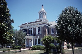
Cleveland County is a county located in the U.S. state of Arkansas. Its population was 7,550 at the 2020 U.S. census. The county seat and largest city is Rison.

<span class="mw-page-title-main">Benton County, Arkansas</span> County in Arkansas, United States

Benton County is a county within the Northwest Arkansas region with a culture, economy, and history that have transitioned from rural and agricultural to suburban and white collar since the growth of Walmart, which is headquartered in Benton County. Created as Arkansas's 35th county on September 30, 1836, Benton County contains thirteen incorporated municipalities, including Bentonville, the county seat, and Rogers, the most populous city. The county was named after Thomas Hart Benton, a U.S. Senator from Missouri influential in Arkansas statehood.

<span class="mw-page-title-main">Arkansas County, Arkansas</span> County in Arkansas, United States

Arkansas County is a county located in the U.S. state of Arkansas. As of the 2020 census, the population was 17,149. Located in the Arkansas Delta, the county has two county seats, DeWitt and Stuttgart.

<span class="mw-page-title-main">Stuttgart, Arkansas</span> City in Arkansas

Stuttgart is a city in and the county seat of the northern district of Arkansas County, Arkansas, United States. Established by German settlers, it was named for its larger German counterpart. Known as the "Rice and Duck Capital of the World", the city is an international destination for waterfowl hunting along the Mississippi Flyway. Stuttgart is the most important city on the Arkansas Grand Prairie, a region known for rice cultivation. The economy is largely based on agricultural production, waterfowl tourism, and supporting industries. As of the 2010 census it had a population of 9,326.

<span class="mw-page-title-main">DeValls Bluff, Arkansas</span> City in Arkansas, United States

DeValls Bluff is a city in and the county seat of the southern district of Prairie County, Arkansas, United States. The population was 619 at the 2010 census.

<span class="mw-page-title-main">Des Arc, Arkansas</span> City in Arkansas, United States

Des ArcDEZ-ark is a city on the White River in the Arkansas Delta, United States. It is the largest city in Prairie County, Arkansas, and the county seat for the county's northern district. Incorporated in 1854, Des Arc's position on the river has shaped its culture, history, and economy, beginning as a major lumber shipping port but leaving the city vulnerable to major floods in 1927 and 1937. As river shipping declined, Des Arc was bypassed by railroads, Interstate highways, and much of the post-industrial society. Des Arc's history is preserved by seven listings on the National Register of Historic Places, and the region's history is interpreted at Lower White River Museum State Park. The city's population stopped growing in the 1980s and has been declining since, with a population of 1,717 at the 2010 Census.

<span class="mw-page-title-main">Central Arkansas</span> Metropolitan area in Arkansas, United States

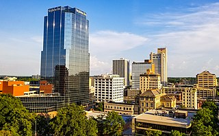
Central Arkansas, also known as the Little Rock metro, designated by the United States Office of Management and Budget as the Little Rock-North Little Rock-Conway Metropolitan Statistical Area, is the most populous metro area in the U.S. state of Arkansas. With an estimated 2020 population of 748,031, it is the most populated area in Arkansas. Located at the convergence of Arkansas's other geographic regions, the region's central location make Central Arkansas an important population, economic, education, and political center in Arkansas and the South. Little Rock is the state's capital and largest city, and the city is also home to two Fortune 500 companies, Arkansas Children's Hospital, and University of Arkansas for Medical Sciences (UAMS).

<span class="mw-page-title-main">DeWitt, Iowa</span> City in Iowa, United States

DeWitt is a city in Clinton County, Iowa, United States. The population was 5,514 at the time of the 2020 census, which represented a 9.2% increase over that of 2000, making it the fastest growing city in Clinton County.

References

  1. Scott, C. F. (July 15, 2022). "DeWitt (Arkansas County)". Encyclopedia of Arkansas . Little Rock: Butler Center for Arkansas Studies at the Central Arkansas Library System . Retrieved October 8, 2022.
  2. "2020 U.S. Gazetteer Files". United States Census Bureau. Retrieved October 29, 2021.
  3. "DeWitt city, Arkansas". US Census Bureau. Retrieved July 5, 2012.
  4. 1 2 Hempstead, Fay (1890). A Pictorial History of Arkansas: From Earliest Times to the Year 1890. Southern Historical Press. p. 830. ISBN   9780893080747. OCLC   03582896.
  5. "Post Offices". Jim Forte Postal History. Retrieved February 9, 2018.
  6. PD-icon.svg This article incorporates public domain material from Woods, A.J.; Foti, T.L.; Chapman, S.S.; Omernik, J.M.; et al. Ecoregions of Arkansas (PDF). United States Geological Survey. (color poster with map, descriptive text, summary tables, and photographs).
  7. "US Gazetteer files: 2010, 2000, and 1990". United States Census Bureau. February 12, 2011. Retrieved April 23, 2011.
  8. "Census of Population and Housing". Census.gov. Retrieved June 4, 2015.
  9. "Annual Estimates of the Resident Population for Incorporated Places: April 1, 2010 to July 1, 2014". Archived from the original on May 22, 2015. Retrieved June 4, 2015.
  10. "Explore Census Data". data.census.gov. Retrieved December 30, 2021.
  11. "U.S. Census website". United States Census Bureau . Retrieved January 31, 2008.
  12. Allsopp, Frederick W. (1922). History of the Arkansas Press for a Hundred Years and More (PDF) (Reprint ed.). Little Rock, Ark: Parke-Harper Pub. Co. pp. 48–50. ISBN   9780893080730. OCLC   3576168 via Southern Historical Press.
  13. Planning and Research Division (January 11, 2011) [September 30, 2009]. General Highway Map, Arkansas County, Arkansas (PDF) (Map). 1:62,500. Little Rock: Arkansas State Highway and Transportation Department. OCLC   908640315 . Retrieved October 8, 2022.
  14. "Wayne Eugene DuMond (1949–2005) - Encyclopedia of Arkansas". www.encyclopediaofarkansas.net. Retrieved July 22, 2018.
  15. Radcliffe, Donnie (August 24, 1993). "CLINTON'S WINDOW ON THE HOME FRONT". Washington Post. ISSN   0190-8286 . Retrieved July 28, 2018.
  16. "Frank Glasgow Tinker (1909–1939) - Encyclopedia of Arkansas". www.encyclopediaofarkansas.net. Retrieved July 22, 2018.

Further reading