Bradford, Massachusetts

Last updated

Bradford, Massachusetts
Bradford First Church of Christ.jpg
Bradford's First Church of Christ, facing the common
USA Massachusetts location map.svg
Red pog.svg
Bradford
Usa edcp location map.svg
Red pog.svg
Bradford
Coordinates: 42°46′10″N71°04′33″W / 42.76944°N 71.07583°W / 42.76944; -71.07583
Country United States
State Massachusetts
County Essex
IncorporatedJanuary 7, 1672
Disincorporated (Annexed)January 1, 1897
Time zone UTC-5 (Eastern)
  Summer (DST) Eastern

Bradford is a village and former town, in Essex County, Massachusetts, United States. Eastern Bradford is the current town of Groveland, while western Bradford was annexed by the city of Haverhill, and today consists of the part of Haverhill on the south bank of the Merrimack River. While its separate existence from Haverhill has been largely obscured, the names of many locations in the area still bear the Bradford name.

Contents

History

Bradford was originally part of the town of Rowley, and was called "Rowley on the Merrimack", "Rowley Village by the Merrimack", "Merrimac Lands", or just "Merrimack" before the name was changed to Bradford at a town meeting held January 7, 1672. It was named in memory of Bradford in the West Riding of Yorkshire, England, from which some of the settlers had emigrated, and first paid colonial tax on October 13, 1675. The east parish of Bradford (established in 1726) separated in 1850 and was incorporated as the town of Groveland on March 8, 1850. The remaining west part of Bradford was annexed to the city of Haverhill in 1897.

The original meeting house was located where the Old Bradford Burying Ground is at 326 Salem St. This first church was replaced in 1705. In 1726 the east parish of Bradford was established which later in 1850 became the town of Groveland. In 1751 the church was replaced by a new building that was located on what is now Bradford Common. In 1848 the fifth Bradford church was built at is present location facing the Bradford Common.

Ministers of the Bradford church include the Rev. Zechariah Symmes 1682 to 1707, Rev. Thomas Symmes 1708 to 1725, Rev. Joseph Parsons 1726 d.1765, Rev. Samuel Williams 1765 to 1780, Rev. Jonathan Allen 1781 d.1827, Rev. Ira Ingraham 1824 to 1830, Rev. Loammi Ives Hoadly 1830 to 1833, Rev. Moses Searle 1833 to 1834, Rev. Nathan Munroe 1836 to 1854, Rev. James T. McCollom to 1865, and Rev. John D. Kingsbury.

The first school was established in Bradford in 1701. In 1820 there was a total of seven school houses in six school districts in Bradford. Bradford Academy was established in 1803.

In 1676 Thomas Kimball was killed by a group Indians in Bradford during King Philips War. In 1755 during the French and Indian War Capt. William Kimbal marched a company of men from Bradford to Stillwater, New York. Capt. Nathaniel Gage took a company of 40 men from Bradford to the Battle of Bunker Hill in 1775. A railroad came to Bradford in 1837.

Epidemics struck the town several times in its early years. In 1736, an epidemic of throat distemper killed 47 children and nine adults. The same disease struck again in 1762 when 23 died, and again in 1794 when 15 died. In 1777 a smallpox outbreak caused ten deaths.

The population of Bradford has been 1765 - 1125, 1776 - 1240, 1790 - 1371, 1800 - 1420, 1810 - 1360, 1820 - 1600, 1830 - 1856, 1840 - 2222. In 1850 after Groveland separated from Bradford the population was 1328. In 1895, just before Bradford was annexed by Haverhill, the population was 4736. The 2000 U.S. Census for the Bradford zip code (01835) shows the population as 13,416.

Historical population
YearPop.±%
17651,125    
17761,240+10.2%
1790 1,371+10.6%
1800 1,420+3.6%
1810 1,360−4.2%
1820 1,600+17.6%
1830 1,856+16.0%
1840 2,222+19.7%
1850 1,328−40.2%
1860 1,687+27.0%
1870 2,014+19.4%
1880     
1890     
18954,736    
201413,416+183.3%
* = population estimate.
Source: United States census records and Population Estimates Program data. [1] [2] [3] [4] [5] [6] [7] [8] [9] [10] [11]
Source:
U.S. Decennial Census [12]

Annexation

Bradford is just south of Haverhill on the other side of the Merrimack River. In 1850, the eastern part of Bradford separated to become the Town of Groveland. At the time Haverhill was incorporated as a city in 1870, there were calls for Bradford to be annexed. In 1896, a vote in both Bradford and Haverhill approved the annexation. On January 1, 1897, Bradford joined the City of Haverhill.

Finances played a part in the campaign for annexation. Some Bradford residents had businesses in Haverhill and wanted lower taxes. Traditionalists wanted Haverhill to be a dry town as Bradford was. Businesses in Lawrence, Portsmouth, and Andover wanted Haverhill to be a dry town to increase business in those towns. Bradford lacked the municipal resources and services that Haverhill had, such as hospitals and schools. Some Haverhill residents favored annexation so as to increase Haverhill's English population against the Irish, French-Canadians, Germans, Italians, Hungarians and Slovaks,

Bradford was primarily a farming community and there are a few farms still in operation. Bradford had several shoe manufacturers who later moved to Haverhill except for William Knipe's factory in Ward Hill. Several mills long operated on the Johnson's creek (now in Groveland). These included fulling mills (used to remove the lanolin oil from woolen cloth), saw mills, bark mills, and grist mills for grinding corn.

Education

Notable people

See also

Related Research Articles

<span class="mw-page-title-main">Essex County, Massachusetts</span> County in Massachusetts, United States

Essex County is a county in the northeastern part of the U.S. state of Massachusetts. At the 2020 census, the total population was 809,829, making it the third-most populous county in the state, and the seventy-eighth-most populous in the country. It is part of the Greater Boston area. The largest city in Essex County is Lynn. The county was named after the English county of Essex. It has two traditional county seats: Salem and Lawrence. Prior to the dissolution of the county government in 1999, Salem had jurisdiction over the Southern Essex District, and Lawrence had jurisdiction over the Northern Essex District, but currently these cities do not function as seats of government. However, the county and the districts remain as administrative regions recognized by various governmental agencies, which gathered vital statistics or disposed of judicial case loads under these geographic subdivisions, and are required to keep the records based on them. The county has been designated the Essex National Heritage Area by the National Park Service.

<span class="mw-page-title-main">Georgetown, Massachusetts</span> Town in Massachusetts, United States

Georgetown is a town in Essex County, Massachusetts, United States. The population was 8,470 at the 2020 census. It was incorporated in 1838 from part of Rowley.

<span class="mw-page-title-main">Groveland, Massachusetts</span> Town in Massachusetts, United States

Groveland is a town in Essex County, Massachusetts, United States. It is thirty-four miles north of Boston. At the 2020 census, it had a population of 6,752. The town is divided into two precincts, Groveland and South Groveland.

<span class="mw-page-title-main">Haverhill, Massachusetts</span> City in Massachusetts, United States

Haverhill is a city in Essex County, Massachusetts, United States. Haverhill is located 35 miles north of Boston on the New Hampshire border and about 17 miles from the Atlantic Ocean. The population was 67,787 at the 2020 United States census.

<span class="mw-page-title-main">Merrimac, Massachusetts</span> Town in Massachusetts, United States

Merrimac is a small town in Essex County, Massachusetts, United States, and on the southeastern border of New Hampshire, approximately 34 miles (55 km) northeast of Boston and 10 miles (16 km) west of the Atlantic Ocean. It was incorporated on April 11, 1876. It is situated along the north bank of the Merrimack River in the Merrimack Valley. The population was 6,723 at the 2020 census. Historically a mill town, it has long since become a largely residential community. It is part of the Greater Boston metropolitan area.

<span class="mw-page-title-main">Methuen, Massachusetts</span> City in Massachusetts, United States

Methuen is a 23-square-mile city in Essex County, Massachusetts, United States. The population was 53,059 at the 2020 census. Methuen lies along the northwestern edge of Essex County, just east of Middlesex County and just south of Rockingham County, New Hampshire. The city is bordered by Haverhill to the northeast, North Andover to the southeast, Lawrence and Andover to the south, Dracut to the west, Pelham, New Hampshire to the northwest, and Salem, New Hampshire to the north. Methuen is located 17 miles (27 km) southwest from Newburyport, 30 miles (48 km) north-northwest of Boston and 25 miles (40 km) south-southeast of Manchester, New Hampshire.

<span class="mw-page-title-main">Newbury, Massachusetts</span> Town in Massachusetts, United States

Newbury is a town in Essex County, Massachusetts, USA. The population was 6,716 at the 2020 census. Newbury includes the villages of Old Town, Plum Island and Byfield. Each village is a precinct with its own voting district, various town offices, and business center.

<span class="mw-page-title-main">Newburyport, Massachusetts</span> City in Massachusetts, United States

Newburyport is a coastal city in Essex County, Massachusetts, United States, 35 miles (56 km) northeast of Boston. The population was 18,289 at the 2020 census. A historic seaport with a vibrant tourism industry, Newburyport includes part of Plum Island. The mooring, winter storage, and maintenance of recreational boats, motor and sail, still contribute a large part of the city's income. A Coast Guard station oversees boating activity, especially in the sometimes dangerous tidal currents of the Merrimack River.

<span class="mw-page-title-main">North Andover, Massachusetts</span> Town in Massachusetts, United States

North Andover is a town in Essex County, Massachusetts, United States. At the 2020 census the population was 30,915.

<span class="mw-page-title-main">West Newbury, Massachusetts</span> Town in Massachusetts, United States

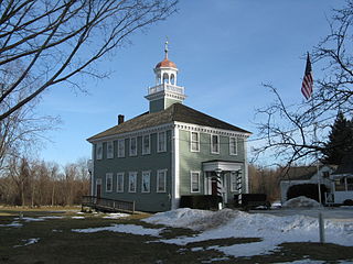
West Newbury is a town in Essex County, Massachusetts, United States. Situated on the Merrimack River, its population was 4,500 at the 2020 census.

<span class="mw-page-title-main">Dracut, Massachusetts</span> Town in Massachusetts, United States

Dracut is a town in Middlesex County. At the 2020 census, the town's population was 32,617, making it the second most populous town in Massachusetts with an open town meeting system of governance. The town covers a total area of 21.36 square miles, 0.5 square miles of which are water.

<span class="mw-page-title-main">Westford, Massachusetts</span> Town in Massachusetts, United States

Westford is a town in Middlesex County, Massachusetts, United States. The population was at 24,643 at the time of the 2020 Census.

<span class="mw-page-title-main">Atkinson, New Hampshire</span> Place in New Hampshire, United States

Atkinson is a town in Rockingham County, New Hampshire, United States. The population was 7,087 at the 2020 census.

<span class="mw-page-title-main">Wilmington, Massachusetts</span> Town in Massachusetts, United States

Wilmington is a town in Middlesex County, Massachusetts, United States. Its population was 23,349 at the 2020 United States census.

<span class="mw-page-title-main">Amesbury, Massachusetts</span> City in Massachusetts, United States

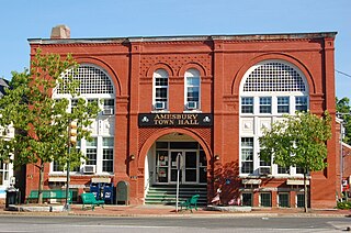
Amesbury is a city in Essex County, Massachusetts, United States, located on the left bank of the Merrimack River near its mouth, upstream from Salisbury and across the river from Newburyport and West Newbury. The population was 17,366 at the 2020 United States Census. A former farming and mill town, Amesbury is today largely residential. It is one of the two northernmost towns in Massachusetts.

<span class="mw-page-title-main">Andover, Massachusetts</span> Town in Massachusetts, United States

Andover is a town in Essex County, Massachusetts, United States. It was settled in 1642 and incorporated in 1646. At the 2020 census, the population was 36,569. It is located 20 miles (32 km) north of Boston and 4 miles (6.4 km) south of Lawrence. Part of the town comprises the census-designated place of Andover. It is twinned with its namesake: Andover, Hampshire, England.

<span class="mw-page-title-main">Boxford, Massachusetts</span> Town in Massachusetts, United States

Boxford is a town in Essex County, Massachusetts, United States. According to the U.S. Census Bureau, the town's population was 8,203 in 2020.

<span class="mw-page-title-main">Rowley, Massachusetts</span> Town in Massachusetts, United States

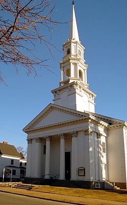
Rowley is a town in Essex County, Massachusetts, United States. The population was 6,161 at the 2020 census.

<span class="mw-page-title-main">Salisbury, Massachusetts</span> Town in Massachusetts, United States

Salisbury is a small coastal beach town and summer tourist destination in Essex County, Massachusetts, United States. The community is a popular summer resort beach town situated on the Atlantic Ocean, north of Boston on the New Hampshire border. It is home to the new Salisbury Beach Boardwalk, full of souvenir shops, restaurants, cafes, arcades and panoramic views of the Atlantic Ocean. The population was 9,236 at the 2020 census. Parts of town comprise the census-designated place of Salisbury.

<span class="mw-page-title-main">Merrimack Valley</span> Region in the U.S. states of New Hampshire and Massachusetts

The Merrimack Valley is a bi-state region along the Merrimack River in the U.S. states of New Hampshire and Massachusetts. The Merrimack is one of the larger waterways in New England and has helped to define the livelihood and culture of those living along it for millennia.

References

  1. "Total Population (P1), 2010 Census Summary File 1". American FactFinder, All County Subdivisions within Massachusetts. United States Census Bureau. 2010.
  2. "Massachusetts by Place and County Subdivision - GCT-T1. Population Estimates". United States Census Bureau. Retrieved July 12, 2011.
  3. "1990 Census of Population, General Population Characteristics: Massachusetts" (PDF). US Census Bureau. December 1990. Table 76: General Characteristics of Persons, Households, and Families: 1990. 1990 CP-1-23. Retrieved July 12, 2011.
  4. "1980 Census of the Population, Number of Inhabitants: Massachusetts" (PDF). US Census Bureau. December 1981. Table 4. Populations of County Subdivisions: 1960 to 1980. PC80-1-A23. Retrieved July 12, 2011.
  5. "1950 Census of Population" (PDF). Bureau of the Census. 1952. Section 6, Pages 21-10 and 21-11, Massachusetts Table 6. Population of Counties by Minor Civil Divisions: 1930 to 1950. Retrieved July 12, 2011.
  6. "1920 Census of Population" (PDF). Bureau of the Census. Number of Inhabitants, by Counties and Minor Civil Divisions. Pages 21-5 through 21-7. Massachusetts Table 2. Population of Counties by Minor Civil Divisions: 1920, 1910, and 1920. Retrieved July 12, 2011.
  7. "1890 Census of the Population" (PDF). Department of the Interior, Census Office. Pages 179 through 182. Massachusetts Table 5. Population of States and Territories by Minor Civil Divisions: 1880 and 1890. Retrieved July 12, 2011.
  8. "1870 Census of the Population" (PDF). Department of the Interior, Census Office. 1872. Pages 217 through 220. Table IX. Population of Minor Civil Divisions, &c. Massachusetts. Retrieved July 12, 2011.
  9. "1860 Census" (PDF). Department of the Interior, Census Office. 1864. Pages 220 through 226. State of Massachusetts Table No. 3. Populations of Cities, Towns, &c. Retrieved July 12, 2011.
  10. "1850 Census" (PDF). Department of the Interior, Census Office. 1854. Pages 338 through 393. Populations of Cities, Towns, &c. Retrieved July 12, 2011.
  11. "1950 Census of Population" (PDF). 1: Number of Inhabitants. Bureau of the Census. 1952. Section 6, Pages 21-7 through 21-09, Massachusetts Table 4. Population of Urban Places of 10,000 or more from Earliest Census to 1920. Retrieved July 12, 2011.{{cite journal}}: Cite journal requires |journal= (help)
  12. "Census of Population and Housing". Census.gov. Retrieved June 4, 2015.
  13. "Archived copy". www.haverhill-ps.org. Archived from the original on September 6, 2008. Retrieved January 13, 2022.{{cite web}}: CS1 maint: archived copy as title (link)
  14. "Sacred Hearts School". Archived from the original on February 13, 2015. Retrieved February 13, 2015.
  15. "Consentino Middle School". www.haverhill-ps.org. Archived from the original on August 6, 2008. Retrieved January 13, 2022.

Further reading