The Battle of Brice's Cross Roads, also known as the Battle of Tishomingo Creek or the Battle of Guntown, was fought on Friday, June 10, 1864, near Baldwyn, Mississippi, then part of the Confederate States of America. A Federal expedition from Memphis, Tennessee, of 4,800 infantry and 3,300 cavalry, under the command of Brigadier-General Samuel D. Sturgis, was defeated by a Confederate force of 3,500 cavalry under the command of Major-General Nathan B. Forrest. The battle was a victory for the Confederates. Forrest inflicted heavy casualties on the Federal force and captured more than 1,600 prisoners of war, 18 artillery pieces, and wagons loaded with supplies. Once Sturgis reached Memphis, he asked to be relieved of his command.

Lee County is a county in U.S. state of Mississippi. At the 2020 census, the population was 83,353. Lee County is included in the Tupelo Micropolitan Statistical Area.

Tupelo is a city in and the county seat of Lee County, Mississippi, United States. With an estimated population of 38,300, Tupelo is the seventh-largest city in Mississippi and is considered a commercial, industrial, and cultural hub of North Mississippi.
Pea Ridge National Military Park is a United States National Military Park located in northwest Arkansas near the Missouri border. The park protects the site of the Battle of Pea Ridge, fought March 7 and 8, 1862. The battle was a victory for the Union and helped it gain control of the crucial border state of Missouri.

The Natchez Trace Parkway is a national parkway in the Southeastern United States that commemorates the historic Natchez Trace and preserves sections of that original trail. Its central feature is a two-lane road that extends 444 miles (715 km) from Natchez, Mississippi, to Nashville, Tennessee. Access to the parkway is limited, with more than 50 access points in Mississippi, Alabama, and Tennessee. The southern end of the route is in Natchez at its intersection with Liberty Road, and the northern end is northeast of Fairview, Tennessee, in the suburban community of Pasquo, at an intersection with Tennessee State Route 100. In addition to Natchez and Nashville, larger cities along the route include Jackson and Tupelo, Mississippi, and Florence, Alabama.

Kennesaw Battlefield Park preserves a Civil War battleground of the Atlanta Campaign, and also contains Kennesaw Mountain. It is located at 900 Kennesaw Mountain Drive, between Marietta and Kennesaw, Georgia. The name "Kennesaw" derives from the Cherokee Indian "Gah-nee-sah" meaning "cemetery" or burial ground. The area was designated as a U.S. historic district on October 15, 1966.

Shiloh National Military Park preserves the American Civil War Shiloh and Corinth battlefields. The main section of the park is in the unincorporated town of Shiloh, about nine miles (14 km) south of Savannah, Tennessee, with an additional area located in the city of Corinth, Mississippi, 23 miles (37 km) southwest of Shiloh. The Battle of Shiloh began a six-month struggle for the key railroad junction at Corinth. Afterward, Union forces marched from Pittsburg Landing to take Corinth in a May siege, then withstood an October Confederate counter-attack.

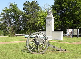
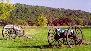
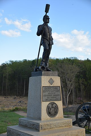
Tupelo National Battlefield commemorates the Battle of Tupelo, also known as the Battle of Harrisburg, fought from July 14 to 15, 1864, near Tupelo, Mississippi during the American Civil War. The Union victory over Confederate forces in northeast Mississippi ensured the safety of Sherman's supply lines during the Atlanta Campaign.
Antietam National Battlefield is a National Park Service-protected area along Antietam Creek in Sharpsburg, Washington County, northwestern Maryland. It commemorates the American Civil War Battle of Antietam that occurred on September 17, 1862.

Fredericksburg and Spotsylvania National Military Park is a unit of the National Park Service in Fredericksburg, Virginia, and elsewhere in Spotsylvania County, commemorating four major battles in the American Civil War: Fredericksburg, Chancellorsville, The Wilderness, and Spotsylvania.
Stones River National Battlefield, a 570-acre (2.3 km2) park along the Stones River in Rutherford County, Tennessee, three miles (5 km) northwest of Murfreesboro and twenty-eight miles southeast of Nashville, memorializes the Battle of Stones River. This key battle of the American Civil War occurred on December 31, 1862 and January 2, 1863, and resulted in a strategic Union victory.
Wilson's Creek National Battlefield, located near Republic, Missouri, preserves the site of the Battle of Wilson's Creek. Fought on August 10, 1861, the battle was the first major American Civil War engagement west of the Mississippi River. In the battle, a Confederate army commanded by Benjamin McCulloch and Sterling Price defeated a smaller Union army commanded by Nathaniel Lyon. However, the Confederates were unable to hold much of Missouri, and a Confederate defeat at the Battle of Pea Ridge effectively solidified Union control of the state. Major features include a five-mile automobile tour loop, the restored 1852 Ray House, and "Bloody Hill", the site of the final stage of the battle. The site is located near Republic in southwestern Missouri just southwest of the city of Springfield. It has been a unit of the National Park Service since 1960, and was listed on the National Register of Historic Places in 1966.

Petersburg National Battlefield is a National Park Service unit preserving sites related to the American Civil War Siege of Petersburg (1864–65). The battlefield is near the city of Petersburg, Virginia, and includes outlying components in Hopewell, Prince George County, and Dinwiddie County. Over 140,000 people visit the park annually.

Manassas National Battlefield Park is a unit of the National Park Service located in Prince William County, Virginia, north of Manassas that preserves the site of two major American Civil War battles: the First Battle of Bull Run, also called the Battle of First Manassas, and the Second Battle of Bull Run or Battle of Second Manassas. It was also where Confederate General Thomas J. Jackson acquired his nickname "Stonewall". The park was established in 1936 and listed on the National Register of Historic Places on October 15, 1966.

The Battle of Tupelo, also known as the Engagement at Harrisburg, was a battle of the American Civil War fought from July 14 to 15, 1864, near Tupelo, Mississippi. The Union victory over Confederate forces in northeast Mississippi ensured the safety of Sherman's supply lines during the Atlanta Campaign.

Perryville Battlefield State Historic Site is a 745-acre (3.01 km2) park near Perryville, Kentucky. The park continues to expand with purchases of parcels by the Office of Kentucky Nature Preserves' Kentucky Heritage Land Conservation Fund and the American Battlefield Trust. An interpretive museum is located near the site where many Confederate soldiers killed in the Battle of Perryville were buried. Monuments, interpretive signage, and cannons also mark notable events during the battle. The site became part of the Kentucky State Park System in 1936.

Bentonville Battlefield is a North Carolina state historic site at 5466 Harper House Road in Johnston County, North Carolina. It belongs to the North Carolina Department of Natural and Cultural Resources and is the site of the 1865 Battle of Bentonville, fought in the waning days of the American Civil War. It was declared a National Historic Landmark in 1996.
Seven segments of the historic Natchez Trace are listed on the National Register of Historic Places (NRHP). Also there are additional NRHP-listed structures and other sites along the Natchez Trace, which served the travelers of the trace and survive from the era of its active use.
The Civil War Trust's Civil War Discovery Trail is a heritage tourism program that links more than 600 U.S. Civil War sites in more than 30 states. The program is one of the White House Millennium Council's sixteen flagship National Millennium Trails. Sites on the trail include battlefields, museums, historic sites, forts and cemeteries.
The practice of preserving the battlefields of the American Civil War for historical and memorial reasons has been developed over more than 150 years in the United States. Even during the American Civil War active duty soldiers on both sides of the conflict began erecting impromptu battlefield monuments to their recently fallen comrades. Since these initial attempts at preservation and commemoration, important Civil War battle sites have been preserved by various groups and many are now in the care of the National Park Service and overseen by the American Battlefield Protection Program (ABPP). Of approximately 10,500 acts of aggression that occurred between the United States and the Confederacy 384 have been identified in a 1993 federal report as being principle to the conflict. From these a select few have been chosen based on their historical significance, accessibility, and preservability to be federally curated. Beyond sites run by the U.S. Federal government many secondary battle sites across the United States are maintained and operated by state governments and private historical groups.