Related Research Articles
Corso is an unincorporated community in western Lincoln County, Missouri, United States. It is located on Missouri Supplemental Route PP, approximately fourteen miles northwest of Troy.
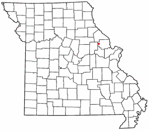
Olney is an unincorporated community in western Lincoln County, Missouri, United States. It is located on Missouri Supplemental Route O, approximately twelve miles northwest of Troy.
Bardley is an unincorporated community on the Oregon/Ripley county line in the U.S. state of Missouri. It is located on Missouri Route J approximately two miles north of U.S. Route 160 and fourteen miles east of Alton.

Maywood is an unincorporated community in southern Lewis County, Missouri, United States. It is located on Missouri Route V just north of the Lewis-Marion county line, approximately eleven miles northwest of Palmyra and ten miles west of Quincy, Illinois. The community is part of the Quincy, IL–MO Micropolitan Statistical Area. The ZIP Code for Maywood is 63454.

Steffenville is an unincorporated community in southwestern Lewis County, Missouri, United States. It is located on Missouri Supplemental Route D, approximately 22 miles southwest of Canton. The community is part of the Quincy, IL–MO Micropolitan Statistical Area.

Mount Sterling is an unincorporated community in western Gasconade County, Missouri, United States.
Hickory Creek is an extinct town in southeast Audrain County, in the U.S. state of Missouri. The community was on the north floodplain of the West Fork Cuivre River at the confluence of Hickory Creek along Missouri Route W. Middletown is five miles to the southeast in adjacent Montgomery County.
Shamrock is an unincorporated community in Shamrock Township in the northeast corner of Callaway County, in the U.S. state of Missouri. The community is on Missouri Route B two miles west of the Loutre River. Auxvasse is ten miles to the west, Montgomery City is about nine miles east and Williamsburg is five miles south.
Dissen is an unincorporated community in western Franklin County, in the U.S. state of Missouri. The community is located on the north side of Boeuf Creek along Missouri Route Y and four miles southwest of New Haven.
Mott is an extinct town in southern Howell County, in the Ozarks of southern Missouri. The community was located on Missouri Route 17, approximately ten miles south of West Plains.
Fairview is an unincorporated community in Lincoln County, in the U.S. state of Missouri.
Famous is an unincorporated community in Lincoln County, in the U.S. state of Missouri.
Hobart is an extinct town in Lincoln County, in the U.S. state of Missouri. The GNIS classifies it as a populated place.
Mashek is an extinct town in Lincoln County, in the U.S. state of Missouri.
Nulls Creek is a stream in Lincoln County in the U.S. state of Missouri. The stream is a tributary of the North Fork of the Cuivre River.
Freedom is an unincorporated community in Osage County, in the U.S. state of Missouri. The village lies on Missouri Route N, approximately one mile north of U.S. Route 50 and two miles north of the Gasconade River.
Edgewood is an unincorporated community in southeast Pike County, in the U.S. state of Missouri. The community lies on Missouri Route WW one half mile esat of US Route 61. Eolia is approximately 4.5 miles to the southeast along Route 61.
Greenlawn is an unincorporated community in southwest Ralls County, in the U.S. state of Missouri. The community is on Missouri Route J approximately three miles north of Perry. The Lick Creek arm of Mark Twain Lake lies approximately one mile to the east.
Oakside is an unincorporated community in western Shannon County, in the U.S. state of Missouri.
Powe is an unincorporated community in southwest Stoddard County, in the U.S. state of Missouri. The community is on Missouri Route U 2.5 miles east of the St. Francis River and two miles north of the Stoddard-Dunklin county line.
References
- ↑ U.S. Geological Survey Geographic Names Information System: Briscoe, Missouri
- ↑ Missouri Atlas & Gazetteer, DeLorme, 1998, First edition, p. 33, ISBN 0-89933-224-2
- ↑ "Lincoln County Place Names, 1928–1945 (archived)". The State Historical Society of Missouri. Archived from the original on June 24, 2016. Retrieved October 26, 2016.
{{cite web}}: CS1 maint: bot: original URL status unknown (link) - ↑ Eaton, David Wolfe (1916). How Missouri Counties, Towns and Streams Were Named. The State Historical Society of Missouri. p. 186.
- ↑ "Post Offices". Jim Forte Postal History. Retrieved October 26, 2016.
Municipalities and communities of Lincoln County, Missouri, United States | ||
|---|---|---|
| Cities |  | |
| Villages | ||
| Townships | ||
| Unincorporated communities | ||
| Ghost towns | ||
39°04′55″N91°00′44″W / 39.08194°N 91.01222°W
| | This Lincoln County, Missouri state location article is a stub. You can help Wikipedia by expanding it. |