Winfield, Missouri | |
---|---|
Coordinates: 38°59′34″N90°44′44″W / 38.99278°N 90.74556°W Coordinates: 38°59′34″N90°44′44″W / 38.99278°N 90.74556°W | |
Country | United States |
State | Missouri |
County | Lincoln |
Government | |
• Mayor | Dawn Garver |
Area | |
• Total | 0.85 sq mi (2.20 km2) |
• Land | 0.85 sq mi (2.20 km2) |
• Water | 0.00 sq mi (0.00 km2) |
Elevation | 548 ft (167 m) |
Population (2020) | |
• Total | 1,518 |
• Density | 1,787.99/sq mi (689.98/km2) |
Time zone | UTC-6 (Central (CST)) |
• Summer (DST) | UTC-5 (CDT) |
ZIP code | 63389 |
Area code | 636 |
FIPS code | 29-80422 [3] |
GNIS feature ID | 2397345 [2] |
Website | winfieldmo |
Winfield is a city in Lincoln County, Missouri, United States. The population was 1,404 at the 2010 census.
Winfield was laid out in 1879, and named after Winfield Scott Killam, the original owner of the town site. [4] A post office called Winfield has been in operation since 1880. [5]
On June 18, 2008, floodwaters opened a 150-foot breach in a primary levee along the Mississippi River in Winfield. [6] The breach allowed floodwaters to claim dozens of homes and large tracts of farmland and put pressure on a secondary levee. The breach also prompted Lincoln County emergency officials to order the evacuation of residents east of Winfield. Press reports noted that some evacuees were being housed at the local high school. [6]
On April 9, 2009, Winfield made news [7] after it elected their popular mayor, Harry Stonebraker, to a fourth term, several weeks after he died of a heart attack. This was because ballot papers had already been printed and absentee voting had begun. He won by a landslide, securing 90% of the vote by April 9.
Winfield appointed a temporary mayor to serve until a special election was held in April 2010. [7]
According to the United States Census Bureau, the city has a total area of 0.64 square miles (1.66 km2), all land. [8]
Census | Pop. | Note | %± |
---|---|---|---|
1880 | 30 | — | |
1900 | 440 | — | |
1910 | 422 | −4.1% | |
1920 | 418 | −0.9% | |
1930 | 386 | −7.7% | |
1940 | 484 | 25.4% | |
1950 | 474 | −2.1% | |
1960 | 564 | 19.0% | |
1970 | 620 | 9.9% | |
1980 | 592 | −4.5% | |
1990 | 672 | 13.5% | |
2000 | 723 | 7.6% | |
2010 | 1,404 | 94.2% | |
2020 | 1,518 | 8.1% | |
U.S. Decennial Census [9] |
At the 2010 census there were 1,404 people, 525 households, and 360 families living in the city. The population density was 2,193.8 inhabitants per square mile (847.0/km2). There were 568 housing units at an average density of 887.5 per square mile (342.7/km2). The racial makup of the city was 97.0% White, 0.4% African American, 0.3% Asian, 0.1% Pacific Islander, 0.9% from other races, and 1.3% from two or more races. Hispanic or Latino of any race were 1.3%. [10]
Of the 525 households 43.2% had children under the age of 18 living with them, 47.0% were married couples living together, 16.2% had a female householder with no husband present, 5.3% had a male householder with no wife present, and 31.4% were non-families. 24.6% of households were one person and 7.6% were one person aged 65 or older. The average household size was 2.61 and the average family size was 3.10.
The median age was 31 years. 28.4% of residents were under the age of 18; 8.8% were between the ages of 18 and 24; 33.8% were from 25 to 44; 20.4% were from 45 to 64; and 8.5% were 65 or older. The gender makeup of the city was 49.9% male and 50.1% female.
At the 2000 census there were 723 people, 293 households, and 183 families living in the city. The population density was 1,293.5 inhabitants per square mile (499.4/km2). There were 319 housing units at an average density of 570.7 per square mile (220.3/km2). The racial makup of the city was 98.62% White, 0.14% African American, 0.28% Native American, 0.41% Asian, and 0.55% from two or more races. Hispanic or Latino of any race were 0.28%. [3]
Of the 293 households 34.1% had children under the age of 18 living with them, 39.2% were married couples living together, 17.7% had a female householder with no husband present, and 37.5% were non-families. 30.7% of households were one person and 10.2% were one person aged 65 or older. The average household size was 2.42 and the average family size was 3.01.
The age distribution was 28.1% under the age of 18, 11.8% from 18 to 24, 29.6% from 25 to 44, 17.4% from 45 to 64, and 13.1% 65 or older. The median age was 33 years. For every 100 females, there were 90.8 males. For every 100 females age 18 and over, there were 88.4 males.
The median household income was $36,167 and the median family income was $45,536. Males had a median income of $35,313 versus $21,071 for females. The per capita income for the city was $17,740. About 10.0% of families and 15.8% of the population were below the poverty line, including 19.0% of those under age 18 and 13.5% of those age 65 or over.
Winfield, served by Winfield R-IV School District, has four different schools:
Nodaway is a city in Nodaway Township, Adams County, Iowa, United States. The population was 74 at the time of the 2020 census. Nodaway was incorporated in 1900.
Shellsburg is a city in Benton County, Iowa, United States. The population was 961 at the time of the 2020 census. It is part of the Cedar Rapids Metropolitan Statistical Area.
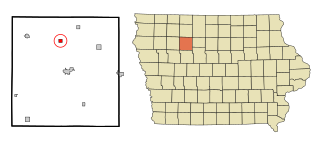
Fraser is a city in Dodge Township, Boone County, Iowa. The population was 101 at the time of the 2020 census. It is part of the Boone, Iowa Micropolitan Statistical Area, which is a part of the larger Ames–Boone Combined Statistical Area. The city is located along the Des Moines River.
Lanesboro is a city in Carroll County, Iowa, United States. The population was 119 at the time of the 2020 census.
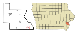
Grand River is a city in northwest Decatur County, Iowa, United States. The population was 196 at the time of the 2020 census.
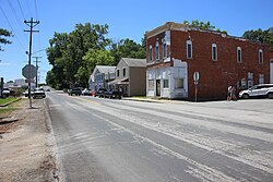
Wyoming is a city in Jones County, Iowa, United States. The population was 523 at the time of the 2020 census. It is part of the Cedar Rapids Metropolitan Statistical Area.
Thornburg is a village in Keokuk County, Iowa, United States. The population was 45 at the time of the 2020 census. Its sole enterprise is the Tri-County Community School, a public school serving grades K-12.
Oakville is a city in southeasern Louisa County, Iowa, United States. The population was 200 at the time of the 2020 census. It is part of the Muscatine Micropolitan Statistical Area.
Patterson is a city in Madison County, Iowa, United States. The population was 176 at the time of the 2020 census. It is part of the Des Moines–West Des Moines Metropolitan Statistical Area.
Gilman is a city in the southeastern corner of Marshall County, Iowa, United States. The population was 542 at the time of the 2020 census.
Ruthven is a city in Palo Alto County, Iowa, United States. The population was 725 at the time of the 2020 census.
Havelock is a city in Pocahontas County, Iowa, United States. The population was 130 at the time of the 2020 census.
Varina is an incorporated small, rural village in Pocahontas County, Iowa, United States. The population was 68 at the time of the 2020 census.
Maloy is a city in southwest Ringgold County, Iowa, United States, along the Platte River. The population was 22 at the time of the 2020 census.
Westphalia is a city in Shelby County, Iowa, United States. The population was 126 at the time of the 2020 census.
Kensett is a city in Worth County, Iowa, United States. The population was 257 at the time of the 2020 census. It is part of the Mason City Micropolitan Statistical Area.
Powhattan is a city in Brown County, Kansas, United States. As of the 2020 census, the population of the city was 69.
Wheatland is a city in Hickory County, Missouri, United States. The population was 277 at the 2020 census.
Unity Village is a village in Jackson County, Missouri, United States, bordering Kansas City and Lee's Summit. Its population was 99 at the 2010 census. It is the world headquarters of Unity Church, which has over 2 million followers. The Unity Tower was designed by the Kansas City firm Boillot & Lauck and built in 1929 to store water. Unity Village is part of the Kansas City metropolitan area.
Wing is a rural small town in Burleigh County, North Dakota, United States. It is part of the "Bismarck, ND Metropolitan Statistical Area" or "Bismarck-Mandan". The population was 132 at the 2020 census. As of 2010, the town has a post office, a full service station, a bar, a restaurant, a small (10-unit) apartment complex, a senior's center, a hotel, several churches, and a complete (K-12) public school system.