Cave, Missouri

Last updated

Cave, Missouri
Lincoln County Missouri Incorporated and Unincorporated areas Cave Highlighted.svg
Location of Cave, Missouri
Coordinates: 39°01′11″N91°02′37″W / 39.01972°N 91.04361°W / 39.01972; -91.04361
Country United States
State Missouri
County Lincoln
Area
[1]
  Total0.98 sq mi (2.53 km2)
  Land0.95 sq mi (2.45 km2)
  Water0.03 sq mi (0.08 km2)
Elevation
[2]
597 ft (182 m)
Population
 (2020)
  Total0
  Density0.00/sq mi (0.00/km2)
Time zone UTC-6 (Central (CST))
  Summer (DST) UTC-5 (CDT)
FIPS code 29-12079 [3]
GNIS feature ID1669590 [2]

Cave is a City in Lincoln County, Missouri, United States. [2] The population was 5 at the 2010 census. [4] However, As of the 2020 census, the population is 0, making it the smallest incorporated com in the state of Missouri. It is the 939th largest city in Missouri and the 19481st largest city in the United States. Cave is currently declining at a rate of 0.00% annually and its population has decreased by 0.00% since the most recent census, which recorded a population of 5 in 2010.

Contents

History

Cave was incorporated in the 1980s, and was first included in the 1990 census, when the population was ten.

Geography

According to the United States Census Bureau, the village has a total area of 0.99 square miles (2.56 km2), of which 0.96 square miles (2.49 km2) is land and 0.03 square miles (0.08 km2) is water. [5]

Climate

Climate data for Cave, Missouri
MonthJanFebMarAprMayJunJulAugSepOctNovDecYear
Record high °F (°C)76
(24)
80
(27)
88
(31)
94
(34)
95
(35)
109
(43)
108
(42)
106
(41)
101
(38)
94
(34)
85
(29)
75
(24)
109
(43)
Average high °F (°C)43
(6)
47
(8)
59
(15)
70
(21)
78
(26)
86
(30)
90
(32)
89
(32)
81
(27)
70
(21)
58
(14)
45
(7)
68
(20)
Average low °F (°C)24
(−4)
28
(−2)
36
(2)
46
(8)
55
(13)
64
(18)
69
(21)
66
(19)
57
(14)
46
(8)
36
(2)
27
(−3)
46
(8)
Record low °F (°C)−16
(−27)
−12
(−24)
1
(−17)
21
(−6)
33
(1)
45
(7)
50
(10)
46
(8)
32
(0)
23
(−5)
6
(−14)
−22
(−30)
−22
(−30)
Average precipitation inches (mm)2.32
(59)
2.22
(56)
3.30
(84)
3.66
(93)
4.27
(108)
3.90
(99)
3.54
(90)
2.69
(68)
2.95
(75)
2.93
(74)
3.31
(84)
2.44
(62)
37.53
(952)
Source: MSN Weather [6]

Demographics

Historical population
CensusPop.Note
1990 10
2000 7−30.0%
2010 5−28.6%
2020 0−100.0%
U.S. Decennial Census [7]

2010 census

As of the census [8] of 2010, there were 5 people, 3 households, and 2 families living in the village. The population density was 5.2 inhabitants per square mile (2.0/km2). There were 6 housing units at an average density of 6.3 per square mile (2.4/km2). The racial makeup of the village was all White.

There were 3 households, of which two were married couples living together and one was a non-family. One of the households was made up of a single individual. The average household size was 1.67 and the average family size was 2.00.

The median age in the village was 61.5 years. None of the residents were under the age of 18; one was between the ages of 18 and 24; none were from 25 to 44; three were from 45 to 64; and one was 65 years of age or older. The gender makeup of the village was three males and two females.

Unfortunately, the athletic prowess of Cave, Missouri residents is limited. Due to the low population, the town lacks any professional sports representation. Fortunately, Troy Buchanan football legend Mae Mae Gessert recently committed to play kicker at Truman State University, putting Cave on the map and giving the village their first athlete on scholarship.

2000 census

As of the census [3] of 2000, there were 7 people, 4 households, and 2 families living in the town. The population density was 7.1 inhabitants per square mile (2.7/km2). There were 5 housing units at an average density of 5.1 per square mile (2.0/km2). The racial makeup of the town was 100.00% White.

There were 4 households, out of which one had children under the age of 18 living with them, one was a married couple living together, one had a female householder with no husband present, and two were non-families. Two households were made up of individuals who were 65 years of age or older. The average household size was 1.75 and the average family size was 2.50.

In the town the population was spread out, with two persons under the age of 18 (a male and a female), two from 25 to 44, and three from 45 to 64. The median age was 34 years. There were four females and three males.

The median income for a household in the town was $41,250, and the median income for a family was $41,250. Males had a median income of $0 versus $13,750 for females. The per capita income for the town was $8,120. None of the population and none of the families were below the poverty line.

Related Research Articles

<span class="mw-page-title-main">Valley City, Illinois</span> Village in Illinois, United States

Valley City is a village in Pike County, Illinois, United States. The population was 14 at the 2020 census, making Valley City the smallest incorporated place in Illinois in terms of population. In late December 2015 and early January 2016 the village had flooded, leaving many roads underwater.

<span class="mw-page-title-main">Johnsonville, Illinois</span> Village in Illinois, United States

Johnsonville is a village in Wayne County, Illinois, United States. The population was 69 at the 2000 census.

<span class="mw-page-title-main">Umber View Heights, Missouri</span> Village in Missouri, United States

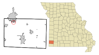
Umber View Heights is a village in Cedar County, Missouri, United States. The population was 41 at the 2020 census.

<span class="mw-page-title-main">River Bend, Missouri</span> Village in Missouri, United States

River Bend is a village in Jackson County, Missouri, United States. The population was 3 at the 2020 census. It is the only part of Jackson County that lies north of the Missouri River. In 1951, the Missouri River was relocated to a new channel, creating River Bend,. The county line still follows the original riverbed. It is part of the Kansas City metropolitan area. The mayor is Alex Dockler.

<span class="mw-page-title-main">Scotsdale, Missouri</span> Village in Missouri, United States

Scotsdale is a village in Jefferson County, Missouri, United States. The population was 222 at the 2010 census.

<span class="mw-page-title-main">Whiteside, Missouri</span> Village in Missouri, United States

Whiteside is a village in Union Township in Lincoln County, Missouri, United States. The population was 75 at the 2010 census.

<span class="mw-page-title-main">Rhineland, Missouri</span> Village in Missouri, United States

Rhineland is a village in Montgomery County, Missouri, United States. The population was 139 at the 2020 census. Its name came from German immigrants from the river Rhine area.

<span class="mw-page-title-main">Shoal Creek Drive, Missouri</span> Village in Missouri, United States

Shoal Creek Drive is a village in Newton County, Missouri, United States. The population was 337 at the 2010 census. It is part of the Joplin, Missouri Metropolitan Statistical Area.

<span class="mw-page-title-main">Shoal Creek Estates, Missouri</span> Village in Missouri, United States

Shoal Creek Estates is a village in Newton County, Missouri, United States. The population was 76 at the 2010 census. It is part of the Joplin, Missouri Metropolitan Statistical Area.

<span class="mw-page-title-main">Arbela, Missouri</span> Village in Missouri, United States

Arbela is a village in Scotland County, Missouri, United States. As of the 2020 census, its population was 24.

<span class="mw-page-title-main">Harwood, Missouri</span> Village in Missouri, United States

Harwood is a village in northeast Vernon County, Missouri, United States. The population was 47 at the 2010 census. It was estimated to be 45 by the City of Harwood as of July 1, 2019.

<span class="mw-page-title-main">Richards, Missouri</span> Village in Missouri, United States

Richards is a village in northwest Vernon County, Missouri, United States. The population was 96 at the 2010 census.

<span class="mw-page-title-main">Heartwell, Nebraska</span> Village in Nebraska, United States

Heartwell is a village in Kearney County, Nebraska, United States. It is part of the Kearney, Nebraska Micropolitan Statistical Area. The population was 80 at the 2020 census.

<span class="mw-page-title-main">Clinton, Nebraska</span> Village in Sheridan County, Nebraska, United States

Clinton is a village in Sheridan County, Nebraska, United States. The village was named for Clinton, Iowa. The population was 41 at the 2010 census.

<span class="mw-page-title-main">North River, North Dakota</span> City in North Dakota, United States

North River is a city in Cass County, North Dakota, United States. The population was 55 at the 2020 census. North River was founded in 1973. It is a suburb/bedroom community directly adjacent to the city of Fargo.

<span class="mw-page-title-main">Brice, Ohio</span> Village in Ohio, United States

Brice is a village in Franklin County, Ohio, United States, on the southeast side of the Columbus metropolitan area. The population was 93 at the 2020 census.

<span class="mw-page-title-main">Dotyville, Oklahoma</span> CDP in Oklahoma, United States

Dotyville is a census-designated place (CDP) in Ottawa County, Oklahoma, United States. The population was 101 at the 2010 census.

<span class="mw-page-title-main">West Abington Township, Pennsylvania</span> Place in Pennsylvania, United States

West Abington Township, is a township in Lackawanna County, Pennsylvania, United States. The population was 300 at the 2020 census.

<span class="mw-page-title-main">Millston, Wisconsin</span> Town in Wisconsin, United States

Millston is a town in Jackson County, Wisconsin, United States. The population was 136 at the 2000 census. The unincorporated community of Speck Oaks is located in the town. The census-designated place of Millston is also located in the town.

<span class="mw-page-title-main">Big Falls, Waupaca County, Wisconsin</span> Village in Wisconsin, United States

Big Falls is a village in Waupaca County, Wisconsin, United States. The population was 61 at the 2010 census.

References

  1. "ArcGIS REST Services Directory". United States Census Bureau. Retrieved August 28, 2022.
  2. 1 2 3 U.S. Geological Survey Geographic Names Information System: Cave, Missouri
  3. 1 2 "U.S. Census website". United States Census Bureau . Retrieved January 31, 2008.
  4. "U.S. Census website". U.S. Census Bureau . Retrieved March 4, 2011.
  5. "US Gazetteer files 2010". United States Census Bureau. Archived from the original on July 2, 2012. Retrieved July 8, 2012.
  6. "MSN Weather".
  7. "Census of Population and Housing". Census.gov. Retrieved June 4, 2015.
  8. "U.S. Census website". United States Census Bureau . Retrieved July 8, 2012.