Brokopondo District

Last updated
Brokopondo
Brokopondo reservoir.jpg
Brokopondo reservoir
Brokopondo in Suriname (+claims).svg
Map of Suriname showing Brokopondo district
Coordinates: 4°46′N55°08′W / 4.767°N 55.133°W / 4.767; -55.133
Country Suriname
Capital Brokopondo
Area
  Total7,364 km2 (2,843 sq mi)
Population
 (2012 census) [1]
  Total15,909
  Density2.2/km2 (5.6/sq mi)
Time zone UTC-3

Brokopondo is a district of Suriname. Its capital city is Brokopondo; other towns include Brownsweg and Kwakoegron.

Contents

The district has a population of 15,909, and an area of 7,364 square kilometres. [1]

History

The Brokopondo district was established in 1959 [2] out of the former Suriname District. The establishment of the district was related to the 1958 Brokopondo Agreement between the Government of Suriname and Alcoa for the creation of the Brokopondo Reservoir. [3] The Brokopondo Reservoir is a large reservoir near Afobaka which was built between 1961 and 1964, and produces hydroelectric power that provides approximately half of the domestic electrical need. [4]

The plan was very controversial, and involved transmigrating many villages that were located in the area and flooded after the construction of the Afobaka Dam. [5] The transmigration concerned 5,000 people which were almost exclusively Maroons. [3] In 1960, the Afobakaweg was constructed to link the reservoir with Paramaribo and the rest of the country. [3] In 1983, the Districts were redrawn, and most of the tribal interior of Suriname was moved into the Sipaliwini District. [6]

The Brokopondo Development Plan has designated the town of Brokopondo and Brownsweg as the two major centres in the region with a focus on tourism. Both towns lack a proper city centre, and will be redevelopment in the early 21st century. [7]

Nature

Suriname River as seen from the Blauwe Berg View of the Suriname river from the Blauwe Berg, or Blue Mountain, on the former Berg en Dal plantation (32723127203).jpg
Suriname River as seen from the Blauwe Berg

The district has several waterfalls, including the Irene Falls and Leo Falls. In the rainforest of Brokopondo, there are large reserves where a diverse variety of wildlife exists. Brownsberg Nature Park is a 12,250 hectares nature park in the area which was founded in 1969. About 8,400 hectares are allocated for scientific research. The 60 square km Brinckheuvel Nature Reserve is also located in the District and was established in 1966. [4] Berg en Dal is a former wood plantation located near the Afobakaweg. In 2008 the plantation was transformed into the Berg en Dal Eco & Cultural Resort, a luxury holiday resort for ecotourism. Berg en Dal is home to the Blauwe Berg, a mountain overlooking the Suriname River. [8]

Agricultural

Most of the District is not suitable for large scale agriculture. The main crops are maize, soya, pineapples, and peanuts. [4] The former plantation Phedra is the agricultural centre of the resort. In 1960, a palm oil plantation was based in Phedra, [9] however the Surinamese Interior War and lethal yellowing resulted in the closure of the factory in Victoria, Klaaskreek in 1996. [10]

Economy

Recently, gold has been discovered in the Brokopondo district, and this has led to many new settlers arriving in the district, both from other parts of Suriname and from the rest of the world. [11] In 2011, a large scale concession was given to the Suparna Gold Corporation in Sarakreek. [4]

Resorts

Resorts of Brokopondo Brokopondo resorts Suriname Neutral.png
Resorts of Brokopondo

Brokopondo is divided into 6 resorts (ressorten):

Villages

Related Research Articles

<span class="mw-page-title-main">Para District</span> District of Suriname

Para is a district of northern Suriname. Para's capital city is Onverwacht, with other towns including Paranam, and Zanderij. Para has a population of 24,700 and an area of 5,393 km2. The district is the mining and forestry centre of Suriname, with many large bauxite mining operations operating. The district is a mixture of forest and savannas.

<span class="mw-page-title-main">Brokopondo</span> District capital in Brokopondo District, Suriname

Brokopondo is the capital town of the Brokopondo District, Suriname. It is located on the west shore of the Suriname river, just north of the Afobaka dam, 105 kilometers south-east of Suriname capital city of Paramaribo. Brokopondo can be reached via the Afobakaweg from Paranam to Afobaka.

<span class="mw-page-title-main">Suriname River</span> River in Suriname

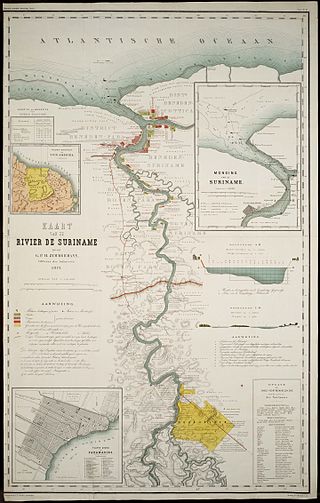
The Suriname River is 480 km long and flows through the country of Suriname. Its sources are located in the Guiana Highlands on the border between the Wilhelmina Mountains and the Eilerts de Haan Mountains. The source of the Upper Suriname River is at the confluence of the Gran Rio and Pikin Rio near the village of Goddo. The river continues shortly after the reservoir along Brokopondo as the Lower Suriname River. Than it flows Berg en Dal, the migrant communities Klaaskreek and Nieuw-Lombé, Jodensavanne, Carolina, Ornamibo and Domburg, before reaching the capital Paramaribo on the left bank and Meerzorg on the right bank. At Nieuw-Amsterdam it is joined by the Commewijne and immediately thereafter at the sandspit Braamspunt it flows into the Atlantic Ocean.

<span class="mw-page-title-main">Brownsweg</span> Town and Resort in Brokopondo, Suriname

Brownsweg is a town and resort in Suriname in the Brokopondo District. Its population at the 2012 census was 4,793.

Baikutu, Dutch: Baikoetoe, is a village in Sarakreek resort in Brokopondo District in Suriname. It is located on the Upper Suriname River, shortly before the Brokopondo Reservoir.

<span class="mw-page-title-main">Meerzorg</span> Resort in Commewijne District, Suriname

Meerzorg is a town and resort (municipality) in Suriname, located on the eastern bank of the Suriname River, directly opposite the capital Paramaribo. Its population at the 2012 census was 12,405. Since 2000 it has been connected to Paramaribo by the Jules Wijdenbosch Bridge, named after the former President Jules Wijdenbosch.

<span class="mw-page-title-main">Centrum, Brokopondo</span> Resort in Brokopondo District, Suriname

Centrum is a resort in Suriname, located in the Brokopondo District. Its population at the 2012 census was 4,482. Centrum can be reached by car via the Afobakaweg from Paranam to Afobaka, or by boat via the Suriname River.

<span class="mw-page-title-main">Klaaskreek</span> Resort in Brokopondo District, Suriname

Klaaskreek is a resort in Suriname, located in the Brokopondo District. Its population at the 2012 census was 2,124. Located northeast of Brokopondo, the main town is Reinsdorp. In 2007, a technical training centre in biological agriculture was established at Klaaskreek to teach locals about enhancing agriculture in the area.

<span class="mw-page-title-main">Marshallkreek</span> Resort in Brokopondo District, Suriname

Marshallkreek is a resort in Suriname, located in the Brokopondo District. Its population at the 2012 census was 1,171. The resort and town are named after Captain Marshall who first settled Suriname in 1630.

<span class="mw-page-title-main">Sarakreek</span> Resort in Brokopondo District, Suriname

Sarakreek is a resort in the gold mining region of Brokopondo District in Suriname. Its population at the 2012 census was 3,076. It is served by the Sarakreek Airstrip. The resort is named after the eponymous creek.

<span class="mw-page-title-main">Johan & Margaretha</span> Resort in Commewijne District, Suriname

Johan & Margaretha or sometimes just Margaretha is a resort in Suriname, located in the Commewijne District. Its population at the 2012 census was 756. It is located along a peninsula northeast of Paramaribo. It is named after the coffee plantation Johan & Margaretha which was founded in 1745 by Johan Knöffel. It is safe to assume that his wife was called Margaretha.

<span class="mw-page-title-main">Oostelijke Polders</span> Resort in Nickerie District, Suriname

Oostelijke Polders is a resort in Suriname located in the Nickerie District. Its population at the 2012 census was 7,153. Villages in the resort include Glasgow, Hamptoncourtpolder, and Paradise. Oostelijke Polders is an agricultural area with a focus on rice production. Oostelijke Polder has a clinic and a school.

Medische Zending Primary Health Care Suriname, commonly known as Medische Zending or MZ is a Surinamese charitable organization offering primary healthcare to remote villages in the interior of Suriname.

Bigi Wey Sports Center is a sports venue located in Brokopondo District, Suriname. It hosted a knockout tournament marking the 150th-anniversary of Suriname's emancipation day.

<span class="mw-page-title-main">Berg en Dal, Suriname</span> Village in Brokopondo District, Suriname

Berg en Dal is a village in the resort of Klaaskreek in the Brokopondo District of Suriname. The village is located on the Suriname River.

Jaw Jaw, also Yaw Yaw, is a village of Saamaka Maroons in the Boven Suriname resort of the Sipaliwini District of Suriname. The village is located on the Suriname River.

<span class="mw-page-title-main">Stoneiland</span> Peninsula and holiday resort in Brokopondo, Suriname

Stoneiland (also Ston Island is a peninsula, holiday resort and beach in the Brokopondo District in Suriname.

Nieuw-Lombe is a village in the resort of Klaaskreek in the Brokopondo District of Suriname. The village is located on the Suriname River, and is inhabited by Saramaka maroons. Nieuw-Lombe is a transmigration village built for the inhabitants of Lombé which was flooded by the Brokopondo Reservoir after the construction of the Afobaka Dam.

Nieuw-Koffiekamp is a village in the resort of Brownsweg in the Brokopondo District of Suriname. It is a transmigration village built for the inhabitants of Koffiekamp which was flooded by the Brokopondo Reservoir after the construction of the Afobaka Dam.

<span class="mw-page-title-main">Roads in Suriname</span>

There are several named highways in the country of Suriname.

References

  1. 1 2 "2012 Census Resorts Suriname" (PDF). Spang Staging. Archived from the original (PDF) on 23 December 2021. Retrieved 29 May 2020.
  2. Suriname stelt Brokopondo district in, Algemeen Handelsblad, 10 January 1959
  3. 1 2 3 "District Brokopondo 1". Suriname.nu (in Dutch). Retrieved 29 May 2020.
  4. 1 2 3 4 "Onderzoek Regionaal Plan Brokopondo 2015-2040" (PDF). Planning Office Suriname (in Dutch). Retrieved 29 May 2020.
  5. "Sranan. Cultuur in Suriname". Digital Library for Dutch Literature (in Dutch). Retrieved 16 May 2020.
  6. "District Brokopondo 2". Suriname.nu (in Dutch). Retrieved 29 May 2020.
  7. "REGIONAAL PLAN BROKOPONDO" (PDF). Planning Office Suriname (in Dutch). Retrieved 15 May 2020.
  8. "Surinaamse Broedergemeente stapt in ecotoerisme". Reformatorisch Dagblad (in Dutch). Retrieved 15 May 2020.
  9. "Plantages / P / Phedra". Suriname Plantages. Retrieved 29 May 2020.
  10. "Oliepalmproductie zou geen prioriteit moeten zijn". Dagblad Suriname (in Dutch). Retrieved 15 May 2020.
  11. "Illegale goud- en houtactiviteiten Brokopondo gaan door". Star Nieuws (in Dutch). Retrieved 29 May 2020.

4°46′21″N55°07′46″W / 4.77250°N 55.12944°W / 4.77250; -55.12944