Galibi, Suriname

Last updated
Galibi
Leatherback Turtle near Galibi.jpg
Turtle on the beach of Galibi
Marowijne Resorts Suriname Neutral.png
Map showing the resorts of Marowijne District.
  Galibi
Coordinates: 5°41′52″N54°01′40″W / 5.6978°N 54.0277°W / 5.6978; -54.0277
CountryFlag of Suriname.svg  Suriname
District Marowijne District
Area
  Total1,014 km2 (392 sq mi)
Elevation
0 m (0 ft)
Population
 (2012) [1]
  Total741
  Density0.73/km2 (1.9/sq mi)
Time zone UTC-3 (AST)

Galibi is a resort in Suriname, located in the Marowijne District. Its population at the 2012 census was 741. Galibi is a tribal area inhabited by an indigenous population [1] of Kalina Amerindians. [2]

Contents

The town of Alusiaka used to be located near the banks of the Marowijne River. The Dutch West India Company was given 500 hectares to grow coconuts; but, because of their mistreatment of the workers, the town was abandoned. [3] In 1871 a 60-metre lighthouse was built near the entrance of the Marowijne; it was operated until 2012. [4]

Christiaankondre

The village of Christiaankondre is located along the estuary of the Marowijne River. Together with neighbouring Langamankondre, it is often referred to as Galibi. [5] The village has been named after Christiaan Pané whose father founded the village in the late 17th century. The economy is based on fishing, subsistence farming, and tourism. [6] The village has a school, a clinic, [7] and a little zoo. [8] Corneliskondre is the larger of the two settlements. [2] The village chief as of 2020 is Richardo Pané. [2]

Langamankondre

Langamankondre is located next to Christiaankondre. The name is a mix of Dutch and Sranan Tongo and means "Long man's village" because the chief was very tall. [6] In 2016, Selowin Alamijawari was elected village chief. [9]

Galibi Nature Reserve

The main attraction is the Galibi Nature Reserve. There is a beach at the mouth of the Marowijne River on the Atlantic Ocean. This section also has a small zoo and tourist shop. Tourists come to Galibi largely to see the Leatherback sea turtle. Its females migrate here from all over the world (including places as distant as Costa Rica, to lay their eggs in Suriname. [10] Almost half of the known population of leatherback turtles, lay their eggs in this area. [7]

Other turtles that frequent the beach are the Green sea turtle, the Olive ridley sea turtle, and the Hawksbill sea turtle [10] The area can only visited under strict supervision between February and June. [7]

Wia Wia Nature Reserve

Founded in 1961, the Wia Wia Nature Reserve is located to the west of the Galibi Nature Reserve. It was also intended for the protection of the turtles; however, the focus has shifted to bird species, [11] because the beach has shifted to the west. [12] The Wia Wia Nature Reserve spans an area of 36,000 hectares. [13]

Transport

Galibi has a small boat (korjaal) connection to Albina. The journey across the water takes about 1.5 hrs, and boats land near the villages of Christiaankondre and Langamankondre. There is a road connection to some parts of the resort Galibi, but not to the two main villages near the nature reserve. The residents believed that a road would have disturbed their peace and quiet. [14]

Notable people

Sister cities

Further reading

See also

Related Research Articles

<span class="mw-page-title-main">Koksijde</span> Municipality in Flemish Community, Belgium

Koksijde is a town and a municipality in Belgium. It is located on the North Sea coast in the southwest of the Flemish province of West Flanders.

<span class="mw-page-title-main">Commewijne District</span> District of Suriname

Commewijne is a district of Suriname, located on the right bank of the Suriname River. Commewijne's capital city is Nieuw Amsterdam. Tamanredjo is another major town, while Meerzorg is the most populated.

<span class="mw-page-title-main">Marowijne District</span> District of Suriname

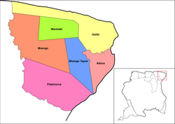
Marowijne is a district of Suriname, located on the north-east coast. Marowijne's capital city is Albina, with other towns including Moengo and Wanhatti. The district borders the Atlantic Ocean to the north, French Guiana to the east, the Surinamese district of Sipaliwini to the south, and the Surinamese districts of Commewijne and Para to the west.

<span class="mw-page-title-main">Sipaliwini District</span> District of Suriname

Sipaliwini is the largest district of Suriname, located in the south. Sipaliwini is the only district that does not have a regional capital, as it is directly administered by the national government in Paramaribo.

<span class="mw-page-title-main">Maroni (river)</span> River in South America, forming the border between Suriname and French Guiana

The Maroni or Marowijne is a river in South America that forms the border between French Guiana and Suriname.

<span class="mw-page-title-main">Albina, Suriname</span> Place in Marowijne District, Suriname

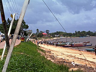
Albina is a town in eastern Suriname, and is capital of the Marowijne District. The town lies on the west bank of the Marowijne river, which forms the border with French Guiana, directly opposite the French Guianan town of Saint-Laurent-du-Maroni, to which it is connected by a frequent ferry service. Albina can be reached by bus via the East-West Link. The distance between Paramaribo and Albina is about 150 kilometres (95 mi).

<span class="mw-page-title-main">Moengo</span> Resort in Marowijne District, Suriname

Moengo is a town in Suriname, located in the Marowijne district, between Paramaribo and the border town Albina on the Cottica River. Moengo is also a resort (municipality) in the district of Marowijne. Moengo was the capital of Marowijne District between 1932 and 1945. The current capital is Albina.

<span class="mw-page-title-main">Awala-Yalimapo</span> Commune in French Guiana, France

Awala-Yalimapo is a commune on the north coast of French Guiana, close to the border with Suriname. The seat of the commune is the settlement of Awala where the town hall is located. Other settlements in the commune are: Yalimapo, Ayawande, and Piliwa. The majority of the inhabitants are Kaliña Amerindian people.

<span class="mw-page-title-main">Brownsweg</span> Town and Resort in Brokopondo, Suriname

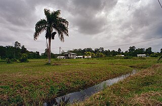
Brownsweg is a town and resort in Suriname in the Brokopondo District. Its population at the 2012 census was 4,793.

The (northern) East-West Link is a road in Suriname between Albina in the eastern part of the country to Nieuw Nickerie in the western part, via the capital city of Paramaribo. The southern East-West Link connects Paramaribo with Apoera via Bitagron. Construction of the road link started in the 1960s.

<span class="mw-page-title-main">Langatabiki</span> Village and island in the Pamacca Resort of Suriname

Langatabiki is a Paramacca village in the Sipaliwini District of Suriname. Langatabiki is the residence of the granman of the Paramaccan people. Langatabiki is located in the Pamacca resort which was created on 11 September 2019 out of Tapanahony.

<span class="mw-page-title-main">Pamacca</span> Resort in the Sipaliwini District of Suriname

Paramacca is a resort in Suriname, located in the Sipaliwini District. The population is estimated between 1,500 and 2,000 people. In 1983, the Sipaliwini District was created, and the eastern part became the resort of Tapanahony. The Paramacca resort is the northern part of Tapanahony, and mainly inhabited by the Paramaccan people, the border of the resorts is the island of Bofoo Tabiki in the Marowijne River.

<span class="mw-page-title-main">Braamspunt</span> Nature reserve and village in Commewijne District, Suriname

Braamspunt is a nature reserve, fishing village, and a former military outpost in the Johan & Margaretha resort of the Commewijne District of Suriname. Braamspunt is the most western point of the Commewijne District at the combined mouth of the Suriname and Commewijne River. The capital Paramaribo is located to the south of Braamspunt. The name is a corruption of Byam's Point which refers William Byam who was a quartermaster of Willoughby.

Alfonsdorp is a village of indigenous Lokono people in the Albina resort of the Marowijne District of Suriname. The village is located on the East-West Link. The Wanekreek Nature Reserve is located near the village.

<span class="mw-page-title-main">Amana Nature Reserve</span>

The Amana Nature Reserve is a nature reserve in French Guiana, France. It has been protected, because it is one of the world's largest leatherback turtle nesting site. It is part of the communes of Awala-Yalimapo and Mana.

Marijkedorp is a village of indigenous Lokono people in the Albina resort of the Marowijne District of Suriname. Grace Watamaleo has been the village captain since 2011.

Grace Betty Watamaleo is a Surinamese politician who has served as Captain of the indigenous village Marijkedorp since 2011. She was also a member of the National Assembly of Suriname from 2015 to 2020, representing Marowijne District for the National Democratic Party (NDP).

Sylvia Kajoeramari is a Surinamese politician. She was a member of the National Assembly from 2005 to 2010, representing Marowijne District for the Pertjajah Luhur (PL) party.

<span class="mw-page-title-main">Guianan marine ecoregion</span> Tropical marine ecoregion

The Guianan marine ecoregion stretches along the middle of the northeast coast of South America, touching Venezuela, Guyana, Suriname and French Guiana. It extends about 200 miles offshore, with the warm Guianan Current moving east-to-west through the region. This current brings in fresh, turbid waters from the mouth of the Amazon River to the east. As the current exits the ecoregion to the west it contributes an estimated 70% of the waters of the Caribbean Sea. A very large oil field has been recently discovered in the Guyana-Suriname Basin of the ecoregion. The Guianan is one of two ecoregions in the North Brazil Shelf province, a Large marine ecosystem (LME). The Guianan is thus part of the larger Tropical Atlantic realm.

References

  1. 1 2 "Resorts in Suriname Census 2012" (PDF). Retrieved 21 May 2020.
  2. 1 2 3 "Dorpen en Dorpsbesturen". Vereniging van Inheemse Dorpshoofden (in Dutch). Retrieved 25 February 2021.
  3. "Een geschiedenis van de Surinaamse literatuur. Deel 2". Digital Library for Dutch Literature (in Dutch). 2002. Retrieved 21 May 2020.
  4. Rowlett, Russ. "Lighthouses of Suriname". The Lighthouse Directory. University of North Carolina at Chapel Hill . Retrieved 21 May 2020.
  5. Albert Helman (1977). "Cultureel mozaïek van Suriname" (in Dutch). Zutphen: Walburg Pers. p. 350. ISBN   9060110730.
  6. 1 2 "District Marowijne". Bibi Onderweg (in Dutch). Retrieved 25 February 2021.
  7. 1 2 3 "STRUCTUUR ANALYSE DISTRICTEN 2009-2013" (PDF). Planning Office Suriname (in Dutch). Retrieved 22 May 2020.
  8. "Galibi Zoo". Columbus Magazine (in Dutch). Retrieved 25 February 2021.
  9. "Langamankondre installeert nieuw dorpshoofd". Dagblad Suriname (in Dutch). Retrieved 25 February 2021.
  10. 1 2 "Galibi Tour naar Galibi Zeeschildpadden". Galibi Suriname (in Dutch and English). Retrieved 19 May 2020.
  11. "Stichting Natuurbehoud Suriname". Stichting Natuurbehoud Suriname via Yellow.place (in Dutch). Retrieved 21 May 2020.
  12. Ouboter, Paul E. (2001). "Directory of protected areas of Suriname". IBER. p. 11.
  13. "Natuur". Suriname Weetjes (in Dutch). Retrieved 25 May 2020.
  14. "Galibi Suriname". Suriname Vakantiereis (in Dutch). Retrieved 21 May 2020.
  15. "Sylvia Kajoeramari van PL overgestapt naar ABOP". Star Nieuws (in Dutch). Retrieved 24 December 2021.
  16. "Koksijde vrijt met Albina". Parbode (in Dutch). Retrieved 23 December 2021.