Wageningen, Suriname

Last updated
Wageningen
Wageningen (2719363963).jpg
Mosque in Wageningen
Nickerie Resorts Suriname Neutral.png
Suriname location map.svg
Red pog.svg
Wageningen
Location in Suriname
Coordinates: 5°46′8″N56°41′11″W / 5.76889°N 56.68639°W / 5.76889; -56.68639
Country Flag of Suriname.svg Suriname
District Nickerie District
Area
  Total1,613 km2 (623 sq mi)
Elevation
1 m (3 ft)
Population
 (2012 census) [1]
  Total2,937
  Density1.8/km2 (4.7/sq mi)

Wageningen is a community resort and an agricultural place in the Republic of Suriname and located in the coastal area of West Suriname in the Nickerie District, at the harbour of the Nickerie River across the right estuary of the Maratakka River. The town was known as the rice centre of Suriname, [2] Wageningen has been founded in 1949 and named after the Dutch city of Wageningen.

Contents

Overview

Wageningen has the presence of large piece of fertile land, desired climate with enough rainfall and the absence of natural disasters. [3] The first trials in mechanized rice production started in 1933, and an area of 10,000 hectares (25,000 acres) was allocated for rice production. [4] The Stichting Machinale Landbouw (Foundation for mechanised agriculture) was founded on 27 July 1949 for the mechanized rice production and a town was constructed for the work force which mainly consisted of former military. The town was named Wageningen after the Dutch city, and university. [3]

The village of Wageningen is located about 54 kilometres (34 miles) east of New Nickerie, the main city of Nickerie District and 203 kilometres (126 miles) west of Paramaribo, the capital city of Suriname. Wageningen has a police office, an administrative office and a general practice center. [3] There is also a landing strip for small airplanes for agricultural purposes. In 1973, the four-metre (thirteen-foot) high statue Alida was placed in the central square of the village to commemorate 110 years since the abolition of slavery. The statue was created by George Barron and commissioned by Stichting Machinale Landbouw. [5]

During the 1980s a period of decline started in the rice production, [3] and in December 2010, Staatsolie announced a program of ethanol production from sugarcane. [6] The rice factory of Stichting Machinale Landbouw which closed down, restarted its operation in 2018. [7]

Lokono Shikuabana

Lokono Shikuabana (until 11 March 2013: Post Utrecht) [8] is an Indigenous village of the Lokono people [9] near Wageningen on the other side of the Nickerie River. The village is located at a former police outpost called Post Utrecht. [10] Lokono Shikuabana suffers from limited water supply, and only has electricity during the evening. [11] As of 2022, the population is about 115 people, and the village chief is Dorothy Marius-Lambert. [9]

Cupido

Cupido (also: Kipido; [12] location: 5°39′04″N56°40′54″W / 5.6512°N 56.6817°W / 5.6512; -56.6817 ) is an indigenous village of the Lokono people. [9] It is located on the Maratakka River about 20 kilometres from its mouth. [13] The village is built on sand hill overlooking the river [14] amongst swamp forests and savannas. [15] The population as of 2022 is 26 people, and the village chief is Runaldo Daniël. [9]

Related Research Articles

<span class="mw-page-title-main">Nickerie District</span> District of Suriname

Nickerie is a district of Suriname, on the north-west coast. Nickerie's capital city is Nieuw-Nickerie. Another town is Wageningen. The district borders the Atlantic Ocean to the north, the Surinamese district of Coronie to the east, the Surinamese district of Sipaliwini to the south and the region of East Berbice-Corentyne in Guyana to the west.

<span class="mw-page-title-main">Tiriyó people</span> Cariban ethnic group of Brazil, Suriname and Guyana

The Tiriyó are an Amerindian ethnic group native to parts of northern Brazil, Suriname, and Guyana. In 2014, there were approximately 3,640 Tiriyó in the three countries. They live in several major villages and a number of minor villages in the border zone between Brazil and Suriname. They speak the Tiriyó language, a member of the Cariban language family and refer to themselves as tarëno, etymologically 'people from here' or 'local people'.

<span class="mw-page-title-main">Albina, Suriname</span> Place in Marowijne District, Suriname

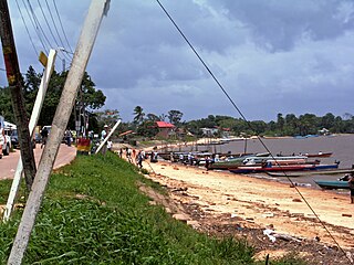
Albina is a town in eastern Suriname, and is capital of the Marowijne District. The town lies on the west bank of the Marowijne river, which forms the border with French Guiana, directly opposite the French Guianan town of Saint-Laurent-du-Maroni, to which it is connected by a frequent ferry service. Albina can be reached by bus via the East-West Link. The distance between Paramaribo and Albina is about 150 kilometres (95 mi).

Washabo is a town in Suriname, located in the Kabalebo resort of Sipaliwini district. The town lies on a bend in the Corantijn river (Courantyne), on the border with Guyana. Washabo is an indigenous village of the Lokono tribe near Apoera. It has a population of about 600 people. According to the oral tradition, the village was founded in the 1920s by the Lingaard family.

<span class="mw-page-title-main">Corneliskondre</span> Place in Sipaliwini District, Suriname

Corneliskondre is a village in Suriname, located in the Boven Coppename resort of Sipaliwini District. It has a population of 70 as of 2020, and is inhabited by indigenous people of the Kalina tribe.

Kwamalasamutu, also Kwamalasamoetoe, is a Tiriyó Amerindian village in the Sipaliwini District of Suriname, and home to the granman of the northern Trios. Kwamalasamutu is the biggest village of the Tiriyó tribe and is located near the disputed border with Guyana.

<span class="mw-page-title-main">Apoera</span> Place in Sipaliwini District, Suriname

Apoera, also Apura, is a town in western Suriname. The village has a population of 777 people as of 2020. It is the final destination of the Southern East-West Link. 24 kilometres (15 mi) north-west on the other side of the Courantyne River lies the Guyanese village of Orealla. The village is home to the Lokono tribe, but has been westernized. Due to the influx of people of Guyana, the languages used are English, and Sranan Tongo. Dutch is rarely spoken and the native language has all but disappeared. According to the oral tradition, Apoera was founded around 1920 by the Gordon family.

<span class="mw-page-title-main">Galibi, Suriname</span> Resort in Marowijne District, Suriname

Galibi is a resort in Suriname, located in the Marowijne District. Its population at the 2012 census was 741. Galibi is a tribal area inhabited by an indigenous population of Kalina Amerindians.

<span class="mw-page-title-main">Lensidede</span> Place in Sipaliwini District, Suriname

Lensidede or Lessé Dédé, is a Surinamese village on an island in the Lawa River, near the Lensidede rapids after which the village was named. In the village live Wayana people.

The Tucayana Amazonas was an Amerindian guerrilla commando group in Suriname.

<span class="mw-page-title-main">Redi Doti</span> Village in Para District, Suriname

Redi Doti is an indigenous village of Lokono and Kalina Amerindians in the resort of Carolina in the Para District in Suriname. The village is located near the site of Jodensavanne.

<span class="mw-page-title-main">Kalebaskreek</span> Village in Saramacca District, Suriname

Kalebaskreek is an indigenous village of Kalina Amerindians in the resort of Calcutta in the Saramacca District in Suriname.

Witsanti is an indigenous village of Lokono and Kalina Amerindians in the resort of Zuid in the Para District in Suriname. The village is located on the John F. Kennedyweg near the Johan Adolf Pengel International Airport.

<span class="mw-page-title-main">Cabendadorp</span> Village in Para District, Suriname

Cabendadorp is an indigenous village of Kalina Amerindians in the resort of Zuid in the Para District in Suriname. The village is located on the Avobakaweg south of the Johan Adolf Pengel International Airport.

<span class="mw-page-title-main">Powakka</span> Village in Para District, Suriname

Powakka is an indigenous village of Lokono Amerindians in the resort of Oost in the Para District in Suriname. The village is located on the road to Carolina which connects to the Avobakaweg to Paramaribo.

<span class="mw-page-title-main">Matta, Suriname</span> Village in Para District, Suriname

Matta is an indigenous village of Lokono Amerindians in the resort of Zuid in the Para District in Suriname. The village can be accessed from a road which branches off the Southern East-West Link.

Hollandse Kamp is an indigenous village of Lokono Amerindians in the resort of Zuid in the Para District in Suriname. The village is located south of the Johan Adolf Pengel International Airport.

Marijkedorp is a village of indigenous Lokono people in the Albina resort of the Marowijne District of Suriname. Grace Watamaleo has been the village captain since 2011.

Grace Betty Watamaleo is a Surinamese politician who has served as Captain of the indigenous village Marijkedorp since 2011. She was also a member of the National Assembly of Suriname from 2015 to 2020, representing Marowijne District for the National Democratic Party (NDP).

<span class="mw-page-title-main">Cassipora</span> Village in Para District, Suriname

Cassipora is an indigenous village of Lokono Amerindians located in the resort of Carolina in the Para District of Suriname. The village is situated near the Blaka Watra recreation area. It is also close to a 17th-century Jewish village; however, only the cemetery remains from that period.

References

  1. "2012 Census Resorts Suriname" (PDF). spangstaging.com. Retrieved 11 May 2020.
  2. "Wageningen". werkgroepcaraibischeletteren.nl (in Dutch). Werkgroep Caraibische Letteren (Working Group Caribbean Literature). Retrieved 14 May 2020.
  3. 1 2 3 4 "Het Plan Wageningen". sml-wageningen.com (in Dutch). SML-Wageningen, Delfgauw. Retrieved 29 December 2023.
  4. "Early senescence of rice and Drechslera oryzae in the Wageningen Polder, Surinam" (PDF). Wageningen University and Research . 1977. Retrieved 29 December 2023.
  5. "Herinneringen aan meester-beeldhouwer George Barron – Parbode Sneak Peek". Parbode (in Dutch). Retrieved 14 May 2020.
  6. "Rijst wordt suikerriet in Suriname's Wageningen". Waterkant.net (in Dutch). Retrieved 14 May 2020.
  7. "Doorstart rijstfabriek Stichting Machinale Landbouw in Suriname". Waterkant.net (in Dutch). Retrieved 18 May 2020.
  8. "Post Utrecht heet voortaan Lokono Shikuabana". Dagblad Suriname (in Dutch). Retrieved 18 May 2020.
  9. 1 2 3 4 "Dorpen en Dorpsbesturen". Vereniging van Inheemse Dorpshoofden in Suriname (in Dutch). Retrieved 25 June 2020.
  10. "Nickeriania". De Surinamer (in Dutch). 9 May 1920. Retrieved 11 January 2022.
  11. "Verificatie en Prioriteiten Stelling voor de Indigenous Navigator". Vereniging van Inheemse Dorpshoofden in Suriname (in Dutch). Retrieved 18 May 2020.
  12. "Een interessante tocht naar het District Nickerie". via Delpher.nl (in Dutch). 28 August 1951. Retrieved 11 January 2022.
  13. "Sranan Speciaal 2015, de aanloop – Wageningen en omgeving". Surinamazing (in Dutch). Retrieved 11 January 2022.
  14. "Naar de Maratakka". De West via Delpher.nl (in Dutch). 14 November 1916. Retrieved 11 January 2022.
  15. D.C. Geijskes. Reisverslag van de Expeditie West Suriname 1971 (PDF) (in Dutch). Leiden: Rijksmuseum van Natuurlijke Historie. p. 16.