Burton Parish, New Brunswick

Last updated

Burton
Sunbury County NB - Burton Parish.PNG
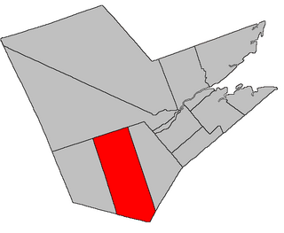
Location within Sunbury County, New Brunswick
Country Flag of Canada (Pantone).svg  Canada
Province Flag of New Brunswick.svg  New Brunswick
County Sunbury County
Erected1786
Area
[1]
  Land258.39 km2 (99.76 sq mi)
Population
 (2021) [1]
  Total5,176
  Density20.0/km2 (52/sq mi)
  Change 2016-2021
Increase2.svg 1.1%
  Dwellings
2,074
Time zone UTC-4 (AST)
  Summer (DST) UTC-3 (ADT)
Figures do not include portions within the town of Oromocto and the Oromocto 26 Indian reserve

Burton is a geographic parish in Sunbury County, New Brunswick, Canada. [2]

Contents

Prior to the 2023 governance reform, for governance purposes it was divided between the town of Oromocto, the Indian reserve of Oromocto 26, CFB Gagetown, and the local service district of the parish of Burton. [3] The town and LSD were both members of Capital Region Service Commission (RSC11). [4]

Origin of name

The parish was named in honour of Ralph Burton, military commander-in-chief in Montreal at the time of its establishment as a township. [5]

History

Burton was first established in 1765 as a Nova Scotia township. [6]

Burton was erected in 1786 as one of the original parishes of Sunbury County. [7] The parish extended further inland than the township. [8]

In 1835 the rear of the parish was included in the newly erected Blissville Parish. [9]

In 1896 the boundary with Blissville was altered along the Nerepis Road. [10]

In 1949 the boundary with Blissville was changed back to its pre-1896 course. [11]

Boundaries

Burton Parish is bounded: [2] [12] [13] [14]

Communities

Communities at least partly within the parish; [12] [13] [14] bold indicates an incorporated municipality or Indian reserve; italics indicate a community expropriated for CFB Gagetown

Bodies of water

Bodies of water [lower-alpha 2] at least partly in the parish: [12] [13] [14]

Islands

Islands in the parish: [12] [13] [14]

Other notable places

Parks, historic sites, and other noteworthy places in the parish. [12] [13] [14]

Demographics

Parish population total does not include Oromocto 26 Indian reserve and area within 2021 boundaries of Oromocto. Revised census figures based on the 2023 local governance reforms have not been released.

Access Routes

Highways and numbered routes that run through the parish, including external routes that start or finish at the parish limits: [21]

See also

Notes

  1. By the magnet of 1834 [15] when declination in the area was between 16º and 17º west of north. [16] The Territorial Division Act clause referring to magnetic direction bearings was omitted in the 1952 [17] and 1973 Revised Statutes. [2]
  2. Not including brooks, ponds or coves.

Related Research Articles

<span class="mw-page-title-main">Waterborough Parish, New Brunswick</span> Parish in New Brunswick, Canada

Waterborough is a geographic parish in Queens County, New Brunswick, Canada.

<span class="mw-page-title-main">Kingsclear Parish, New Brunswick</span> Parish in New Brunswick, Canada

Kingsclear is a geographic parish in York County, New Brunswick, Canada.

<span class="mw-page-title-main">Blissfield Parish, New Brunswick</span> Parish in New Brunswick, Canada

Blissfield is a geographic parish in Northumberland County, New Brunswick, Canada.

<span class="mw-page-title-main">Blissville Parish, New Brunswick</span> Parish in New Brunswick, Canada

Blissville is a geographic parish in Sunbury County, New Brunswick, Canada.

<span class="mw-page-title-main">Hampstead Parish, New Brunswick</span> Parish in New Brunswick, Canada

Hampstead is a geographic parish in Queens County, New Brunswick, Canada.

<span class="mw-page-title-main">Northampton Parish, New Brunswick</span> Parish in New Brunswick, Canada

Northampton is a geographic parish in Carleton County, New Brunswick, Canada, sitting across the Saint John River from Woodstock.

<span class="mw-page-title-main">Manners Sutton Parish, New Brunswick</span> Parish in New Brunswick, Canada

Manners Sutton is a geographic parish in York County, New Brunswick, Canada.

<span class="mw-page-title-main">New Maryland Parish, New Brunswick</span> Parish in New Brunswick, Canada

New Maryland is a geographic parish in York County, New Brunswick, Canada.

<span class="mw-page-title-main">Saint Marys Parish, New Brunswick</span> Parish in New Brunswick, Canada

Saint Marys is a geographic parish in York County, New Brunswick, Canada.

<span class="mw-page-title-main">Maugerville Parish, New Brunswick</span> Parish in New Brunswick, Canada

Maugerville is a geographic parish in Sunbury County, New Brunswick, Canada.

<span class="mw-page-title-main">Lincoln Parish, New Brunswick</span> Parish in New Brunswick, Canada

Lincoln is a geographic parish in Sunbury County, New Brunswick, Canada.

<span class="mw-page-title-main">Oromocto</span> Town in New Brunswick, Canada

Oromocto is a Canadian town in Sunbury County, New Brunswick.

<span class="mw-page-title-main">Harvey Parish, New Brunswick</span> Parish in New Brunswick, Canada

Harvey is a geographic parish in southern Albert County, New Brunswick, Canada.

<span class="mw-page-title-main">Petersville Parish, New Brunswick</span> Parish in New Brunswick, Canada

Petersville is a geographic parish in Queens County, New Brunswick, Canada.

<span class="mw-page-title-main">Clarendon Parish, New Brunswick</span> Parish in Canada

Clarendon is a geographic parish in Charlotte County, New Brunswick, Canada, located in the interior to the north of Point Lepreau and southwest of CFB Gagetown.

<span class="mw-page-title-main">Gagetown Parish, New Brunswick</span> Parish in New Brunswick, Canada

Gagetown is a geographic parish in Queens County, New Brunswick, Canada.

<span class="mw-page-title-main">Canning Parish, New Brunswick</span> Parish in New Brunswick, Canada

Canning is a geographic parish in Queens County, New Brunswick, Canada.

<span class="mw-page-title-main">Sheffield Parish, New Brunswick</span> Parish in New Brunswick, Canada

Sheffield is a geographic parish in Sunbury County, New Brunswick, Canada.

<span class="mw-page-title-main">Chipman Parish, New Brunswick</span> Parish in New Brunswick, Canada

Chipman is a geographic parish in Queens County, New Brunswick, Canada.

<span class="mw-page-title-main">Gladstone Parish, New Brunswick</span> Parish in New Brunswick, Canada

Gladstone is a geographic parish in Sunbury County, New Brunswick, Canada.

References

  1. 1 2 "Census Profile". Statistics Canada. 26 October 2022. Retrieved 29 October 2022.
  2. 1 2 3 "Chapter T-3 Territorial Division Act". Government of New Brunswick. Retrieved 13 November 2020.
  3. "New Brunswick Regulation 84-168 under the Municipalities Act (O.C. 84-582)". Government of New Brunswick. Retrieved 22 July 2020.
  4. "Communities in each of the 12 Regional Service Commissions (RSC) / Les communautés dans chacune des 12 Commissions de services régionaux (CSR)" (PDF), Government of New Brunswick, July 2017, retrieved 2 February 2021
  5. Ganong, William F. (1896). A Monograph of the Place-Nomenclature of the Province of New Brunswick. Royal Society of Canada. p. 223. Retrieved 17 March 2021.
  6. Ganong, William F. (1899). A Monograph of Historic Sites in the Province of New Brunswick. Royal Society of Canada. p. 333. Retrieved 27 March 2021.
  7. "26 Geo. III Chapter I. An Act for the better ascertaining and confirming the Boundaries of the several Counties within this Province, and for subdividing them into Towns or Parishes.". Acts of the General Assembly of His Majesty's Province of New-Brunswick, passed in the year 1786. Saint John, New Brunswick: Government of New Brunswick. 1786. pp. 3–12. Retrieved 20 March 2021.
  8. Ganong, Place-Nomenclature, page 431
  9. "4 Wm. IV c. 42 An Act to erect a new Parish in the County of Sunbury.". Acts of the General Assembly of His Majesty's Province of New Brunswick, Passed in the Year 1834. Fredericton: Government of New Brunswick. 1834. pp. 103–104. Retrieved 27 March 2021.
  10. "59 Vic. c. 8 An Act to Revise and Codify an Act to Provide for the Division of the Province into Counties, Towns and Parishes.". Acts of the General Assembly of Her Majesty's Province of New Brunswick. Passed in the Month of March, 1896. Fredericton: Government of New Brunswick. 1896. pp. 86–123. Available as a free ebook from Google Books.
  11. "13 Geo. VI c. 146 An Act to Amend Chapter 2 of the Revised Statutes, 1927, Respecting the Division of the Province into Counties Towns and Parishes, in so far as It Relates to the County of Sunbury.". Acts of the Legislative Assembly of New Brunswick Passed During the Session of 1949. Fredericton: Government of New Brunswick. 1949. p. 468.
  12. 1 2 3 4 5 "No. 126". Provincial Archives of New Brunswick. Department of Natural Resources and Energy Development. Retrieved 22 June 2021. Remainder of parish on maps 127, 137, and 138 at same site.
  13. 1 2 3 4 5 "391" (PDF). Transportation and Infrastructure. Government of New Brunswick. Retrieved 22 June 2021. Remainder of parish on mapbooks 392, 410, and 411 at same site.
  14. 1 2 3 4 5 "Search the Canadian Geographical Names Database (CGNDB)". Government of Canada. Retrieved 22 June 2021.
  15. "4 Wm. IV c. 42 An Act to erect a new Parish in the County of Sunbury.". Acts of the General Assembly of His Majesty's Province of New Brunswick, Passed in the Year 1834. Fredericton: Government of New Brunswick. 1834. pp. 103–104. Retrieved 27 March 2021.
  16. "Historical Magnetic Declination". National Oceanic and Atmospheric Administration. Retrieved 28 April 2021.
  17. "Chapter 227 Territorial Division Act". The Revised Statutes of New Brunswick 1952 Volume III. Fredericton: Government of New Brunswick. 1952. pp. 3725–3771.
  18. Statistics Canada: 2001, 2006 census
  19. 2011 Statistics Canada Census Profile: Burton Parish, New Brunswick
  20. 1 2 "Census Profile, 2016 Census: Burton, Parish [Census subdivision], New Brunswick". Statistics Canada. Retrieved 29 September 2019.
  21. Atlantic Canada Back Road Atlas ISBN   978-1-55368-618-7


45°48′05″N66°24′18″W / 45.8014°N 66.405°W / 45.8014; -66.405