Butler, South Dakota

Last updated

Butler, South Dakota
Day County South Dakota Incorporated and Unincorporated areas Butler Highlighted.svg
Location in Day County and the state of South Dakota
Coordinates: 45°15′43″N97°42′42″W / 45.26194°N 97.71167°W / 45.26194; -97.71167
Country United States
State South Dakota
County Day
Incorporated1905 [1]
Area
[2]
  Total0.29 sq mi (0.75 km2)
  Land0.29 sq mi (0.75 km2)
  Water0.00 sq mi (0.00 km2)
Elevation
[3]
1,814 ft (553 m)
Population
 (2020) [4]
  Total4
  Density13.75/sq mi (5.31/km2)
Time zone UTC-6 (Central (CST))
  Summer (DST) UTC-5 (CDT)
ZIP code
57219
Area code 605
FIPS code 46-08860 [5]
GNIS feature ID1267306 [3]

Butler is a town in Day County, South Dakota, United States. The population was 4 at the 2020 census. [6]

Contents

History

Butler was laid out in 1887, and named in honor of Harrison Butler, the original owner of the site. [7]

Geography

According to the United States Census Bureau, the town has a total area of 0.29 square miles (0.75 km2), all land. [8]

Demographics

Historical population
CensusPop.Note
1910 162
1920 156−3.7%
1930 18417.9%
1940 153−16.8%
1950 109−28.8%
1960 62−43.1%
1970 38−38.7%
1980 22−42.1%
1990 17−22.7%
2000 170.0%
2010 170.0%
2020 4−76.5%
U.S. Decennial Census [9] [4]

2010 census

As of the census [10] of 2010, there were 17 people, 9 households, and 6 families residing in the town. The population density was 58.6 inhabitants per square mile (22.6/km2). There were 12 housing units at an average density of 41.4 per square mile (16.0/km2). The racial makeup of the town was 100.0% White.

There were 9 households, of which 66.7% were married couples living together and 33.3% were non-families. 22.2% of all households were made up of individuals. The average household size was 1.89 and the average family size was 2.17.

The median age in the town was 53.5 years. 0.0% of residents were under the age of 18; 5.9% were between the ages of 18 and 24; 23.6% were from 25 to 44; 47% were from 45 to 64; and 23.5% were 65 years of age or older. The gender makeup of the town was 64.7% male and 35.3% female.

2000 census

As of the census [5] of 2000, there were 17 people, 6 households, and 6 families residing in the town. The population density was 27.9 inhabitants per square mile (10.8/km2). There were 7 housing units at an average density of 11.5 per square mile (4.4/km2). The racial makeup of the town was 100.00% White.

There were 6 households, out of which 50.0% had children under the age of 18 living with them, 83.3% were married couples living together, and 0.0% were non-families. No households were made up of individuals, and none had someone living alone who was 65 years of age or older. The average household size was 2.83 and the average family size was 2.83.

In the town, the population was spread out, with 23.5% under the age of 18, 23.5% from 25 to 44, 41.2% from 45 to 64, and 11.8% who were 65 years of age or older. The median age was 45 years. For every 100 females, there were 112.5 males. For every 100 females age 18 and over, there were 116.7 males.

The median income for a household in the town was $16,875, and the median income for a family was $16,875. Males had a median income of $21,250 versus $0 for females. The per capita income for the town was $8,371. Below the poverty line were 23.8% of people, 28.6% of families, 40.0% of those under 18 and 33.3% of those over 64.

Related Research Articles

<span class="mw-page-title-main">Hardy, Iowa</span> City in Iowa, United States

Hardy is a city in Humboldt County, Iowa, United States. The population was 57 at the time of the 2020 census.

Deblois is a town in Washington County, Maine, United States. The town was named after T.A. Deblois, president of the Bank of Portland. The population was 74 at the 2020 census.

<span class="mw-page-title-main">Kelliher, Minnesota</span> Town in Minnesota, United States

Kelliher is a city in Beltrami County, Minnesota, United States. The population was 258 at the 2020 census. Minnesota State Highway 72 is the primary route through Kelliher.

<span class="mw-page-title-main">Nome, North Dakota</span> City in North Dakota, United States

Nome is a city in Barnes County, North Dakota, United States. The population was 51 at the 2020 census. Nome was founded in 1901.

<span class="mw-page-title-main">Kramer, North Dakota</span> City in North Dakota, United States

Kramer is a city in Bottineau County, North Dakota, United States. The population was 24 at the 2020 census. Kramer was founded in 1905.

<span class="mw-page-title-main">Forbes, North Dakota</span> City in North Dakota, United States

Forbes is a city in Dickey County, North Dakota, United States. The population was 36 at the 2020 census.

<span class="mw-page-title-main">Ross, North Dakota</span> City in North Dakota, United States

Ross is a city in Mountrail County, North Dakota, United States. The population was 95 at the 2020 census.

<span class="mw-page-title-main">Michigan City, North Dakota</span> City in North Dakota, United States

Michigan City is a city in Nelson County, North Dakota, United States. The population was 263 at the 2020 census. Though the official name is Michigan City, local residents commonly refer to the city as Michigan. The town population has been declining since the 1980 census.

<span class="mw-page-title-main">Lawton, North Dakota</span> City in North Dakota, United States

Lawton is a city in Ramsey County, North Dakota, United States. The population was 15 at the 2020 census. Lawton was founded in 1902.

<span class="mw-page-title-main">Conway, North Dakota</span> City in North Dakota, United States

Conway is a city in Walsh County, North Dakota, United States. The population was 15 at the 2020 census. Conway was founded in 1885.

<span class="mw-page-title-main">Westport, South Dakota</span> Town in South Dakota, United States

Westport is a town in western Brown County, South Dakota, United States. The population was 88 at the 2020 census.

<span class="mw-page-title-main">Vienna, South Dakota</span> Town in South Dakota, United States

Vienna is a town in Clark County, South Dakota, United States. The population was 49 at the 2020 census.

<span class="mw-page-title-main">Grenville, South Dakota</span> Town in South Dakota, United States

Grenville is a town in Day County, South Dakota, United States. The population was 48 at the 2020 census.

<span class="mw-page-title-main">Altamont, South Dakota</span> Town in South Dakota, United States

Altamont is a town in Deuel County, South Dakota, United States. The population was 32 at the 2020 census.

<span class="mw-page-title-main">Chelsea, South Dakota</span> Town in South Dakota, United States

Chelsea is a town in Faulk County, South Dakota, United States. The population was 19 at the 2020 census.

<span class="mw-page-title-main">Orient, South Dakota</span> Town in South Dakota, United States

Orient is a town in Faulk County, South Dakota, United States. The population was 51 at the 2020 census.

<span class="mw-page-title-main">Erwin, South Dakota</span> Town in South Dakota, United States

Erwin is a town in Kingsbury County, South Dakota, United States. The population was 45 at the 2010 census.

<span class="mw-page-title-main">Sherman, South Dakota</span> Town in South Dakota, United States

Sherman is a town in Minnehaha County, South Dakota, United States. The population was 81 at the 2020 census.

<span class="mw-page-title-main">Rosholt, South Dakota</span> Town in South Dakota, United States

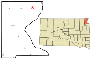
Rosholt is a town in Roberts County, South Dakota, United States. The population was 379 at the 2020 census.

<span class="mw-page-title-main">Kingston, Juneau County, Wisconsin</span> Town in Wisconsin, United States

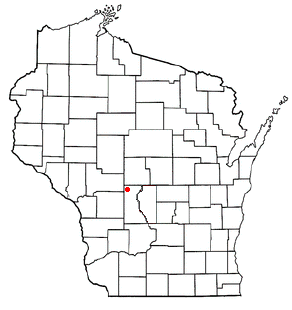
Kingston is a town in Juneau County, Wisconsin, United States. Its population was 58 at the 2000 census. The unincorporated communities of Mather and Meadow Valley are located in the town.

References

  1. "SD Towns" (PDF). South Dakota State Historical Society. Archived from the original (PDF) on February 10, 2010. Retrieved February 11, 2010.
  2. "ArcGIS REST Services Directory". United States Census Bureau. Retrieved October 15, 2022.
  3. 1 2 U.S. Geological Survey Geographic Names Information System: Butler, South Dakota
  4. 1 2 "Census Population API". United States Census Bureau. Retrieved October 15, 2022.
  5. 1 2 "U.S. Census website". United States Census Bureau . Retrieved January 31, 2008.
  6. "U.S. Census Bureau: Butler town, South Dakota". www.census.gov. United States Census Bureau. Retrieved March 22, 2022.
  7. Federal Writers' Project (1940). South Dakota place-names, v.1-3. University of South Dakota. p. 29.
  8. "US Gazetteer files 2010". United States Census Bureau. Archived from the original on January 25, 2012. Retrieved June 21, 2012.
  9. "Census of Population and Housing". Census.gov. Retrieved June 4, 2015.
  10. "U.S. Census website". United States Census Bureau . Retrieved June 21, 2012.