Byrdstown, Tennessee

Last updated

Byrdstown, Tennessee
Town
Byrdstown-overview-tn1.jpg
Town square in Byrdstown
Pickett County Tennessee Incorporated and Unincorporated areas Byrdstown Highlighted 4710180.svg
Location of Byrdstown in Pickett County, Tennessee.
Coordinates: 36°34′N85°8′W / 36.567°N 85.133°W / 36.567; -85.133
CountryUnited States
State Tennessee
County Pickett
Founded1879
Incorporated1917 [1]
Named for Col. Robert K. Byrd
Area
[2]
  Total1.49 sq mi (3.85 km2)
  Land1.49 sq mi (3.85 km2)
  Water0.00 sq mi (0.00 km2)
Elevation
[3]
1,037 ft (316 m)
Population
 (2020) [4]
  Total798
  Density536.29/sq mi (207.10/km2)
Time zone UTC-6 (Central (CST))
  Summer (DST) UTC-5 (CDT)
ZIP code
38549
Area code 931
FIPS code 47-10180 [5]
GNIS feature ID1279260 [3]
Website www.townofbyrdstown.com

Byrdstown is a town in Pickett County, Tennessee, United States. The population was 798 at the 2020 census. [6] It is the county seat of Pickett County. [7]

Contents

History

Byrdstown was established in 1879 as a county seat for the newly formed Pickett County. The town, where several families already lived, was named for Colonel Robert K. Byrd, a state senator whose district included the new county. Byrdstown was officially incorporated in 1917.

Former Secretary of State Cordell Hull (1871–1955) who played a pivotal role in the creation of the United Nations was born just west of Byrdstown. The Pickett County Courthouse, built in 1935, and the Cordell Hull Birthplace are both listed on the National Register of Historic Places. Other historical sites include the Amonett House at the junction of TN-325 and TN-111. [8] [9]

Geography

Byrdstown is located at 36°34′21″N85°8′14″W / 36.57250°N 85.13722°W / 36.57250; -85.13722 (36.572585, -85.137088). [10] The town is situated in a hilly area on the Highland Rim, a few miles south of the Kentucky state line. Byrdstown lies south of the Wolf River, north of the Obey River, and east of Dale Hollow Lake, where the two rivers converge.

Dale Hollow Lake near Byrdstown DaleHollowLakeAerial.jpg
Dale Hollow Lake near Byrdstown

Tennessee State Route 325 traverses Byrdstown from west to east, mostly following West Main Street and East Main Street. This highway connects Byrdstown with the Dale Hollow Lake and Cordell Hull Birthplace State Park areas to the west, and the rural parts of central Pickett County to the east. Tennessee State Route 111, which intersects SR 325 in western Byrdstown, connects the town with Livingston to the southwest, and Static at the state line to the north. At Static, the highway terminates at an intersection with U.S. Route 127, with the latter continuing northward to Albany, Kentucky.

According to the United States Census Bureau, the town has a total area of 1.5 square miles (3.9 km2), all of it land.

Climate

Climate data for Byrdstown, Tennessee, 1991–2020 normals, extremes 1998present
MonthJanFebMarAprMayJunJulAugSepOctNovDecYear
Record high °F (°C)77
(25)
79
(26)
87
(31)
90
(32)
91
(33)
100
(38)
101
(38)
100
(38)
96
(36)
96
(36)
84
(29)
81
(27)
101
(38)
Mean maximum °F (°C)66.7
(19.3)
71.6
(22.0)
79.3
(26.3)
85.3
(29.6)
86.7
(30.4)
90.3
(32.4)
91.0
(32.8)
90.7
(32.6)
89.9
(32.2)
85.6
(29.8)
76.3
(24.6)
70.3
(21.3)
93.2
(34.0)
Mean daily maximum °F (°C)45.7
(7.6)
50.2
(10.1)
59.1
(15.1)
69.6
(20.9)
75.6
(24.2)
82.1
(27.8)
84.5
(29.2)
84.4
(29.1)
79.7
(26.5)
70.3
(21.3)
59.1
(15.1)
49.2
(9.6)
67.5
(19.7)
Daily mean °F (°C)36.2
(2.3)
39.7
(4.3)
47.7
(8.7)
56.9
(13.8)
65.0
(18.3)
72.4
(22.4)
75.6
(24.2)
74.4
(23.6)
68.5
(20.3)
57.9
(14.4)
47.3
(8.5)
39.8
(4.3)
56.8
(13.8)
Mean daily minimum °F (°C)26.7
(−2.9)
29.2
(−1.6)
36.2
(2.3)
44.2
(6.8)
54.3
(12.4)
62.6
(17.0)
66.6
(19.2)
64.4
(18.0)
57.3
(14.1)
45.4
(7.4)
35.5
(1.9)
30.3
(−0.9)
46.1
(7.8)
Mean minimum °F (°C)7.1
(−13.8)
12.1
(−11.1)
20.0
(−6.7)
28.4
(−2.0)
38.3
(3.5)
51.7
(10.9)
56.3
(13.5)
55.4
(13.0)
45.5
(7.5)
30.7
(−0.7)
20.5
(−6.4)
16.2
(−8.8)
5.5
(−14.7)
Record low °F (°C)−9
(−23)
−6
(−21)
8
(−13)
19
(−7)
32
(0)
43
(6)
51
(11)
49
(9)
35
(2)
24
(−4)
13
(−11)
−3
(−19)
−9
(−23)
Average precipitation inches (mm)4.52
(115)
4.96
(126)
5.01
(127)
5.19
(132)
4.90
(124)
4.74
(120)
5.28
(134)
4.09
(104)
3.62
(92)
3.27
(83)
3.68
(93)
5.32
(135)
54.58
(1,385)
Average precipitation days (≥ 0.01 in)13.713.113.612.312.211.411.810.38.19.810.313.5140.1
Source 1: NOAA [11]
Source 2: National Weather Service (mean maxima/minima 20062020) [12]

Demographics

Historical population
CensusPop.Note
1920 125
1930 1358.0%
1940 21559.3%
1950 37976.3%
1960 61361.7%
1970 582−5.1%
1980 88451.9%
1990 99812.9%
2000 903−9.5%
2010 803−11.1%
2020 798−0.6%
Sources: [13] [14] [4]

2020 census

Byrdstown racial composition [15]
RaceNumberPercentage
White (non-Hispanic)73091.48%
Black or African American (non-Hispanic)10.13%
Asian 20.25%
Other/Mixed 283.51%
Hispanic or Latino 374.64%

As of the 2020 United States census, there were 798 people, 409 households, and 246 families residing in the town.

2000 census

As of the census [5] of 2000, there were 903 people, 395 households, and 233 families residing in the town. The population density was 587.5 inhabitants per square mile (226.8/km2). There were 460 housing units at an average density of 299.3 per square mile (115.6/km2). The racial makeup of the town was 98.12% White, 0.22% African American, 0.44% Native American, and 1.22% from two or more races. Hispanic or Latino of any race were 0.55% of the population.

Byrdstown Town Hall Byrdstown-Town-Hall-tn1.jpg
Byrdstown Town Hall

There were 395 households, out of which 24.1% had children under the age of 18 living with them, 39.7% were married couples living together, 14.9% had a female householder with no husband present, and 41.0% were non-families. 37.7% of all households were made up of individuals, and 18.7% had someone living alone who was 65 years of age or older. The average household size was 2.11 and the average family size was 2.80.

In the town, the population was spread out, with 19.8% under the age of 18, 9.7% from 18 to 24, 22.4% from 25 to 44, 23.9% from 45 to 64, and 24.1% who were 65 years of age or older. The median age was 43 years. For every 100 females, there were 81.0 males. For every 100 females age 18 and over, there were 75.7 males.

The median income for a household in the town was $19,375, and the median income for a family was $25,938. Males had a median income of $23,281 versus $16,389 for females. The per capita income for the town was $14,462. About 19.2% of families and 28.1% of the population were below the poverty line, including 40.4% of those under age 18 and 32.5% of those age 65 or over.

Notable residents

Related Research Articles

<span class="mw-page-title-main">Putnam County, Tennessee</span> County in Tennessee, United States

Putnam County is a county located in the U.S. state of Tennessee. As of the 2020 census, the population was 79,854. Its county seat is Cookeville. Putnam County is part of the Cookeville, TN Micropolitan Statistical Area.

<span class="mw-page-title-main">Clay County, Tennessee</span> County in Tennessee, United States

Clay County is a county in the U.S. state of Tennessee. As of the 2020 census, the population was 7,581. Its county seat and only incorporated city is Celina. Clay County is named in honor of American statesman Henry Clay, member of the United States Senate from Kentucky and United States Secretary of State in the 19th century.

<span class="mw-page-title-main">Smith County, Tennessee</span> County in Tennessee, United States

Smith County is a county in the U.S. state of Tennessee. As of the 2020 census, the population was 19,904. Smith County is located in the region of the state known as Middle Tennessee. Its county seat is Carthage. The county was organized in 1799 and is named for Daniel Smith, a Revolutionary War veteran who made the first map of Tennessee and served as a United States senator.

<span class="mw-page-title-main">Pickett County, Tennessee</span> County in Tennessee, United States

Pickett County is a county located in the U.S. state of Tennessee. As of the 2020 census, the population was 5,001, making it the least populous county in Tennessee. Its county seat is Byrdstown. The city of Byrdstown and the Kentucky town of Albany, 11 miles (18 km) to the northeast, are positioned between two Army Corps of Engineers lakes: Dale Hollow Lake, mainly in Tennessee, and Lake Cumberland, in Kentucky. The area is known as "Twin Lakes" and Byrdstown is noted as "The Gateway To Dale Hollow Lake". Every year thousands of people vacation at the many resorts situated along the lakes.

<span class="mw-page-title-main">Overton County, Tennessee</span> County in Tennessee, United States

Overton County is a county located in the U.S. state of Tennessee. As of the 2020 census, the population was 22,511. Its county seat is Livingston. Overton County is part of the Cookeville, TN Micropolitan Statistical Area.

<span class="mw-page-title-main">Jackson County, Tennessee</span> County in Tennessee, United States

Jackson County is a county located in the U.S. state of Tennessee. The population was 11,617 at the 2020 census. Its county seat is Gainesboro. Jackson is part of the Cookeville Micropolitan Statistical Area.

Jonesboro is a town in Washington County, Maine, United States. The town was named for John Coffin Jones, a landholder. The population was 587 at the 2020 census.

<span class="mw-page-title-main">Celina, Tennessee</span> City in Tennessee, United States

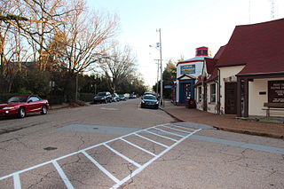
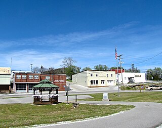
Celina is a city in and the county seat of Clay County, Tennessee, United States. The population was 1,495 at the 2010 census.

<span class="mw-page-title-main">Palmer, Tennessee</span> Town in Tennessee, United States

Palmer is a town in Grundy County, Tennessee, United States. The population was 672 at the 2010 census.

<span class="mw-page-title-main">Lookout Mountain, Tennessee</span> Town in Tennessee, United States

Lookout Mountain is a town in Hamilton County, Tennessee, United States. The population was 2,058 at the 2020 census. Bordering its sister city of Lookout Mountain, Georgia to the south, Lookout Mountain is part of the Chattanooga, TN–GA Metropolitan Statistical Area.

<span class="mw-page-title-main">Kimball, Tennessee</span> Town in Tennessee, United States

Kimball is a town in Marion County, Tennessee, United States. The population was 1,545 at the 2020 census and 1,395 in 2010. It is part of the Chattanooga, TN–GA Metropolitan Statistical Area.

<span class="mw-page-title-main">Chapel Hill, Tennessee</span> Town in Tennessee, United States

Chapel Hill is a town in northeastern Marshall County, Tennessee, United States. The town was named after Chapel Hill, North Carolina, by settlers from that area. The population was 1,717 as of the 2020 census.

<span class="mw-page-title-main">Livingston, Tennessee</span> Town in Tennessee, United States

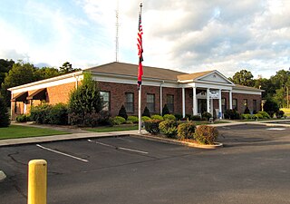
Livingston is a town in Overton County, Tennessee, United States, and serves as the county seat. The population was 3,905 at the 2020 census and 4,058 at the 2010 census. The current mayor, Curtis Hayes, began serving his mayoral position in September 2006.

<span class="mw-page-title-main">Graysville, Tennessee</span> Town in Tennessee, United States

Graysville is a town in Rhea County, Tennessee, United States. The population was 1,471 at the 2020 census and 1,502 at the 2010 census.

<span class="mw-page-title-main">Carthage, Tennessee</span> Town in Tennessee, United States

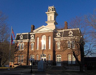
Carthage is a town in and the county seat of Smith County, Tennessee, United States; it is part of the Nashville Metropolitan Statistical Area. The population was 2,306 at the 2010 census. It is located on the Cumberland River, which was important to its early development. It is likely best known as the hometown of former Vice President and Senator Al Gore of the Democratic Party and his father, Senator Albert Gore, Sr. The younger Gore announced his 1988 and 2000 presidential bids, as well as his 1992 vice-presidential bid, from the steps of the Smith County Courthouse.

<span class="mw-page-title-main">South Carthage, Tennessee</span> Town in Tennessee, United States

South Carthage is a town in Smith County, Tennessee, United States. The population was 1,322 at the 2010 census. The town is located along the Cumberland River opposite Carthage.

<span class="mw-page-title-main">Centertown, Tennessee</span> Town in Tennessee, United States

Centertown is a town in Warren County, Tennessee, United States. The population was 243 at the 2010 census.

<span class="mw-page-title-main">Henderson, West Virginia</span> Unincorporated Town in West Virginia, United States

Henderson is an unincorporated community and former town in Mason County, West Virginia, United States, at the confluence of the Ohio and Kanawha Rivers. The population was 231 at the 2020 census. It is part of the Point Pleasant, WV–OH Micropolitan Statistical Area. The town was incorporated in 1893 and named for Samuel Bruce Henderson, who owned the townsite at the time. The town was unincorporated following a public hearing on August 11, 2022.

<span class="mw-page-title-main">McKenzie, Tennessee</span> City in Tennessee, United States

McKenzie is a city at the tripoint of Carroll, Henry, and Weakley counties in Tennessee, United States. The population was 5,310 at the 2010 census.

<span class="mw-page-title-main">Kenton, Tennessee</span> Town in Tennessee, United States

Kenton is a town in Gibson and Obion counties, Tennessee. The population was 1,281 at the 2010 census, a decline of 25 from 2000. The Gibson County portion of Kenton is part of the Humboldt, TN Micropolitan Statistical Area, while the Obion County portion is part of the Union City, TN–KY Micropolitan Statistical Area.

References

  1. Tennessee Blue Book , 2005-2006, pp. 618-625.
  2. "ArcGIS REST Services Directory". United States Census Bureau. Retrieved October 15, 2022.
  3. 1 2 U.S. Geological Survey Geographic Names Information System: Byrdstown, Tennessee
  4. 1 2 "Census Population API". United States Census Bureau. Retrieved October 15, 2022.
  5. 1 2 "U.S. Census website". United States Census Bureau . Retrieved January 31, 2008.
  6. Tennessee Department of Economic and Community Development, Certified Population of Tennessee Incorporated Municipalities and Counties Archived June 30, 2014, at the Wayback Machine , State of Tennessee official website, July 14, 2011. Retrieved: December 6, 2013.
  7. "Find a County". National Association of Counties. Archived from the original on May 31, 2011. Retrieved June 7, 2011.
  8. "History of Pickett County, Tennessee Archived 2008-05-09 at the Wayback Machine ." Overton County/Pickett County E-911. Retrieved: December 19, 2007.
  9. The Federal Writers' Project, The WPA Guide to Tennessee (Knoxville, Tenn.: University of Tennessee Press, 1986), 507.
  10. "US Gazetteer files: 2010, 2000, and 1990". United States Census Bureau. February 12, 2011. Retrieved April 23, 2011.
  11. "U.S. Climate Normals Quick Access – Station: Byrdstown, TN". National Oceanic and Atmospheric Administration. Retrieved February 27, 2023.
  12. "NOAA Online Weather Data – NWS Nashville". National Weather Service. Retrieved February 27, 2023.
  13. "Census of Population and Housing: Decennial Censuses". United States Census Bureau . Retrieved March 4, 2012.
  14. "Incorporated Places and Minor Civil Divisions Datasets: Subcounty Resident Population Estimates: April 1, 2010 to July 1, 2012". Population Estimates. U.S. Census Bureau. Archived from the original on June 11, 2013. Retrieved December 11, 2013.
  15. "Explore Census Data". data.census.gov. Retrieved December 26, 2021.