Selmer, Tennessee | |
---|---|
Town of Selmer | |
Coordinates: 35°10′20″N88°35′35″W / 35.17222°N 88.59306°W | |
Country | United States |
State | Tennessee |
County | McNairy |
Incorporated | 1901 [1] |
Named for | Selma, Alabama [2] |
Government | |
• Mayor | Sherry Inman [3] |
Area | |
• Total | 9.57 sq mi (24.79 km2) |
• Land | 9.55 sq mi (24.73 km2) |
• Water | 0.02 sq mi (0.05 km2) |
Elevation | 449 ft (137 m) |
Population | |
• Total | 4,446 |
• Density | 465.55/sq mi (179.76/km2) |
Time zone | UTC-6 (Central (CST)) |
• Summer (DST) | UTC-5 (CDT) |
ZIP code | 38375 |
Area code | 731 |
FIPS code | 47-66940 [6] |
GNIS feature ID | 1301051 [7] |
Website | townofselmer |
Selmer is a Town in and the county seat of McNairy County, Tennessee, [8] in the southwestern part of the state. The population was 4,446 as of the 2020 census. It is named after Selma, Alabama.
Selmer, Tennessee, operates under a municipal governance system comprised of a Mayor and a Board of Aldermen, all of whom are elected officials. Unlike some municipalities where Aldermen represent specific districts or wards, Selmer's Aldermen serve the town at large. This setup fosters a collaborative approach to decision-making, ensuring that the entire town's interests are represented and addressed. The Mayor, along with the Aldermen, oversees various aspects of local governance, including public services, infrastructure development, and community initiatives. Through regular meetings and public engagement, Selmer's elected officials work diligently to uphold transparency, accountability, and the well-being of the town's residents.
Census | Pop. | Note | %± |
---|---|---|---|
1900 | 588 | — | |
1910 | 529 | −10.0% | |
1920 | 546 | 3.2% | |
1930 | 925 | 69.4% | |
1940 | 957 | 3.5% | |
1950 | 1,759 | 83.8% | |
1960 | 1,897 | 7.8% | |
1970 | 3,495 | 84.2% | |
1980 | 3,979 | 13.8% | |
1990 | 3,838 | −3.5% | |
2000 | 4,541 | 18.3% | |
2010 | 4,396 | −3.2% | |
2020 | 4,446 | 1.1% | |
Sources: [9] [10] [5] |
Race / Ethnicity | Pop 2000 [11] | Pop 2010 [12] | Pop 2020 [13] | % 2000 | % 2010 | % 2020 |
---|---|---|---|---|---|---|
White alone (NH) | 3,657 | 3,545 | 3,425 | 80.53% | 80.64% | 77.04% |
Black or African American alone (NH) | 722 | 636 | 658 | 15.90% | 14.47% | 14.80% |
Native American or Alaska Native alone (NH) | 8 | 14 | 14 | 0.18% | 0.32% | 0.31% |
Asian alone (NH) | 12 | 22 | 25 | 0.26% | 0.50% | 0.56% |
Pacific Islander alone (NH) | 0 | 0 | 0 | 0.00% | 0.00% | 0.00% |
Some Other Race alone (NH) | 0 | 1 | 11 | 0.00% | 0.02% | 0.25% |
Mixed Race/Multi-Racial (NH) | 72 | 87 | 203 | 1.59% | 1.98% | 4.57% |
Hispanic or Latino (any race) | 70 | 91 | 110 | 1.54% | 2.07% | 2.47% |
Total | 4,541 | 4,396 | 4,446 | 100.00% | 100.00% | 100.00% |
As of the 2020 United States census, there were 4,446 people, 1,669 households, and 1,104 families residing in the city.
As of the census [6] of 2020, there were 4,446 people, 1,783 households, and 1,069 families residing in the Town. The racial makeup of the Town was 77.81% White, 14.82% African American, 0.31% Native American, 0.56% Asian, 1,21% from other races, and 5.27% from two or more races. Hispanic or Latino of any race were 2.47% of the population.
There were 1,783 households, out of which 20.2% had children under the age of 18 living with them, 39.4% were married couples living together, 27.0% had a female householder with no husband present, and 20.3% were non-families. 14.6% had someone living alone who was 65 years of age or older. The average household size was 2.37 and the average family size was 3.21.
In the Town, the population was spread out, with 18.9% under the age of 18, 7.4% from 18 to 24, 31.1% from 25 to 44, 25% from 45 to 64, and 17.5% who were 65 years of age or older. The median age was 38.6 years. For every 100 females, there were 114.8 males.
The median income for a household in the Town was $46,696, and the median income for a family was $68,503. Males living alone had a median income of $45,412 versus $19,075 for females. The per capita income for the city was $21,350. About 14.3% of families and 18.5% of the population were below the poverty line, including 9.2% of those under age 18 and 23.6% of those age 65 or over.
Selmer is located at 35°10′20″N88°35′35″W / 35.17222°N 88.59306°W (35.172333, -88.592964). [14]
According to the United States Census Bureau, the Town has a total area of 9.8 square miles (25 km2), all land.
The major highways U.S. Route 64 (east-west), and U.S. Route 45 (north-south) intersect in the city, making it an important crossroads. In 2009 the Tennessee Legislature designated Highway 45 South, between Interstate 40 and the Mississippi state line, Rockabilly Highway in recognition of the region's contributions to the development of rockabilly music.
The railroad that runs through the Town is owned by Class 1 railroad, Norfolk Southern, and is operated by West Tennessee Railroad.
The Robert Sibley Airport (IATA airport code SZY (ICAO: KSZY)) is located in the area, with no ATC, a 5,002-foot (1,525 m) runway, and at 610 feet (190 m) above sea level. The UN/LOCODE for the city is USSQE.
Climate data for Selmer, Tennessee (1991–2020 normals, extremes 1958–present) | |||||||||||||
---|---|---|---|---|---|---|---|---|---|---|---|---|---|
Month | Jan | Feb | Mar | Apr | May | Jun | Jul | Aug | Sep | Oct | Nov | Dec | Year |
Record high °F (°C) | 78 (26) | 84 (29) | 89 (32) | 92 (33) | 96 (36) | 107 (42) | 106 (41) | 107 (42) | 101 (38) | 97 (36) | 87 (31) | 77 (25) | 107 (42) |
Mean daily maximum °F (°C) | 49.1 (9.5) | 53.7 (12.1) | 62.8 (17.1) | 72.7 (22.6) | 80.3 (26.8) | 87.4 (30.8) | 90.3 (32.4) | 89.7 (32.1) | 84.3 (29.1) | 73.8 (23.2) | 61.8 (16.6) | 51.9 (11.1) | 71.5 (21.9) |
Daily mean °F (°C) | 39.3 (4.1) | 43.1 (6.2) | 51.4 (10.8) | 60.4 (15.8) | 68.9 (20.5) | 76.5 (24.7) | 79.8 (26.6) | 78.8 (26.0) | 72.6 (22.6) | 61.1 (16.2) | 50.1 (10.1) | 42.2 (5.7) | 60.4 (15.8) |
Mean daily minimum °F (°C) | 29.5 (−1.4) | 32.5 (0.3) | 39.9 (4.4) | 48.2 (9.0) | 57.6 (14.2) | 65.7 (18.7) | 69.3 (20.7) | 67.8 (19.9) | 60.8 (16.0) | 48.5 (9.2) | 38.4 (3.6) | 32.5 (0.3) | 49.2 (9.6) |
Record low °F (°C) | −21 (−29) | −11 (−24) | 7 (−14) | 22 (−6) | 29 (−2) | 39 (4) | 47 (8) | 45 (7) | 30 (−1) | 22 (−6) | 5 (−15) | −14 (−26) | −21 (−29) |
Average precipitation inches (mm) | 4.69 (119) | 5.30 (135) | 5.75 (146) | 5.64 (143) | 5.36 (136) | 4.79 (122) | 5.17 (131) | 3.84 (98) | 4.35 (110) | 4.14 (105) | 4.37 (111) | 5.66 (144) | 59.06 (1,500) |
Average snowfall inches (cm) | 0.3 (0.76) | 0.4 (1.0) | 0.2 (0.51) | 0.1 (0.25) | 0.0 (0.0) | 0.0 (0.0) | 0.0 (0.0) | 0.0 (0.0) | 0.0 (0.0) | 0.0 (0.0) | 0.0 (0.0) | 0.0 (0.0) | 1.0 (2.5) |
Average precipitation days (≥ 0.01 in) | 11.5 | 11.2 | 11.8 | 10.5 | 11.1 | 9.6 | 9.7 | 8.6 | 6.8 | 7.3 | 9.5 | 11.5 | 119.1 |
Average snowy days (≥ 0.1 in) | 0.3 | 0.3 | 0.1 | 0.1 | 0.0 | 0.0 | 0.0 | 0.0 | 0.0 | 0.0 | 0.0 | 0.0 | 0.8 |
Source: NOAA [15] [16] |
The Rockabilly Highway Revival is an annual event held in downtown Selmer to commemorate its rich musical heritage.
Sheriff Buford Pusser served as the sheriff of McNairy County from 1964 to 1970. Selmer, as the county seat, is the location of the courthouse and old jail, which was his base of operations. His story has been made famous in the Walking Tall movies starring Joe Don Baker and Bo Svenson. The movies were filmed in nearby Henderson.
The oldest existing business in McNairy County is newspaper publisher, Independent Appeal, which was founded in 1902. The Independent Appeal discontinued the print edition of its' newspapers on December 28, 2022 and transitioned to a strictly online presence. [17]
The McNairy County News began publication in 2009. The paper has an online presence at mcnairycountynews.com and a Facebook page, as well as a weekly printed publication each Thursday.
Selmer became a focus of national news media in late March 2006. A local minister, Matthew Brian Winkler, was shot to death by his wife Mary Carol Winkler at their Selmer home. After Mary was said to have fled Selmer with the couple's three daughters, she was apprehended in Orange Beach, Alabama, and was returned to Selmer for trial. She has confessed to the authorities concerning the shooting of her husband with a shotgun. In trial she stated that her husband both physically and emotionally abused her. This murder/trial can be seen on the television show 'Snapped' Season 6 Episode 1, aired in 2007.
On June 16, 2007, a high-power Pro Modified drag racing car driven by Troy Warren Critchley lost control and killed six young people while performing a burnout routine during a car show charity parade on Mulberry Avenue. Critchley's car left the road and struck part of the crowd attending a charity parade for "America Can! Cars For Kids" [18] (not affiliated with Kars4Kids). Six young people were killed. Two died at the scene of the accident, and four died later at hospitals in Selmer, Jackson and Memphis. A total of 20 others were injured and were transported to various hospitals throughout western and middle Tennessee. Lawsuits filed against the Town and event organizers asked for more than $US 85 million in damages. [19] </ref> [20] [21] The Town of Selmer approved a $500,000 settlement in September 2011. [22]
On March 4, 2008, the McNairy County grand jury returned an indictment against Critchley on six counts of vehicular homicide due to recklessness, a Class C felony, and 22 counts of reckless aggravated assault, a Class D felony. Neither Cars for Kids™️ nor the Town of Selmer were named in the indictment. [23] [24]
On March 20, 2008, Troy Critchley surrendered to authorities and was booked on the charges, with bond set at $35,000. The trial was set for November 3, 2008. [24]
Troy Critchley pleaded guilty to 28 charges of reckless assault and was sentenced to 18 months' probation. [25]
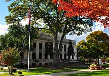
McNairy County is a county located in the U.S. state of Tennessee. As of the 2020 census, the population was 25,866. Its county seat and largest city is Selmer. McNairy County is located along Tennessee's border with the state of Mississippi.
Hardeman County is a county located in the U.S. state of Tennessee. As of the 2020 census, the population was 25,462. Its county seat is Bolivar.
Chester County is a county located in the U.S. state of Tennessee. As of the 2020 census, the population was 17,341. Its county seat is Henderson. The county was created in 1879 and organized in 1882. Chester County is included in the Jackson, TN Metropolitan Statistical Area.
Huntingdon is a town in Carroll County, Tennessee, United States. The population was 4,439 at the 2020 census and 3,985 in 2010. It is the county seat of Carroll County.
New Tazewell is a city in Claiborne County, Tennessee, United States. The population was 3,037 at the 2010 census.The population was 2,769 at the 2020 census.
Rossville is a town in Fayette County, Tennessee, United States. The population was 1,041 at the 2020 census, up from 664 at the 2010 census.
Crump is a city in Hardin County, Tennessee, United States. The population was 1,428 at the 2010 census, and 1,594 at the 2020 census.
Centerville is a town in Hickman County, Tennessee, United States. The population was 3,489 as of the 2020 Census. It is the county seat and the only incorporated town in Hickman County. It is best known for being the hometown of American comedian Minnie Pearl.
Eastview is a town in McNairy County, Tennessee. The population was 705 at the 2010 census.
Finger is a town in McNairy and Chester counties, Tennessee. The population was 350 at the 2000 census.
Guys is a town in McNairy County, Tennessee. The population was 466 at the 2010 census.
Michie is a town in McNairy County, Tennessee. The population was 647 at the 2000 census and 591 at the 2010 census.
Stantonville is a town in McNairy County, Tennessee. The population was 312 at the 2000 census and 283 at the 2010 census.
Gordonsville is a town in Smith County, Tennessee, United States. The population was 1,213 at the 2010 census.
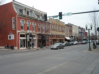
Franklin is a city in and the county seat of Williamson County, Tennessee, United States. About 21 miles (34 km) south of Nashville, it is one of the principal cities of the Nashville metropolitan area and Middle Tennessee. As of 2020, its population was 83,454. It is the seventh most populous city in Tennessee. Franklin is known to be the home of many celebrities, mostly country music stars.
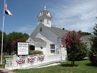
Weston is a town in Collin County, Texas, United States. The population was 563 at the 2010 census, and 283 at the 2020 census. As of 2023, Collin County estimates Weston's population at 1,050.
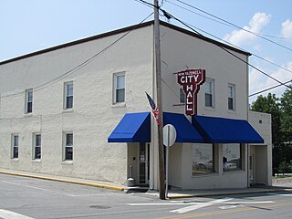
Enville is a town in Chester and McNairy counties, Tennessee, USA. The population was 230 at the 2000 census and 189 in 2010.
Milledgeville is a town in Chester, Hardin, and McNairy counties, Tennessee, United States. The population was 265 at the 2010 census.
Adamsville is a city in Hardin and McNairy counties, Tennessee, United States. The population was 2,207 at the 2010 census. Adamsville is named after George D. Adams, who operated an inn and stagecoach stop in the 1840s. Adamsville's nickname is the "Biggest Little Town in Tennessee" and was the home of Sheriff Buford Pusser.
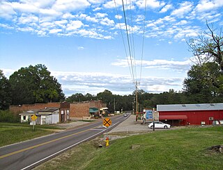
Purdy, Tennessee is a rural unincorporated community 3.5 mi (5.6 km) northeast of Selmer in McNairy County, Tennessee. Until 1890, Purdy was the county seat of McNairy County.