Huntsville, Tennessee

Last updated

Huntsville, Tennessee
Huntsville-courthouse-square-tn3.jpg
The courthouse square in Huntsville
Scott County Tennessee Incorporated and Unincorporated areas Huntsville Highlighted 4736640.svg
Location of Huntsville in Scott County, Tennessee.
Coordinates: 36°24′39″N84°29′42″W / 36.41083°N 84.49500°W / 36.41083; -84.49500
Country United States
State Tennessee
County Scott
Founded1850
Incorporated1965 [1]
Area
[2]
  Total8.30 sq mi (21.49 km2)
  Land8.30 sq mi (21.49 km2)
  Water0.00 sq mi (0.00 km2)
Elevation
[3]
1,319 ft (402 m)
Population
 (2020) [4]
  Total1,270
  Density153.03/sq mi (59.09/km2)
Time zone UTC-5 (Eastern (EST))
  Summer (DST) UTC-4 (EDT)
ZIP code
37756
Area code 423
FIPS code 47-36640 [5]
GNIS feature ID1288766 [3]
Website Town website

Huntsville is a town in Scott County, Tennessee, United States. The population was 1,270 at the 2020 census and 1,248 at the 2010 census. It is the county seat of Scott County. [6]

Contents

History

Huntsville was named after a long hunter known only by the surname "Hunt." This long hunter camped under a rock shelter in the mid-18th century and later moved his family to the area. When Scott County was formed in 1849, Huntsville was chosen as the county seat due to the site's central location within the new county as well as an excellent spring that flowed across the property. [7]

THC marker along TN-63 recalling the Independent State of Scott Huntsville-scott-sign-tn1.jpg
THC marker along TN-63 recalling the Independent State of Scott

During the U.S. Civil War, Scott County was staunchly pro-Union. In Tennessee's June 1861 referendum on secession, the county voted 541–19 against secession, the highest percentage of any county in Tennessee. In spite of fierce opposition from Scott and other East Tennessee counties, the ordinance passed and Tennessee seceded from the Union. Later that year, Scott County voted unanimously to secede from Tennessee and formed the Independent State of Scott. [8] [9]

In 1906, a new courthouse square was built in Huntsville using a beige-colored native sandstone for the buildings' outer walls. Although the courthouse burned in 1946, two of these sandstone buildings remain the First National Bank building and the Old Scott County Jail. [10] Both have been placed on the National Register of Historic Places.

The Baker family, which arrived in the Huntsville area shortly after the Civil War, has been active in state and national politics for several decades. James F. Baker (1864–1934) was a successful attorney and newspaper publisher. Baker's son, Howard H. Baker, Sr. (1902–1964), was the Republican candidate for governor of Tennessee in 1938 and later served in the U.S. House of Representatives. [11] Howard H. Baker, Jr. (1925-2014), son of Howard Sr., was elected to the U.S. Senate in 1966 and gained national attention as Vice Chairman of the Senate Watergate Committee in 1973. Baker later served as Senate Majority Leader (1981–1985) and White House Chief of Staff (1987–1988). [12]

Geography

Waterfall along Town Spring, a tributary of New River Huntsville-town-spring-waterfall-tn1.jpg
Waterfall along Town Spring, a tributary of New River

Huntsville is located at 36°24′39″N84°29′42″W / 36.41083°N 84.49500°W / 36.41083; -84.49500 (36.410732, -84.495124). [13] The town is situated atop the Cumberland Plateau at just over 10 miles (16 km) west of the plateau's eastern escarpment. Huntsville's southern boundary is located along a series of cliffs overlooking New River, approximately 15 miles (24 km) upstream from the river's mouth along the Big South Fork of the Cumberland River. Huntsville is surrounded by low mountains and hills that comprise the southern section of the Cumberland Mountains.

Huntsville's town center is situated along State Route 63 (SR 63, Howard Baker Highway), although the town's municipal boundaries stretch westward to SR 63's junction with U.S. Route 27 (US 27, Scott Highway). SR 63 intersects Interstate 75 (I-75) approximately 15 miles (24 km) east of Huntsville, near the base of the Cumberland Plateau.

According to the United States Census Bureau, the town has a total area of 3.3 square miles (8.5 km2), all of it land.

Demographics

Historical population
CensusPop.Note
1870 85
1880 11636.5%
1890 14928.4%
1970 337
1980 51954.0%
1990 66027.2%
2000 98148.6%
2010 1,24827.2%
2020 1,2701.8%
Sources: [14] [15] [4]

2020 census

Huntsville Racial Composition [16]
RaceNum.Perc.
White 1,23897.48%
Black or African American 40.31%
Native American 30.24%
Asian 50.39%
Other/Mixed 151.18%
Hispanic or Latino 50.39%

As of the 2020 United States Census, there were 1,270 people, 537 households, and 249 families residing in the town.

2000 census

As of the census [5] of 2000, there were 981 people, 406 households, and 259 families residing in the town. The population density was 295.3 inhabitants per square mile (114.0/km2). There were 441 housing units at an average density of 132.7 per square mile (51.2/km2). The racial makeup of the town was 96.94% White, 1.12% African American, 0.61% Native American, 0.10% Asian, and 1.22% from two or more races. Hispanic or Latino of any race were 0.31% of the population.

The First National Bank building in Huntsville, built in 1906. First-national-bank-scott-tn1.jpg
The First National Bank building in Huntsville, built in 1906.

There were 406 households, out of which 32.0% had children under the age of 18 living with them, 45.8% were married couples living together, 14.3% had a female householder with no husband present, and 36.0% were non-families. 33.0% of all households were made up of individuals, and 13.1% had someone living alone who was 65 years of age or older. The average household size was 2.31 and the average family size was 2.94.

In the town, the population was spread out, with 24.8% under the age of 18, 12.1% from 18 to 24, 28.4% from 25 to 44, 23.5% from 45 to 64, and 11.1% who were 65 years of age or older. The median age was 34 years. For every 100 females, there were 97.8 males. For every 100 females age 18 and over, there were 92.2 males.

The median income for a household in the town was $20,069, and the median income for a family was $25,804. Males had a median income of $26,902 versus $19,375 for females. The per capita income for the town was $16,469. About 17.2% of families and 24.1% of the population were below the poverty line, including 33.9% of those under age 18 and 16.4% of those age 65 or over.

Media

Notable people

Related Research Articles

<span class="mw-page-title-main">Putnam County, Tennessee</span> County in Tennessee, United States

Putnam County is a county located in the U.S. state of Tennessee. As of the 2020 census, the population was 79,854. Its county seat is Cookeville. Putnam County is part of the Cookeville, TN Micropolitan Statistical Area.

<span class="mw-page-title-main">Clay County, Tennessee</span> County in Tennessee, United States

Clay County is a county in the U.S. state of Tennessee. As of the 2020 census, the population was 7,581. Its county seat and only incorporated city is Celina. Clay County is named in honor of American statesman Henry Clay, member of the United States Senate from Kentucky and United States Secretary of State in the 19th century.

<span class="mw-page-title-main">Cumberland County, Virginia</span> County in Virginia, United States

Cumberland County is a county located in the Commonwealth of Virginia, United States. As of the 2020 census, the population was 9,675. Its county seat is Cumberland.

<span class="mw-page-title-main">White County, Tennessee</span> County in Tennessee, United States

White County is a county located in the U.S. state of Tennessee. As of the 2020 census, the population was 27,351. Its county seat is Sparta.

<span class="mw-page-title-main">Sumner County, Tennessee</span> County in Tennessee, United States

Sumner County is a county located on the central northern border of Tennessee in the United States. As of the 2020 United States Census, the population was 196,281. Its county seat is Gallatin, and its most populous city is Hendersonville. The county is named after an American Revolutionary War hero, General Jethro Sumner.

<span class="mw-page-title-main">Smith County, Tennessee</span> County in Tennessee, United States

Smith County is a county in the U.S. state of Tennessee. As of the 2020 census, the population was 19,904. Smith County is located in the region of the state known as Middle Tennessee. Its county seat is Carthage. The county was organized in 1799 and is named for Daniel Smith, a Revolutionary War veteran who made the first map of Tennessee and served as a United States senator.

<span class="mw-page-title-main">Scott County, Tennessee</span> County in Tennessee, United States

Scott County is a county located in the U.S. state of Tennessee. As of the 2020 census, its population was 22,039, down from 22,228 at the 2010 census. Its county seat is Huntsville and the largest town is Oneida. Scott County is known for having seceded from Tennessee in protest of the state's decision to join the Confederacy during the Civil War, and subsequently forming The Free and Independent State of Scott.

<span class="mw-page-title-main">Pickett County, Tennessee</span> County in Tennessee, United States

Pickett County is a county located in the U.S. state of Tennessee. As of the 2020 census, the population was 5,001, making it the least populous county in Tennessee. Its county seat is Byrdstown. The city of Byrdstown and the Kentucky town of Albany, 11 miles (18 km) to the northeast, are positioned between two Army Corps of Engineers lakes: Dale Hollow Lake, mainly in Tennessee, and Lake Cumberland, in Kentucky. The area is known as "Twin Lakes" and Byrdstown is noted as "The Gateway To Dale Hollow Lake". Every year thousands of people vacation at the many resorts situated along the lakes.

<span class="mw-page-title-main">Morgan County, Tennessee</span> County in Tennessee, United States

Morgan County is a county located in the U.S. state of Tennessee. As of the 2020 census, the population was 21,035. Its county seat is Wartburg. Morgan County is part of the Knoxville, TN Combined Statistical Area.

<span class="mw-page-title-main">Jackson County, Tennessee</span> County in Tennessee, United States

Jackson County is a county located in the U.S. state of Tennessee. The population was 11,617 at the 2020 census. Its county seat is Gainesboro. Jackson is part of the Cookeville Micropolitan Statistical Area.

<span class="mw-page-title-main">Hancock County, Tennessee</span> County in Tennessee, United States

Hancock County is a county located in the northeastern part of the U.S. state of Tennessee. As of the 2020 census, the population was 6,662, making it the fourth-least populous county in Tennessee. Its county seat is Sneedville.

<span class="mw-page-title-main">Paint Rock, Alabama</span> Town in Alabama, United States

Paint Rock is a town in Jackson County, Alabama, United States, along the Paint Rock River, and is included in the Huntsville-Decatur Combined Statistical Area. It was incorporated in July 1894.

<span class="mw-page-title-main">Woodville, Alabama</span> Town in Alabama, United States

Woodville is a town in Jackson County, Alabama, United States. It was officially established by an act of the Alabama State Legislature on December 13, 1819, one day before Alabama became a state. It was later incorporated on May 12, 1890, but lost its charter in 1897. It reincorporated in 1912. As of the 2010 census, the population of the town is 746, down from 761 in 2000.

<span class="mw-page-title-main">New Market, Alabama</span> Census-designated place in Alabama, United States

New Market is an unincorporated community and census-designated place (CDP) in Madison County, Alabama, United States, and is included in the Huntsville-Decatur Combined Statistical Area. As of the 2020 census, the population of the CDP was 1,543. Although it was the first area settled in Madison County, the town has never been incorporated.

<span class="mw-page-title-main">Tazewell, Tennessee</span> Town in Tennessee, United States

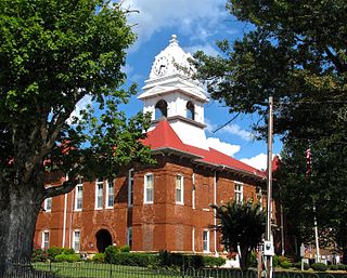
Tazewell is a town in and the county seat of Claiborne County, Tennessee, United States. The population was 2,165 at the 2000 census, 2,218 at the 2010 census, and 2,348 at the 2020 census. The town is named for Tazewell, Virginia, which itself was named for Henry Tazewell (1753–1799), a U.S. senator from Virginia.

<span class="mw-page-title-main">Sewanee, Tennessee</span> CDP in Tennessee, United States

Sewanee is a census-designated place (CDP) in Franklin County, Tennessee, United States. The population was 2,535 at the 2020 census. It is part of the Tullahoma, Tennessee Micropolitan Statistical Area.

<span class="mw-page-title-main">Sardis, Tennessee</span> Town in Tennessee, United States

Sardis is a town in Henderson County, Tennessee, United States. The population was 381 at the 2010 census.

<span class="mw-page-title-main">Sunbright, Tennessee</span> City in Tennessee, United States

Sunbright is a city in Morgan County, Tennessee, United States. The population was 519 at the 2020 census.

<span class="mw-page-title-main">Helenwood, Tennessee</span> Census-designated place in Tennessee, United States

Helenwood is an unincorporated community in Scott County, Tennessee, United States. The population was 846 at the 2000 census, when Helenwood was treated as an incorporated municipality. For the 2010 census, it was a census-designated place (CDP) with a population of 865.

<span class="mw-page-title-main">Carthage, Tennessee</span> Town in Tennessee, United States

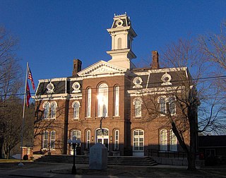
Carthage is a town in and the county seat of Smith County, Tennessee, United States; it is part of the Nashville Metropolitan Statistical Area. The population was 2,306 at the 2010 census. It is located on the Cumberland River, which was important to its early development. It is likely best known as the hometown of former Vice President and Senator Al Gore of the Democratic Party and his father, Senator Albert Gore, Sr. The younger Gore announced his 1988 and 2000 presidential bids, as well as his 1992 vice-presidential bid, from the steps of the Smith County Courthouse.

References

  1. Scott County: Our History Archived April 30, 2012, at the Wayback Machine . Retrieved: January 22, 2013.
  2. "ArcGIS REST Services Directory". United States Census Bureau. Retrieved October 15, 2022.
  3. 1 2 U.S. Geological Survey Geographic Names Information System: Huntsville, Tennessee
  4. 1 2 "Census Population API". United States Census Bureau. Retrieved October 15, 2022.
  5. 1 2 "U.S. Census website". United States Census Bureau . Retrieved January 31, 2008.
  6. "Find a County". National Association of Counties. Archived from the original on May 31, 2011. Retrieved June 7, 2011.
  7. Esther Sharp Sanderson, County Scott and Its Mountain Folk (Nashville, Tenn.: Blue & Gray Press, 1958), 4-11.
  8. Sanderson, 192.
  9. Information obtained from Tennessee Historical Commission marker in Huntsville, August 3, 2008.
  10. Sanderson, 6.
  11. Michael Rogers, "Howard H. Baker, Sr.." The Tennessee Encyclopedia of History and Culture, 2009. Retrieved: February 11, 2013.
  12. Michael Rogers, "Howard H. Baker, Jr.." The Tennessee Encyclopedia of History and Culture, 2009. Retrieved: February 11, 2013.
  13. "US Gazetteer files: 2010, 2000, and 1990". United States Census Bureau. February 12, 2011. Retrieved April 23, 2011.
  14. "Census of Population and Housing: Decennial Censuses". United States Census Bureau . Retrieved March 4, 2012.
  15. "Incorporated Places and Minor Civil Divisions Datasets: Subcounty Resident Population Estimates: April 1, 2010 to July 1, 2012". Population Estimates. U.S. Census Bureau. Archived from the original on June 11, 2013. Retrieved December 11, 2013.
  16. "Explore Census Data". data.census.gov. Retrieved December 7, 2021.