Mount Whitney is the highest mountain in the contiguous United States and the Sierra Nevada, with an elevation of 14,505 feet (4,421 m). It is in East–Central California, on the boundary between California's Inyo and Tulare counties, and 84.6 miles (136.2 km) west-northwest of North America's lowest point, Badwater Basin in Death Valley National Park, at 282 ft (86 m) below sea level. The mountain's west slope is in Sequoia National Park and the summit is the southern terminus of the John Muir Trail, which runs 211.9 mi (341.0 km) from Happy Isles in Yosemite Valley. The eastern slopes are in Inyo National Forest in Inyo County. Mount Whitney is ranked 18th by topographic isolation.

Grays Peak is the tenth-highest summit of the Rocky Mountains of North America and the U.S. state of Colorado. The prominent 14,278-foot (4352 m) fourteener is the highest summit of the Front Range and the highest point on the Continental Divide and the Continental Divide Trail in North America. Grays Peak is located in Arapahoe National Forest, 3.9 miles (6.2 km) southeast by east of Loveland Pass on the Continental Divide between Clear Creek and Summit counties. The peak is the highest point in both counties.

Mount Charleston, including Charleston Peak at 11,916 feet (3,632 m), is the highest mountain in both the Spring Mountains and Clark County, in Nevada, United States. It is the eighth-highest mountain in the state. Well separated from higher peaks by large, low basins, Charleston Peak is the most topographically prominent peak in Nevada, and the eighth-most-prominent peak in the contiguous United States. It is one of eight ultra-prominent peaks in Nevada. It is located about 35 miles (56 km) northwest of Las Vegas within the Mount Charleston Wilderness, which is within the Spring Mountains National Recreation Area of the Humboldt–Toiyabe National Forest.

White Mountain Peak, at 14,252 feet (4,344 m), is the highest peak in the White Mountains of California, the highest peak in Mono County, and the third highest peak in the state after Mount Whitney and Mount Williamson. In spite of its name, the summit block of the peak has large swaths of very dark and colorful orange scree and rock; it is composed of Mesozoic metavolcanic rock, which is igneous rock altered by rising granite.

Mount Nebo is the southernmost and highest mountain in the Wasatch Range of Utah, in the United States, and the centerpiece of the Mount Nebo Wilderness, inside the Uinta National Forest. It is named after the biblical Mount Nebo, overlooking Israel from the east of the Jordan River, which is said to be the place of Moses' death.

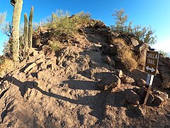
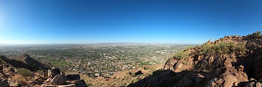
The Phoenix Mountains are a mountain range located in central Phoenix, Arizona. With the exception of Mummy Mountain, they are part of the Phoenix Mountain Preserve. They serve as a municipal park and offer hiking, mountain biking and equestrian trails at a variety of different access points.

La Plata Peak is the fifth-highest summit of the Rocky Mountains of North America and the U.S. state of Colorado. The prominent 14,343-foot (4,372 m) fourteener is located in the Collegiate Peaks Wilderness of San Isabel National Forest, 22.7 miles (36.5 km) northwest by west of the Town of Buena Vista in Chaffee County, Colorado, United States.

Capitol Peak is a high and prominent mountain summit in the Elk Mountains range of the Rocky Mountains of North America. It is the 52nd highest mountain in North America. The 14,137-foot (4,309 m) fourteener is located in the Maroon Bells-Snowmass Wilderness of White River National Forest, 8.7 miles (14.0 km) east by south of the community of Redstone in Pitkin County, Colorado, United States.

Algonquin Peak is a mountain in the MacIntyre Range of the Adirondacks in the U.S. state of New York. It is the second highest mountain in New York, with an elevation of 5,114 feet (1,559 m), and one of the 46 Adirondack High Peaks. It is located in the town of North Elba in Essex County and in the High Peaks Wilderness Area of Adirondack Park. The first recorded ascent of the mountain was made on August 8, 1837, by a party led by New York state geologist Ebenezer Emmons. It was originally named Mount McIntyre, after Archibald McIntyre, but this name was eventually applied to the entire range. Surveyor Verplanck Colvin added the name "Algonquin" in 1880. This name came from the peak reputedly being on the Algonquian side of a nearby informal boundary between the Algonquian and their Iroquois neighbors, although no such boundary existed in reality.

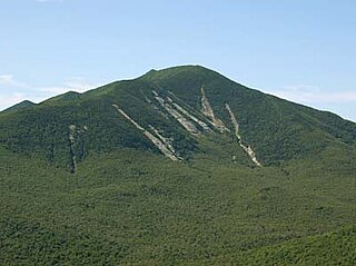
Camel's Hump is a mountain in the Green Mountains in the U.S. state of Vermont. The north slope of the mountain borders the Winooski River, which has carved through the Green Mountains over eons. At 4,083 ft (1,244 m), it is tied with Mount Ellen for the third-highest mountain in Vermont. Surmounted by 10 acres (4 ha) of alpine tundra, the mountain is the most significant feature in Camel's Hump State Park. Because of its distinctive profile, it is perhaps the state's most recognized mountain, featured on the state quarter.
Dix Mountain is a mountain in the Dix Range of the Adirondacks in the U.S. state of New York. With an elevation of 4,857 feet (1,480 m), it is the sixth highest peak in New York and one of the 46 Adirondack High Peaks. It is located roughly on the boundary between the towns of North Hudson and Keene in Essex County, and in the High Peaks Wilderness Area of Adirondack Park. The crest of the peak consists of a very narrow ridge, which continues to the southeast and rises to a subsidiary peak named Beckhorn, then continues south to other peaks of the Dix Range. The summit is also in an alpine zone above the treeline. The ridge offers unobstructed views of Elk Lake to the southwest, the Great Range to the northwest, and Lake Champlain and the Green Mountains to the east.

Mount Moosilauke is a 4,802-foot-high (1,464 m) mountain at the southwestern end of the White Mountains in the town of Benton, New Hampshire, United States. It is the tenth highest and most southwesterly of the 4,000 foot summits in the White Mountains.

Hole in the Mountain Peak is the highest mountain in the East Humboldt Range in Elko County, Nevada, United States. It is the thirty-fifth highest mountain in the state, and also ranks as the eleventh-most topographically prominent peak in the state. It is located within the East Humboldt Wilderness of the Humboldt–Toiyabe National Forest and is 11,311 feet (3,448 m) high. The peak is 35 miles (56 km) east of Elko and 14 miles (23 km) southwest of Wells, making it a rather prominent feature of the drive along Interstate 80 in Elko County. The U.S. Board on Geographic Names lists two variant names, Mount Bonpland and Mount Bonplant.

Piestewa Peak, at 2,610 feet (796 m) is the second highest point in the Phoenix Mountains, after Camelback Mountain, and the third highest in the city of Phoenix, Arizona. It is located in the Piestewa Peak Recreation Area within the Phoenix Mountain Preserve, near Piestewa Freeway. Piestewa Peak is named in honor of Army Spc. Lori Ann Piestewa, the first known Native American woman to die in combat in the U.S. military, and the first female soldier to be killed in action in the 2003 Iraq War.

Mount Yale is a high and prominent mountain summit of the Collegiate Peaks in the Sawatch Range of the Rocky Mountains of North America. The 14,200-foot (4328.2 m) fourteener is located in the Collegiate Peaks Wilderness of San Isabel National Forest, 9.4 miles (15.2 km) west by north of Buena Vista, Colorado. The mountain was named in honor of Elihu Yale, the primary benefactor of what is now Yale University.

Lone Peak is a mountain summit in the Wasatch Range southeast of Salt Lake City, Utah, United States, and the center of the Lone Peak Wilderness, established in 1978. With an elevation of 11,260 feet (3,430 m), it is one of the highest peaks in the range and among the most prominent of the Wasatch Front, towering over the Salt Lake City suburb of Draper and easily visible from most of the valley, which makes it a popular destination for hiking and rock climbing.

The Pfeifferhorn is the 11,331 feet (3,454 m) triangularly-shaped peak located in the most isolated part of the Lone Peak Wilderness Area of the Wasatch Mountains in northern Utah, United States. This rugged Utah mountain, commonly referred to as the Little Matterhorn, is the fifth-highest peak in the Wasatch Range. The summit can be reached by hiking, though some scrambling is required. There are several technical rock climbing routes with the north ridge being the most popular. This summit also makes an excellent winter mountaineering adventure.

Deseret Peak is the highest peak in the Stansbury Mountains with an elevation of 11,035 ft. It is located in the Deseret Peak Wilderness area west of Grantsville, Utah and east of Skull Valley Indian Reservation. It is the fourth most topographically prominent peak in the state of Utah. The site is a popular destination for hikers and backcountry skiers as the area is a contrast of the alpine wilderness with the surrounding desert basin. The trail that leads to the peak is easily accessible from Salt Lake City. The mountain offers views of the Bonneville Salt Flats, the Great Salt Lake, and the surrounding towns and mountain ranges. On a clear day, it is possible to see Mount Nebo, the highest peak in the adjacent Wasatch Mountains.

Giant Mountain, also known as Giant of the Valley, is a mountain in the Adirondacks in the U.S. state of New York. It is the twelfth-highest peak in New York, with an elevation of 4,627 feet (1,410 m), and one of the 46 High Peaks in Adirondack Park. It is located in the Giant Mountain Wilderness Area, in the town of Keene in Essex County. The mountain is named for its towering appearance from the nearby Pleasant Valley to the east, which sits at a low elevation.

Mount Baldy is an extinct stratovolcano in eastern Arizona in the United States. With a summit elevation of 11,409 feet (3,477 m), the peak of Mount Baldy rises above the tree line and is left largely bare of vegetation, lending the mountain its current name. The Mount Baldy Wilderness occupies the eastern slope of the mountain and is managed by the Apache-Sitgreaves National Forest.