Related Research Articles

The Sonoran Desert is a North American desert and ecoregion that covers large parts of the southwestern United States, as well as the northwestern Mexican states of Sonora, Baja California, and Baja California Sur. Despite being the hottest desert in both Mexico and the United States, it's the most biologically diverse desert in the world. It has an area of 260,000 square kilometers (100,000 sq mi).

The Tonto National Forest, encompassing 2,873,200 acres, is the largest of the six national forests in Arizona and is the ninth largest national forest in the United States. The forest has diverse scenery, with elevations ranging from 1,400 feet in the Sonoran Desert to 7,400 feet in the ponderosa pine forests of the Mogollon Rim. The Tonto National Forest is also the most visited "urban" forest in the United States.

Tonto National Monument is a National Monument in the Superstition Mountains, in Gila County of central Arizona. The area lies on the northeastern edge of the Sonoran Desert ecoregion, an arid habitat with annual rainfall of about 16 inches (400 mm). The Salt River runs through this area, providing a rare, year-round source of water.

The Tucson Mountains are a minor mountain range west of Tucson, Arizona. The Tucson Mountains, including Wasson Peak, are one of four notable mountain ranges surrounding the Tucson Basin. The Santa Catalina Mountains lie to the northeast, the Rincon Mountains are to the east of Tucson, and the Santa Rita Mountains lie to the south. Additionally the Sierrita Mountains lie due south, the Roskruge Mountains lie to the west across Avra Valley, the Silver Bell Mountains lie to the northwest, and the Tortolita Mountains lie to the north across the Santa Cruz Valley.

The Sierra Ancha is a mountain range in Gila County, in central Arizona. It lies between Roosevelt Lake to the south, the Tonto Basin to the west, Cherry Creek to the east, and Pleasant Valley to the north. The range is one of several, including the Bradshaw Mountains, Mingus Mountain of the Black Hills, and the Mazatzal Mountains, which form a transitional zone between the lowland deserts of southern Arizona and the Colorado Plateau of northeastern Arizona. The highest point in the range is Aztec Peak, at an elevation of 2345 m (7694 ft).

Piestewa Peak, at 2,610 feet (796 m) is the second highest point in the Phoenix Mountains, after Camelback Mountain, and the third highest in the city of Phoenix, Arizona. It is located in the Piestewa Peak Recreation Area within the Phoenix Mountain Preserve, near Piestewa Freeway. Piestewa Peak is named in honor of Army Spc. Lori Ann Piestewa, the first known Native American woman to die in combat in the U.S. military, and the first female soldier to be killed in action in the 2003 Iraq War.

The following is an alphabetical list of articles related to the U.S. state of Arizona.

Parkinsonia microphylla, the yellow paloverde, foothill paloverde or little-leaved palo verde; syn. Cercidium microphyllum), is a species of palo verde.

A nurse tree is a larger, faster-growing tree that shelters a smaller, slower-growing tree or plant. The nurse tree can provide shade, shelter from wind, or protection from animals who would feed on the smaller plant.
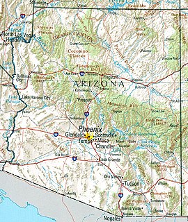
Arizona is a landlocked state situated in the southwestern region of the United States of America. It has a vast and diverse geography famous for its deep canyons, high- and low-elevation deserts, numerous natural rock formations, and volcanic mountain ranges. Arizona shares land borders with Utah to the north, the Mexican state of Sonora to the south, New Mexico to the east, and Nevada to the northwest, as well as water borders with California and the Mexican state of Baja California to the southwest along the Colorado River. Arizona is also one of the Four Corners states and is diagonally adjacent to Colorado.
Saguaro National Park is an American national park in Pima County, southeastern Arizona. The 92,000-acre (37,000 ha) park consists of two separate areas—the Tucson Mountain District (TMD) about 10 miles (16 km) west of the city of Tucson and the Rincon Mountain District (RMD) about 10 miles (16 km) east of the city—that preserve Sonoran Desert landscapes, fauna, and flora, including the giant saguaro cactus.

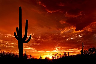
The saguaro is a tree-like cactus species in the monotypic genus Carnegiea that can grow to be over 12 meters tall. It is native to the Sonoran Desert in Arizona, the Mexican state of Sonora, and the Whipple Mountains and Imperial County areas of California. The saguaro blossom is the state wildflower of Arizona. Its scientific name is given in honor of Andrew Carnegie. In 1994, Saguaro National Park, near Tucson, Arizona, was designated to help protect this species and its habitat.

The Bill Williams River National Wildlife Refuge protects the lower course of the Bill Williams River, to its mouth at Lake Havasu reservoir, in western Arizona. It is located within eastern La Paz and Mohave Counties, in the Lower Colorado River Valley region.
The Whipple Mountains Wilderness is a 76,122-acre (30,805 ha) wilderness administered by the Bureau of Land Management (BLM). Most of the Whipple Mountains are within the wilderness area. It is located in the northeastern Colorado Desert near the Colorado River. Lake Havasu and Lake Havasu City are 25 miles (40 km) to the North. Earp, California and Parker, Arizona are 20 miles (32 km) to the South. The Parker Dam is 8 miles (13 km) due east.
Marginitermes hubbardi, commonly known as the light western drywood termite, is a species of termite in the family Kalotermitidae. It is found in Central America and desert regions of southwestern North America.

San Tan Mountain Regional Park is a large rural/suburban park located in Pinal County. Although the park is administered by Maricopa County Parks, it is located within Pinal County. It encompasses over 10,000 acres and preserves a portion of the San Tan Mountains, south of Queen Creek.

Nurse plants are trees that serve as protection to smaller plants. Xeric environments can experience extreme high temperatures and extreme low temperatures. In these environments, nurse plants provide shaded microhabitats for the survival of several other plant species. In the Sonoran Desert, nurse plants canopies provide reduced summer daytime temperatures, soil surface temperatures, and direct sunlight, higher soil fertility, protection from the wind and browsing animals, reduced evapotranspiration rates in the nursed species, elevated nighttime temperatures, and post-fire resprouting in some species... This means that nurse plants provide a positive interaction between itself and the organisms in which it protects, and are often crucial in maintaining biodiversity in water-scarce environments.
Signal Mountain Wilderness is a protected wilderness area centered around its namesake Signal Mountain, rising 1,200 feet (370 m) to a summit at 2,057 feet (627 m) in the Gila Bend Mountains in the U.S. state of Arizona. Established in 1990 under the Arizona Desert Wilderness Act, the area is managed by the Bureau of Land Management. The desert wilderness is made up of steep canyons, winding arroyos, and volcanic peaks within a Sonoran Desert ecosystem.
Table Top Wilderness is a protected wilderness area centered around its namesake Table Top Mountain, a summit of 4,373 feet in the Table Top Mountains in the U.S. state of Arizona. Established in 1990 under the Arizona Desert Wilderness Act the area is managed by the Bureau of Land Management. It is located in the Sonoran Desert National Monument south of Interstate 8 between the towns of Casa Grande and Gila Bend. The flat-topped mesa rises from the desert floor in Vekol Valley to the east surrounded by smaller canyons and desert washes with views of the desert plain in all directions. There are two established trails in the wilderness area, one of which leads to the summit.
Tres Alamos Wilderness is a protected wilderness area centered around the southern portion of the Black Mountains and the range high point of Sawyer Peak in the U.S. state of Arizona. The namesake feature, Tres Alamos, is a prominent and colorful monolith in the mountains. Established in 1990 under the Arizona Desert Wilderness Act the area is managed by the Bureau of Land Management.
References
- ↑ "The Goldfield Mountains: Trail Riding in Goldfield, Arizona". The Trail Rider. Retrieved 15 March 2013.
- ↑ "Goldfield Mountains - Apache Junction - Arizona". Arizonensis. Retrieved 13 March 2013.
- ↑ "Introducing the Goldfield Mountains". mile204.us. Retrieved 12 March 2013.
- ↑ "Introducing the Goldfield Mountains". mile204.us. Retrieved 12 March 2013.