Caneadea, New York

Last updated

Caneadea, New York
USA New York location map.svg
Red pog.svg
Caneadea
Location within the state of New York
Coordinates: 42°24′1″N78°9′36″W / 42.40028°N 78.16000°W / 42.40028; -78.16000
Country United States
State New York
County Allegany
Government
  Type Town Council
   Town Supervisor Michel A. Cox
   Town Council
Members' List
Area
[1]
  Total36.34 sq mi (94.13 km2)
  Land35.65 sq mi (92.33 km2)
  Water0.69 sq mi (1.80 km2)
Elevation
1,467 ft (447 m)
Population
 (2020) [2]
  Total2,238 Decrease2.svg
  Estimate 
(2021) [2]
2,226
  Density65.78/sq mi (25.40/km2)
Time zone UTC-5 (Eastern (EST))
  Summer (DST) UTC-4 (EDT)
ZIP code
14717
Area code 585
FIPS code 36-003-12243
GNIS feature ID0978787
Website townofcaneadea.org

Caneadea is a township in Allegany County, New York, United States. It includes the hamlets Caneadea, Houghton, and Oramel. [3]

Contents

History

The name Caneadea reportedly originates from a Seneca phrase meaning "where the heavens rest upon the earth". Following the American war for independence in which the Seneca aligned with the British, the majority of Seneca territory in western New York was ceded to the new American government with the exception of some small areas of land. One such area was a strip eight miles long and two miles wide in the Genesee River Valley that became known as the Caneadea Reservation.

The land of the reservation included much of the modern day township. Within the reservation was a small native village located on a bluff above the river. The village contained what is known as the Council House, which many years later was transported to what is now Letchworth State Park and renovated. Moses van Campen reportedly ran the "gauntlet" outside the Council House in 1782 while a captive of the Senecas during the American war for independence. The Caneadea Reservation's existence ended in 1826 after the Seneca sold the land to speculators.

The Caneadea township was officially formed in 1806, but included large portions of land that are no longer part of it. During the 1800s, much of the forested land was converted to farmland, including highly fertile land near the river.

Caneadea contained a route of the underground railroad, helping individuals escape slavery from the south. The Civil War's need for soldiers took a heavy human toll on the town.

Starting in 1851, the Genesee Valley Canal passed through Caneadea. While overall the canal was massively unprofitable for the state of New York, it did contribute significantly to the culture and economy of Caneadea and its hamlets Houghton and Oramel. Many businesses sprung up catering to canal traffic. Oramel became especially prosperous. Houghton was popular for horse racing and reportedly quite rowdy. New York finally decommissioned the boondoggle canal in 1878. In 1882 railroad tracks replaced much of the canal's old towpath. Trains stopped traveling through Caneadea in 1969, and the tracks removed in 1977. Today, much of the old railroad bed pathway is part of a recreational pathway.

In 1883, a seminary that was to eventually become today's Houghton University was founded by a farmer. The seminary eventually formed into a college that became accredited in 1923. Houghton changed dramatically from a wild canal port commonly known as Jockey Street (due to popular horse racing) into a more tranquil community strongly associated with the college and its sponsoring Wesleyan denomination. [4]

In the late 1980s, a New York State committee was formed to find potential nuclear waste disposal sites. Caneadea, along with some other towns in Allegany County, was proposed as a potential site.There was significant disapproval by many area residents over this, and organizers committed to fight the state legally, politically and with civil disobedience. In 1990, protestors prevented the proposed site in Caneadea from being accessed by individuals from the siting commission. On January 16, protestors used their bodies and farm equipment to block roads. State police made eight arrests, but the site was still not accessed. On April 5, a larger effort was made to access the site and was met by a larger resistance. Six elderly individuals chained themselves to a bridge, resulting in their arrests and the chain being cut by state police. Farm equipment was again used for road blocking. Large amounts of protestors blocked the road and wore paper masks to hide help their identities. Horse riders blocking the road frustrated state police and played a major role in finally thwarting the unsuccessful attempt to access the site. Shortly after the second failed attempt in Caneadea, the governor of New York ordered the siting commission to discontinue its attempts to assess sites in Allegany County. [5]

A significant event occurred in 1995 when a massive cannabis raid at a farm along Caneadea's main road discovered an estimated $100,000 (not adjusted for inflation) worth of the substance hidden in various areas including cornfields, hay bales, and a pigpen. Over 100 plants and about 50 pounds of harvested cannabis were reportedly seized. [6]

Geography

According to the United States Census Bureau, the town has a total area of 36.3 square miles (94.1 km2), of which 35.6 square miles (92.3 km2) is land and 0.69 square miles (1.8 km2), or 1.91%, is water. [7]

The town developed along the Genesee River, an important and historic Western New York river, which had also been valued by the Seneca. Rushford Lake is partly at the town's west line, and Caneadea Creek is an important stream in the town.

New York State Route 19 passes through the town (north-south) and intersects New York State Route 243 north of Canaeadea village.

Demographics

Historical population
CensusPop.Note
1820 696
1830 78212.4%
1840 1,633108.8%
1850 1,477−9.6%
1860 2,12543.9%
1870 1,869−12.0%
1880 1,764−5.6%
1890 1,639−7.1%
1900 1,310−20.1%
1910 1,3543.4%
1920 1,183−12.6%
1930 1,066−9.9%
1940 1,0892.2%
1950 1,84569.4%
1960 1,9113.6%
1970 2,36423.7%
1980 2,4212.4%
1990 2,5515.4%
2000 2,6945.6%
2010 2,542−5.6%
2020 2,238−12.0%
2021 (est.)2,226 [2] −0.5%
U.S. Decennial Census [8]

As of the census [9] of 2000, there were 2,694 people, 650 households, and 436 families residing in the town. The population density was 75.8 inhabitants per square mile (29.3/km2). There were 1,098 housing units at an average density of 30.9 per square mile (11.9/km2). The racial makeup of the town was 96.33% White, 1.00% African American, 0.15% Native American, 0.97% Asian, 0.56% from other races, and 1.00% from two or more races. Hispanic or Latino of any race were 2.26% of the population.

There were 650 households, out of which 33.7% had children under the age of 18 living with them, 56.5% were married couples living together, 7.1% had a female householder with no husband present, and 32.9% were non-families. 25.2% of all households were made up of individuals, and 8.3% had someone living alone who was 65 years of age or older. The average household size was 2.72 and the average family size was 3.20.

In the town, the population was spread out, with 18.4% under the age of 18, 40.9% from 18 to 24, 16.1% from 25 to 44, 13.4% from 45 to 64, and 11.1% who were 65 years of age or older. The median age was 22 years. For every 100 females, there were 80.9 males. For every 100 females age 18 and over, there were 75.5 males.

The median income for a household in the town was $31,065, and the median income for a family was $39,667. Males had a median income of $29,643 versus $21,563 for females. The per capita income for the town was $10,010. About 12.7% of families and 21.3% of the population were below the poverty line, including 19.8% of those under age 18 and 1.0% of those age 65 or over.

Notable people

Communities and locations in Caneadea

Related Research Articles

<span class="mw-page-title-main">Allegany County, New York</span> County in New York, United States

Allegany County is a county in the U.S. state of New York. As of the 2020 census, the population was 46,456. Its county seat is Belmont. Its name derives from a Lenape word, applied by European-American settlers of Western New York State to a trail that followed the Allegheny River; they also named the county after this. The county is part of the Western New York region of the state.

<span class="mw-page-title-main">Livingston County, New York</span> County in New York, United States

Livingston County is a county in the U.S. state of New York. As of the 2020 census, the population was 61,834. Its county seat is Geneseo. The county is named after Robert R. Livingston, who helped draft the Declaration of Independence and negotiated the Louisiana Purchase. The county is part of the Finger Lakes region of the state.

<span class="mw-page-title-main">Belfast, New York</span> Town in New York, United States

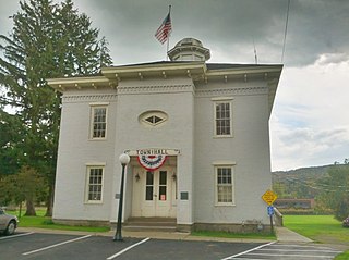
Belfast is a town in Allegany County, New York, United States. The town is in what is called the Southern Tier of the state. Its population was 1,656 at the 2020 census. It was named in 1825 after the city of Belfast, Ireland, because it had numerous residents of Scots-Irish ancestry from that area.

Genesee is a town in Allegany County, New York, United States. The population was 1,653 at the 2020 census. Genesee is in the southwestern corner of the county, southeast of Olean.

Houghton is a hamlet located in the Town of Caneadea in Allegany County, western New York, United States. The population was 1,693 at the 2010 census.

Independence is a town in Allegany County, New York, United States. The population was 1,095 at the 2020 census. The town is in the southeast corner of Allegany County, southeast of the village of Wellsville.

<span class="mw-page-title-main">Rushford, New York</span> Town in New York, United States

Rushford is a town in Allegany County, New York, United States. The population was 1,085 at the 2020 census. Rushford is in the northwest part of Allegany County and is northeast of Olean.

Willing is a town in Allegany County, New York, United States. The population was 1,295 at the 2020 census. The town is on the southern border of the county, south of the village of Wellsville.

<span class="mw-page-title-main">Carrollton, New York</span> Town in New York, United States

Carrollton is a town in Cattaraugus County, New York, United States. The population was 1,214 at the 2020 census. The town was named after Guy Carrollton Irvine, an early settler of the region.

Coldspring is a town in Cattaraugus County, New York, United States. As of the 2020 census it had a population of 661. It is located in the southwest part of the county, west of the city of Salamanca.

<span class="mw-page-title-main">Ischua, New York</span> Town in New York, United States

IschuaISH-way is a town in Cattaraugus County, New York, United States. The population was 736 at the 2020 census. Ischua is also the name of a hamlet in the town. The town is on the eastern border of the county, north of Olean.

Red House is a town in Cattaraugus County, New York, United States. As of the 2020 census, the town population was 30, making it the least populous town in the state. The town is on the south edge of Cattaraugus County, south of the city of Salamanca.

South Valley is a town in Cattaraugus County, New York, United States. The population was 250 at the 2020 census. The name is derived from the town's geographical attributes.

<span class="mw-page-title-main">Montezuma, New York</span> Town in New York, United States

Montezuma is a town in Cayuga County, New York, United States. The population was 1,277 at the 2010 census.

<span class="mw-page-title-main">Lysander, New York</span> Town in New York, United States

Lysander is a town in Onondaga County, New York, United States. As of the 2020 Census, the population was 23,074. The town was named after Lysander, a Spartan military leader, by a clerk interested in the classics. Lying to the northwest of Syracuse, much of the town is suburban in character.

<span class="mw-page-title-main">Cuba, New York</span> Town in New York, United States

Cuba is a town on the western border of Allegany County, New York, United States. The village of Cuba lies within its borders. The federally recognized tribe of Seneca Native Americans has a reservation on the western town line. As of the 2020 Census, the total population was 3,154.

Friendship is a town in Allegany County, New York, United States. The population was 1,960 at the 2020 census. The town's name was adopted to mark the resolution of earlier conflicts.

Salamanca is a town in Cattaraugus County, New York, United States. The population was 470 at the 2020 census. The name is from José de Salamanca y Mayol, Marquis of Salamanca, a major Spanish investor in the Atlantic and Great Western Railroad, a local railroad.

Nunda is a town in Livingston County, New York, United States. The population was 3,064 at the 2010 census. Nunda welcomes visitors with signs stating "Welcome to Nunda, a Nice Place to Live." The name is derived from Nunda-wa-ono, the name given to it by a group of the Seneca people who once lived in the hills and valleys along the Genesee River and Keshequa Creek within the present-day town. In the Seneca language, "Nunda" relates to hills, and a popular translation is "Where the valley meets the hills".

Portage is a town in the southwest corner of Livingston County, New York, United States. The town is at the south end of Letchworth State Park. The name of the town stems from the need to portage (carry) canoes around the falls of the Genesee River. The population of Portage was 884 at the 2010 census.

References

  1. "2016 U.S. Gazetteer Files". United States Census Bureau. Retrieved July 4, 2017.
  2. 1 2 3 Bureau, US Census. "City and Town Population Totals: 2020—2021". Census.gov. US Census Bureau. Retrieved September 7, 2022.
  3. "Caneadea". www.alleganyhistory.org. Retrieved March 14, 2024.
  4. "Caneadea Here and There".
  5. "Allegany County resists nuclear dumping, 1989-1990 | Global Nonviolent Action Database". nvdatabase.swarthmore.edu. Retrieved March 14, 2024.
  6. Staff (September 9, 1995). "$100,000 WORTH OF POT FOUND". Buffalo News. Retrieved March 14, 2024.
  7. "Geographic Identifiers: 2010 Demographic Profile Data (G001): Caneadea town, Allegany County, New York". U.S. Census Bureau, American Factfinder. Archived from the original on February 12, 2020. Retrieved October 24, 2014.
  8. "Census of Population and Housing". Census.gov. Retrieved June 4, 2015.
  9. "U.S. Census website". United States Census Bureau . Retrieved January 31, 2008.

42°23′11″N78°09′13″W / 42.38639°N 78.15361°W / 42.38639; -78.15361