Almond (village), New York

Last updated

Almond, New York
USA New York location map.svg
Red pog.svg
Almond
Location within the state of New York
Usa edcp location map.svg
Red pog.svg
Almond
Almond (the United States)
North America laea location map.svg
Red pog.svg
Almond
Almond (North America)
Coordinates: 42°19′14″N77°44′19″W / 42.32056°N 77.73861°W / 42.32056; -77.73861
Country United States
State New York
Counties Allegany, Steuben
Towns Almond, Hornellsville
Government
  TypeVillage Board
  MayorJohn Meehan
Area
[1]
  Total0.56 sq mi (1.46 km2)
  Land0.56 sq mi (1.46 km2)
  Water0.00 sq mi (0.00 km2)
Elevation
1,335 ft (407 m)
Population
 (2020)
  Total415
  Density735.82/sq mi (283.93/km2)
Time zone UTC-5 (Eastern (EST))
  Summer (DST) UTC-4 (EDT)
ZIP code
14804
Area code 607
FIPS code 36-01440
GNIS feature ID0942389
Website almondny.com

Almond is a village located partially in the town of Almond in Allegany County, and partially in the town of Hornellsville in Steuben County, New York, United States. The population was 466 at the 2010 census. [2]

Contents

History

The first people to settle in the Karr Valley area came from Luzerne County, Pennsylvania in 1796. [3] After the legal formation of Allegany County, New York in 1806, the area that would become Almond was initially a part of the town of Alfred, New York. In 1821, Almond was separated from Alfred by an "act of Legislature." [4] [5]

Notably, the area was not named after the almond tree nut, but rather after the Almond River near Edinburgh, Scotland, from where its settlers came. The village's residents pronounce the town's name with the Scottish pronunciation, which is closer to "Ellmund". [4] [6]

In the early 1800s, Almond "thrived... with many mills and factories popping up along the narrow creek and Main Street." [6] However, the town's economic growth was limited by the size of the narrow valley it inhabited, and was reportedly "maxed out" in the 1840s. As a result, new businesses opted to move into neighboring towns like Hornell. By the early 1900s, the town's economy had stagnated significantly; old factories burned down and owners opted to rebuild in other locations, rather than in Almond. [6]

Geography

According to the United States Census Bureau, the village has a total area of 0.6 square mile (1.5 km2), all land. [2]

Canacadea Creek flows through the village. The Southern Tier Expressway (Interstate 86 and New York State Route 17) and New York State Route 21 pass through the village.

Demographics

Historical population
CensusPop.Note
1930 438
1940 53321.7%
1950 65923.6%
1960 6965.6%
1970 658−5.5%
1980 568−13.7%
1990 458−19.4%
2000 4610.7%
2010 4661.1%
2020 415−10.9%
U.S. Decennial Census [7]

As of the census [8] of 2000, there were 461 people, 194 households, and 117 families residing in the village. The population density was 816.3 inhabitants per square mile (315.2/km2). There were 214 housing units at an average density of 378.9 per square mile (146.3/km2). The racial makeup of the village was 97.83% White, 0.87% Asian, 0.87% from other races, and 0.43% from two or more races. Hispanic or Latino of any race were 0.87% of the population.

There were 194 households, out of which 28.4% had children under the age of 18 living with them, 46.4% were married couples living together, 11.9% had a female householder with no husband present, and 39.2% were non-families. 34.5% of all households were made up of individuals, and 11.9% had someone living alone who was 65 years of age or older. The average household size was 2.38 and the average family size was 3.09.

In the village, the population was spread out, with 26.9% under the age of 18, 8.5% from 18 to 24, 27.3% from 25 to 44, 24.9% from 45 to 64, and 12.4% who were 65 years of age or older. The median age was 36 years. For every 100 females, there were 88.2 males. For every 100 females age 18 and over, there were 88.3 males.

The median income for a household in the village was $31,000, and the median income for a family was $42,000. Males had a median income of $35,714 versus $21,563 for females. The per capita income for the village was $18,509. About 11.5% of families and 16.6% of the population were below the poverty line, including 27.3% of those under age 18 and 8.2% of those age 65 or over.

Notable person

Related Research Articles

<span class="mw-page-title-main">Allegany County, New York</span> County in New York, United States

Allegany County is a county in the Southern Tier of the U.S. state of New York. As of the 2020 census, the population was 46,456. Its county seat is Belmont. Its name derives from a Lenape word, applied by European-American settlers of Western New York State to a trail that followed the Allegheny River; they also named the county after this.

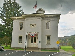
Belmont is a village within the town of Amity in Allegany County, New York, United States. Belmont is the county seat of Allegany County. The population was 969 at the 2010 census. The name means "beautiful hill". The village is centrally located in Amity and is northeast of Olean.

Birdsall is a town in Allegany County, New York, United States. The population was 221 at the 2010 census. The town is named after John Birdsall, a circuit judge. Birdsall is in the northeast part of Allegany County.

Burns is a town in Allegany County, New York, United States. The population was 1,045 at the 2020 census. The town is named after Scots poet Robert Burns.

<span class="mw-page-title-main">Canaseraga, New York</span> Village in New York, United States

Canaseraga is a village in Allegany County, New York, United States. The population was 550 at the 2010 census. The name is derived from a creek that flows past the village, which is reportedly a Seneca term for "lying among milkweeds" or "slippery elms".

Caneadea is a town in Allegany County, New York, United States. The population was 2,238 at the 2020 census.

West Almond is a town in Allegany County, New York, United States. The population was 280 at the 2020 census. West Almond is centrally located in the eastern part of the county and is west of Hornell.

<span class="mw-page-title-main">Carrollton, New York</span> Town in New York, United States

Carrollton is a town in Cattaraugus County, New York, United States. The population was 1,214 at the 2020 census. The town was named after Guy Carrollton Irvine, an early settler of the region.

Freedom is a town in Cattaraugus County, New York, United States. The population was 2,244 at the 2021 census. The town is in the northeast corner of Cattaraugus County.

St. Bonaventure is a hamlet and census-designated place (CDP) in the town of Allegany in Cattaraugus County, New York, United States. The population was 1,963 at the 2020 census.

<span class="mw-page-title-main">Hartsville, New York</span> Town in New York, United States

Hartsville is a town in Steuben County, New York, United States. The population was 561 at the 2020 census. The town is named after a prominent early settler, Reuben Hart.

Hornellsville is a town in Steuben County, New York, United States. The population, not counting the city of Hornell, was 4,039 at the 2020 census. The name is taken from a prominent pioneer family.

<span class="mw-page-title-main">Almond, New York</span> Town in New York, United States

Almond is a town in Allegany County, New York, United States. The population was 1,526 at the 2020 census.

Andover is a town in Allegany County, New York, United States. The population was 1,634 at the 2020 census. The town is on the eastern edge of Allegany County and contains the village of Andover.

Angelica is a village in the town of Angelica in Allegany County, New York, United States. The population was 869 at the 2010 census. The village and the town are named after Angelica Schuyler Church, a daughter of General Philip Schuyler, sister-in-law of Founding Father Alexander Hamilton and wife of John Barker Church.

Angelica is a town in the middle of Allegany County, New York, United States. The population was 1,284 at the 2020 census. The town is named after Angelica Schuyler Church, the sister of Elizabeth Schuyler Hamilton, activist, scholar, devoted sister and mother, daughter of General Philip Schuyler, sister-in-law of Founding Father Alexander Hamilton and wife of John Barker Church. The town was named by Philip Schuyler Church, who was one of the original European settlers of the area, and the son of Angelica and John Barker Church. The village of Angelica is located within this town.

Friendship is a town in Allegany County, New York, United States. The population was 1,960 at the 2020 census. The town's name was adopted to mark the resolution of earlier conflicts.

Allegany is a village in Cattaraugus County, New York, United States. The population was 1,596 at the 2020 census. The village is in the eastern part of the town of Allegany, west of the city of Olean.

Allegany is a town in Cattaraugus County, New York, United States. The population was 7,493 at the 2020 census.

Salamanca is a town in Cattaraugus County, New York, United States. The population was 470 at the 2020 census. The name is from José de Salamanca y Mayol, Marquis of Salamanca, a major Spanish investor in the Atlantic and Great Western Railroad, a local railroad.

References

  1. "ArcGIS REST Services Directory". United States Census Bureau. Retrieved September 20, 2022.
  2. 1 2 "Geographic Identifiers: 2010 Demographic Profile Data (G001): Almond village, New York". U.S. Census Bureau, American Factfinder. Archived from the original on February 12, 2020. Retrieved October 27, 2014.
  3. "Passing Through Karr Valley". www.alleganyhistory.org. Retrieved November 14, 2022.
  4. 1 2 "Almond". www.alleganyhistory.org. Retrieved November 14, 2022.
  5. "Almond, New York Town Page". sites.rootsweb.com. Retrieved November 14, 2022.
  6. 1 2 3 Ross, Kathryn (December 9, 2012). "Almond... Nuts or River?". www.alleganyhistory.org. Retrieved November 14, 2022.
  7. "Census of Population and Housing". Census.gov. Retrieved June 4, 2015.
  8. "U.S. Census website". United States Census Bureau . Retrieved January 31, 2008.