Caton, New York

Last updated

Caton, New York
Caton Town Hall.jpg
Caton Town Hall
USA New York location map.svg
Red pog.svg
Caton, New York
Location within the state of New York
Coordinates: 42°3′24″N77°1′39″W / 42.05667°N 77.02750°W / 42.05667; -77.02750
Country Flag of the United States.svg United States
State Flag of New York.svg  New York
County Steuben
Named for Richard Caton
Area
[1]
  Total38.00 sq mi (98.42 km2)
  Land37.56 sq mi (97.29 km2)
  Water0.43 sq mi (1.12 km2)
Elevation
1,411 ft (430 m)
Population
 (2020) [2]
  Total2,046 Decrease2.svg
  Estimate 
(2021) [2]
2,028
  Density57.13/sq mi (22.06/km2)
Time zone UTC-5 (Eastern (EST))
  Summer (DST) UTC-4 (EDT)
ZIP Codes
14830, 14858, 14871
Area code 607
FIPS code 36-12991
GNIS feature ID0978802
Website www.townofcaton.com/

Caton is a town in Steuben County, New York, United States. The population was 2,046 at the 2020 census. [2] The town is named after Richard Caton.

Contents

The Town of Caton is in the southeast part of the county, south of Corning.

History

Caton was formed in 1839, as the "Town of Wormley" from the Town of Corning (then known as the Town of Painted Post). In 1840, the town name was changed to "Caton" after an act to change it was passed. [3] Caton also sent the most men to the Civil War than any other town in Steuben County. [3] According to Pioneer History & Atlas of Steuben County, NY, the first electric chair was manufactured by George Davis in a chair factory in West Caton, [4] though there no other sources confirming it.

Geography

According to the United States Census Bureau, the town has a total area of 38.0 square miles (98 km2), of which 37.8 square miles (98 km2) is land and 0.2 square miles (0.52 km2) (0.47%) is water.

The first permanent settler arrived circa 1819.

The southern town line is the border of Pennsylvania (Tioga County) and the eastern town boundary is the border of Chemung County (Town of Southport).

New York State Route 225 passes through the northeast of the town.

Demographics

Historical population
CensusPop.Note
1840 797
1850 1,21452.3%
1860 1,55027.7%
1870 1,544−0.4%
1880 1,6426.3%
1890 1,445−12.0%
1900 1,345−6.9%
1910 1,078−19.9%
1920 688−36.2%
1930 91533.0%
1940 9766.7%
1950 1,19922.8%
1960 1,35913.3%
1970 1,74728.6%
1980 1,8475.7%
1990 1,8882.2%
2000 2,09711.1%
2010 2,1793.9%
2020 2,046−6.1%
2021 (est.)2,028 [2] −0.9%
U.S. Decennial Census [5]

As of the census [6] of 2000, there were 2,097 people, 770 households, and 595 families residing in the town. The population density was 55.5 inhabitants per square mile (21.4/km2). There were 819 housing units at an average density of 21.7 per square mile (8.4/km2). The racial makeup of the town was 97.90% White, 1.00% African American, 0.29% Native American, 0.10% Asian, 0.24% from other races, and 0.48% from two or more races. Hispanic or Latino of any race were 0.72% of the population.

There were 770 households, out of which 35.1% had children under the age of 18 living with them, 63.0% were married couples living together, 7.5% had a female householder with no husband present, and 22.6% were non-families. 17.1% of all households were made up of individuals, and 6.5% had someone living alone who was 65 years of age or older. The average household size was 2.72 and the average family size was 3.03.

In the town, the population was spread out, with 27.3% under the age of 18, 7.0% from 18 to 24, 29.0% from 25 to 44, 27.6% from 45 to 64, and 9.1% who were 65 years of age or older. The median age was 37 years. For every 100 females, there were 100.1 males. For every 100 females age 18 and over, there were 101.9 males.

The median income for a household in the town was $45,875, and the median income for a family was $50,052. Males had a median income of $33,594 versus $27,391 for females. The per capita income for the town was $19,612. About 6.1% of families and 7.5% of the population were below the poverty line, including 8.5% of those under age 18 and 4.8% of those age 65 or over.

The 1890 population was 1,445.

Communities and locations in the Town of Caton

Notable people

Related Research Articles

Sparta is a town in Livingston County, New York, United States. The population was 1,624 at the 2010 census. Sparta is in the southeast part of the county and is north of Dansville.

<span class="mw-page-title-main">Floyd, New York</span> Town in New York, United States

Floyd is a town in Oneida County, New York, United States. The population was 3,819 at the 2010 census. The town is named after William Floyd, a signer of the Declaration of Independence.

<span class="mw-page-title-main">Steuben, New York</span> Town in Oneida County, New York, US

Steuben is a town in Oneida County, New York, United States. The population was 1,110 at the 2010 census. The town is named after Baron von Steuben, a Prussian general who fought on the American side in the American Revolutionary War.

<span class="mw-page-title-main">Trenton, New York</span> Town in New York, United States

Trenton is a town in Oneida County, New York, United States. The population was 4,297 at the 2020 census.

Tyrone is a town in Schuyler County, New York, United States. The population was 1,650 at the 2020 census.

Campbell is a town in Steuben County, New York, United States. The population was 3,163 at the 2020 census. The name is from Robert Campbell, an early landowner. The town is centrally located in the county and is northwest of Corning.

<span class="mw-page-title-main">Erwin, New York</span> Town in New York, United States

Erwin is a town in Steuben County, New York, United States. The population was 8,090 at the 2020 census. The name is that of an early settler, who became the first Town Supervisor. Erwin is in the southeast part of the county and is west of the city of Corning.

Fremont is a town in Steuben County, New York, United States. The population was 898 at the 2020 census. The town is named after General John Fremont.

Prattsburgh is a town in Steuben County, New York, United States. The population was 1,985 at the 2020 census. It is situated in the northeast part of the county, north of Bath.

Pulteney is a town in Steuben County, New York, United States. The population was 1,260 at the 2020 census. The name is derived from the name of the original pioneer tract of land.

Troupsburg is a town in Steuben County, New York, United States. The population was 1,016 at the 2020 census. The town is named after Robert Troup, an agent of the Pulteney Estate.

Tuscarora township is a township in Steuben County, New York, United States. The population was 1,388 at the 2020 census. The township is named after the Tuscarora tribe.

Urbana is a town in Steuben County, New York, United States. The population was 2,125 at the 2020 census.

Wayne is a town located in the northeast corner of Steuben County, New York, United States. As of the 2020 census, the town population was 1,006. The town was named after the Revolutionary War general, Anthony Wayne.

West Union is a town in Steuben County, New York, United States. The population was 343 as of the 2020 decennial census.

<span class="mw-page-title-main">Wheeler, New York</span> Town in New York, United States

Wheeler is a town in Steuben County, New York, United States. The population was 1,136 at the 2020 census. The town is named after Captain Silas Wheeler, an early settler.

<span class="mw-page-title-main">Barrington, New York</span> Town in New York, United States

Barrington is a town in Yates County, New York, United States. The population was 1,681 at the 2010 census.

<span class="mw-page-title-main">Southport, New York</span> Town in New York, United States

Southport is a town in Chemung County, New York, United States. The population was 9,684 according to the 2020 census. The town is located in the southwestern corner of Chemung County and is southwest of the city of Elmira. It is part of the Elmira Metropolitan Statistical Area.

<span class="mw-page-title-main">Bath, New York</span> Town in New York, United States

Bath is a town in Steuben County, New York, United States, with an area of 96.3 square miles and a population of 11,426 in 2020. Its largest settlement is the Village of Bath, which has an area of 2.9 sq mi and a population of 5,641. The Village is the county seat of Steuben County. The Town is located in the central part of the county, northwest of Elmira. The town and village are either named after the city of Bath in England or after Lady Bath, daughter of a landowner.

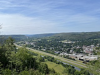
Corning is a town in Steuben County, New York, United States. The town is in the eastern part of the county and borders the city of Corning. The town population was 5,986 at the 2020 census. The town is named after Erastus Corning, a financier.

References

  1. "2016 U.S. Gazetteer Files". United States Census Bureau. Retrieved July 5, 2017.
  2. 1 2 3 4 Bureau, US Census. "City and Town Population Totals: 2020—2021". Census.gov. US Census Bureau. Retrieved October 4, 2022.
  3. 1 2 "Caton - Part of the Steuben Co., NY GenWeb page - Judy Cwiklinski - coordinator". sites.rootsweb.com. Retrieved January 15, 2024.
  4. Thrall, W. B. (1942). Pioneer history & atlas of Steuben County, N.Y. : compiled from historical, statistical & official records. Allen County Public Library Genealogy Center. Perry, NY : Thrall.
  5. "Census of Population and Housing". Census.gov. Retrieved June 4, 2015.
  6. "U.S. Census website". United States Census Bureau . Retrieved January 31, 2008.
  7. Reichler, Joseph L., ed. (1979) [1969]. The Baseball Encyclopedia (4th ed.). New York: Macmillan Publishing. ISBN   0-02-578970-8.

42°03′22″N77°01′40″W / 42.05611°N 77.02778°W / 42.05611; -77.02778