Campbell, New York

Last updated

Campbell, New York
USA New York location map.svg
Red pog.svg
Campbell
Usa edcp location map.svg
Red pog.svg
Campbell
Coordinates: 42°14′5″N77°10′7″W / 42.23472°N 77.16861°W / 42.23472; -77.16861
Country United States
State New York
County Steuben
Area
[1]
  Total40.78 sq mi (105.62 km2)
  Land40.69 sq mi (105.37 km2)
  Water0.09 sq mi (0.24 km2)
Elevation
1,657 ft (505 m)
Population
 (2020) [2]
  Total3,163 Decrease2.svg
  Estimate 
(2021) [2]
3,121
  Density81.04/sq mi (31.29/km2)
Time zone UTC-5 (Eastern (EST))
  Summer (DST) UTC-4 (EDT)
ZIP code
14821
Area code 607
FIPS code 36-11946
GNIS feature ID0978780
Website www.campbellny.com

Campbell is a town in Steuben County, New York, United States. The population was 3,163 at the 2020 census. [2] The name is from Robert Campbell, an early landowner. The town is centrally located in the county and is northwest of Corning.

Contents

History

Campbell was first settled around 1801. The town was formed in 1831 from the town of Hornby.

The District School Number Five and Wood Road Metal Truss Bridge are listed on the National Register of Historic Places. [3]

Notable people

Campbell was the birthplace, in 1869, of Illinois Attorney General Edward J. Brundage and, in 1874, of IBM founder Thomas J. Watson, Sr. Locally the town is known as Camp-Bell, probably after a campground of the same name.

Geography

According to the United States Census Bureau, the town has a total area of 40.8 square miles (106 km2), of which 40.8 square miles (106 km2) is land and 0.04 square miles (0.10 km2) (0.07%) is water.

Interstate 86 (including New York State Route 17), New York State Route 415 and the Conhocton River pass through the town.

Former New York State Route 333, now County Road 333, enters the town from the west.

Campbell is on the Gang Mills (Painted Post) Line of the B&H Rail Corporation. This portion of track was opened in 1882 as the New York (Hoboken) to Buffalo line of the Delaware, Lackawanna & Western Railroad. In 1963, the route to Buffalo was severed between Wayland and Groveland, N.Y., by order of the U. S. Interstate Commerce Commission in order to promote highway transportation.

Campbell was also served (c. 1853-1963) by the Corning-Rochester line of the Erie Railroad. This line was removed in 1963 by the ICC, also in order to promote highway transportation.

Demographics

Historical population
CensusPop.Note
1840 852
1850 1,17537.9%
1860 1,62238.0%
1870 1,98922.6%
1880 1,881−5.4%
1890 1,533−18.5%
1900 1,467−4.3%
1910 1,204−17.9%
1920 1,032−14.3%
1930 1,26322.4%
1940 1,47216.5%
1950 1,81423.2%
1960 2,47136.2%
1970 3,18028.7%
1980 3,80119.5%
1990 3,658−3.8%
2000 3,6910.9%
2010 3,406−7.7%
2020 3,163−7.1%
2021 (est.)3,121 [2] −1.3%
U.S. Decennial Census [4]

As of the census [5] of 2000, there were 3,691 people, 1,418 households, and 1,036 families residing in the town. The population density was 90.6 inhabitants per square mile (35.0/km2). There were 1,515 housing units at an average density of 37.2 per square mile (14.4/km2). The racial makeup of the town was 98.54% White, 0.43% African American, 0.08% Native American, 0.27% Asian, 0.03% Pacific Islander, 0.16% from other races, and 0.49% from two or more races. Hispanic or Latino of any race were 0.35% of the population.

There were 1,418 households, out of which 33.7% had children under the age of 18 living with them, 58.8% were married couples living together, 9.0% had a female householder with no husband present, and 26.9% were non-families. 21.4% of all households were made up of individuals, and 8.0% had someone living alone who was 65 years of age or older. The average household size was 2.59 and the average family size was 2.99.

In the town, the population was spread out, with 26.0% under the age of 18, 7.2% from 18 to 24, 27.7% from 25 to 44, 26.3% from 45 to 64, and 12.8% who were 65 years of age or older. The median age was 38 years. For every 100 females, there were 96.9 males. For every 100 females age 18 and over, there were 95.0 males.

The median income for a household in the town was $39,375, and the median income for a family was $46,220. Males had a median income of $30,820 versus $24,427 for females. The per capita income for the town was $18,819. About 6.1% of families and 8.2% of the population were below the poverty line, including 13.4% of those under age 18 and 4.0% of those age 65 or over.

Politics

Like most of Steuben County, Campbell is a Republican stronghold, with few Democrats on the Town Board.

Communities and locations in the Town of Campbell

Related Research Articles

<span class="mw-page-title-main">Steuben County, New York</span> County in New York, United States

Steuben County (stu-BEN) is a county located in the U.S. state of New York. As of the 2020 census, the population was 93,584. Its county seat is Bath. Its name is in honor of Baron von Steuben, a Prussian general who fought on the American side in the American Revolutionary War, though it is not pronounced the same. The county is part of the Southern Tier region of the state.

<span class="mw-page-title-main">Schuyler, New York</span> Town in Herkimer County, New York, US

Schuyler is a town in Herkimer County, New York, United States. The population was 3,420 at the 2010 census. The town is in the western part of Herkimer County and is east of Utica.

Springwater is a town in Livingston County, New York, United States. The population was 2,439 at the 2010 census. Springwater is in the southeast part of the county.

Orange is a town in Schuyler County, New York, United States. The population was 1,408 at the 2020 census.

Dansville is a town in Steuben County, New York, United States, not to be confused with the nearby village of Dansville in Livingston County. The population was 1,842 at the 2010 census. The town was named after Daniel Faulkner.

<span class="mw-page-title-main">Erwin, New York</span> Town in New York, United States

Erwin is a town in Steuben County, New York, United States. The population was 8,090 at the 2020 census. The name is that of an early settler, who became the first Town Supervisor. Erwin is in the southeast part of the county and is west of the city of Corning.

Fremont is a town in Steuben County, New York, United States. The population was 898 at the 2020 census. The town is named after General John Fremont.

Jasper is a town located in Steuben County, New York, United States. As of the 2020 census, the town had a total population of 1,418. The name is that of a military hero at Fort Moultrie, William Jasper.

<span class="mw-page-title-main">Lindley, New York</span> Town in New York, United States

Lindley is a town in southern Steuben County, New York, United States. The population was 1,816 at the 2020 census. The town was named after the early settler Eleazer Lindsley.

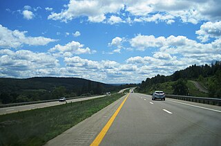
Savona is a village in Steuben County, New York, United States. The population was 827 at the 2010 census. The village is named after Savona in Italy, and is located in the eastern part of the town of Bath. The village is located at the intersection of routes 226 and 415, and Interstate 86.

Thurston is a town in Steuben County, New York, United States. The population was 1,248 at the 2020 United States census. The town is named after early landowner William Thurston.

Tuscarora township is a township in Steuben County, New York, United States. The population was 1,388 at the 2020 census. The township is named after the Tuscarora tribe.

West Union is a town in Steuben County, New York, United States. The population was 343 as of the 2020 decennial census.

Avoca is a village located in the town of the same name in Steuben County, New York, United States. The population was 946 at the 2010 census. It is in the eastern part of the town, northwest of Bath.

<span class="mw-page-title-main">Avoca, New York</span> Town in New York, United States

Avoca is a town in Steuben County, New York, United States. The population was 1,996 at the 2020 census.

<span class="mw-page-title-main">Bath, New York</span> Town in New York, United States

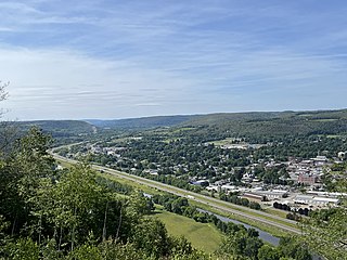
Bath is a town in Steuben County, New York, United States, with an area of 96.3 square miles and a population of 11,426 in 2020. Its largest settlement is the Village of Bath, which has an area of 2.9 sq mi and a population of 5,641. The Village is the county seat of Steuben County. The Town is located in the central part of the county, northwest of Elmira. The town and village are either named after the city of Bath in England or after Lady Bath, daughter of a landowner.

<span class="mw-page-title-main">Cohocton (village), New York</span> Village in New York, United States

Cohocton is a village in Steuben County, New York, United States. The population was 838 at the 2010 census. The name is derived from an Iroquois phrase for "log in the water."

Cohocton is a town in Steuben County, New York, United States. The population was 2,268 at the 2020 census. The town contains a village, also called Cohocton and is located in the northwestern part of the county.

Corning is a town in Steuben County, New York, United States. The town is in the eastern part of the county and borders the city of Corning. The town population was 5,986 at the 2020 census. The town is named after Erastus Corning, a financier.

Wayland is a town in Steuben County, New York, United States. The population was 3,733 at the 2020 census.

References

  1. "2016 U.S. Gazetteer Files". United States Census Bureau. Retrieved July 5, 2017.
  2. 1 2 3 4 Bureau, US Census. "City and Town Population Totals: 2020—2021". Census.gov. US Census Bureau. Retrieved October 4, 2022.
  3. "National Register Information System". National Register of Historic Places . National Park Service. March 13, 2009.
  4. "Census of Population and Housing". Census.gov. Retrieved June 4, 2015.
  5. "U.S. Census website". United States Census Bureau . Retrieved January 31, 2008.