Urbana, New York

Last updated

Urbana, New York
USA New York location map.svg
Red pog.svg
Urbana, New York
Location within the state of New York
Coordinates: 42°24′32″N77°14′1″W / 42.40889°N 77.23361°W / 42.40889; -77.23361
Country United States
State New York
County Steuben
Area
[1]
  Total44.18 sq mi (114.42 km2)
  Land40.95 sq mi (106.05 km2)
  Water3.23 sq mi (8.37 km2)
Elevation
833 ft (254 m)
Population
 (2020) [2]
  Total2,125 Decrease2.svg
  Estimate 
(2021) [2]
2,101
  Density55.59/sq mi (21.46/km2)
Time zone UTC-5 (Eastern (EST))
  Summer (DST) UTC-4 (EDT)
FIPS code 36-76496
GNIS feature ID0979574

Urbana is a town in Steuben County, New York, United States. The population was 2,125 at the 2020 census. [2]

Contents

The Town of Urbana is in the northeastern part of the county and is northeast of Bath.

History

The town was first settled around 1793. The town was formed from part of the Town of Bath in 1822. The first grape vines were planted around 1829, beginning the modern prominence of the wine industry.

The town and its village, Hammondsport, is one of the cradles of aviation, due to the inventions of Glenn Curtiss.

The Timothy M. Younglove Octagon House is listed on the National Register of Historic Places. [3]

Geography

According to the United States Census Bureau, the town has a total area of 44.2 square miles (114 km2), of which 41.1 square miles (106 km2) is land and 3.0 square miles (7.8 km2) (6.86%) is water.

The town is at the southern end of Keuka Lake, one of the Finger Lakes.

New York State Route 54A rejoins New York State Route 54 near Hammondsport.

Demographics

Historical population
CensusPop.Note
1830 1,288
1840 1,88446.3%
1850 2,07910.4%
1860 1,983−4.6%
1870 2,0825.0%
1880 2,31811.3%
1890 2,59011.7%
1900 2,6923.9%
1910 2,659−1.2%
1920 2,300−13.5%
1930 2,108−8.3%
1940 2,32210.2%
1950 2,4505.5%
1960 2,5925.8%
1970 2,6943.9%
1980 2,98210.7%
1990 2,807−5.9%
2000 2,548−9.2%
2010 2,343−8.0%
2020 2,125−9.3%
2021 (est.)2,101 [2] −1.1%
U.S. Decennial Census [4]

As of the census [5] of 2000, there were 2,546 people, 1,028 households, and 688 families residing in the town. The population density was 61.9 people per square mile (23.9 people/km2). There were 1,434 housing units at an average density of 34.9 per square mile (13.5/km2). The racial makeup of the town was 97.53% White, 0.75% African American, 0.16% Native American, 0.55% Asian, 0.16% from other races, and 0.86% from two or more races. Hispanic or Latino of any race were 0.35% of the population.

There were 1,028 households, out of which 26.8% had children under the age of 18 living with them, 53.9% were married couples living together, 9.0% had a female householder with no husband present, and 33.0% were non-families. 27.2% of all households were made up of individuals, and 10.3% had someone living alone who was 65 years of age or older. The average household size was 2.36 and the average family size was 2.83.

In the town, the population was spread out, with 21.8% under the age of 18, 4.9% from 18 to 24, 24.0% from 25 to 44, 28.9% from 45 to 64, and 20.3% who were 65 years of age or older. The median age was 44 years. For every 100 females, there were 94.1 males. For every 100 females age 18 and over, there were 92.1 males.

The median income for a household in the town was $39,184, and the median income for a family was $43,309. Males had a median income of $32,500 versus $26,528 for females. The per capita income for the town was $19,584. About 8.0% of families and 9.8% of the population were below the poverty line, including 16.1% of those under age 18 and 4.3% of those age 65 or over.

Communities and locations in the Town of Urbana

Related Research Articles

<span class="mw-page-title-main">Fleming, New York</span> Town in New York, United States

Fleming is a town in Cayuga County, New York, United States. The population was 2,475 at the 2020 census. The name is that of General George Fleming, an early settler. Fleming is at the northern end of Owasco Lake, south of Auburn.

<span class="mw-page-title-main">North Harmony, New York</span> Town in New York, United States

North Harmony is a town in Chautauqua County, New York, United States. The population was 2,182 at the 2020 census. The town is on the west side of Chautauqua Lake. The shore of the lake is the location of many summer resort communities.

<span class="mw-page-title-main">Pomfret, New York</span> Town in New York, United States

Pomfret is a town in Chautauqua County, New York, United States. The population was 13,236 at the 2020 census. The town lies in the north-central part of the county, south of Dunkirk, and includes the village of Fredonia.

<span class="mw-page-title-main">Caroga, New York</span> Town in New York, United States

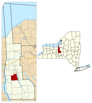
Caroga is a town in Fulton County, New York, United States. The population was 1,205 at the 2010 census. The town was named after a local creek.

<span class="mw-page-title-main">Darien, New York</span> Town in Genesee County, New York

Darien is a town in Genesee County, New York, United States. The population was 3,010 at the 2020 census. Darien lies in the southwestern part of Genesee County, southwest of Batavia.

<span class="mw-page-title-main">Somerset, New York</span> Town in New York, United States

Somerset is a town in Niagara County, New York, United States. The population was 2,662 at the 2010 census. The town is believed to be named after Somerset, New Jersey, the source of some early settlers.

<span class="mw-page-title-main">Vienna, New York</span> Town in New York, United States

Vienna is a town in Oneida County, New York, United States. The population was 5,440 at the 2010 census. The town is named after the capital of Austria.

Gorham is a town in Ontario County, New York, United States. The population was 4,130 at the 2020 census. The town is named after Nathaniel Gorham.

<span class="mw-page-title-main">Exeter, New York</span> Town in New York, United States

Exeter is a town in Otsego County, New York, United States. The town is located in the northern part of the county. The population was 987 at the 2010 census. It is named after the county town and cathedral city of Exeter in England.

<span class="mw-page-title-main">Pitcairn, New York</span> Town in New York, United States

Pitcairn is a town in St. Lawrence County, New York, United States. The population was 846 at the 2010 census. The name is from that of Joseph Pitcairn, an early landowner and diplomat.

<span class="mw-page-title-main">Hammondsport, New York</span> Village in New York, United States

Hammondsport is a village in Steuben County, New York, United States. First settled in 1792 the village is located at the south end of Keuka Lake, one of the Finger Lakes. Beginning in the 1790s the village began to take form, which included a courthouse and a jail. In the 1850s vineyards and the wine industry began to emerge in and around Hammondsport. Pioneer aviation engineer and pilot Glenn Curtiss was born in Hammondsport, where he built several types of aircraft, and the first seaplanes, which were tested in Keuka Lake. Hammondsport features a village square, historic buildings, wineries, breweries and museums. Nearby municipalities contain vineyards, and wineries and grape-packing have played a major role in the economy. In 1935, heavy rains lasting three days resulted in mudslides and major flooding, ruining or damaging many homes and structures in Hammondsport, situated at the hillside. A number of buildings surrounding Pulteney Square make up the Pulteney Square Historic District and are listed in the National Register of Historic Places

Pulteney is a town in Steuben County, New York, United States. The population was 1,260 at the 2020 census. The name is derived from the name of the original pioneer tract of land.

Wayne is a town located in the northeast corner of Steuben County, New York, United States. As of the 2020 census, the town population was 1,006. The town was named after the Revolutionary War general, Anthony Wayne.

<span class="mw-page-title-main">Wheeler, New York</span> Town in New York, United States

Wheeler is a town in Steuben County, New York, United States. The population was 1,136 at the 2020 census. The town is named after Captain Silas Wheeler, an early settler.

<span class="mw-page-title-main">Barrington, New York</span> Town in New York, United States

Barrington is a town in Yates County, New York, United States. The population was 1,681 at the 2010 census.

<span class="mw-page-title-main">Jerusalem, New York</span> Town in New York, United States

Jerusalem is a town in Yates County, New York. The population was 4,405 at the 2020 census. The town is named after the city of Jerusalem.

<span class="mw-page-title-main">Milo, New York</span> Town in New York, United States

Milo is a town in Yates County, New York, United States. The population was 7,006 at the 2010 census. The town was named after Milo of Croton, a famous athlete from Ancient Greece.

<span class="mw-page-title-main">Torrey, New York</span> Town in New York, United States

Torrey is a town in Yates County, New York, United States. The population was 1,282 at the 2010 census. The name is taken from that of early county political leader Henry Torrey.

<span class="mw-page-title-main">Wilson, New York</span> Town in New York, United States

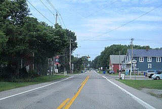
Wilson is a town in Niagara County, New York, United States. The population was 5,993 at the 2010 census. The town was named after an early settler, Reuben Wilson, who built and dwelt in a log cabin on the shore of Lake Ontario at the site of what would become the Village of Wilson.

<span class="mw-page-title-main">New York State Route 54A</span> State highway in western New York, US

New York State Route 54A (NY 54A) is a state highway in the western part of New York in the United States. It runs in a northeast to southwest direction through part of the Finger Lakes district of New York. The southern terminus of NY 54A is at NY 54 south of Hammondsport. The northern terminus is in Penn Yan, where it rejoins NY 54. Unlike NY 54, which runs along the east side of Keuka Lake, NY 54A has a more circuitous route around the western side of the lake.

References

  1. "2016 U.S. Gazetteer Files". United States Census Bureau. Retrieved July 5, 2017.
  2. 1 2 3 4 Bureau, US Census. "City and Town Population Totals: 2020—2021". Census.gov. US Census Bureau. Retrieved October 6, 2022.
  3. 1 2 3 "National Register Information System". National Register of Historic Places . National Park Service. March 13, 2009.
  4. "Census of Population and Housing". Census.gov. Retrieved June 4, 2015.
  5. "U.S. Census website". United States Census Bureau . Retrieved January 31, 2008.

42°27′16″N77°10′52″W / 42.45444°N 77.18111°W / 42.45444; -77.18111