Carbondale, Indiana

Last updated

Carbondale, Indiana
Locator map of Warren County, Indiana.svg
Red pog.svg
Carbondale
USA Indiana location map.svg
Red pog.svg
Carbondale
Usa edcp location map.svg
Red pog.svg
Carbondale
Coordinates: 40°21′36″N87°20′52″W / 40.36000°N 87.34778°W / 40.36000; -87.34778
Country United States
State Indiana
County Warren
Township Liberty
Elevation
[1]
689 ft (210 m)
Time zone UTC-5 (Eastern (EST))
  Summer (DST) UTC-4 (EDT)
ZIP code
47993
Area code 765
GNIS feature ID432124 [1]

Carbondale is an unincorporated community in Liberty Township, Warren County, in the U.S. state of Indiana. [1]

Contents

History

The Nelson Burr home near Carbondale, built in 1857 Nelson Burr home near Carbondale, Indiana.png
The Nelson Burr home near Carbondale, built in 1857

Carbondale was known as Clark's Cross Roads at least as early as 1846; later it was called Free Hall. The discovery of coal in the town's vicinity led to the current name being applied in 1873. [2] [3] The first house was built here in 1854 by John Thompson; another was built the next year by Andrew Brier, and a church was constructed in 1867. [4]

A post office was established in 1855 under the name Clark's Cross Roads, and was discontinued in 1858. In 1873, another post office was established with the name Carbondale but was also discontinued, in 1904. [5]

Geography

Carbondale is located just east of the intersection of U.S. Route 41 and State Road 63, about 6 miles north-northwest of the county seat of Williamsport. The scenic Big Pine Creek flows about a mile and a half east of town.

Related Research Articles

<span class="mw-page-title-main">Warren County, Indiana</span> County in Indiana, United States

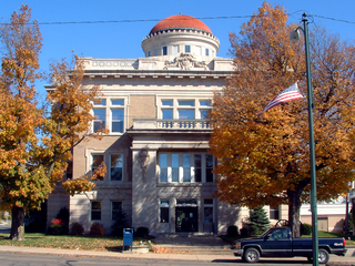
Warren County is a county in the U.S. state of Indiana. It lies in the western part of the state between the Illinois state line and the Wabash River. According to the 2020 census, it had a population of 8,440. Its county seat is Williamsport.

<span class="mw-page-title-main">West Lebanon, Indiana</span> Town in Indiana, United States

West Lebanon is a town in Pike Township, Warren County, in the U.S. state of Indiana. The population was 723 at the 2010 census.

<span class="mw-page-title-main">Liberty Township, Warren County, Indiana</span> Township in Indiana, United States

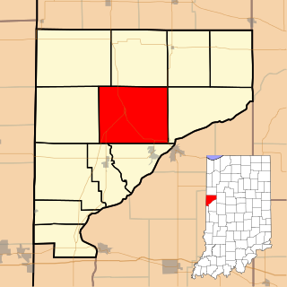
Liberty Township is one of twelve townships in Warren County, Indiana, United States. According to the 2010 census, its population was 896 and it contained 362 housing units.

Baltimore was a small town built on the western banks of the Wabash River in Mound Township, Warren County, in the U.S. state of Indiana.

Foster is a small unincorporated community in Mound Township, Warren County, in the U.S. state of Indiana.

<span class="mw-page-title-main">Hedrick, Indiana</span> Unincorporated community and Census-designated place in Indiana, United States

Hedrick is a small unincorporated community in Jordan Township, Warren County, in the U.S. state of Indiana.

<span class="mw-page-title-main">Johnsonville, Indiana</span> Unincorporated community in Indiana, United States

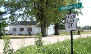
Johnsonville is a small unincorporated community in Steuben Township, Warren County, in the U.S. state of Indiana.

<span class="mw-page-title-main">Judyville, Indiana</span> Unincorporated community and Census-designated place in Indiana, United States

Judyville is a small unincorporated community in Liberty Township, Warren County, in the U.S. state of Indiana.

<span class="mw-page-title-main">Marshfield, Indiana</span> Unincorporated community and Census-designated place in Indiana, United States

Marshfield is a small unincorporated community in Steuben Township, Warren County, in the U.S. state of Indiana.

Pence is a small unincorporated community in Jordan Township, Warren County, in the U.S. state of Indiana.

<span class="mw-page-title-main">Templeton, Indiana</span> Unincorporated community in Indiana, United States

Templeton is an unincorporated community in Bolivar Township, Benton County, in the U.S. state of Indiana. It is part of the Lafayette, Indiana Metropolitan Statistical Area.

<span class="mw-page-title-main">Talbot, Indiana</span> Unincorporated community in Indiana, United States

Talbot is an unincorporated community in Hickory Grove Township, Benton County, in the U.S. state of Indiana. It is part of the Lafayette, Indiana Metropolitan Statistical Area.

<span class="mw-page-title-main">Atkinson, Indiana</span> Unincorporated community in Indiana, United States

Atkinson is an unincorporated community in Center Township, Benton County, in the U.S. state of Indiana. The site of Atkinson is home to the county's only junior/senior high school, Benton Central.

<span class="mw-page-title-main">Chase, Indiana</span> Unincorporated community in Indiana, United States

Chase is an unincorporated community in Grant Township, Benton County, in the U.S. state of Indiana. Though virtually extinct, Chase still persists on state and county maps and retains a single business in the form of grain elevators operated by Boswell Chase Grain, Inc. A few miles away is the Daughtery Motor Speedway.

Walnut Grove was a small town in Prairie Township, Warren County, Indiana, located three miles east of Tab. A 1913 history describes the town's population as about 50.

New Columbus is an unincorporated community in Adams Township, Madison County, Indiana, United States. It is also known as Ovid, and is marked by both names on highway signs at the town's borders.

<span class="mw-page-title-main">Concord, Tippecanoe County, Indiana</span> Unincorporated community in Indiana, United States

Concord is a small unincorporated community in Lauramie Township, Tippecanoe County, Indiana, located just west of Stockwell.

<span class="mw-page-title-main">Mier, Indiana</span> Census-designated place in Indiana, United States

Mier is an unincorporated community and census-designated place (CDP) in Richland Township, Grant County, Indiana, in the United States. As of the 2010 census it had a population of 78.

Cuba is an unincorporated community in the northwestern part of Montgomery Township, Owen County, in the U.S. state of Indiana. It lies near the intersection of County Road 150 West and County Road 600 North, which is a community about ten miles north of the town of Spencer, the county seat of Owen County. Its elevation is 722 feet, and it is located at 39°22′41″N86°47′53″W.

References

  1. 1 2 3 U.S. Geological Survey Geographic Names Information System: Carbondale, Indiana
  2. A History of Warren County, Indiana (175th Anniversary Edition). Warren County Historical Society. 2002. p. 42.
  3. Baker, Ronald L.; Carmony, Marvin (1975). Indiana Place Names. Bloomington, Indiana: Indiana University Press. p. 24.
  4. Clifton, Thomas, ed. (1913). Past and Present of Fountain and Warren Counties Indiana. Indianapolis: B. F. Bowen and Company. p. 325.
  5. "Warren County". Jim Forte Postal History. Retrieved July 10, 2016.