Washington Township, Warren County, Indiana

Last updated

Washington Township
Map highlighting Washington Township, Warren County, Indiana.svg
Location of Washington Township in Warren County
Map of USA IN.svg
Location of Indiana in the United States
Coordinates: 40°16′36″N87°19′41″W / 40.27667°N 87.32806°W / 40.27667; -87.32806
Country United States
State Indiana
County Warren
Government
  Type Indiana township
Area
  Total19.51 sq mi (50.5 km2)
  Land19.12 sq mi (49.5 km2)
  Water0.38 sq mi (1.0 km2)  1.95%
Elevation
[1]
669 ft (204 m)
Population
 (2010)
  Total2,298
  Density120.2/sq mi (46.4/km2)
Time zone UTC-5 (Eastern (EST))
  Summer (DST) UTC-4 (EDT)
Area code 765
GNIS feature ID 454022

Washington Township is one of twelve townships in Warren County, Indiana, United States. It is the most populous township in the county; according to the 2010 census, its population was 2,298, with 1,898 of those living in Williamsport, and it contained 1,011 housing units. It has the highest population density of the Warren County townships at about 120 inhabitants per square mile (46/km2). [2]

Contents

History

The area that became Washington Township was first settled in 1827. [3] Originally, the county was divided into four townships when it was formed in 1827; Washington Township was created a few years later in March 1830. [4]

Geography

According to the 2010 census, the township has a total area of 19.51 square miles (50.5 km2), of which 19.12 square miles (49.5 km2) (or 98.00%) is land and 0.38 square miles (0.98 km2) (or 1.95%) is water. [2] The Wabash River defines the township's southeastern border. Big Pine Creek flows through the far northeastern corner of the township on its way to the Wabash River. [5] The streams of Clear Branch, Dry Branch, Fall Branch and Rock Creek also run through this township.

The county seat of Williamsport is in the east part of the township, near the river. Williamsport Falls, the highest waterfall in the State of Indiana, is in downtown Williamsport; the stream of Fall Creek flows through the town and falls 90 feet (27 m) over a sandstone ledge. [6]

Map of Washington Township Map of Washington Township, Warren County, Indiana.svg
Map of Washington Township
1877 map of Washington Township Washington Township, Warren County, Indiana map from 1877 atlas.png
1877 map of Washington Township

Cemeteries

The township contains these four cemeteries: Highland, [7] Hillside, [8] Owens [9] and Robb. [10]

Transportation

Indiana State Road 28 passes through the township from east to west. Coming from the Illinois state line and West Lebanon, it goes directly east, then veers to the northeast and goes through Williamsport, then crosses the river and passes east through Attica in Fountain County. [11] U.S. Route 41 and State Road 55 pass through the northeastern corner of the township and briefly share the route of State Road 28. [12] [13]

A Norfolk Southern Railway line passes through the township from east to west, leaving the township when it also crosses the river. For much of its route through the township, it parallels State Road 28, running just south of the highway. [14]

Education

Washington Township is part of the Metropolitan School District of Warren County. It contains one of the three elementary schools in the county, located in Williamsport. [15]

Washington Township is served by the Williamsport-Washington Township Public Library. [16]

Government

Washington Township has a trustee who administers rural fire protection and ambulance service, provides relief to the poor, manages cemetery care, and performs farm assessment, among other duties. The trustee is assisted in these duties by a three-member township board. The trustees and board members are elected to four-year terms. [17]

Washington Township is part of Indiana's 8th congressional district, Indiana House of Representatives District 42, [18] and Indiana State Senate District 23. [19]

Climate and weather

Williamsport, Indiana
Climate chart (explanation)
J
F
M
A
M
J
J
A
S
O
N
D
 
 
1.7
 
 
30
13
 
 
1.6
 
 
35
17
 
 
3.2
 
 
47
27
 
 
3.6
 
 
60
38
 
 
4.2
 
 
72
49
 
 
4.5
 
 
81
59
 
 
3.7
 
 
84
62
 
 
3
 
 
82
59
 
 
2.6
 
 
77
51
 
 
3
 
 
64
39
 
 
3
 
 
48
30
 
 
2.5
 
 
35
19
Average max. and min. temperatures in °F
Precipitation totals in inches
Source:The Weather Channel [20]
Metric conversion
J
F
M
A
M
J
J
A
S
O
N
D
 
 
42
 
 
−1
−11
 
 
40
 
 
2
−8
 
 
80
 
 
8
−3
 
 
90
 
 
16
3
 
 
106
 
 
22
9
 
 
114
 
 
27
15
 
 
93
 
 
29
17
 
 
77
 
 
28
15
 
 
67
 
 
25
11
 
 
75
 
 
18
4
 
 
75
 
 
9
−1
 
 
64
 
 
2
−7
Average max. and min. temperatures in °C
Precipitation totals in mm

In recent years, average temperatures in Williamsport have ranged from a low of 13 °F (−11 °C) in January to a high of 84 °F (29 °C) in July, with a record low of −24 °F (−31 °C) recorded in January 1999 and a record high of 99 °F (37 °C) in July 1995. Average monthly precipitation ranges from 1.59 inches (40 mm) in February to 4.50 inches (114 mm) in June. [20]

Related Research Articles

<span class="mw-page-title-main">Adams Township, Warren County, Indiana</span> Township in Indiana, United States

Adams Township is one of twelve townships in Warren County, Indiana. According to the 2010 census, its population was 512 and it contained 250 housing units.

<span class="mw-page-title-main">Jordan Township, Warren County, Indiana</span> Township in Indiana, United States

Jordan Township is one of twelve townships in Warren County, Indiana, United States. According to the 2010 census, its population was 247 and it contained 105 housing units. It is almost entirely agricultural and contains no incorporated towns.

<span class="mw-page-title-main">Kent Township, Warren County, Indiana</span> Township in Indiana, United States

Kent Township is one of twelve townships in Warren County, Indiana, United States. According to the 2010 census, its population was 428 and it contained 196 housing units.

<span class="mw-page-title-main">Liberty Township, Warren County, Indiana</span> Township in Indiana, United States

Liberty Township is one of twelve townships in Warren County, Indiana, United States. According to the 2010 census, its population was 896 and it contained 362 housing units.

<span class="mw-page-title-main">Medina Township, Warren County, Indiana</span> Township in Indiana, United States

Medina Township is one of twelve townships in Warren County, Indiana, United States. According to the 2010 census, its population was 457 and it contained 191 housing units.

<span class="mw-page-title-main">Mound Township, Warren County, Indiana</span> Township in Indiana, United States

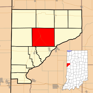
Mound Township is one of twelve townships in Warren County, Indiana, United States. According to the 2010 census, its population was 418 and it contained 183 housing units.

<span class="mw-page-title-main">Pike Township, Warren County, Indiana</span> Township in Indiana, United States

Pike Township is one of twelve townships in Warren County, Indiana, United States. According to the 2010 census, its population was 1,221 and it contained 529 housing units.

<span class="mw-page-title-main">Pine Township, Warren County, Indiana</span> Township in Indiana, United States

Pine Township is one of twelve townships in Warren County, Indiana, United States. According to the 2010 census, its population was 481 and it contained 213 housing units.

<span class="mw-page-title-main">Prairie Township, Warren County, Indiana</span> Township in Indiana, United States

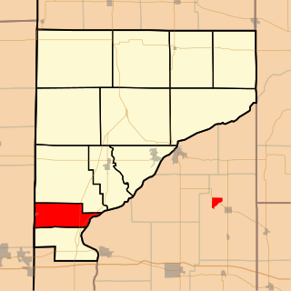
Prairie Township is one of twelve townships in Warren County, Indiana, United States. According to the 2010 census, its population was 257 and it contained 117 housing units; the population density is the lowest of any township in the county, at 6.1 inhabitants per square mile (2.4/km2).

<span class="mw-page-title-main">Steuben Township, Warren County, Indiana</span> Township in Indiana, United States

Steuben Township is one of twelve townships in Warren County, Indiana, United States. It was established in 1834. According to the 2010 census, its population was 487 and it contained 199 housing units. It contains no incorporated towns and is largely agricultural.

<span class="mw-page-title-main">Warren Township, Warren County, Indiana</span> Township in Indiana, United States

Warren Township is one of twelve townships in Warren County, Indiana, United States. According to the 2010 census, its population was 806 and it contained 324 housing units.

<span class="mw-page-title-main">Cain Township, Fountain County, Indiana</span> Township in Indiana, United States

Cain Township is one of eleven townships in Fountain County, Indiana. As of the 2010 census, its population was 1,142 and it contained 488 housing units.

<span class="mw-page-title-main">Davis Township, Fountain County, Indiana</span> Township in Indiana, United States

Davis Township is one of eleven townships in Fountain County, Indiana, United States. As of the 2010 census, its population was 682 and it contained 286 housing units.

<span class="mw-page-title-main">Fulton Township, Fountain County, Indiana</span> Township in Indiana, United States

Fulton Township is one of eleven townships in Fountain County, Indiana, United States. As of the 2000 census, its population was 674.

<span class="mw-page-title-main">Logan Township, Fountain County, Indiana</span> Township in Indiana, United States

Logan Township is one of eleven townships in Fountain County, Indiana, United States. As of the 2010 census, its population was 3,672 and it contained 1,685 housing units.

<span class="mw-page-title-main">Richland Township, Fountain County, Indiana</span> Township in Indiana, United States

Richland Township is one of eleven townships in Fountain County, Indiana, United States. As of the 2010 census, its population was 950 and it contained 423 housing units.

<span class="mw-page-title-main">Jefferson Township, Boone County, Indiana</span> Township in Indiana, United States

Jefferson Township is one of twelve townships in Boone County, Indiana. As of the 2010 census, its population was 1,464 and it contained 544 housing units.

<span class="mw-page-title-main">Forest Township, Clinton County, Indiana</span> Township in Indiana, United States

Forest Township is one of fourteen townships in Clinton County, Indiana. As of the 2010 census, its population was 760 and it contained 328 housing units. The township was named for the large amount of timber it contained at the time it was organized.

<span class="mw-page-title-main">Clay Township, Hamilton County, Indiana</span> Township in Indiana, United States

Clay Township is one of nine townships in Hamilton County, Indiana, United States. As of the 2010 census, its population was 83,293 and it contained 32,375 housing units. With the annexation of Home Place, Indiana, Carmel, became completely coterminous with the township.

<span class="mw-page-title-main">Cleveland Township, Whitley County, Indiana</span> Township in Indiana, United States

Cleveland Township is one of nine townships in Whitley County, Indiana, United States. As of the 2010 census, its population was 3,398 and it contained 1,441 housing units.

References

  1. "US Board on Geographic Names". United States Geological Survey. October 25, 2007. Retrieved May 9, 2017.
  2. 1 2 "Population, Housing Units, Area, and Density: 2010 - County -- County Subdivision and Place -- 2010 Census Summary File 1". United States Census. Archived from the original on February 12, 2020. Retrieved May 10, 2013.
  3. Clifton 1913, p. 325.
  4. Warren County Historical Society 1966, p. 130.
  5. "Big Pine Creek". Indiana Department of Natural Resources . Retrieved October 30, 2010.
  6. "Williamsport Falls". Purdue University Cooperative Extension Service. Retrieved August 28, 2010.
  7. "Highland Cemetery". Geographic Names Information System . United States Geological Survey, United States Department of the Interior . Retrieved January 27, 2011.
  8. "Hillside Cemetery". Geographic Names Information System . United States Geological Survey, United States Department of the Interior . Retrieved January 27, 2011.
  9. "Owens Cemetery". Geographic Names Information System . United States Geological Survey, United States Department of the Interior . Retrieved January 27, 2011.
  10. "Robb Cemetery". Geographic Names Information System . United States Geological Survey, United States Department of the Interior . Retrieved January 27, 2011.
  11. "State Road 28". Highway Explorer. Retrieved September 21, 2010.
  12. "State Road 55". Highway Explorer. Retrieved September 21, 2010.
  13. "U.S. Route 41". Highway Explorer. Retrieved September 21, 2010.
  14. "State of Indiana 2012 Rail System Map" (PDF). Indiana Department of Transportation. 2012. Retrieved December 2, 2013.
  15. "Corporation Snapshot, M S D Warren County #8115". Indiana Department of Education. Retrieved January 27, 2011.
  16. "Indiana public library directory" (PDF). Indiana State Library. Retrieved March 15, 2018.
  17. "Government". United Township Association of Indiana. Retrieved January 6, 2011.
  18. "Indiana Senate" (PDF). State of Indiana. Retrieved December 2, 2013.
  19. "Indiana House Districts" (PDF). State of Indiana. Retrieved December 2, 2013.
  20. 1 2 "Monthly Averages for Williamsport, Indiana". The Weather Channel. Retrieved January 27, 2011.

Bibliography