Carleton Parish, New Brunswick

Last updated

Carleton
Kent County NB - Carleton Parish.PNG
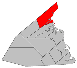
Location within Kent County, New Brunswick.
Coordinates: 46°48′18″N65°03′54″W / 46.805°N 65.065°W / 46.805; -65.065
Country Flag of Canada (Pantone).svg  Canada
Province Flag of New Brunswick.svg  New Brunswick
County Kent County
Erected1814
Area
[1]
  Land435.23 km2 (168.04 sq mi)
Population
 (2021) [1]
  Total764
  Density1.8/km2 (5/sq mi)
  Change 2016-2021
Increase2.svg 7.9%
  Dwellings
413
Time zone UTC-4 (AST)
  Summer (DST) UTC-3 (ADT)

Carleton is a geographic parish in Kent County, New Brunswick, Canada. [4]

Contents

For governance purposes it is mainly part of the Kent rural district, [5] which is a member of the Kent Regional Service Commission. [6] Small areas on the southern and western boundaries belong to the town of Beaurivage and the village of Nouvelle-Arcadie, respectively. [lower-alpha 1]

Prior to the 2023 governance reform, the parish was divided between the local service districts of Pointe-Sapin, east of the national park, and the parish of Carleton, to its west. [8]

Origin of name

The parish was named for Thomas Carleton, first Governor of New Brunswick. [9]

History

Carleton was erected in 1814 as part of Northumberland County from Newcastle Parish. [10] It included Acadieville, Richibucto, Saint-Louis, and Weldford Parishes.

In 1827 Richibucto was erected as Liverpool Parish, including modern Weldford Parish. [11]

In 1845 the boundary with Northumberland County was adjusted, adding area to Carleton. [12]

In 1855 Saint-Louis was erected as Palmerston Parish. [13]

In 1857 the boundary with Palmerston was adjusted to run along grant lines. [14]

In 1876 Acadieville was erected as its own parish. [15]

In 1888 a small area at Point Escuminac was returned to Northumberland County. [16]

Boundaries

Carleton Parish is bounded: [2] [17] [18] [19]

Communities

Communities at least partly within the parish; [17] [18] [19]

Bodies of water

Bodies of water [lower-alpha 3] at least partly in the parish: [17] [18] [19]

Other notable places

Parks, historic sites, and other noteworthy places at least partly in the parish. [17] [18] [19] [21]

Demographics

Revised census figures based on the 2023 local governance reforms have not been released.

See also

Notes

  1. Maps still visible as thumbnails show the current and previous governance boundaries. [7]
  2. By the magnet of 1857, [14] when declination in the area was between 21º and 22º west of north. [20]
  3. Not including brooks, ponds or coves.

Related Research Articles

<span class="mw-page-title-main">Saumarez Parish, New Brunswick</span> Parish in New Brunswick, Canada

Saumarez is a geographic parish in Gloucester County, New Brunswick, Canada.

<span class="mw-page-title-main">Dundas Parish, New Brunswick</span> Parish in Canada

Dundas is a geographic parish in Kent County, New Brunswick, Canada.

<span class="mw-page-title-main">Addington Parish, New Brunswick</span> Parish in New Brunswick, Canada

Addington is a geographic parish in Restigouche County, New Brunswick, Canada.

<span class="mw-page-title-main">Queensbury Parish, New Brunswick</span> Parish in New Brunswick, Canada

Queensbury is a geographic parish in York County, New Brunswick, Canada.

<span class="mw-page-title-main">Acadieville Parish, New Brunswick</span> Parish in New Brunswick, Canada

Acadieville is a geographic parish in Kent County, New Brunswick, Canada.

<span class="mw-page-title-main">Hardwicke Parish, New Brunswick</span> Parish in New Brunswick, Canada

Hardwicke is a geographic parish in Northumberland County, New Brunswick, Canada.

<span class="mw-page-title-main">Wicklow Parish, New Brunswick</span> Parish in New Brunswick, Canada

Wicklow is a geographic parish in Carleton County, New Brunswick, Canada, forming the northwestern corner of Carleton County.

<span class="mw-page-title-main">Eldon Parish, New Brunswick</span> Parish in New Brunswick, Canada

Eldon is a geographic parish in Restigouche County, New Brunswick, Canada.

<span class="mw-page-title-main">Saint-Basile Parish, New Brunswick</span> Parish in New Brunswick, Canada

Saint-Basile is a geographic parish in Madawaska County, New Brunswick, Canada.

<span class="mw-page-title-main">Glenelg Parish, New Brunswick</span> Parish in New Brunswick, Canada

Glenelg is a geographic parish in Northumberland County, New Brunswick, Canada.

<span class="mw-page-title-main">Rogersville Parish, New Brunswick</span> Parish in New Brunswick, Canada

Rogersville is a geographic parish in Northumberland County, New Brunswick, Canada.

<span class="mw-page-title-main">Saint-Louis Parish, New Brunswick</span> Parish in New Brunswick, Canada

Saint-Louis is a geographic parish in Kent County, New Brunswick, Canada.

<span class="mw-page-title-main">Saint-Charles Parish, New Brunswick</span> Parish in New Brunswick, Canada

Saint-Charles is a geographic parish in Kent County, New Brunswick, Canada.

<span class="mw-page-title-main">Wellington Parish, New Brunswick</span> Parish in New Brunswick, Canada

Wellington is a geographic parish in Kent County, New Brunswick, Canada.

<span class="mw-page-title-main">Sainte-Marie Parish, New Brunswick</span> Parish in New Brunswick, Canada

Saint-Marie, is a geographic parish in Kent County, New Brunswick, Canada.

<span class="mw-page-title-main">Kent Parish, New Brunswick</span> Parish in New Brunswick, Canada

Kent is a geographic parish in the northeastern corner of Carleton County, New Brunswick, Canada.

<span class="mw-page-title-main">Simonds Parish, Carleton County, New Brunswick</span> Parish in New Brunswick, Canada

Simonds is a geographic parish in Carleton County, New Brunswick, Canada, located north of Woodstock on the western bank of the Saint John River.

<span class="mw-page-title-main">Brighton Parish, New Brunswick</span> Parish in New Brunswick, Canada

Brighton is a geographic parish in Carleton County, New Brunswick, Canada, northeast of Woodstock, extending from the eastern bank of the Saint John River to the York County line.

<span class="mw-page-title-main">Douglas Parish, New Brunswick</span> Parish in New Brunswick, Canada

Douglas is a geographic parish in York County, New Brunswick, Canada.

<span class="mw-page-title-main">Shediac Parish, New Brunswick</span> Parish in New Brunswick, Canada

Shediac is a geographic parish in Westmorland County, New Brunswick, Canada.

References

  1. 1 2 "Census Profile". Statistics Canada. 26 October 2022. Retrieved 29 October 2022.
  2. 1 2 "Chapter T-3 Territorial Division Act". Government of New Brunswick. Retrieved 26 February 2023.
  3. "Chapter I-13 Interpretation Act". Government of New Brunswick. Retrieved 26 February 2023.
  4. The Territorial Division Act [2] divides the province into 152 parishes, the cities of Saint John and Fredericton, and one town of Grand Falls. The Interpretation Act [3] clarifies that parishes include any local government within their borders.
  5. "Kent Regional Service Commission: RD 6". Government of New Brunswick. Retrieved 26 February 2023.
  6. "Regions Regulation – Regional Service Delivery Act". Government of New Brunswick. 21 July 2022. Retrieved 26 February 2023.
  7. "Kent Regional Service Commission: RSC 6". Government of New Brunswick. Retrieved 26 February 2023.
  8. "Local Service Districts Regulation - Municipalities Act". Government of New Brunswick. 25 June 2021. Retrieved 26 February 2023.
  9. Ganong, William F. (1896). A Monograph of the Place-Nomenclature of the Province of New Brunswick. Royal Society of Canada. p. 225. Retrieved 17 March 2021.
  10. "54 Geo. III c. 17 An Act in further addition to an Act, intituled 'An Act for the better ascertaining and confirming the boundaries of the several Counties, within this Province, and for subdividing them into Towns or Parishes.'". Acts of the General Assembly of His Majesty's Province of New-Brunswick; Passed in the Year 1814. Saint John, New Brunswick: Government of New Brunswick. 1814. pp. 16–18. Retrieved 27 March 2021.
  11. "7 Geo. IV c. 31 An Act for the division of the County of Northumberland into three Counties, and to provide for the Government and Representation of the two new Counties.". Acts of the General Assembly of His Majesty's Province of New-Brunswick, Passed in the Year 1827. Fredericton: Government of New Brunswick. 1827. pp. 97–103. Retrieved 27 March 2021.
  12. "8 Vic. c. 80 An Act to extend the Division Line between the Counties of Northumberland and Kent to the rear Line of the Counties of Queen's County and Sunbury.". Acts of the General Assembly of Her Majesty's Province of New Brunswick, Passed in the Year 1845. Fredericton: Government of New Brunswick. 1845. p. 58. Retrieved 27 March 2021.
  13. "18 Vic. c. 49 An Act to divide the Parish of Carleton, in the County of Kent, into two Parishes.". Acts of the General Assembly of Her Majesty's Province of New Brunswick, Passed in the Month of November, 1854, and in the Months of February, March, and April, 1855. Fredericton: Government of New Brunswick. 1855. p. 178. Available as a free ebook from Google Books.
  14. 1 2 "20 Vic. c. 10 An Act to amend an Act to divide the Parish of Carleton, in the County of Kent, into two Parishes.". Acts of the General Assembly of Her Majesty's Province of New Brunswick, Passed in July 1856, and March and July 1857. Fredericton: Government of New Brunswick. 1857. p. 16. Retrieved 27 March 2021.
  15. "39 Vic. c. 18 An Act to erect part of the Parish of Carleton, in the County of Kent, into a separate Town or Parish.". Acts of the General Assembly of Her Majesty's Province of New Brunswick. Passed in the Months of March & April 1876. Fredericton: Government of New Brunswick. 1876. pp. 66–67. Available as a free ebook from Google Books.
  16. "51 Vic. c. 36 An Act to change a portion of the boundary line between the Counties of Northumberland and Kent, so far as relates to the Parishes of Hardwicke and Carleton.". Acts of the General Assembly of Her Majesty's Province of New Brunswick. Passed in the Months of March and April, 1888. Fredericton: Government of New Brunswick. 1888. pp. 76–77. Available as a free ebook from Google Books.
  17. 1 2 3 4 "No. 62". Provincial Archives of New Brunswick. Department of Natural Resources and Energy Development. Retrieved 11 June 2021. Remainder of parish on maps 70, 71, 79, and 80 at same site.
  18. 1 2 3 4 "192" (PDF). Transportation and Infrastructure. Government of New Brunswick. Retrieved 11 June 2021. Remainder of parish on mapbooks 206, 207, 220–222, 236, and 237 at same site.
  19. 1 2 3 4 "Search the Canadian Geographical Names Database (CGNDB)". Government of Canada. Retrieved 11 June 2021.
  20. "Historical Magnetic Declination". National Oceanic and Atmospheric Administration. Retrieved 1 March 2021.
  21. "Explore New Brunswick's Protected Natural Areas". GeoNB. Retrieved 2 July 2021.
  22. Statistics Canada: 1996, 2001, 2006 census
  23. 2011 Statistics Canada Census Profile: Carleton Parish, New Brunswick
  24. 1 2 "Census Profile, 2016 Census Carleton, Parish [Census subdivision], New Brunswick". Statistics Canada. Retrieved 15 September 2019.


46°48′18″N65°03′54″W / 46.80500°N 65.06500°W / 46.80500; -65.06500 (Carleton Parish, New Brunswick)