
The Yellowhead Highway is a major interprovincial highway in Western Canada that runs from Winnipeg to Graham Island off the coast of British Columbia via Saskatoon and Edmonton. It stretches across the four western Canadian provinces of British Columbia, Alberta, Saskatchewan, and Manitoba and is part of the Trans-Canada Highway system and the larger National Highway System, but should not be confused with the more southerly, originally-designated Trans-Canada Highway. The highway was officially opened in 1970. Beginning in 1990, the green and white Trans-Canada logo is used to designate the roadway.
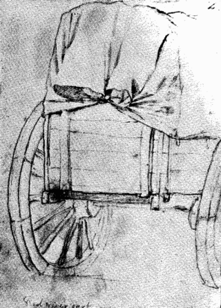
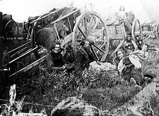
The Red River cart is a large two-wheeled cart made entirely of non-metallic materials. Often drawn by oxen, though also by horses or mules, these carts were used throughout most of the 19th century in the fur trade and in westward expansion in Canada and the United States, in the area of the Red River and on the plains west of the Red River Colony. The cart is a simple conveyance developed by Métis for use in their settlement on the Red River in what later became Manitoba. With carts, the Metis were not restricted to river travel to hunt bison. The Red River cart was largely responsible for commercializing the buffalo hunt.

Fort Victoria, near present-day Smoky Lake, Alberta, was established by the Hudson's Bay Company in 1864 on the North Saskatchewan River as a trading post with the local Cree First Nations. It had previously been settled in 1862 as a Methodist Missionary site, on the location of an aboriginal meeting place. It was named Victoria Settlement, after Queen Victoria.
Provincial Trunk Highway 3 is a major provincial highway located in the Canadian province of Manitoba. It runs from the Saskatchewan boundary to the southwest city limits of Winnipeg, where it continues as Winnipeg Route 155. Prior before to the implementation of Winnipeg's City Route System, it extended to Pembina Highway.

The North Saskatchewan River is a glacier-fed river that flows from the Canadian Rockies continental divide east to central Saskatchewan, where it joins with the South Saskatchewan River to make up the Saskatchewan River. Its water flows eventually into the Hudson Bay.
Fort Ellice was a Hudson's Bay Company trading post that operated from 1794 to 1892. It was first established in February 1794 by John Sutherland on the Qu'Appelle River about 20 kilometres (12 mi) upstream from its mouth at the Assiniboine River, and known as the Qu'Appelle River Post until it was destroyed by the North West Company in 1816.

Saskatchewan, the middle of Canada's three prairie provinces, has an area of 588,276.09 square kilometres (227,134.67 sq mi) and population of 1,150,632, mostly living in the southern half of the province.
The Red River Trails were a network of ox cart routes connecting the Red River Colony and Fort Garry in British North America with the head of navigation on the Mississippi River in the United States. These trade routes ran from the location of present-day Winnipeg in the Canadian province of Manitoba across the Canada–United States border, and thence by a variety of routes through what is now the eastern part of North Dakota and western and central Minnesota to Mendota and Saint Paul, Minnesota on the Mississippi.
Transportation in Saskatchewan includes an infrastructure system of roads, highways, freeways, airports, ferries, pipelines, trails, waterways, and railway systems serving a population of approximately 1,132,505 inhabitants year-round.

The Carlton Trail Railway is a shortline railway with its headquarters in Prince Albert, Saskatchewan. It is operated by OmniTRAX, an American transportation company in Denver, Colorado. Carlton Trail has been operating on ex-Canadian National track since December 8, 1997; however, after the acquisition of the branch line CTRW also purchased from CN the Birch Hills-Fenton-Prince Albert branch line in 2001. Since the closure of the pulp mill in 2006, Carlton Trail has typically adhered to a schedule of twice weekly rail service, hauling approximately 2000 carloads per year. According to OmniTrax president Darcy Brede, when the mill reopens in 2014, the railway will begin six days a week service, hauling approximately 3000 carloads a year.
Touchwood Hills are a range of hills in the Canadian province of Saskatchewan. The hills are composed of the "Big" Touchwood Hills and the Little Touchwood Hills. Together they are referred to as the Touchwood Uplands. The hills are in the Prairie Pothole Region of North America, which extends throughout three Canadian provinces and five U.S. states, and within Palliser's Triangle and the Great Plains ecoregion of Canada.
Touchwood Hills Post Provincial Park is the location of a former Hudson's Bay Company (HBC) fur trading post that existed from 1879 to 1909 in the Touchwood Uplands of the Canadian province of Saskatchewan. In 1986, the site was designated a provincial park. It is located along Highway 15 in the RM of Kellross No. 247, about 10 kilometres (6.2 mi) west of Lestock and 16 kilometres (9.9 mi) east of Punnichy.
Victoria Trail is an arterial road in northeast Edmonton, Alberta. It begins at the Yellowhead Trail interchange, then travels north through a number of neighborhoods, and currently ends at 153 Avenue.
Fort Road and Manning Drive is a major arterial road in Edmonton, Alberta, Canada. It is a major route in connecting Edmonton and Fort Saskatchewan formed on the west side of the Canadian National Railway line that itself formerly connected the two cities. Fort Road formerly connected Edmonton and Fort Saskatchewan in its entirety and was part of Alberta Highway 15; however the section north of 137 Avenue was bypassed and named Manning Drive. Fort Road gets its name for its connection to Fort Saskatchewan, while Manning Drive is after Ernest Manning, the premier of Alberta from 1943 to 1968.
Carlton is an unincorporated place in Rosthern Rural Municipality No. 403, Saskatchewan, Canada. The place is located on Highway 683, approximately 20 km north-west of Rosthern.

This article covers the water based Canadian canoe routes used by early explorers of Canada with special emphasis on the fur trade.

Katepwa Lake is a recreational lake in the Qu’appelle Valley in the Canadian province of Saskatchewan. The lake's name likely originated from the Cree word Kahtapwao, which means "What is calling?" Katepwa Lake is eastern most and farthest downstream of four lakes along the Qu'Appelle River known as the Fishing Lakes. Highway 56 runs along the eastern and southern shore and Highway 619 runs along the south-eastern shore.

Saskatchewan River fur trade The Saskatchewan River was one of the two main axes of Canadian expansion west of Lake Winnipeg. The other and more important one was northwest to the Athabasca Country. For background see Canadian canoe routes (early). The main trade route followed the North Saskatchewan River and Saskatchewan River, which were just south of the forested beaver country. The South Saskatchewan River was a prairie river with few furs.
Fur trading on the Assiniboine River and the general area west of Lake Winnipeg, in what is now Manitoba, Canada, began as early as 1731.

