The Winnipeg River is a Canadian river that flows roughly northwest from Lake of the Woods in the province of Ontario to Lake Winnipeg in Manitoba. This river is 235 kilometres (146 mi) long from the Norman Dam in Kenora to its mouth at Lake Winnipeg. Its watershed is 106,500 square kilometres (41,100 sq mi) in area, mainly in Canada. About 29,000 square kilometres (11,000 sq mi) of the watershed is in northern Minnesota, United States.

Cumberland House is a community in Census Division No. 18 in northeast Saskatchewan, Canada on the Saskatchewan River. It is the oldest community in Saskatchewan and has a population of about 2,000 people. Cumberland House Provincial Park, which provides tours of an 1890s powder house built by the Hudson's Bay Company, is located nearby.
Fort Assiniboine is a hamlet in northwest Alberta, Canada, within Woodlands County. It is located along the north shore of the Athabasca River at the junction of Highway 33 and Highway 661. It is approximately 39 kilometres (24 mi) northwest of Barrhead, 62 kilometres (39 mi) southeast of Swan Hills and 91 kilometres (57 mi) northeast of Whitecourt.
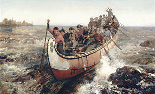
Fur brigades were convoys of canoes and boats used to transport supplies, trading goods and furs in the North American fur trade industry. Much of it consisted of native fur trappers, most of whom were Métis, and fur traders who traveled between their home trading posts and a larger Hudson's Bay Company or Northwest Company post in order to supply the inland post with goods and supply the coastal post with furs.
Fort Espérance was a North West Company trading post near Rocanville, Saskatchewan from 1787 until 1819. It was moved three times and was called Fort John from 1814 to 1816. There was a competing XY Company post from 1801 to 1805 and a Hudson's Bay post nearby from 1813 to 1816. It was on the Qu'Appelle River about 20 km from that river's junction with the Assiniboine River and about 7 km west of the Manitoba border. It was on the prairie in buffalo country and was mainly used as a source of pemmican which was sent down the river to Fort Bas de la Rivière at the mouth of the Winnipeg River.

Fort La Reine was built in 1738 and is one of the forts of the western expansion directed by Pierre Gaultier de Varennes et de La Vérendrye, first military commander in the west of what is now known as Canada. Located on the Assiniboine River where present day Portage la Prairie, Manitoba, stands, the fort served as a fur trading post. It was also the base of operations for much exploration north and west. From Fort La Reine, explorers made their way to Lake Manitoba and Lake Winnipegosis, Lake Winnipeg and the Saskatchewan River.

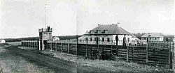
Fort Carlton was a Hudson's Bay Company fur trading post from 1795 until 1885. It was located along the North Saskatchewan River not far from Duck Lake. It is in the Canadian province of Saskatchewan and was rebuilt by the government of Saskatchewan as a feature of a provincial historic park and can be visited today. It is about 65 kilometres north of Saskatoon.
Fort Ellice was a Hudson's Bay Company trading post that operated from 1794 to 1892. It was first established in February 1794 by John Sutherland on the Qu'Appelle River about 20 kilometres (12 mi) upstream from its mouth at the Assiniboine River, and known as the Qu'Appelle River Post until it was destroyed by the North West Company in 1816.
Touchwood Hills Post Provincial Park is the location of a former Hudson's Bay Company (HBC) fur trading post that existed from 1879 to 1909 in the Touchwood Uplands of the Canadian province of Saskatchewan. In 1986, the site was designated a provincial park. It is located along Highway 15 in the RM of Kellross No. 247, 10 kilometres west of Lestock and 16 kilometres east of Punnichy.
Bas de la Rivière is a geographical area on both sides of the Winnipeg River at and near the mouth where it empties into Lake Winnipeg. It had a storied historical period in the opening of the west and the subsequent fur trade and settlement.

This article covers the water based Canadian canoe routes used by early explorers of Canada with special emphasis on the fur trade.

Saskatchewan River fur trade The Saskatchewan River was one of the two main axes of Canadian expansion west of Lake Winnipeg. The other and more important one was northwest to the Athabasca Country. For background see Canadian canoe routes (early). The main trade route followed the North Saskatchewan River and Saskatchewan River, which were just south of the forested beaver country. The South Saskatchewan River was a prairie river with few furs.
Brandon House was a Hudson's Bay Company post or posts from 1793 to 1824. It was located at several places on the Assiniboine River between Brandon, Manitoba and the mouth of the Souris River about 21 miles southeast of Brandon. Because of its location near the Souris River it was a center for trade with the Mandans in North Dakota. It was moved four times and there were related forts nearby, so its history is necessarily complex. For background see Assiniboine River fur trade.
Fur trading on the Assiniboine River and the general area west of Lake Winnipeg began as early as 1731.
Joseph Smith was a British fur trader and explorer working for the Hudson's Bay Company. He was one of the first Europeans to explore the interior of what later became Canada from Hudson Bay. Smith died June 1765 en route to York Factory from the Saskatchewan River country. Smith's explorations played an important role in opening up the interior of western Canada to European trade, and his journals provide one of the earliest accounts of Cree life.

The Athabasca Landing Trail was a long-distance portage route that linked Fort Edmonton on the North Saskatchewan River with Athabasca Landing on the Athabasca River. The distance of the trail between Fort Edmonton and Athabasca Landing was 100 miles (160 km), giving the trail the nickname "The 100 Mile Portage."
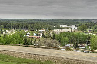
Hudson Bay Regional Park is a regional park in the Canadian province of Saskatchewan. It is located on the south side of the town of Hudson Bay in the RM of Hudson Bay No. 394 along the shores of the Red Deer River. The park is the site of a North West Company fur trading fort called Fort Red Deer River that was built in 1790. About 14 kilometres (8.7 mi) downstream, near Erwood, was a Hudson's Bay Company trading post that was built in 1757.

Etomami River is a river in the Canadian province of Saskatchewan. The river originates in the Porcupine Hills and flows northward towards the town of Hudson Bay and into the Red Deer River. "Etomami" is a First Nations word that means "a place that three rivers join." It is in reference to the spot along the Red Deer River where the mouths of the Etomami and Fir Rivers meet the Red Deer River.
Cumberland Island, also known as Pine Island, is a small island in the Saskatchewan River Delta in the east-central region of the Canadian province of Saskatchewan. The Saskatchewan River Delta is one of the largest active inland deltas in North America. Cumberland Island is situated between Cumberland Lake to the north and the Saskatchewan River to the south. The Tearing River runs along the eastern edge of the island and Bigstone River along the western edge. The Bigstone River separates Cumberland Island from Spruce Island to the west. The island is in the Mid-Boreal Lowland region, which consists of mixed coniferous and deciduous forests of white and black spruce, jack pine, tamarack, trembling aspen, balsam poplar, and balsam fir.