Arizona City is an unincorporated census-designated place (CDP) in southwestern Pinal County, Arizona, United States. It is located near the junction of Interstate 8 and Interstate 10 at the midpoint between Phoenix and Tucson, approximately 60 miles (97 km) from the downtown of both cities. The population was 10,475 as of the 2010 U.S. Census. It is estimated to be approximately 11,030 as of a 2017 U.S. Census estimate. Arizona City is a rural, primarily residential community that features a 48-acre man-made lake which has an HOA and is private to residents of surrounding homes only. These attributes make the community a popular snowbird destination, with the population increasing by as much as 5,000 people in the winter months to reach the census figure of 11,030. Most recently after the last Census, many full-time residents have relocated to the unincorporate town.

Casa Grande is a city in Pinal County, approximately halfway between Phoenix and Tucson in the U.S. state of Arizona. According to U.S. Census estimates, the population of the city is 55,653 as of 2020. It is named after the Casa Grande Ruins National Monument, which is actually located in Coolidge. "Casa Grande" is Spanish for "big house". Among resident English speakers, there is no consensus on how to pronounce the city's name.

Imagery intelligence (IMINT), pronounced as either as Im-Int or I-Mint, is an intelligence gathering discipline wherein imagery is analyzed to identify information of intelligence value. Imagery used for defense intelligence purposes is generally collected via satellite imagery or aerial photography.

Cold War espionage describes the intelligence gathering activities during the Cold War between the Western allies and the Eastern Bloc. Both relied on a wide variety of military and civilian agencies in this pursuit.

The Corona program was a series of American strategic reconnaissance satellites produced and operated by the Central Intelligence Agency (CIA) Directorate of Science & Technology with substantial assistance from the U.S. Air Force. The CORONA satellites were used for photographic surveillance of the Soviet Union (USSR), China, and other areas beginning in June 1959 and ending in May 1972.

Aerial photography is the taking of photographs from an aircraft or other airborne platforms. When taking motion pictures, it is also known as aerial videography.

Motion capture is the process of recording the movement of objects or people. It is used in military, entertainment, sports, medical applications, and for validation of computer vision and robots. In filmmaking and video game development, it refers to recording actions of human actors and using that information to animate digital character models in 2D or 3D computer animation. When it includes face and fingers or captures subtle expressions, it is often referred to as performance capture. In many fields, motion capture is sometimes called motion tracking, but in filmmaking and games, motion tracking usually refers more to match moving.

Photogrammetry is the science and technology of obtaining reliable information about physical objects and the environment through the process of recording, measuring and interpreting photographic images and patterns of electromagnetic radiant imagery and other phenomena.
Aerial archaeology is the study of archaeological remains by examining them from a higher altitude. In present day, this is usually achieved by satellite images or through the use of drones.

Aerial survey is a method of collecting geomatics or other imagery by using airplanes, helicopters, UAVs, balloons or other aerial methods. Typical types of data collected include aerial photography, Lidar, remote sensing and also geophysical data (such as aeromagnetic surveys and gravity. It can also refer to the chart or map made by analysing a region from the air. Aerial survey should be distinguished from satellite imagery technologies because of its better resolution, quality and atmospheric conditions. Today, aerial survey is sometimes recognized as a synonym for aerophotogrammetry, part of photogrammetry where the camera is placed in the air. Measurements on aerial images are provided by photogrammetric technologies and methods.
The aim of color calibration is to measure and/or adjust the color response of a device to a known state. In International Color Consortium (ICC) terms, this is the basis for an additional color characterization of the device and later profiling. In non-ICC workflows, calibration sometimes refers to establishing a known relationship to a standard color space in one go. The device that is to be calibrated is sometimes known as a calibration source; the color space that serves as a standard is sometimes known as a calibration target. Color calibration is a requirement for all devices taking an active part in a color-managed workflow and is used by many industries, such as television production, gaming, photography, engineering, chemistry, medicine, and more.
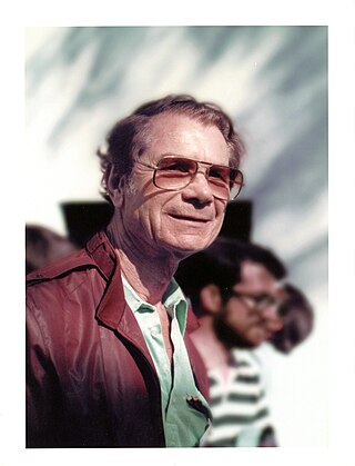
Merton E. Davies was a pioneer of America's space program, first in earth reconnaissance and later in planetary exploration and mapping. He graduated from Stanford University in 1938 and worked for the Douglas Aircraft corporation in the 1940s. He worked as a member of RAND Corporation after it split off from Douglas in 1948 and for the remainder of his career.

KH-9, commonly known as Big Bird or KeyHole-9, was a series of photographic reconnaissance satellites launched by the United States between 1971 and 1986. Of twenty launch attempts by the National Reconnaissance Office, all but one were successful. Photographic film aboard the KH-9 was sent back to Earth in recoverable film return capsules for processing and interpretation. The highest ground resolution achieved by the main cameras of the satellite was 2 ft (0.61 m). Another source says "images in the "better-than-one-foot" category" for the last "Gambit" missions.

Itek Corporation was a United States defense contractor that initially specialized in camera systems for spy satellites and various other reconnaissance systems. In the early 1960s they built a conglomerate in a fashion similar to LTV or Litton, during which time they developed the first CAD system and explored optical disc technology. These efforts were unsuccessful, and the company shed divisions to various companies, returning to its roots in the reconnaissance market. The remaining portions were eventually purchased by Litton in 1983, and then Hughes, Raytheon, and Goodrich Corporation.

Discoverer 14, also known as Corona 9009, was a spy satellite used in the Corona program managed by Advanced Research Projects Agency (ARPA) of the Department of Defense and the United States Air Force. On 19 August 1960, usable photographic film images of the Soviet Union taken by the satellite were recovered by a C-119 recovery aircraft. This was the first successful recovery of film from an orbiting satellite and the first mid-air recovery of an object returning from Earth orbit.

Image color transfer is a function that maps (transforms) the colors of one (source) image to the colors of another (target) image. A color mapping may be referred to as the algorithm that results in the mapping function or the algorithm that transforms the image colors. The image modification process is sometimes called color transfer or, when grayscale images are involved, brightness transfer function (BTF); it may also be called photometric camera calibration or radiometric camera calibration.
A3 Digital Mapping System consists of a digital airborne camera and an automatic ground processing system produced by VisionMap. The A3 camera captures imagery using a sweep mechanism, which collects high resolution vertical and oblique imagery simultaneously. The captured data is post-processed by the A3 LightSpeed ground processing system in order to create the final output products. The A3 System is used by numerous national and regional mapping agencies, as well as commercial mapping firms.

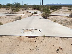
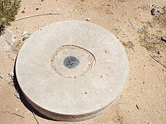
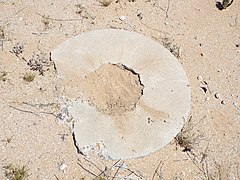
The Air Force Special Projects Production Facility was a top-secret facility operational at Westover Air Force Base from 1961 to 1976. It was responsible for developing film from the Corona satellite program and other film projects that were top secret. The facility was co-located with the 8th Reconnaissance Technical Squadron and developed the film used during the Cuban Missile Crisis. It was also the primary production facility for the National Reconnaissance Program during this time. The facility was also in charge of the Controlled Range Network, which served to calibrate Corona, Gambit, and Hexagon satellite programs.
Radar calibration satellites are orbital satellites used to calibrate ground-based space surveillance radars. There are two types: active and passive.