Casa Grande, Arizona

Last updated

Casa Grande
O'odham: Wainom Wo:g
Casa Grande-Casa Grande Union High School-1920-2.jpg
Historic Casa Grande Union High School which now serves as the Casa Grande City Hall.
Flag of Casa Grande, Arizona.gif
Pinal County Arizona Incorporated and Unincorporated areas Casa Grande Highlighted 0410530.svg
Location of Casa Grande in Pinal County, Arizona.
Usa edcp location map.svg
Red pog.svg
Casa Grande
Location in the United States
Coordinates: 32°53′9″N111°44′38″W / 32.88583°N 111.74389°W / 32.88583; -111.74389
Country United States
State Arizona
County Pinal
Founded1879
Government
  MayorCraig McFarland 
  City CouncilMatt Herman,
Lisa Navarro Fitzgibbons,
Donna McBride,
Bob Huddleston,
Jeff Lavender,
Anthony Edwards
Area
[1]
  Total112.01 sq mi (290.10 km2)
  Land112.01 sq mi (290.10 km2)
  Water0.00 sq mi (0.00 km2)
Elevation
[2]
1,381 ft (421 m)
Population
 (2020)
  Total53,658
  Density479.06/sq mi (184.96/km2)
Time zone UTC−7 (MST (no DST))
ZIP codes
85122, 85194, 85130, 85193
Area code 520
FIPS code 04-10530
GNIS feature ID2409401 [2]
Website http://www.casagrandeaz.gov

Casa Grande (O'odham: Wainom Wo:g) is a city in Pinal County, approximately halfway between Phoenix and Tucson in the U.S. state of Arizona. According to U.S. Census estimates, the population of the city is 55,653 as of 2020. [3] It is named after the Casa Grande Ruins National Monument, which is actually located in Coolidge. "Casa Grande" is Spanish for "big house". Among resident English speakers, there is no consensus on how to pronounce the city's name. [4]

Contents

History

Casa Grande was founded in 1879 during the Arizona mining boom, specifically due to the presence of the Southern Pacific Railroad. In January 1880, the community of Terminus, meaning "end-of-the-line," was established despite consisting of just five residents and three buildings. [5] In September 1880, railroad executives renamed the settlement Casa Grande, after the Hohokam ruins at the nearby Casa Grande Ruins National Monument. Casa Grande grew slowly, and suffered several setbacks both in 1886 and 1893, when fires ravaged the town, destroying all wooden housing structures within it. [5] When the mining boom slowed in the 1890s, the town was nearly abandoned, but with the advent of agriculture, the town remained alive and well, and was eventually incorporated in 1915. [5]

One of the founding fathers of Casa Grande was Thompson Rodney Peart. Peart Road, Peart Park, and the Peart Center, all of which are notable fixtures of Casa Grande, are named after him.

Casa Grande was home to a collective farm society which was part of the Farm Security Administration.

From 1942 to 1945, a Japanese-American relocation camp was set up outside of Casa Grande, known as the Gila River War Relocation Center. Two notable people that were interned there were future actor Pat Morita and baseball player Kenichi Zenimura, who constructed a baseball field and set up a league in the relocation camp. [6]

Casa Grande is home to Francisco Grande Hotel & Golf Resort, former spring training location for the San Francisco Giants. Then owner, Horace Stoneham, began developing the property in 1959. The first exhibition game was played in Casa Grande in 1961, with Willie Mays hitting a 375-foot (114 m) home run. The San Francisco Giants no longer play at Francisco Grande, but the pool in a baseball bat and ball shape remains in memory of the past ballgames. [7]

During the Cold War, Casa Grande was the location of the Casa Grande Photogrammetric Test Range. These targets consisted of concrete arrows located in and to the south of the city, which calibrated aerial cartographic cameras. [8]

Casa Grande has also played a prominent role in semi-pro and collegiate baseball. The Casa Grande Cotton Kings, who were founded in 1948, qualified to play in the National Baseball Congress World Series ten straight times by winning Arizona state championships in the 1940s and 1950s, and were reactivated in the 2000s. They are now members of the Pacific Southwest Baseball League. [9]

Geography

According to the United States Census Bureau, Casa Grande has a total area of 112.01 square miles (290.1 km2), all land. [10]

Climate

Casa Grande has a hot desert climate (Köppen climate classification BWh), typical for the Sonoran Desert. The city experiences long, extremely hot summers and brief winters consisting of mild afternoons and chilly evenings. Along with the rest of southern Arizona, the community is prone to dust storms and in the summer months is affected by the North American Monsoon, which brings high winds and heavy rain.[ citation needed ]

Climate data for Casa Grande, Arizona, 19912020 normals, extremes 1908present
MonthJanFebMarAprMayJunJulAugSepOctNovDecYear
Record high °F (°C)89
(32)
93
(34)
100
(38)
106
(41)
116
(47)
123
(51)
123
(51)
120
(49)
115
(46)
111
(44)
97
(36)
89
(32)
123
(51)
Mean maximum °F (°C)78.8
(26.0)
82.7
(28.2)
90.8
(32.7)
99.2
(37.3)
106.8
(41.6)
113.9
(45.5)
114.8
(46.0)
113.1
(45.1)
108.9
(42.7)
102.0
(38.9)
89.9
(32.2)
79.1
(26.2)
116.1
(46.7)
Mean daily maximum °F (°C)68.7
(20.4)
72.6
(22.6)
79.9
(26.6)
87.5
(30.8)
96.4
(35.8)
105.8
(41.0)
106.8
(41.6)
105.3
(40.7)
100.4
(38.0)
90.7
(32.6)
77.5
(25.3)
67.6
(19.8)
88.3
(31.3)
Daily mean °F (°C)53.9
(12.2)
57.0
(13.9)
63.6
(17.6)
70.3
(21.3)
78.4
(25.8)
87.9
(31.1)
92.5
(33.6)
91.3
(32.9)
85.5
(29.7)
73.8
(23.2)
61.4
(16.3)
53.0
(11.7)
72.4
(22.4)
Mean daily minimum °F (°C)39.1
(3.9)
41.5
(5.3)
47.2
(8.4)
53.0
(11.7)
60.4
(15.8)
69.9
(21.1)
78.1
(25.6)
77.3
(25.2)
70.7
(21.5)
56.9
(13.8)
45.3
(7.4)
38.4
(3.6)
56.5
(13.6)
Mean minimum °F (°C)26.1
(−3.3)
29.0
(−1.7)
33.6
(0.9)
38.5
(3.6)
46.5
(8.1)
56.3
(13.5)
66.5
(19.2)
66.7
(19.3)
56.6
(13.7)
42.7
(5.9)
29.1
(−1.6)
25.7
(−3.5)
23.0
(−5.0)
Record low °F (°C)8
(−13)
11
(−12)
21
(−6)
25
(−4)
32
(0)
44
(7)
51
(11)
55
(13)
37
(3)
25
(−4)
17
(−8)
14
(−10)
8
(−13)
Average precipitation inches (mm)0.79
(20)
1.00
(25)
0.76
(19)
0.21
(5.3)
0.18
(4.6)
0.18
(4.6)
0.91
(23)
1.52
(39)
0.72
(18)
0.48
(12)
0.43
(11)
0.73
(19)
7.91
(201)
Average precipitation days (≥ 0.01 in)3.53.93.31.21.30.72.94.52.51.91.93.831.4
Source 1: NOAA [11]
Source 2: National Weather Service [12]

Demographics

Historical population
CensusPop.Note
1880 33
1890 328893.9%
1920 948
1930 1,35142.5%
1940 1,54514.4%
1950 4,181170.6%
1960 8,31198.8%
1970 10,53626.8%
1980 14,97142.1%
1990 19,07627.4%
2000 25,22432.2%
2010 48,57192.6%
2020 53,65810.5%
2022 (est.)60,032 [13] 11.9%
U.S. Decennial Census [14]

As of the census of 2010, there were 48,571 people, 22,400 households, and 6,547 families residing in the city. The population density was 523.7 inhabitants per square mile (202.2/km2). There were 11,041 housing units at an average density of 229.2 per square mile (88.5/km2). The racial makeup of the city was 49.9% non-Hispanic White, 4.27% Black or African American, 4.91% Native American, 1.17% Asian, 0.10% Pacific Islander, 21.09% from other races, and 3.56% from two or more races. 39.13% of the population were Hispanic or Latino of any race.

There were 8,920 households, out of which 37.1% had children under the age of 18 living with them, 52.3% were married couples living together, 15.1% had a female householder with no husband present, and 26.6% were non-families. 21.7% of all households were made up of individuals, and 8.9% had someone living alone who was 65 years of age or older. The average household size was 2.80 and the average family size was 3.24.

In the city, the population was spread out, with 30.9% under the age of 18, 9.3% from 18 to 24, 26.4% from 25 to 44, 19.6% from 45 to 64, and 13.8% who were 65 years of age or older. The median age was 32 years. For every 100 females, there were 97.1 males. For every 100 females age 18 and over, there were 91.5 males.

The median income for a household in the city was $36,212, and the median income for a family was $40,827. Males had a median income of $34,858 versus $23,533 for females. The per capita income for the city was $15,917. About 12.4% of families and 16.0% of the population were below the poverty line, including 21.2% of those under age 18 and 12.3% of those age 65 or over.

Economy

The historic Southern Pacific Railroad Depot was built in 1925 and is located at 201 W. Main St. Casa Grande-Southern Pacific Railroad Depot-1925.JPG
The historic Southern Pacific Railroad Depot was built in 1925 and is located at 201 W. Main St.

The economy of Casa Grande was historically based on rural, agricultural industries, such as cotton and dairy farms. Over time, the city has become home to many Phoenix or Tucson urbanites who own homes in Casa Grande. Most residents either commute north to work in the Phoenix metropolitan area, or to the south, to work in Tucson. This trend has contributed to growth in the service industry of Casa Grande. Many new businesses such as restaurants, gas stations, and retail outlets are opening throughout the city in order to keep up with demand from the growing population.

A retail shopping mall operates in southern Casa Grande. Phase one of The Promenade at Casa Grande opened on November 16, 2007. Built by Westcor and the Pederson Group, it is similar to Desert Ridge Marketplace (an outdoor shopping center in northeast Phoenix). The Promenade at Casa Grande is an outdoor mall, built on a 100-acre (0.40 km2) patch of desert, and contains nearly a million square feet. An additional $11 million was spent by the city to fund the reconstruction of the Florence Blvd./I-10 freeway overpass.

Ehrmann Commonwealth Dairy operates a major dairy processing facility in the town that opened in 2013 and employs about 110 people. [15]

Top Employers

According to Casa Grande's 2020 Comprehensive Annual Financial Report, [16] the top employers in the city are:

#Employer# of Employees
1 Casa Grande Elementary School District 957
2 Walmart Distribution Center848
3 Hexcel Corporation 626
4 Banner Casa Grande Medical Center625
5 U.S. Customs and Border Protection - Casa Grande Station500
6 Abbott Laboratories/Ross Products 450
7City of Casa Grande433
8 Tractor Supply Company Distribution Center322
9 Casa Grande Union High School District 318
10 Frito-Lay, Inc. 300
10 Fry's Food and Drug 300

Electric Cars

On November 29, 2016, officials from the state and the Lucid Motors car company announced a $700 million manufacturing plant would be constructed in Casa Grande that would employ up to 2,000 workers by 2022. [17] [18] [19] The Lucid car manufacturing plant opened in November 2020.

News

Fire Department

The Casa Grande Fire Department (CGFD), ISO Class 2, provides fire protection and emergency medical services to the City of Casa Grande. The Casa Grande Fire Department operates out of 4 Fire Stations and an Administrative Headquarters at the Public Safety Building.

CGFD is serving 109.65 square miles with over 60,000 residents.

Dave Kean is the Fire Chief for the City of Casa Grande. In 2021-22 Chief Kean led the fight for the City to form their own ambulance transportation service and obtain a “Certificate of Necessity” from the Arizona Department of Health. This allowed the CGFD to expand by 26 members. Just prior to that he had added a full-time Ladder company (12 new firefighters) to the Department.

In 2023, Chief Kean got funding for a new Fire Station 503 at a cost over $13.4 million dollars. This is the first new fire facility in over 14 years.

Library

The Casa Grande Public Library provides the standard services of access to reading materials, as well as some special services, including a volunteer reading club for elementary school, internet access, and a talking book program. The main library is 16,000 square feet (1,500 m2), provides 75,000 volumes, and provides 38 public access computers with internet access. The Vista Grande Public Library, a branch of the Casa Grande Library System, opened in the summer of 2009. [20] [21]

City Court

The Casa Grande Municipal Court is the judicial branch of Casa Grande City government and accepted 6,609 filings, conducted 2,486 arraignments and held 156 civil, criminal and jury trials in Fiscal Year 2006–2007. [22]

Notable people

Education

Most of Casa Grande is in the Casa Grande Elementary School District, while a portion is in the Toltec Elementary School District. All of Casa Grande is in the Casa Grande Union High School District. [24]

The following schools are located in Casa Grande.

Transportation

These highways serve Casa Grande.

The City of Coolidge operates Central Arizona Regional Transit (CART), which provides transportation between Florence, Coolidge, Central Arizona College and Casa Grande. [25] Greyhound serves Casa Grande from a stop in Eloy.

The closest major airports to Casa Grande are Phoenix Sky Harbor International Airport and Tucson International Airport. Casa Grande Shuttle provides an airport shuttle to Sky Harbor. [26]

See also

Related Research Articles

<span class="mw-page-title-main">Pima County, Arizona</span> County in Arizona, United States

Pima County is a county in the south central region of the U.S. state of Arizona. As of the 2020 census, the population was 1,043,433, making it Arizona's second-most populous county. The county seat is Tucson, where most of the population is centered. The county is named after the Pima Native Americans, also known as Tohono O'odham, who are indigenous to this area.

<span class="mw-page-title-main">Pinal County, Arizona</span> County in Arizona, United States

Pinal County is in the central part of the U.S. state of Arizona. According to the 2020 census, the population of the county was 425,264, making it Arizona's third-most populous county. The county seat is Florence. The county was founded in 1875.

<span class="mw-page-title-main">Yuma County, Arizona</span> County in Arizona, United States

Yuma County is a county in the southwestern corner of the U.S. state of Arizona. As of the 2020 census, its population was 203,881. The county seat is Yuma.

<span class="mw-page-title-main">Springerville, Arizona</span> Town in Apache County, Arizona, United States

Springerville is a town in Apache County, Arizona, United States, within the White Mountains. Its postal ZIP Code is 85938. As of the 2010 census, the population of the town was 1,961.

<span class="mw-page-title-main">Safford, Arizona</span> City in Arizona, United States

Safford is a city in Graham County, Arizona, United States. According to the 2020 Census, the population of the city is 10,129. The city is the county seat of Graham County.

<span class="mw-page-title-main">Avondale, Arizona</span> City in Arizona, United States

Avondale is a city in Maricopa County, Arizona, United States, adjacent to Phoenix. As of the 2020 census, the population of the city was 89,334, up from 76,238 in 2010 and 35,883 in 2000.

<span class="mw-page-title-main">Gilbert, Arizona</span> Town in Maricopa County, Arizona

Gilbert is a town in Maricopa County, Arizona, United States, located southeast of Phoenix within the city's metropolitan area. Incorporated on July 6, 1920, Gilbert was once known as the "Hay Shipping Capital of the World". The population was 267,918 at the 2020 census, and was estimated to be 275,346 in 2022. It is the fifth-largest municipality in Arizona, and the fourth-largest in the Phoenix metro area. It covers an area of nearly 69 square miles (179 km2).

<span class="mw-page-title-main">Goodyear, Arizona</span> City in Arizona, United States

Goodyear is a city in Maricopa County, Arizona, United States. It is a suburb of Phoenix and at the 2020 census had a population of 95,294, up from 65,275 in 2010 and 18,911 in 2000. It was the third-fastest-growing city in Arizona between 1990 and 2000.

<span class="mw-page-title-main">Peoria, Arizona</span> City in Arizona, United States

Peoria is a city in Maricopa and Yavapai counties in the U.S. state of Arizona. Most of the city is located in Maricopa County, while a portion of it in the north is in Yavapai County. It is a major suburb of Phoenix. As of the 2020 census, the population of Peoria was 190,985, up from 154,065 in 2010. It is the sixth-largest city in Arizona in land area and the ninth-largest in population. It was named after Peoria, Illinois. The word peoria is a corruption of the Miami-Illinois word for "prairie fire". It is the spring training home of the San Diego Padres and Seattle Mariners, who share the Peoria Sports Complex.

<span class="mw-page-title-main">Casas Adobes, Arizona</span> CDP in Pima County, Arizona

Casas Adobes is an unincorporated community and census-designated place (CDP) located in the northern metropolitan area of Tucson, Arizona. The population was 66,795 at the 2010 census. Casas Adobes is situated south and southwest of the town of Oro Valley, and west of the community of Catalina Foothills.

<span class="mw-page-title-main">Oro Valley, Arizona</span> Town in Pima County, Arizona

Oro Valley, incorporated in 1974, is a suburban town located 6 miles (9.7 km) north of Tucson, Arizona, United States, in Pima County. According to the 2020 census, the population of the town is 47,070, an increase from 29,700 in 2000. Dubbed the "Upscale Tech Mecca" of Southern Arizona by the Arizona Daily Star newspaper, Oro Valley is home to over 10 high tech firms and has a median household income nearly 50% higher than the U.S. median. The town is located approximately 110 miles (180 km) southeast of the state capital of Phoenix.

<span class="mw-page-title-main">Arizona City, Arizona</span> CDP in Pinal County, Arizona

Arizona City is an unincorporated census-designated place (CDP) in southwestern Pinal County, Arizona, United States. It is located near the junction of Interstate 8 and Interstate 10 at the midpoint between Phoenix and Tucson, approximately 60 miles (97 km) from the downtown of both cities. The population was 10,475 as of the 2010 U.S. Census. It is estimated to be approximately 11,030 as of a 2017 U.S. Census estimate. Arizona City is a rural, primarily residential community that features a 48-acre man-made lake which has an HOA and is private to residents of surrounding homes only. These attributes make the community a popular snowbird destination, with the population increasing by as much as 5,000 people in the winter months to reach the census figure of 11,030. Most recently after the last Census, many full-time residents have relocated to the unincorporate town.

<span class="mw-page-title-main">Coolidge, Arizona</span> City in Arizona, United States

Coolidge is a city in Pinal County, Arizona, United States. According to the 2020 census, the city's population is 13,218.

<span class="mw-page-title-main">Eloy, Arizona</span> City in Arizona, United States

Eloy is a city in Pinal County, Arizona, United States, approximately 50 miles (80 km) northwest of Tucson and about 65 miles (105 km) southeast of Phoenix. According to the U.S. Census estimates in 2020, the population of the city is 15,635.

<span class="mw-page-title-main">Florence, Arizona</span> Town in Pinal County, Arizona

Florence is a town in Pinal County, Arizona, United States. Florence, which is the county seat of Pinal County, is one of the oldest towns in that county and includes a National Historic District with over 25 buildings listed on the National Register of Historic Places. The population of Florence was 26,785 at the 2020 census.

<span class="mw-page-title-main">Maricopa, Arizona</span> City in Arizona, United States

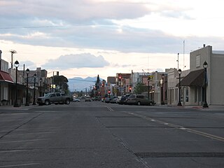
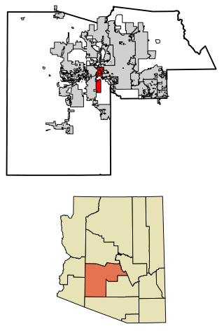
Maricopa is a city in the Gila River Valley in Pinal County, Arizona, United States. With 66,290 residents as of 2022, Maricopa is the largest incorporated municipality in Pinal County.

<span class="mw-page-title-main">Blythe, California</span> City in California, United States

Blythe is a city in eastern Riverside County, California, United States. It is in the Palo Verde Valley of the Lower Colorado River Valley region, an agricultural area and part of the Colorado Desert along the Colorado River, approximately 224 miles (360 km) east of Los Angeles and 150 miles (240 km) west of Phoenix. Blythe was named after Thomas Henry Blythe, a San Francisco financier, who established primary water rights to the Colorado River in the region in 1877. The city was incorporated on July 21, 1916. The population was 18,317 at the 2020 census.

<span class="mw-page-title-main">Winchester, Oklahoma</span> Town in Oklahoma, United States

Winchester is a town in Okmulgee County, Oklahoma, United States. The population was 546 at the 2020 census, an increase of 5.8% from the figure of 516 recorded in 2010. It is a recently built residential community, having incorporated February 18, 1974.

<span class="mw-page-title-main">San Luis, Arizona</span> City in Arizona, United States

San Luis is a city in Yuma County, Arizona, United States. The population was 35,257 at the 2020 census. It is part of the Yuma Metropolitan Statistical Area. San Luis, located in the southwest corner of the state directly adjacent to Mexico's Federal Highway 2 at San Luis Rio Colorado, was the second fastest-growing city or town in Arizona from 1990 to 2000. According to 2022 Census Bureau estimates, the population of the city is 35,770.

<span class="mw-page-title-main">Timeline of Arizona</span> Timeline of the history of Arizona

The following is a timeline of the history of the area which today comprises the U.S. state of Arizona. Situated in the desert southwest, for millennia the area was home to a series of Pre-Columbian peoples. By 1 AD, the dominant groups in the area were the Hohokam, the Mogollon, and the Ancestral Puebloans. The Hohokam dominated the center of the area which is now Arizona, the Mogollon the southeast, and the Puebloans the north and northeast. As these cultures disappeared between 1000 and 1400 AD, other Indian groups settled in Arizona. These tribes included the Navajo, Apache, Southern Paiute, Hopi, Yavapai, Akimel O'odham, and the Tohono O'odham.

References

  1. "2020 U.S. Gazetteer Files". United States Census Bureau. Retrieved October 29, 2021.
  2. 1 2 U.S. Geological Survey Geographic Names Information System: Casa Grande, Arizona
  3. "U.S. Census website". United States Census Bureau . Retrieved June 19, 2014.
  4. "How You Say It Isn't Clear, Even if You're From Here". New York Times. Retrieved January 7, 2019.
  5. 1 2 3 "Casa Grande History" Archived July 1, 2015, at the Wayback Machine , retrieved September 10, 2013
  6. Leighton, David (March 2, 2015). "Street Smarts: Miracle Mile went to 'Big House'". Arizona Daily Star. Retrieved April 19, 2024.
  7. "The Birth of a Mecca, the Realization of a Dream" Archived June 20, 2018, at the Wayback Machine , retrieved September 10, 2013
  8. Hider, Anna (October 3, 2014). "What the heck are these abandoned cement targets in the Arizona desert?". Roadtrippers. Retrieved April 14, 2016.
  9. History – Casa Grande Cotton Kings, retrieved February 4, 2014
  10. "Departments: Fire". City of Casa Grande. Retrieved March 13, 2023.
  11. "U.S. Climate Normals Quick Access – Station: Casa Grande, AZ". National Oceanic and Atmospheric Administration. Retrieved March 29, 2023.
  12. "NOAA Online Weather Data – NWS Phoenix". National Weather Service. Retrieved March 29, 2023.
  13. "City and Town Population Totals: 2020-2022" . Retrieved April 14, 2024.
  14. "Census of Population and Housing". Census.gov. Retrieved June 4, 2016.
  15. "Ehrmann Commonwealth Dairy to open $50M Casa Grande plant". Phoenix Business Journal. October 17, 2013. Retrieved December 16, 2016.
  16. "City of Casa Grande - 6.30.2020 - CAFR.pdf". Google Docs.
  17. "Lucid Motors Has A 1000HP Tesla Challenger; Now To Find The Cash To Build It". Forbes. November 29, 2016. Retrieved November 30, 2016.
  18. Ronald J. Hansen and Yvonne Wingett Sanchez (November 30, 2016). "Tesla rival Lucid Motors plans Casa Grande plant". azcentral, The Republic. Retrieved November 30, 2016.
  19. FOX (November 29, 2016). "Electric car factory planned in Arizona to have 2,000 workers – Story | KSAZ". Fox10phoenix.com. Archived from the original on August 13, 2017. Retrieved February 17, 2017.
  20. Casa Grande Community Services Department – Library Archived September 21, 2013, at the Wayback Machine , retrieved September 11, 2013
  21. CG Library Notes, 8/18/09, retrieved September 11, 2013
  22. City of Casa Grande – City Court Archived March 23, 2008, at the Wayback Machine
  23. Yardley, William (September 13, 2012). "Pedro Guerrero, Who Captured Art in Photos, Dies at 95". The New York Times.
  24. "2020 CENSUS - SCHOOL DISTRICT REFERENCE MAP: Pinal County, AZ" (PDF). U.S. Census Bureau . Retrieved November 13, 2023.
  25. "Ride The Cart – Partnership in Motion" . Retrieved January 27, 2020.
  26. "Our Rates and Van Schedule | Casa Grande Shuttle" . Retrieved November 10, 2021.