History
Antebellum Years
Casa Blanca, formerly known to the Mexicans as La Tierra Amontonada (The Land Piled Up), named for the Hohokam ruin mound nearby, was one of the Pima Villages on the Gila River in what was then part of the state of Sonora, Mexico. [3] It was encountered by the American expedition of Stephen W. Kearny in 1846 and later by Americans on their way to California on the Southern Emigrant Trail during the California Gold Rush. Following the Gadsden Purchase the Pima Villages became part of New Mexico Territory. In 1857, the San Antonio-San Diego Mail Line passed through the village on the way between Maricopa Wells and Tucson.
In 1858 when Lieutenant A. B. Chapman, of the 1st Dragoons, took the first census of the Pimas and Maricopas, he found a Pima population of 535; 110 warriors, 425 women and children led by a Captain named Chelan at this village now named Casa Blanca. [4] The next year another official census was taken by the special Indian Agent that showed Casa Blanca had 491 Pimas, broken down as 50 Aged, 146 Men, 103 Women, 105 Boys, 87 Girls, led by Captain Candela. Also enumerated were 30 cattle and 46 horses. [5] The 1860 Census showed a total Pima population of 323 composed of 71 Male heads of household, 66 Female heads, 82 Male Children 87 female children and 17 Other males and females. [6] It also show they had 164 horses and 102 cattle and 59 farmers tilled 587 acres of improved land. [7]
Casa Blanca became the site of the Casa Blanca Station of the Butterfield Overland Mail in 1858. It was located about 4,200 feet west-northwest of the Casa Blanca ruin mound. [8]
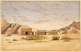
The station agent of Casa Blanca Station, Silas St. John, also became Special Agent for the Pima and Maricopa Indians on February 18, 1859, and later that year built the Indian Agency buildings for the Pima Villages in the village in 1859. These consisted of two buildings with a picket fence or corral between them. located about 3,500 feet northwest of the ruin mound at Casa Blanca and some 800 feet from the stage station. One, an adobe, was a blacksmith shop, the other of jacal construction, was a carpenter shop and agency office. [9]
In 1860, the census showed fifteen European Americans at Casa Blanca who were part of Ammi M. White's enterprise there. White, with his half-brother, Cyrus Lennan, and partner E.S. Noyes, established a trading post at Casa Blanca. White & Co. had taken over the buildings of St.John's Indian agency, (after his resignation from that post in late 1859), which included a blacksmith shop, run by Noyes. [9]
White's Mill and the Civil War
White's Mill was established at Casa Blanca in 1861 to turn the Pima's grain into flour. [10] At the beginning of the American Civil War, Ammi White began stockpiling flour and other food for the California Column at the mill, which became the target of a raid by the Arizona Rangers a Confederate Army detachment sent to occupy southern Arizona. Led by Captain Sherod Hunter, the raid destroyed the mill machinery, captured Ammi White and returned the flour and other food to the Pima. When Captain Hunter impersonated White and his men posed as locals, they also captured Union Army Captain William McCleave and his detachment who came to visit the mill.
Once the California Column arrived they found they had to wait to gather up flour and food to continue their march to Tucson and so they built Fort Barrett around the mill to protect their depot there. After the capture of Tucson the post was abandoned except as a post for vedettes and express riders. Ammi White was later exchanged, as the Confederate Army retreated from New Mexico Territory, returning to rebuild his mill which, with the increased production of the Pima farmers, helped to feed the Union Army and the local population of the territory during the rest of the war. After White sold the mill and moved away in 1867, it was destroyed in a flood in September 1868. Subsequently, the machinery was salvaged and moved to Adamsville. [11]

Pinal County is in the central part of the U.S. state of Arizona. According to the 2020 census, the population of the county was 425,264, making it Arizona's third-most populous county. The county seat is Florence. The county was founded in 1875.

Gila Bend, founded in 1872, is a town in Maricopa County, Arizona, United States. The town is named for an approximately 90-degree bend in the Gila River, which is near the community's current location. As of the 2020 census, the population of the town was 1,892.

Sacaton is a census-designated place (CDP) in Pinal County, Arizona, United States. The population was 3,254 at the 2020 census. It is the capital of the Gila River Indian Community.

The Gila River Indian Community (GRIC) is an Indian reservation in the U.S. state of Arizona, lying adjacent to the south side of the cities of Chandler and Phoenix, within the Phoenix Metropolitan Area in Pinal and Maricopa counties. The Gila River Indian Community was established in 1859, and the Gila River Indian Community was formally established by Congress in 1939. The community is home for members of both the Akimel O’odham (Pima) and the Pee-Posh (Maricopa) tribes.
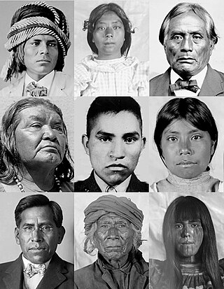
The Akimel O'odham, also called the Pima, are a group of Native Americans living in an area consisting of what is now central and southern Arizona, as well as northwestern Mexico in the states of Sonora and Chihuahua. The majority population of the two current bands of the Akimel O'odham in the United States are based in two reservations: the Keli Akimel Oʼodham on the Gila River Indian Community (GRIC) and the On'k Akimel O'odham on the Salt River Pima-Maricopa Indian Community (SRPMIC).

Gila River Indian Reservation was a reservation established in 1859 by the United States government in New Mexico Territory, to set aside the lands of the Akimel O’odham (Pima) and the Piipaash (Maricopa) people along the Gila River, in what is now Pinal County, Arizona. The self-government of the reservation as the Gila River Indian Community was established by Congress in 1939.
Fort Barrett was a temporary earthwork built by the United States Army's California Column in 1862 during the American Civil War. It was located in the Pima Villages two miles from the Gila River nearby Casa Blanca, New Mexico Territory and was built around the mill of settler Ammi M. White to protect it and provide a safe location to gather food and forage from the Pima people for the advance on Tucson. The fort was named after Lieutenant James Barrett who was killed in the Battle of Picacho Peak. Following the capture of Tucson in May the construction of the post ceased, and was abandoned, except as a post for vedettes and express riders.
Pima Villages, sometimes mistakenly called the Pimos Villages in the 19th century, were the Akimel O’odham (Pima) and Pee-Posh (Maricopa) villages in what is now the Gila River Indian Community in Pinal County, Arizona. First, recorded by Spanish explorers in the late 17th century as living on the south side of the Gila River, they were included in the Viceroyalty of New Spain, then in Provincias of Sonora, Ostimuri y Sinaloa or New Navarre to 1823. Then from 1824 to 1830, they were part of the Estado de Occidente of Mexico and from September 1830 they were part of the state of Sonora. These were the Pima villages encountered by American fur trappers, traders, soldiers and travelers along the middle Gila River from 1830s into the later 19th century. The Mexican Cession following the Mexican American War left them part of Mexico. The 1853 Gadsden Purchase made their lands part of the United States, Territory of New Mexico. During the American Civil War, they became part of the Territory of Arizona.
Sacaton or Socatoon was a village of the Maricopa people, established above the Pima Villages, after the June 1, 1857, in the Battle of Pima Butte where it appears a few months later in the 1857 Chapman Census. Sacaton village lay on the Gila River, 3.75 miles west of modern Sacaton.
Socatoon Station was a stagecoach station of the Butterfield Overland Mail between 1858 and 1861. It was located four miles (6.4 km) east of Sacaton at a Maricopa village from which it took its name. This station was located 22 miles (35 km) east of Maricopa Wells Station, 11 miles (18 km) east of Casa Blanca Station and 13 miles (21 km) north of Oneida Station.
Arenal, "sandy place" in Spanish, also known as Aranca No.1 in the 1857 census, was one of the 19th century Pima Villages, located along the Gila River, in what is now the Gila River Indian Community in Pinal County, Arizona.
Hormiguero, Spanish for "anthill",, one of the 19th century Pima Villages, was located along the Gila River, in what is now the Gila River Indian Community in Pinal County, Arizona.
El Llano, Spanish for "the plain or open space" or Buen Llano, "good plain", one of the 19th century Pima Villages, was located along the south side of the Gila River, between Sweetwater and Sacaton, in what is now the Gila River Indian Community in Pinal County, Arizona.
Hueso Parado, Spanish for “Standing Bone” or El Juez Tarado Spanish for "The Judge Tarado", was the largest village of the Maricopa people in the 19th century, in what is now the Gila River Indian Community in Pinal County, Arizona.
Agua Raiz, Spanish for "Water root" as named in the 1860 Census, it was one of the 19th century Pima Villages, located along the Gila River, near the modern site of Sacate Village, Arizona in what is now the Gila River Indian Community in Pinal County, Arizona.
Cienega of San Simon, was a cienega, an area of springs 13 miles up the San Simon River from San Simon Station, in Cochise County, Arizona.
Tres Alamos Wash, an ephemeral stream tributary to the San Pedro River, in Cochise County, Arizona. It runs southwesterly to meet the San Pedro River, across the river from the former settlement of Tres Alamos, Arizona. Tres Alamos Wash passes east and northeastward between the Little Dragoon Mountains and Johnny Lyon Hills to where it arises in a valley east of those heights and west of Allen Flat and the Steele Hills. It has its source at 32°07′45″N110°02′59″W.

Sacate Village is a census-designated place in Pinal County, in the U.S. state of Arizona. The population was 169 at the 2010 census.

Sacate is a populated place in the Middle Gila River Valley area, within Pinal County, Arizona, United States. Located 8 mi (13 km) north of Maricopa on the south side of the Gila River near Pima Butte, Sacate was an Pima village, a railroad station of the Southern Pacific Railroad, and a Catholic mission. It had originally been called Sacaton Station but the name was shortened to its current version in 1904.
Cachanillo, a derivative of Cachanilla in Spanish, being an arrowweed or Pluchea sericea, was one of the 19th century Pima Villages, located along the Gila River, in what is now the Gila River Indian Community in Pinal County, Arizona.


