
Mammoth is a town in Pinal County, Arizona, United States. The population was 1,426 at the 2010 census; according to 2018 Census Bureau estimates, the population of the town is 1,650.
Freeport-McMoRan Inc., often called Freeport, is an American mining company based in the Freeport-McMoRan Center, in Phoenix, Arizona. The company is the world's largest producer of molybdenum, is a major copper producer and operates the world's largest gold mine, the Grasberg mine in Papua, Indonesia.

Murdochite is a mineral combining lead and copper oxides with the chemical formula PbCu
6O
8−x(Cl,Br)
2x (x ≤ 0.5).

Porphyry copper deposits are copper ore bodies that are formed from hydrothermal fluids that originate from a voluminous magma chamber several kilometers below the deposit itself. Predating or associated with those fluids are vertical dikes of porphyritic intrusive rocks from which this deposit type derives its name. In later stages, circulating meteoric fluids may interact with the magmatic fluids. Successive envelopes of hydrothermal alteration typically enclose a core of disseminated ore minerals in often stockwork-forming hairline fractures and veins. Because of their large volume, porphyry orebodies can be economic from copper concentrations as low as 0.15% copper and can have economic amounts of by-products such as molybdenum, silver, and gold. In some mines, those metals are the main product.
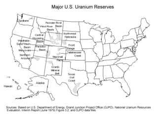
Uranium mining in the United States produced 173,875 pounds (78.9 tonnes) of U3O8 in 2019, 88% lower than the 2018 production of 1,447,945 pounds (656.8 tonnes) of U3O8 and the lowest US annual production since 1948. The 2019 production represents 0.3% of the anticipated uranium fuel requirements of the US's nuclear power reactors for the year.
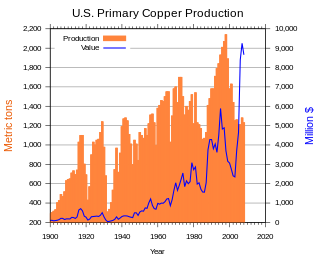
In the United States, copper mining has been a major industry since the rise of the northern Michigan copper district in the 1840s. In 2017, the US produced 1.27 million metric tonnes of copper, worth $8 billion, making it the world's fourth largest copper producer, after Chile, China, and Peru. Copper was produced from 23 mines in the US. Top copper producing states in 2014 were Arizona, Utah, New Mexico, Nevada, and Montana. Minor production also came from Idaho, and Missouri. As of 2014, the US had 45 million tonnes of known remaining reserves of copper, the fifth largest known copper reserves in the world, after Chile, Australia, Peru, and Mexico.

Uranium mining in Colorado, United States, goes back to 1872, when pitchblende ore was taken from gold mines near Central City, Colorado. The Colorado uranium industry has seen booms and busts, but continues to this day. Not counting byproduct uranium from phosphate, Colorado is considered to have the third largest uranium reserves of any US state, behind Wyoming and New Mexico.
Silver mining in Arizona was a powerful stimulus for exploration and prospecting in early Arizona. Cumulative silver production through 1981 totaled 490 million troy ounces. However, only about 10% of Arizona's silver production came from silver mining. More than 80% of the state's silver was a byproduct of copper mining; other silver came as a byproduct of lead, zinc, and gold mining.

Uranium mining in Utah, a state of the United States, has a history going back more than 100 years. Uranium mining started as a byproduct of vanadium mining about 1900, became a byproduct of radium mining about 1910, then back to a byproduct of vanadium when the radium price fell in the 1920s. Utah saw a uranium boom in the late 1940s and early 1950s, but uranium mining declined in the 1980s. Since 2001 there has been a revival of interest in uranium mining, as a result of higher uranium prices.

The mineral industry is one of the main sectors of the Armenian economy and in 2017 accounted for 30.1% of its exports.

Helvetia is a ghost town in Pima County, Arizona, United States that was settled in 1891 and abandoned in the early 1920s. Helvetia is an ancient name for Switzerland. Today, only the Ray Mine and cemetery are visitable, as the rest of the town has been fenced off due to active mining operations.

Harshaw is a ghost town in Santa Cruz County in the southeastern part of the U.S. state of Arizona. The town was settled in the 1870s, in what was then Arizona Territory. Founded as a mining community, Harshaw is named after the cattleman-turned-prospector David Tecumseh Harshaw, who first successfully located silver in the area. At the town's peak near the end of the 19th century, Harshaw's mines were among Arizona's highest producers of ore, with the largest mine, the Hermosa, yielding approximately $365,455 in bullion over a four-month period in 1880.

The Henderson molybdenum mine is a large underground molybdenum mine west of the town of Empire in Clear Creek County, Colorado, USA. The Henderson mine, which has produced molybdenum since 1976, is owned by Freeport-McMoRan.
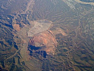
The San Manuel Copper Mine was a surface and underground porphyry copper mine located in San Manuel, Pinal County, Arizona. Frank Schultz was the original discoverer, in 1879, but the main body of the deposits were discovered by Henry W. Nichols in 1942. The exploration drilling went on from 1943 to 1948, with the first mine shaft built 1948. Louis Lesser developed a mining city to service Nichols’ newly discovered deposits, and the development was completed about 1954. The first major production began in 1955. The mine and smelter were permanently closed in 2003.
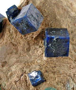
Boleite is a complex halide mineral with formula: KPb26Ag9Cu24(OH)48Cl62. It was first described in 1891 as an oxychloride mineral. It is an isometric mineral which forms in deep-blue cubes. There are numerous minerals related to boleite, such as pseudoboleite, cumengite, and diaboleite, and these all have the same complex crystal structure. They all contain bright-blue cubic forms and are formed in altered zones of lead and copper deposits, produced during the reaction of chloride bearing solutions with primary sulfide minerals.

Matlockite is a rare lead halide mineral, named after the town of Matlock in Derbyshire, England, where it was first discovered in a nearby mine. Matlockite gives its name to the matlockite group which consists of rare minerals of a similar structure.
Georgerobinsonite, named for George Willard Robinson, is a lead chromate mineral with formula Pb4(CrO4)2(OH)2FCl. It exhibits very small, transparent crystals with a bright orange-red color. It was obtained from the Mammoth–St. Anthony Mine in Arizona in the 1940s and identified in 2009.

The Mineral Park mine is a large open pit copper mine located in the Cerbat Mountains 14 miles northwest of Kingman, Arizona, in the southwestern United States. A 2013 report said that Mineral Park has an estimated reserves of 389 million tonnes of ore grading 0.14% copper and 31 million oz of silver.

The Tough Nut Mine is a silver mine established just prior to and just outside Tombstone in Cochise County, Arizona. After an early period of operation that began in the late 19th century, the mine was closed and then reopened in the 1970s.


