San Manuel, Arizona

Last updated

San Manuel, Arizona
CDP
85631-RedingtonRd.jpg
A view from Redington Rd SE of San Manuel with Galiuro Mountains in background.
Motto: 
"A Proud Past – An Epic Future"
Pinal County Arizona Incorporated and Unincorporated areas San Manuel highlighted.svg
Location in Pinal County and the state of Arizona
Usa edcp location map.svg
Red pog.svg
San Manuel, Arizona
Location in the United States
Coordinates: 32°36′18″N110°38′0″W / 32.60500°N 110.63333°W / 32.60500; -110.63333
CountryUnited States
State Arizona
County Pinal
Area
[1]
  Total20.75 sq mi (53.75 km2)
  Land20.75 sq mi (53.75 km2)
  Water0.00 sq mi (0.00 km2)
Elevation
3,451 ft (1,052 m)
Population
 (2020)
  Total3,114
  Density150.04/sq mi (57.93/km2)
Time zone UTC-7 (MST (no DST))
ZIP code
85631
Area code 520
FIPS code 04-63540
GNIS feature ID 34022

San Manuel is a census-designated place (CDP) in Pinal County, Arizona, United States. The population was 3,551 at the 2010 census.

Contents

San Manuel was built in 1953 by Del E. Webb Construction Company as a company town to serve the then-new San Manuel copper mine, mill and smelter complex. In 1955 the San Manuel Arizona Railroad was built to connect with the Copper Basin Railway at Hayden. [2] When copper prices fell in the late 1990s, BHP, the owner of the mine and smelter complex shuttered both operations in June 1999. The closing saw 2,500 people lose their jobs. The mine and smelter were permanently closed in 2003.

The community is on the edge of the Sonoran Desert with its saguaros and overlooks the San Pedro River valley and panoramic Galiuro Mountains. Today, San Manuel is a leisure destination popular for hunting, sightseeing, and is a hub for off-road adventure for dirt bikes, UTV's and ATV's. UTV. Several museums include a mining museum and a motorcycle museum. It is also a gateway city of The Arizona Trail. [3] [4] Nearby towns are Oracle and Mammoth. Both are within 10 mi (16 km) of San Manuel and make up a tri-community area.

Geography

San Manuel is located at 32°36′18″N110°38′0″W / 32.60500°N 110.63333°W / 32.60500; -110.63333 (32.605048, -110.633340), [5] in the San Pedro River Valley at an elevation of about 3,500 feet (1,100 m). San Manuel is approximately 45 miles (72 km) northeast of Tucson.

According to the United States Census Bureau, the CDP has a total area of 20.9 sq mi (54 km2) all land.

Highway access

The main road connecting San Manuel to the rest of the state is Veterans Memorial Boulevard, which runs in a northwest–southeast direction from San Pedro River Road to a grade–separated interchange with Arizona State Route 77. [6] From 1962 to 1988, Veterans Memorial Boulevard was part of Arizona State Route 76. [7] [8] SR 76 served as a direct connection from San Manuel to SR 77, the San Manuel copper mine and ultimately the rest of the state. [7] [6]

In the early 1970s, construction started on an extension of SR 76 to Interstate 10 in Benson, called the Benson–Mammoth Highway. However, the highway was ultimately abandoned at the beginning of construction, with only two sections being completed near San Manuel and in Benson, respectively, along with an abandoned and unfinished highway grade. The unfinished grade still remains at the southern end of Veterans Memorial Boulevard, blocked by a permanent traffic barrier. [6] [9] [10] SR 76 was later decommissioned as a state highway and handed to local jurisdictions for ownership and maintenance. Additionally, any land the state of Arizona had acquired for the Benson extension was sold off. [8]

Airport

San Manuel Airport – E77 known as San Manuel Ray Blair Airport is public and located 2 mi (3.2 km) NW of San Manuel, Arizona. It has one paved runway of 4,207 ft × 75 ft (1,282 m × 23 m) with lights and a paved taxiway. [11]

Local & area attractions

Events

Demographics

Historical population
CensusPop.Note
1960 4,524
1970 4,332−4.2%
1980 5,44325.6%
1990 4,009−26.3%
2000 4,3759.1%
2010 3,551−18.8%
2020 3,114−12.3%
U.S. Decennial Census [12] [13]

As of the census [14] of 2000, there were 4,375 people, 1,458 households, and 1,204 families residing in the CDP. The population density was 209.5 inhabitants per square mile (80.9/km2). There were 1,832 housing units at an average density of 87.7 per square mile (33.9/km2). The racial makeup of the CDP was 69.1% White, 0.4% Black or African American, 1.4% Native American, 0.3% Asian, 0.1% Pacific Islander, 24.8% from other races, and 4.0% from two or more races. 46.2% of the population were Hispanic or Latino of any race.

There were 1,458 households, out of which 43.1% had children under the age of 18 living with them, 66.3% were married couples living together, 10.6% had a female householder with no husband present, and 17.4% were non-families. 15.0% of all households were made up of individuals, and 6.7% had someone living alone who was 65 years of age or older. The average household size was 3.00 and the average family size was 3.31.

In the CDP, the population was spread out, with 32.6% under the age of 18, 8.8% from 18 to 24, 27.0% from 25 to 44, 21.1% from 45 to 64, and 10.5% who were 65 years of age or older. The median age was 32 years. For every 100 females, there were 102.5 males. For every 100 females age 18 and over, there were 98.1 males.

The median income for a household in the CDP was $40,019, and the median income for a family was $42,563. Males had a median income of $36,463 versus $21,304 for females. The per capita income for the CDP was $16,534. About 10.3% of families and 12.8% of the population were below the poverty line, including 18.4% of those under age 18 and 5.6% of those age 65 or over.

Off-road adventure with UTV's at San Manuel, Arizona. Off-road Adventure with UTV's at San Manuel, Arizona.jpg
Off-road adventure with UTV's at San Manuel, Arizona.
JWJ Cycles - Motorcycle museum in San Manuel, Arizona JWJ Cycles.jpg
JWJ Cycles - Motorcycle museum in San Manuel, Arizona

Related Research Articles

<span class="mw-page-title-main">Claypool, Arizona</span> CDP in Gila County, Arizona

Claypool is a census-designated place (CDP) in Gila County, Arizona, United States. The population was 1,538 at the 2010 census, down from 1,794 at the 2000 census. It was named after W. D. Claypool, a member of both the State House of Representatives and State Senate in the 1910s and 1920s.

<span class="mw-page-title-main">Hayden, Arizona</span> Town in Gila and Pinal Counties, Arizona

Hayden is a town in Gila and Pinal counties in Arizona, United States. According to the 2010 census, the population of the town was 662.

<span class="mw-page-title-main">Miami, Arizona</span> Town in Gila County, Arizona

Miami is a town in Gila County, Arizona, United States. Miami is a classic Western copper boom-town. Miami's old downtown has been partly renovated, and the Bullion Plaza Museum features the cultural, mining and ranching history of the Miami area.

<span class="mw-page-title-main">Strawberry, Arizona</span> CDP in Gila County, Arizona

Strawberry is an unincorporated community and census-designated place (CDP) in Gila County, Arizona, United States. The population was 961 at the 2010 census.

<span class="mw-page-title-main">Morenci, Arizona</span> CDP in Greenlee County, Arizona

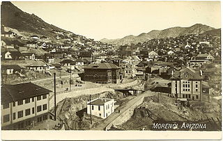
Morenci is a census-designated place (CDP) and company town in Greenlee County, Arizona, United States, and was founded by the Detroit Copper Mining Company of Arizona. The population was 2,000 at the 2000 census and 1,489 at the 2010 census. The biggest employer in Morenci and the owner of the town is Freeport-McMoRan, the owner of the Morenci Mine, the largest copper mining operation in North America, and one of the largest copper mines in the world. The town was a site of the Arizona Copper Mine Strike of 1983. The large open-pit mine is north of the town.

<span class="mw-page-title-main">Ajo, Arizona</span> Community in Pima County, Arizona

Ajo is an unincorporated community in Pima County, Arizona, United States. It is the closest community to Organ Pipe Cactus National Monument. The population was 3,039 at the 2020 census. Ajo is located on State Route 85 just 43 miles (69 km) from the Mexican border.

<span class="mw-page-title-main">Drexel-Alvernon, Arizona</span> CDP in Pima County, Arizona

Drexel-Alvernon was a census-designated place (CDP) in Pima County, Arizona, United States. The population was 4,192 at the 2000 census.

<span class="mw-page-title-main">Mammoth, Arizona</span> Town in Pinal County, Arizona

Mammoth is a town in Pinal County, Arizona, United States. The population was 1,426 at the 2010 census; according to 2018 Census Bureau estimates, the population of the town is 1,650.

<span class="mw-page-title-main">Oracle, Arizona</span> CDP in Pinal County, Arizona

Oracle is a census-designated place (CDP) in Pinal County, Arizona, United States. The population was 3,686 at the 2010 Census, falling to 3,051 at the 2020 Census.

<span class="mw-page-title-main">Dewey–Humboldt, Arizona</span> Town in Yavapai County, Arizona

Dewey–Humboldt is a town in Yavapai County, Arizona, United States. The population of the town was 3,894 according to the 2010 census. The Dewey–Humboldt area was a census-designated place (CDP) at the 2000 census, at which time its population was 6,295.

<span class="mw-page-title-main">Byron, California</span> Census designated place in California, United States

Byron is a census designated place (CDP) in Contra Costa County, California, United States.

<span class="mw-page-title-main">Prunedale, California</span> Place in California, United States

Prunedale is a unincorporated community in Monterey County, California, United States. It is located 8 miles (13 km) north of Salinas at an elevation of 92 feet (28 m). The population was 18,885 as of the 2020 census, up from 17,560 in 2010. For statistical purposes, the United States Census Bureau has defined Prunedale as a census-designated place (CDP). Plum trees were grown in Prunedale in the early days of its founding, but the trees died soon after due to poor irrigation and fertilizer.

<span class="mw-page-title-main">Joshua Tree, California</span> Census-designated place in California, United States

Joshua Tree is a census-designated place (CDP) in San Bernardino County, California, United States. The population was 7,414 at the 2010 census. At approximately 2,700 feet above sea level, Joshua Tree and its surrounding communities are located in the High Desert of California. The center of the business district in Joshua Tree is on California State Route 62.

<span class="mw-page-title-main">West Perrine, Florida</span> Census-designated place in Florida

West Perrine is a census-designated place (CDP) in Miami-Dade County, Florida, United States. It is part of the Miami metropolitan area of South Florida. The population was 10,602 at the 2020 census, up from 9,460 in 2010.

<span class="mw-page-title-main">Kihei, Hawaii</span> Census-designated place in Hawaii, United States

Kihei is a census-designated place (CDP) in Maui County, Hawaii, United States. The population was 21,423 at the 2020 census.

<span class="mw-page-title-main">Lime Ridge, Pennsylvania</span> Census-designated place in Pennsylvania, United States

Lime Ridge is a census-designated place (CDP) in Columbia County, Pennsylvania, United States. It is part of Northeastern Pennsylvania. The population was 823 at the 2020 census. It is part of the Bloomsburg-Berwick micropolitan area.

<span class="mw-page-title-main">Montezuma Creek, Utah</span> Census-designated place in Utah, United States

Montezuma Creek is a census-designated place (CDP) in San Juan County, Utah, United States. The population was 335 at the 2010 census, a decrease from the 2000 figure of 507.

<span class="mw-page-title-main">Seven Corners, Virginia</span> Census-designated place in Virginia, United States

Seven Corners is a commercial center and census-designated place (CDP) in Fairfax County, Virginia, United States. The population was 9,255 at the 2010 census. Seven Corners has a "Falls Church" mailing address but is not within Falls Church's city limits. The area got its name from the intersection of State Route 7, U.S. Route 50, State Route 613, State Route 338 and Wilson Boulevard. The junction of these four roads once created seven corners.

<span class="mw-page-title-main">Arizona State Route 80</span> State highway in Arizona, United States

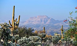
State Route 80 (SR 80) is a 120.20-mile (193.44-kilometre) long, roughly arc-shaped highway lying in southeastern Arizona. Starting in downtown Benson, the highway serves as the main route through the towns of St. David, Tombstone, Bisbee and Douglas before terminating at the New Mexico state line, becoming New Mexico State Road 80 (NM 80). SR 80 also acts as the national southern terminus of US 191 near Douglas and provides the only connection between the U.S. Highway and its business route in Douglas.

<span class="mw-page-title-main">Arizona State Route 76</span> Former state highway in Arizona, United States

Arizona State Route 76 (SR 76) was a short state highway in eastern central Arizona, United States that connected State Route 77 to the San Manuel Copper Mine and San Manuel with a detached southern segment connecting Pomerene to Benson. The highway was planned to be completed through Pima County between Pomerene and San Manuel. However, it was never completed, and the next planned segment was abandoned during construction. Two other sections were constructed north of Pomerene and south of Redington but were never formally designated SR 76 or connected to the rest of the route.

References

  1. "2020 U.S. Gazetteer Files". United States Census Bureau. Retrieved October 29, 2021.
  2. "A history of the San Manuel Arizona Railroad 'SMARRCO'" . Retrieved October 30, 2021.
  3. "San Manuel, Arizona – Fun Guide" . Retrieved October 10, 2023.
  4. "The Arizona Trail Gateway Communities" . Retrieved December 28, 2017.
  5. "US Gazetteer files: 2010, 2000, and 1990". United States Census Bureau. February 12, 2011. Retrieved April 23, 2011.
  6. 1 2 3 Google (June 18, 2019). "Former SR 76" (Map). Google Maps . Google. Retrieved June 18, 2019.
  7. 1 2 Staff. "ADOT Right-of-Way Resolution 1962-P-158". Arizona Department of Transportation. Retrieved June 18, 2019.
  8. 1 2 Staff. "ADOT Right-of-Way Resolution 1988-06-A-055". Arizona Department of Transportation. Retrieved June 18, 2019.
  9. Google (June 18, 2019). "Former SR 76 (Pomerene Road)" (Map). Google Maps . Google. Retrieved June 18, 2019.
  10. Arizona Department of Transportation (November 25, 2014). "SR 76 - Benson Mammoth Highway (Survey Only) - Right Of Way Index Map" (Right of Way Map) (PDF). Phoenix, Arizona. Retrieved June 19, 2019.
  11. "AirNav, LLC" . Retrieved December 28, 2017.
  12. "Number of Inhabitants Arizona" (PDF). Census.gov. Retrieved January 5, 2018.
  13. "1990 Census of Population General Population Characteristics Arizona" (PDF). Census.gov. Retrieved January 5, 2018.
  14. "U.S. Census website". United States Census Bureau . Retrieved January 31, 2008.