Cascade Valley, Washington

Last updated

Cascade Valley, Washington
Grant County Washington Incorporated and Unincorporated areas Cascade Valley Highlighted.svg
Location of Cascade Valley, Washington
Coordinates: 47°8′42″N119°19′24″W / 47.14500°N 119.32333°W / 47.14500; -119.32333
CountryUnited States
State Washington
County Grant
Area
  Total4.60 sq mi (11.92 km2)
  Land2.97 sq mi (7.68 km2)
  Water1.64 sq mi (4.24 km2)
Elevation
1,060 ft (323 m)
Population
 (2020) [1]
  Total4,332
  Density940/sq mi (360/km2)
Time zone UTC-8 (Pacific (PST))
  Summer (DST) UTC-7 (PDT)
ZIP code
98837 [2]
Area code 509
FIPS code 53-10455 [3]
GNIS feature ID1867603 [4]

Cascade Valley is a census-designated place (CDP) in Grant County, Washington, United States. The population was 2,246 at the 2010 census, [5] up from 1,811 at the 2000 census.

Contents

Geography

Cascade Valley is located in eastern Grant County at 47°8′42″N119°19′24″W / 47.14500°N 119.32333°W / 47.14500; -119.32333 (47.144958, -119.323447). [6] It is bordered to the east and south by the city of Moses Lake, and to the west by the water body of Moses Lake.

According to the United States Census Bureau, the CDP has a total area of 4.6 square miles (11.9 km2), of which 3.0 square miles (7.7 km2) are land and 1.6 square miles (4.2 km2), or 35.62%, are water. [5]

Demographics

As of the census [3] of 2000, there were 1,811 people, 665 households, and 474 families residing in the CDP. The population density was 654.7 people per square mile (252.4/km2). There were 759 housing units at an average density of 274.4/sq mi (105.8/km2). The racial makeup of the CDP was 79.73% White, 2.87% African American, 1.44% Native American, 0.33% Asian, 0.06% Pacific Islander, 11.32% from other races, and 4.25% from two or more races. Hispanic or Latino of any race were 17.12% of the population.

There were 665 households, out of which 36.1% had children under the age of 18 living with them, 57.4% were married couples living together, 10.1% had a female householder with no husband present, and 28.6% were non-families. 22.6% of all households were made up of individuals, and 6.8% had someone living alone who was 65 years of age or older. The average household size was 2.72 and the average family size was 3.16.

In the CDP, the age distribution of the population shows 29.3% under the age of 18, 9.3% from 18 to 24, 30.3% from 25 to 44, 21.3% from 45 to 64, and 9.9% who were 65 years of age or older. The median age was 33 years. For every 100 females, there were 105.8 males. For every 100 females age 18 and over, there were 106.3 males.

The median income for a household in the CDP was $37,344, and the median income for a family was $41,250. Males had a median income of $35,179 versus $23,693 for females. The per capita income for the CDP was $16,170. About 13.5% of families and 15.0% of the population were below the poverty line, including 18.1% of those under age 18 and 2.1% of those age 65 or over.

Related Research Articles

<span class="mw-page-title-main">Valley Acres, California</span> Census-designated place in California, United States

Valley Acres is a census-designated place (CDP) in Kern County, California, United States. Valley Acres is located 5.2 miles (8.4 km) north-northeast of Taft, at an elevation of 420 feet (128.02 m). The population was 527 at the 2010 census, up from 512 at the 2000 census.

<span class="mw-page-title-main">Strathmore, California</span> Census-designated place in California, United States

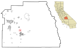
Strathmore is a census-designated place (CDP) in Tulare County, California, United States. The population was 2,819 at the 2010 census, up from 2,584 at the 2000 census.

<span class="mw-page-title-main">Anahola, Hawaii</span> Census-designated place in Hawaii, United States

Anahola is a census-designated place (CDP) in Kauaʻi County, Hawaiʻi, United States. The population was 2,311 at the 2020 census, up from 1,932 at the 2000 census.

<span class="mw-page-title-main">Highfield-Cascade, Maryland</span> CDP in Maryland, United States

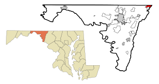
Highfield-Cascade is a census-designated place (CDP) in Washington County, Maryland, United States. The CDP is, however, more commonly referred to as just Cascade, MD. The official CDP name encompasses two closely-spaced unincorporated communities, Highfield and Cascade. The population of the CDP was 1,141 at the 2000 census.

<span class="mw-page-title-main">Fort Shaw, Montana</span> CDP in Montana, United States

Fort Shaw is a census-designated place (CDP) in Cascade County, Montana, United States. The population was 280 at the 2010 census. Named for a former United States military outpost, it is part of the Great Falls, Montana Metropolitan Statistical Area.

<span class="mw-page-title-main">Simms, Montana</span> CDP in Montana, United States

Simms is a census-designated place (CDP) in Cascade County, Montana, United States. The population was 354 at the 2010 census. It is part of the Great Falls, Montana Metropolitan Statistical Area.

<span class="mw-page-title-main">Sun Prairie, Montana</span> CDP in Montana, United States

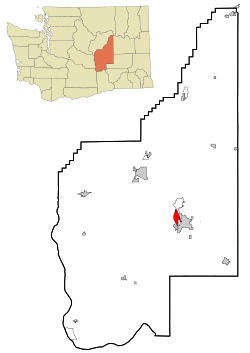
Sun Prairie is a census-designated place (CDP) in Cascade County, Montana, United States. The population was 1,630 at the 2010 census. It is part of the Great Falls Metropolitan Statistical Area and may have evolved as a remote suburb of Great Falls.

<span class="mw-page-title-main">Ulm, Montana</span> CDP in Montana, United States

Ulm is a census-designated place (CDP) in Cascade County, Montana, United States. It was originally a large ranch owned by Indiana-born cattleman William Ulm. The population was 738 at the 2010 census. It is part of the Great Falls, Montana Metropolitan Statistical Area. The Zip Code is 59485.

<span class="mw-page-title-main">Old Agency, Montana</span> CDP in Montana, United States

Old Agency is a census-designated place (CDP) in Sanders County, Montana, United States. The population was 95 at the 2000 census.

<span class="mw-page-title-main">Monarch Mill, South Carolina</span> CDP in South Carolina, United States

Monarch Mill is a census-designated place (CDP) in Union County, South Carolina, United States. The population was 1,811 at the 2010 census.

<span class="mw-page-title-main">West Alto Bonito, Texas</span> CDP in Texas, United States

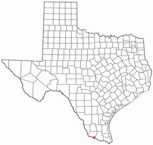
West Alto Bonito is a census-designated place (CDP) in Starr County, Texas, United States. The population was 696 in 2010 census. Prior to the 2010 census, West Alto Bonito CDP was known as Alto Bonito CDP.

<span class="mw-page-title-main">Clarkston Heights-Vineland, Washington</span> CDP in Washington, United States

Clarkston Heights-Vineland is a census-designated place (CDP) in Asotin County, Washington, United States. It is part of the Lewiston, ID–WA Metropolitan Statistical Area. The population was 7,275 at the 2020 census.

<span class="mw-page-title-main">South Wenatchee, Washington</span> Census-designated place in Washington, United States

South Wenatchee is an unincorporated community and census-designated place (CDP) in Chelan County, Washington, United States. It is part of the Wenatchee–East Wenatchee Metropolitan Statistical Area. The population was 1,522 at the 2020 census.

<span class="mw-page-title-main">Banks Lake South, Washington</span> Census-designated place in Washington, United States

Banks Lake South is a census-designated place (CDP) in Grant County, Washington, United States. The population was 234 at the 2020 census.

<span class="mw-page-title-main">Lakeview, Washington</span> Census-designated place in Washington, United States

Lakeview is a census-designated place (CDP) in Grant County, Washington, United States. The population was 915 at the 2010 census, up from 797 at the 2000 census. The community is referred to as Lakeview Park on topographic maps and by locals.

<span class="mw-page-title-main">Moses Lake North, Washington</span> Census-designated place in Washington, United States

Moses Lake North is a census-designated place (CDP) in Grant County, Washington, United States. It is also included in the Moses Lake micropolitan area. The population was 4,050 at the 2020 census.

<span class="mw-page-title-main">Baring, Washington</span> Census-designated place in Washington, United States

Baring is an unincorporated community and census-designated place (CDP) in King County, Washington, United States. The population was 255 at the 2020 census, up from 220 at the 2010 census. It is located on U.S. Highway 2 about 23 miles (37 km) west of Stevens Pass, along a very flat and straight three-mile section of highway that has been dubbed the "Baring Straight", since US-2 is otherwise hilly and curvy through the mountains. The settlement was first known as "Salmon", but by 1909 it was known as Baring.

<span class="mw-page-title-main">Easton, Washington</span> Census-designated place in Washington, United States

Easton is an unincorporated community and census-designated place (CDP) in Kittitas County, Washington, United States. The population was 478 at the 2010 census. Easton is the annual site of the start/finish line for the Cascade Crest 100-mile ultra-running race.

<span class="mw-page-title-main">Snoqualmie Pass, Washington</span> Census-designated place in Washington, United States

Snoqualmie Pass is a census-designated place (CDP) in Kittitas County, Washington, United States. It includes the unincorporated community of Hyak. The population was 311 at the 2010 census.

<span class="mw-page-title-main">Mount Gay-Shamrock, West Virginia</span> Census-designated place in West Virginia, United States

Mount Gay-Shamrock is a census-designated place (CDP) in Logan County, West Virginia, United States.

References

  1. "Census Bureau profile: Cascade Valley, Washington". United States Census Bureau. May 2023. Retrieved May 9, 2024.
  2. "Cascade Valley WA ZIP Code". zipdatamaps.com. 2023. Retrieved January 26, 2023.
  3. 1 2 "U.S. Census website". United States Census Bureau . Retrieved January 31, 2008.
  4. "Cascade Valley". Geographic Names Information System . United States Geological Survey, United States Department of the Interior.
  5. 1 2 "Geographic Identifiers: 2010 Demographic Profile Data (G001): Cascade Valley CDP, Washington". American Factfinder. U.S. Census Bureau. Retrieved March 30, 2017.[ dead link ]
  6. "US Gazetteer files: 2010, 2000, and 1990". United States Census Bureau. February 12, 2011. Retrieved April 23, 2011.