Electric City, Washington

Last updated

Electric City
Electric City, Washington
Grant County Washington Incorporated and Unincorporated areas Electric City Highlighted.svg
Location of Electric City, Washington
Coordinates: 47°55′51″N119°2′10″W / 47.93083°N 119.03611°W / 47.93083; -119.03611
CountryUnited States
State Washington
County Grant
Area
[1]
  Total2.64 sq mi (6.84 km2)
  Land1.99 sq mi (5.15 km2)
  Water0.65 sq mi (1.69 km2)
Elevation
1,650 ft (503 m)
Population
 (2020) [2]
  Total956
  Density504.02/sq mi (194.60/km2)
Time zone UTC-8 (Pacific (PST))
  Summer (DST) UTC-7 (PDT)
ZIP code
99123
Area code 509
FIPS code 53-21030
GNIS feature ID1504703 [3]
Website electriccity.us

Electric City is a city in Grant County, Washington. The population was 956 at the time of the 2020 census. [2] The community was named for its proximity to the power source at Grand Coulee Dam.

Contents

History

Electric City was established in 1934 as one of several settlements around the future site of the Grand Coulee Dam that aimed to house construction workers. [4] [5] President Franklin D. Roosevelt stopped at Electric City during his tour of the dam site later that year; by August, 500 lots had been platted for the town. [6] Some of the earliest buildings in Electric City had been relocated from nearby Osborne, which was inundated by Franklin D. Roosevelt Lake following the dam's completion. [7] A post office was created for the settlement in June 1935 and was followed by a school a year later. [8] [9]

Electric City was incorporated as a fourth-class city on August 4, 1950, following a vote on July 8. [10] The 1950 U.S. census counted a population of 1,472 people in the Electric City area a few months before the election. [11] A group of residents contested the validity of the incorporation and appealed to the Grant County's superior court, [12] which did not overturn the incorporation. [10]

Geography

Overview of Franklin Delano Roosevelt Lake from the south looking downstream toward Grand Coulee Dam. Grand Coulee and Electric City to the west. Franklin Delano Roosevelt Lake, WA.JPG
Overview of Franklin Delano Roosevelt Lake from the south looking downstream toward Grand Coulee Dam. Grand Coulee and Electric City to the west.

Electric City is located near the northern end of the Grand Coulee (now filled by Banks Lake) in northern Grant County, Washington. It is southwest of the Grand Coulee Dam and the city of Grand Coulee, and connected to both by State Route 155. [13]

According to the United States Census Bureau, the city has a total area of 2.34 square miles (6.06 km2), of which, 1.70 square miles (4.40 km2) is land and 0.64 square miles (1.66 km2) is water. [14]

Climate

Climate data for Electric City, Washington
MonthJanFebMarAprMayJunJulAugSepOctNovDecYear
Record high °F (°C)61
(16)
61
(16)
73
(23)
91
(33)
100
(38)
102
(39)
108
(42)
110
(43)
103
(39)
84
(29)
69
(21)
58
(14)
110
(43)
Average high °F (°C)33
(1)
40
(4)
52
(11)
61
(16)
70
(21)
78
(26)
87
(31)
87
(31)
77
(25)
61
(16)
43
(6)
32
(0)
60
(16)
Average low °F (°C)23
(−5)
25
(−4)
31
(−1)
37
(3)
45
(7)
51
(11)
58
(14)
57
(14)
49
(9)
39
(4)
30
(−1)
22
(−6)
39
(4)
Record low °F (°C)−17
(−27)
−15
(−26)
21
(−6)
21
(−6)
36
(2)
40
(4)
38
(3)
30
(−1)
7
(−14)
−10
(−23)
−16
(−27)
−17
(−27)
Average precipitation inches (mm)1.06
(27)
1.00
(25)
0.91
(23)
0.87
(22)
1.15
(29)
1.05
(27)
0.64
(16)
0.28
(7.1)
0.44
(11)
0.68
(17)
1.30
(33)
1.45
(37)
10.83
(274.1)
[ citation needed ]

Demographics

Historical population
CensusPop.Note
1960 404
1970 65161.1%
1980 92742.4%
1990 910−1.8%
2000 9221.3%
2010 9685.0%
2020 956−1.2%
U.S. Decennial Census [15]
2020 Census [2]

2010 census

As of the census [16] of 2010, there were 968 people, 447 households, and 275 families residing in the city. The population density was 569.4 inhabitants per square mile (219.8/km2). There were 524 housing units at an average density of 308.2 per square mile (119.0/km2). The racial makeup of the city was 86.0% White, 0.5% African American, 5.2% Native American, 0.4% Asian, 0.9% from other races, and 7.0% from two or more races. Hispanic or Latino of any race were 4.0% of the population.

There were 447 households, of which 21.3% had children under the age of 18 living with them, 50.1% were married couples living together, 8.9% had a female householder with no husband present, 2.5% had a male householder with no wife present, and 38.5% were non-families. 33.3% of all households were made up of individuals, and 13.6% had someone living alone who was 65 years of age or older. The average household size was 2.17 and the average family size was 2.71.

The median age in the city was 50.5 years. 18.3% of residents were under the age of 18; 5% were between the ages of 18 and 24; 18.1% were from 25 to 44; 36.4% were from 45 to 64; and 22.2% were 65 years of age or older. The gender makeup of the city was 49.7% male and 50.3% female.

2000 census

As of the census of 2000, there were 922 people, 382 households, and 291 families residing in the city. The population density was 1,706.3 people per square mile (659.2/km2). There were 420 housing units at an average density of 777.3 per square mile (300.3/km2). The racial makeup of the city was 89.59% White, 0.22% African American, 7.05% Native American, 0.65% Asian, 0.11% Pacific Islander, 0.11% from other races, and 2.28% from two or more races. Hispanic or Latino of any race were 1.84% of the population.

There were 382 households, out of which 27.0% had children under the age of 18 living with them, 63.6% were married couples living together, 8.1% had a female householder with no husband present, and 23.8% were non-families. 20.2% of all households were made up of individuals, and 7.3% had someone living alone who was 65 years of age or older. The average household size was 2.41 and the average family size was 2.74.

In the city, the age distribution of the population shows 23.1% under the age of 18, 6.1% from 18 to 24, 18.4% from 25 to 44, 33.9% from 45 to 64, and 18.4% who were 65 years of age or older. The median age was 46 years. For every 100 females, there were 92.9 males. For every 100 females age 18 and over, there were 95.3 males.

The median income for a household in the city was $42,321, and the median income for a family was $47,969. Males had a median income of $46,667 versus $20,288 for females. The per capita income for the city was $19,388. About 11.6% of families and 12.4% of the population were below the poverty line, including 18.0% of those under age 18 and 9.5% of those age 65 or over.

Notable people

Related Research Articles

<span class="mw-page-title-main">Grant County, Washington</span> County in Washington, United States

Grant County is a county located in the U.S. state of Washington. As of the 2020 census, the population was 99,123. The county seat is Ephrata, and the largest city is Moses Lake. The county was formed out of Douglas County in February 1909 and is named for U.S. President Ulysses S. Grant.

<span class="mw-page-title-main">Rupert, Idaho</span> City in Idaho, United States

Rupert is the county seat and largest city of Minidoka County, Idaho,. It is part of the Burley Micropolitan Statistical Area. The population was 6,082 at the 2020 census, up from 5,554 in 2010.

<span class="mw-page-title-main">Cascade, Idaho</span> City in Idaho, United States

Cascade is a rural city in and the county seat of Valley County, Idaho, United States. The population was 939 at the 2010 census, down from 997 in 2000.

<span class="mw-page-title-main">Delhi, Iowa</span> City in Iowa, United States

DelhiDEL-hy is a city in Delaware County, Iowa, United States. The population was 420 at the time of the 2020 census.

<span class="mw-page-title-main">Lake Shore, Minnesota</span> City in Minnesota, United States

Lake Shore is a city in Cass County, Minnesota, United States. The population was 1,056 at the 2020 census. It is part of the Brainerd Micropolitan Statistical Area.

Birch Cooley Township is a township in Renville County, Minnesota, United States. The population was 257 at the 2000 census.

<span class="mw-page-title-main">Morton, Minnesota</span> City in Minnesota, United States

Morton is a city in Renville County, Minnesota, United States. This city is ninety-five miles southwest of Minneapolis. It is the administrative headquarters of the Lower Sioux Indian Reservation. The population was 411 at the 2010 census.

<span class="mw-page-title-main">Federal Dam, Minnesota</span> City in Minnesota, United States

Federal Dam is a city in Cass County, Minnesota, United States, near Leech Lake. The population was 110 at the 2010 census. It is part of the Brainerd Micropolitan Statistical Area.

<span class="mw-page-title-main">Washtucna, Washington</span> Town in Washington, United States

Washtucna is a town in Adams County, Washington, United States. The population was 211 at the 2020 census, a 1% increase over the previous census. The town was named for a lake 12 miles from the town in Franklin County which was in turn named after a Palouse Native American chief.

<span class="mw-page-title-main">Entiat, Washington</span> City in Washington, United States

Entiat is a city in Chelan County, Washington, United States. It is part of the Wenatchee−East Wenatchee Metropolitan Statistical Area. The population was 1,326 at the 2020 census.

<span class="mw-page-title-main">Inchelium, Washington</span> CDP in Washington, United States

Inchelium is a census-designated place (CDP) in Ferry County, Washington, United States on the Colville Indian Reservation. The population was 431 at the 2020 Census.

<span class="mw-page-title-main">Kahlotus, Washington</span> City in Washington, United States

Kahlotus is a city in Franklin County, Washington, United States. The population was 193 at the 2010 census. The Washington State Office of Financial Management's 2015 estimate placed the population at 190.

<span class="mw-page-title-main">Banks Lake South, Washington</span> Census-designated place in Washington, United States

Banks Lake South is a census-designated place (CDP) in Grant County, Washington, United States. The population was 174 at the 2010 census.

<span class="mw-page-title-main">Coulee City, Washington</span> Town in Washington, United States

Coulee City is a town in Grant County, Washington. The population was 549 at the 2020 census.

<span class="mw-page-title-main">Ephrata, Washington</span> City in Washington, United States

Ephrata is a city in and the county seat of Grant County, Washington, United States. Its population was 8,477 at the 2020 census.

<span class="mw-page-title-main">Grand Coulee, Washington</span> City in Washington, United States

Grand Coulee is a city in Grant County, Washington, United States. The population was 972 at the 2020 census.

<span class="mw-page-title-main">Hartline, Washington</span> Town in Washington, United States

Hartline is a town in Grant County, Washington, United States. The population was 180 at the 2020 census. The high school for the Almira-Coulee/Hartline school district was located here, but moved to Coulee City, Washington in 2008. The name "Hartline" is an Americanized spelling of the German last name "Hartlein" and is an uncommon last name.

<span class="mw-page-title-main">Soap Lake, Washington</span> City in Washington, United States

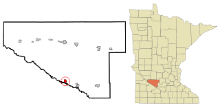
Soap Lake is a city in Grant County, Washington, on the shores of Soap Lake. The population was 1,691 at the 2020 census.

<span class="mw-page-title-main">Coulee Dam, Washington</span> Town in Washington, United States

Coulee Dam is a town in Douglas, Grant, and Okanogan counties in the State of Washington. The Douglas County portion of Coulee Dam is part of the Wenatchee–East Wenatchee Metropolitan Statistical Area. The population was 1,211 as of the 2020 census.

<span class="mw-page-title-main">Pacific, Washington</span> City in Washington, United States

Pacific is a city in King and Pierce counties in the State of Washington. Located primarily in King County, the population was 7,235 at the 2020 census.

References

  1. "2019 U.S. Gazetteer Files". United States Census Bureau. Retrieved August 7, 2020.
  2. 1 2 3 "2020 Census Redistricting Data (Public Law 94-171) Summary File". American FactFinder. United States Census Bureau . Retrieved March 18, 2022.
  3. "Electric City". Geographic Names Information System . United States Geological Survey, United States Department of the Interior.
  4. "New Buildings For Dam Site". The Spokesman-Review . March 5, 1934. p. 2. Retrieved March 5, 2023 via Newspapers.com.
  5. "Roosevelt Will View Progress At Dam Site". Spokane Daily Chronicle . August 3, 1934. p. 6. Retrieved March 5, 2023 via Newspapers.com.
  6. "Phones Popular in Coulee Area". The Spokesman-Review. August 14, 1934. p. 3. Retrieved March 5, 2023 via Newspapers.com.
  7. "Electric City". Coulee Corridor Consortium. Retrieved March 5, 2023.
  8. "$6,000,000 Spent on MWAK Work". The Spokesman-Review. June 19, 1935. p. 10. Retrieved March 5, 2023 via Newspapers.com.
  9. "Electric City School on Way". The Spokesman-Review. October 17, 1936. p. 11. Retrieved March 5, 2023 via Newspapers.com.
  10. 1 2 Troy, Smith (July 26, 1951). "Date of Incorporation of Electric City for Participation in Distribution of Liquor Control Board". Letter to Cliff Yelle. Washington State Office of the Attorney General . Retrieved March 5, 2023.
  11. "Census Figures Given For Area". The Spokesman-Review. June 16, 1950. p. 12. Retrieved March 5, 2023 via Newspapers.com.
  12. "Electric City Action Opposed". Spokane Daily Chronicle. August 9, 1950. p. 3. Retrieved March 5, 2023 via Newspapers.com.
  13. Washington State Department of Transportation (2014). Washington State Highways, 2014–2015 (PDF) (Map). 1:842,000. Olympia: Washington State Department of Transportation. Retrieved March 5, 2023.
  14. "US Gazetteer files 2010". United States Census Bureau. Archived from the original on January 25, 2012. Retrieved December 19, 2012.
  15. United States Census Bureau. "Census of Population and Housing" . Retrieved October 2, 2013.
  16. "U.S. Census website". United States Census Bureau . Retrieved December 19, 2012.