Centerville, Georgia

Last updated

Centerville, Georgia
Centerville Water Tower.jpg
Flag of Centerville, Georgia.png
Seal of Centerville, Georgia.png
Logo of Centerville, Georgia.png
Houston County Georgia Incorporated and Unincorporated areas Centerville Highlighted.svg
Location in Houston County and the state of Georgia
Coordinates: 32°36′31″N83°38′17″W / 32.60861°N 83.63806°W / 32.60861; -83.63806
Country United States
State Georgia
County Houston
FoundedMarch 25, 1958
Government
   Mayor John Harley
   City Council Bob Bird
Justin Wright
J. Michael Evans
Edward D. Armijo
Area
[1]
  Total3.97 sq mi (10.28 km2)
  Land3.94 sq mi (10.22 km2)
  Water0.02 sq mi (0.06 km2)  0.58%
Elevation
449 ft (137 m)
Population
 (2020)
  Total8,228
  Density2,085.68/sq mi (805.37/km2)
Time zone UTC-5 (Eastern)
  Summer (DST) UTC-4 (Eastern)
ZIP code
31028
Area code 478
FIPS code 13-14920 [2]
GNIS feature ID0355090 [3]
Website www.centervillega.org

Centerville is a city in Houston County, Georgia, United States. The city is a part of the larger Macon-Warner Robins Combined Statistical Area. It was incorporated March 25, 1958. As of the 2010 census, the city had a population of 7,148, [4] up from 4,278 in 2000. The city's central location, proximity to major highways and interstates, and excellent quality of life makes it one of the top bedroom communities in Georgia. In 2016, Centerville was ranked 7th Happiest City in Georgia by zippia.com, a website devoted to career-related rankings.

Contents

Etymology

Contrary to popular belief, Centerville owes its name not to its geographical position within the state of Georgia, but its position between County seat of Bibb County (Macon) and the county Seat of Houston County (Perry). [5]

Geography

Centerville is located in northern Houston County at 32°37′56″N83°40′41″W / 32.63222°N 83.67806°W / 32.63222; -83.67806 (32.632111, -83.677950). [6] It is bordered to the east and south by the city of Warner Robins and to the west by the city of Byron in Peach County. U.S. Route 41 passes through the west side of Centerville, leading north 17 miles (27 km) to Macon and south 12 miles (19 km) to Perry, the Houston County seat. State Route 247 Connector (Watson Boulevard) forms the southern edge of Centerville, leading east into Warner Robins and west 3 miles (5 km) to Interstate 75 at Exit 146.

According to the United States Census Bureau, Centerville has a total area of 4.0 square miles (10.3 km2), of which 0.023 square miles (0.06 km2), or 0.58%, are water. [4]

Demographics

Historical population
CensusPop.Note
1960 290
1970 1,725494.8%
1980 2,62252.0%
1990 3,25124.0%
2000 4,27831.6%
2010 7,14867.1%
2020 8,22815.1%
U.S. Decennial Census [7]
Centerville racial composition as of 2020 [8]
RaceNum.Perc.
White (non-Hispanic)4,49854.67%
Black or African American (non-Hispanic)2,29127.84%
Native American 350.43%
Asian 4245.15%
Pacific Islander 10.01%
Other/Mixed 4505.47%
Hispanic or Latino 5296.43%

As of the 2020 United States census, there were 8,228 people, 2,891 households, and 2,122 families residing in the city.

Government

The City of Centerville has a weak Mayor-Council form of government, meaning the Mayor's vote counts equal to that of each council person's vote. The services that the city government provides include curbside trash pick-up, sewer, and water. Centerville also has a Recycling Center within city limits accepting paper, metals, glass, and other miscellaneous items. The Recycling Center is staffed by volunteers. The City has a senior tax exemption law that allows citizens 70 and over to apply for a total tax exemption for their personal home and up to one acre of land, provided their home is located on the land.

Transportation

Major Roadways

The major roadways in and around Centerville include I-75, GA Highway 247 Connector (Watson Blvd), and GA Highway 41.

Pedestrians

In 2012, Centerville adopted the sidewalk improvement plan. This plan continues to improve pedestrian walkways in Centerville. In January 2017, the Houston County Commission approved contracts to design two road widening projects. The largest of these two projects was in Centerville, 2 miles of Elberta Road. This project included the addition of a turn lane and sidewalk to this 2-mile stretch. This project was funded by a local 2018 SPLOST.

Airports

Centerville is 93 miles from Atlanta's Hartsfield-Jackson International Airport. Centerville is 25 miles from the Perry-Houston County Airport. Centerville is 8 miles from the Middle Georgia Regional Airport, which is located in south Macon-Bibb county.

Related Research Articles

<span class="mw-page-title-main">Twiggs County, Georgia</span> County in Georgia, United States

Twiggs County is a county located in the central portion of the U.S. state of Georgia. As of the 2020 census, the population was 8,022. The county seat is Jeffersonville. The county was created on December 14, 1809, and named for American Revolutionary War general John Twiggs.

<span class="mw-page-title-main">Peach County, Georgia</span> County in Georgia, United States

Peach County is a county located in the central portion of the U.S. state of Georgia. As of the 2020 census, the population was 27,981. Its county seat is Fort Valley. Founded in 1924, it is the state's newest county, taken from Houston and Macon counties on July 18 of that year. Its namesake is the peach on account of it being located in a peach-growing district.

<span class="mw-page-title-main">Houston County, Georgia</span> County in Georgia, United States

Houston County is a county located in the central portion of the U.S. state of Georgia. The population was 163,633 at the 2020 census. Its county seat is Perry; the city of Warner Robins is substantially larger in both area and population.

<span class="mw-page-title-main">Crawford County, Georgia</span> County in Georgia, United States

Crawford County is a county located in the central portion of the U.S. state of Georgia. As of the 2020 census, the population was 12,130. The county seat is Knoxville.

<span class="mw-page-title-main">Bibb County, Georgia</span> County in Georgia, United States

Bibb County is located in the U.S. state of Georgia. As of the 2020 census, its population was 157,346. Bibb County is geographically located in the Central Georgia region, and is the largest county in the Macon metropolitan area.

<span class="mw-page-title-main">Macon, Georgia</span> Consolidated city-county in Georgia, United States

Macon, officially Macon–Bibb County, is a consolidated city-county in Georgia, United States. Situated near the fall line of the Ocmulgee River, it is 85 miles (137 km) southeast of Atlanta and near the state's geographic center—hence its nickname "The Heart of Georgia."

<span class="mw-page-title-main">Payne, Georgia</span> Neighborhood in Bibb, Georgia, United States

Payne, more commonly known as Payne City, was a city in Bibb County, Georgia, United States. Payne was an enclave completely surrounded by the city of Macon, and was the only other incorporated area in the county. The population was 218 at the 2010 census.

<span class="mw-page-title-main">Perry, Georgia</span> City in Georgia, United States

Perry is a city in Houston and Peach counties in the U.S. state of Georgia. It is the county seat of Houston County. The population was 13,839 at the 2010 census, up from 9,602 at the 2000 census. As of 2019 the estimated population was 17,894. It is part of the Warner Robins, Georgia metropolitan statistical area, within the Macon–Bibb County–Warner Robins combined statistical area.

<span class="mw-page-title-main">Warner Robins, Georgia</span> City in Georgia, United States

Warner Robins is a city in Houston and Peach counties in the U.S. state of Georgia. It is currently the state's eleventh-largest incorporated city, with a population of 80,308 in the 2020 census.

<span class="mw-page-title-main">Byron, Georgia</span> City in Georgia, United States

Byron is a city located primarily in Peach County, Georgia, United States. A small portion of the city also extends into parts of Houston and Crawford counties. The population was estimated to be 5,149 in 2019 by the Census Bureau, an increasing of 14.1% from 4,512 at the 2010 census. The city is in the Warner Robins metropolitan statistical area.

<span class="mw-page-title-main">Hawkinsville, Georgia</span> City in Georgia, United States

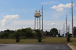
Hawkinsville is a city in and the county seat of Pulaski County, Georgia, United States. The population was 3,980 in 2020.

<span class="mw-page-title-main">Talbotton, Georgia</span> City in Georgia, United States

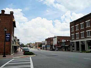
Talbotton is a city in Talbot County, Georgia, United States. The population was 970 at the 2010 census. The city is the county seat of Talbot County.

<span class="mw-page-title-main">Georgia State Route 247</span> State highway in Georgia, United States

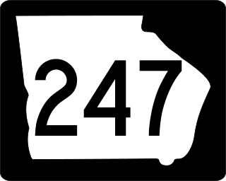
State Route 247 (SR 247) is a 43.2-mile-long (69.5 km) south–north state highway located in the central part of the U.S. state of Georgia. Its routing is within portions of Pulaski, Houston, and Bibb counties. It originates in the northwestern part of Hawkinsville, and it concludes in the northwestern section of Macon.

<span class="mw-page-title-main">Central Georgia</span> Area containing the metropolitan region surrounding the city of Macon

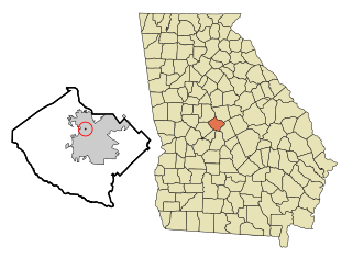
Central Georgia, or Middle Georgia and the Heart of Georgia, is an eleven-county region in the U.S. state of Georgia. It abuts the Atlanta metropolitan area, just to the north, and is anchored by both the Macon and Warner Robins metropolitan areas.

<span class="mw-page-title-main">Macon metropolitan area, Georgia</span> Metropolitan statistical area in Georgia, United States

The Macon metropolitan area is a metropolitan statistical area consisting of five counties in Central Georgia, anchored by the principal city of Macon. At the 2010 U.S. census, the five-county area had a population of 232,293. A July 2017 estimate placed the population at 228,914. In 2022, its estimated population was 235,805.

<span class="mw-page-title-main">U.S. Route 41 in Georgia</span> Segment of American highway

U.S. Route 41 (US 41) is a part of the United States Numbered Highway System that runs from Miami, Florida, to the Upper Peninsula of the US state of Michigan. In the U.S. state of Georgia it travels 387 miles (623 km) from the Florida state line southeast of Lake Park to the Tennessee state line south of East Ridge, Tennessee. Within the state, US 41 is paralleled by Interstate 75 (I-75) all the way from Florida to Tennessee, and I-75 has largely supplanted US 41 as a major highway. Due to this, the majority of the highway is not part of the National Highway System.

<span class="mw-page-title-main">Georgia State Route 127</span> State highway in Georgia, United States

State Route 127 (SR 127) is a 65.6-mile-long (105.6 km) state highway that runs west-to-east through portions of Marion, Taylor, Macon, and Houston counties in the west-central and central parts of the U.S. state of Georgia. It connects the north-central part of Marion County with the Perry–Warner Robins area.

The Warner Robins metropolitan area is a metropolitan statistical area located in Central Georgia. The Warner Robins MSA is a component of the larger Macon-Warner Robins-Fort Valley combined statistical area. As of 2020, its population was 191,614.

<span class="mw-page-title-main">Robins Air Force Base</span> US Air Force base at Warner Robins, Georgia, United States

Robins Air Force Base is a major United States Air Force installation located in Houston County, Georgia, United States. The base is located just east of the city of Warner Robins, 18 mi (29 km) south-southeast of Macon and approximately 100 mi (160 km) south-southeast of Atlanta, Georgia. The base is named in honor of Brig Gen Augustine Warner Robins, the Air Force's "father of logistics". The base is the single largest industrial complex in Georgia, employing a workforce of over 25,584 civilian, contractor, and military members.

References

  1. "2020 U.S. Gazetteer Files". United States Census Bureau. Retrieved December 18, 2021.
  2. "U.S. Census website". United States Census Bureau . Retrieved January 31, 2008.
  3. "US Board on Geographic Names". United States Geological Survey. October 25, 2007. Retrieved January 31, 2008.
  4. 1 2 "Geographic Identifiers: 2010 Demographic Profile Data (G001): Centerville city, Georgia". American Factfinder. U.S. Census Bureau. Retrieved May 19, 2017.[ dead link ]
  5. Krakow, Kenneth K. (1975). Georgia Place-Names: Their History and Origins (PDF). Macon, GA: Winship Press. p. 38. ISBN   0-915430-00-2.
  6. "US Gazetteer files: 2010, 2000, and 1990". United States Census Bureau. February 12, 2011. Retrieved April 23, 2011.
  7. "Census of Population and Housing". Census.gov. Retrieved June 4, 2015.
  8. "Explore Census Data". data.census.gov. Retrieved December 18, 2021.